world.wikisort.org - USA
The Northern United States, commonly referred to as the American North, the Northern States, or simply the North, is a geographical or historical region of the United States.
Northern United States | |
|---|---|
Region | |
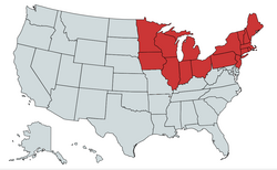 The states shown in red are included in the general term Northern United States. | |
| Country | |
| States | |
| Subregions | Northeastern United States Midwestern United States |
| Area | |
| • Total | 625,897.06 sq mi (1,621,065.9 km2) |
| • Land | 540,298.08 sq mi (1,399,365.6 km2) |
| Population | |
| • Total | 111,736,936 |
| • Density | 180/sq mi (69/km2) |
History
Early history
Before 19th century westward expansion, the "Northern United States" corresponded to the present day New England region. By the 1830s it corresponded to the present day Northeast and Great Lakes region.
Before 1865, the North was distinguished from the South on the issue of slavery. In Southern states, slavery was legal until the ratification of the 13th Amendment in 1865. Northern states had all passed some form of legislation to abolish slavery by 1804. However, abolition did not mean freedom for some existing slaves. Due to gradual abolition laws, slaves would still appear in some Northern states as far as the 1840 United States Census.[4] New Jersey was the last Northern state to end slavery. Due to their states gradual abolition laws, slavery came to an end in New Jersey when the 13th Amendment was ratified in 1865.[5]
American Civil War
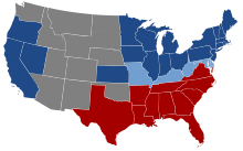
During the American Civil War (1861–1865), the Northern states comprised the U.S. states that supported the United States of America (the Union states). In this context, "The North" is synonymous with "the Union," while "The South" refers to the states that seceded from the U.S. in order to form the Confederate States of America.
There is, however, some historical disagreement as to exactly which states comprised "The North" in the context of the Civil War as five slave-holding states remained with the Union: the border states of Missouri, Kentucky, West Virginia, Maryland, and Delaware, alongside the disputed Indian Territory; depending on the source, these states and territories may be included in either region.[6]
Geography
Geographically, the term includes the U.S. states and regions of the United States of America that are located across the northernmost part of the country. It includes states along the Canada–United States border.
Census Bureau
The United States Census Bureau divides some of the northernmost United States into the Midwest Region and the Northeast Region.[7] The U.S. Census Bureau also includes the northernmost states of the Northwest, that are within the West Region.[7]
Urban centers
Among the larger cities by population in the Northern United States are: New York City, Chicago, Philadelphia, Boston, Pittsburgh, Columbus, Indianapolis, Cleveland, Cincinnati, Minneapolis, St. Paul, Buffalo, Milwaukee, Detroit, and Des Moines.
The Northern United States also comprises most of the Northeast megalopolis, which is the most populated and urbanized megalopolis in the United States. The Great Lakes megalopolis is also located in the Northern United States, largely in the Great Lakes region and Midwest.
Climate
The Northern United States has a humid continental climate. The Northern United states mostly gets large amounts of snow during the winter.
See also
- Northern Tier (United States)
- Flora of the Northern United States
- Southern United States
- Southeastern United States
- Southwestern United States
- Yankee
References
- "United States Summary: 2010, Population and Housing Unit Counts, 2010 Census of Population and Housing" (PDF). United States Census Bureau. September 2012. pp. V–2, 1 & 41 (Tables 1 & 18). Retrieved February 7, 2014.
- https://www2.census.gov/programs-surveys/popest/tables/2020-2021/state/totals/NST-EST2021-POP.xlsx [bare URL spreadsheet file]
- "Population, Population Change, and Estimated Components of Population Change: April 1, 2010 to July 1, 2019 (NST-EST2019-alldata)". Census.gov. United States Census Bureau. Archived from the original on January 26, 2020. Retrieved 8 February 2020.
- Klein, Christopher. (Feb 5, 2019). Deeper Roots of Northern Slavery Unearthed - HISTORY. Retrieved Jul 28, 2020.
- New Jersey, The Last Northern State to End Slavery - NJ.gov. nj.gov. Retrieved January 27, 2022.
- "the North (region, United States)". Encyclopædia Britannica Online. 2009. Retrieved 2009-10-27.
- "Census Regions and Divisions of the United States" (PDF). United States Census Bureau. Archived from the original (PDF) on 2013-01-07. Retrieved 2009-10-27.
Другой контент может иметь иную лицензию. Перед использованием материалов сайта WikiSort.org внимательно изучите правила лицензирования конкретных элементов наполнения сайта.
WikiSort.org - проект по пересортировке и дополнению контента Википедии