world.wikisort.org - USA
St. Landry Parish (French: Paroisse de Saint-Landry) is a parish located in the U.S. state of Louisiana. As of the 2010 Census, the population was 83,384.[1] The parish seat is Opelousas.[2] The parish was established in 1807.[3]
St. Landry Parish | |
|---|---|
Parish | |
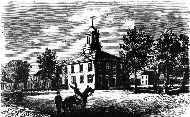 The St. Landry Parish Courthouse in Opelousas during the Civil War | |
 Location within the U.S. state of Louisiana | |
 Louisiana's location within the U.S. | |
| Coordinates: 30°36′N 92°00′W | |
| Country | |
| State | |
| Founded | 1807 |
| Named for | St. Landry Catholic Church |
| Seat | Opelousas |
| Largest city | Opelousas |
| Area | |
| • Total | 939 sq mi (2,430 km2) |
| • Land | 924 sq mi (2,390 km2) |
| • Water | 15 sq mi (40 km2) 1.6% |
| Population (2020) | |
| • Total | 82,540 |
| • Estimate (2022) | 82,786 |
| • Density | 88/sq mi (34/km2) |
| Time zone | UTC−6 (Central) |
| • Summer (DST) | UTC−5 (CDT) |
| Congressional districts | 3rd, 4th, 5th |
| Website | stlandrypg |
St. Landry Parish comprises the Opelousas, LA Micropolitan Statistical Area (μSA), which is also included in the Lafayette-Opelousas-Morgan City, LA Combined Statistical Area. It is at the heart of Creole and Cajun culture and heritage in Louisiana.
History
French and Spanish Territory
The land that became St. Landry Parish was inhabited since at least 10,500 B.C., as deduced from excavations of three prehistoric dwelling sites. By the 15th century, the Opelousa Indians settled in the area situated between Atchafalaya River and Sabine River (at the border of Texas-Louisiana). The Opelousa were war-like and preyed on neighbors to defend their own territory.
The first European recorded in the Opelousa territory was a French trader named Michel de Birotte. He came in 1690 and negotiated with the Opelousa nation.[citation needed] Nine years later, France named Louisiana as a colony and defined the land occupied by the Opelousa as the Opelousas Territory. The area south of the Opelousas Territory between the Atchafalaya River, the Gulf of Mexico and Bayou Nezpique, occupied by the Attakapas Indians (Eastern Atakapa), was named Attakapas Territory.
In 1764, France established the Opelousas Post slightly north of the contemporary city of Opelousas (near present-day Washington).[4] It was a major trading organization for the developing area. In addition, France established the Attakapas Post (near the present-day St. Martinville) in the Attakapas Territory, in 1765. France gave land grants to soldiers and settlers to encourage development. Most settlers were French immigrants. Tradition says that Jean Joseph LeKintrek and Joseph Blainpain, who had formed a partnership to trade with the Opelousa Indians, came in the early 1740s. They brought three enslaved Africans, the first to live in the area.
Some Indians sold land to the newcomers. When the Eastern Attakapas Chief Kinemo sold all the land between Vermilion River and Bayou Teche to Frenchman Gabriel Fuselier de la Claire in 1760, however, the angry Opelousa tribe exterminated the Attakapas (Eastern Atakapa).
France ceded Louisiana and its territories to Spain in 1762. Under Spanish rule, Opelousas Post became the center of government for Southwest Louisiana. By 1769 about 100 families were living in Opelousas Post. Between 1780 and 1820, the first settlers were joined by others coming from the Attakapas Territory, from the Pointe Coupée Territory, and east from the Atchafalaya River area. They were joined by immigrants from the French West Indies, who left after Haiti/St. Domingue became independent in a slave revolution. Most of the new settlers were French, Spaniards, French Creoles, Spanish Creoles, Africans and African-Americans.
The group from Attakapas Post included many Acadians. These were French who migrated from Nova Scotia in 1763, after their expulsion by the English in the aftermath of France's defeat in the Seven Years' War (known in North America as the French and Indian War). They were led by Jean-Jacques Blaise d'Abbadie. D'Abbadie was Governor of the territory from 1763 to 1765. The French community built St. Landry Catholic Church in 1765, dedicated to St. Landry (Landericus) of Paris, the Bishop of Paris in the 7th century.[5]
On April 10, 1805, after the United States had acquired the Louisiana Purchase, the post was named the town of Opelousas and became the seat of the County of Opelousas, part of the Territory of Orleans. In 1807, when the territory was reorganized into parishes, Opelousas was designated the seat of St. Landry Parish.[6]
Purchase by the United States

The United States gained control of the territory in 1803 through the Louisiana Purchase. Americans from the South and other parts of the United States began to migrate to the area, marking the arrival of the first large English-speaking population and the introduction of the need for more general use of English.[4]
St. Landry Parish was officially established on April 10, 1805 by a legislative act, becoming the largest parish in the Louisiana state. The new parish was named after the St. Landry Catholic Church located near the Opelousas Post.[4] The parish's boundaries encompassed about half the land of the Opelousas Territory, between the Atchafalaya River and Sabine River, between Rapides Parish and Vernon Parish, and Lafayette and St. Martin Parishes. Since then, the area of the parish has decreased, as six additional parishes have been created from its territory. These include Calcasieu, Acadia, Evangeline, Jeff Davis, Beauregard, and Allen.[4]
In 1821 the second educational institution west of the Mississippi was founded in Grand Coteau. In this community south of Opelousas is the Academy of the Sacred Heart, a private Catholic school founded by the French Creole community.[7]
The city of Opelousas has been the seat of government for the St. Landry Parish since its formation.[4] After Baton Rouge fell to the Union troops during the Civil War in 1862, Opelousas became the state capital for nine months. The capital was moved again in 1863, this time to Shreveport when Union troops occupied Opelousas.[8][9]
St. Landry Parish originally consisted of all the territory in the current parishes of Acadia, Evangeline, and St. Landry. Over time, it was separated into three different parishes. The southwestern portion of St. Landry was broken off to become Acadia Parish in 1886. A bill was introduced in the Louisiana House of Representatives entitled "An act to create the parish of Nicholls, and to provide for the organization thereof."[10] The title was later changed to read: "An act to create the parish of Acadia." Father Joseph Anthonioz, the first pastor of the Catholic Church at Rayne, is credited with having suggested the name, Acadia Parish. The bill passed the house on June 11, the senate on June 28, and was approved by Governor Samuel D. McEnery on June 30.[11] On October 6, an election was held to affirm the creation of the parish, with 2,516 votes for and 1,521 votes against the creation.
St. Landry was divided again when the northwestern portion was broken away. In June 1908, a bill was passed to create a new parish out of a portion of St. Landry Parish. This new parish became named Evangeline Parish in 1910. Prior to creation of the new parish, Eunice and Ville Platte were in competition for the new parish seat. Ville Platte was selected by voters on April 12, 1909. After the election, Eunice declared it would remain in St. Landry Parish.[12]
Opelousas massacre
In the aftermath of the ratification of Louisiana's Constitution of 1868 and the Fourteenth Amendment to the United States Constitution, tensions between white Democrats and Black Republicans in St. Landry Parish escalated throughout the summer of 1868. On September 28, white schoolteacher and Republican newspaper editor Emerson Bentley was attacked and beaten by three white supremacists while teaching a classroom of Black children in Opelousas, Louisiana. Rumors of Bentley's death, while unfounded, led both Black Republicans and white supremacist Democrats, including the St. Landry Parish chapter of the Knights of the White Camelia, to threaten violent retribution. In the days following Bentley's subsequent covert flight to New Orleans, the massacre began. Heavily outnumbered, Black citizens were chased, captured, shot, murdered, and lynched during the following weeks. While estimates of casualties vary widely, several sources number the deaths between 200 and 300 black people and several dozen whites, making it the bloodiest massacres of the Reconstruction Era and among the deadliest in American history. Following the massacre, the Republican Party in St. Landry Parish was eliminated for several years.[13]
2019 black church fires
During 10 days, three black churches, the St. Mary Baptist Church over 100 years old (26 March 2019), Greater Union Baptist Church (2 April 2019), and Mount Pleasant Baptist Church (4 April 2019) set on fire by a vandal and this incident raised officials concern that the fires started by racist and radical group or person. Finally, police arrested the vandal who was the son of a St. Landry Parish sheriff's deputy. Holden Matthews, 21, has been charged with the arson attack on black churches.[14][15][16]
Geography
According to the U.S. Census Bureau, the parish has a total area of 939 square miles (2,430 km2), of which 924 square miles (2,390 km2) is land and 15 square miles (39 km2) (0.6%) is water.[17]
Adjacent parishes
- Avoyelles Parish (north)
- Pointe Coupee Parish (east)
- St. Martin Parish (southeast)
- Lafayette Parish (south)
- Acadia Parish (southwest)
- Evangeline Parish (northwest)
National protected areas
- Atchafalaya National Wildlife Refuge (part)
- Jean Lafitte National Historical Park and Preserve (part, in Eunice)
Major highways
 Interstate 49
 U.S. Highway 71
 U.S. Highway 167
 U.S. Highway 190
 Louisiana Highway 10
 Louisiana Highway 29
 Louisiana Highway 31
 Louisiana Highway 35
 Louisiana Highway 93
 Louisiana Highway 103
 Louisiana Highway 182
Demographics
| Historical population | |||
|---|---|---|---|
| Census | Pop. | %± | |
| 1830 | 12,591 | — | |
| 1840 | 15,233 | 21.0% | |
| 1850 | 22,253 | 46.1% | |
| 1860 | 23,104 | 3.8% | |
| 1870 | 25,553 | 10.6% | |
| 1880 | 40,004 | 56.6% | |
| 1890 | 40,250 | 0.6% | |
| 1900 | 52,906 | 31.4% | |
| 1910 | 66,661 | 26.0% | |
| 1920 | 51,697 | −22.4% | |
| 1930 | 60,074 | 16.2% | |
| 1940 | 71,481 | 19.0% | |
| 1950 | 78,476 | 9.8% | |
| 1960 | 81,493 | 3.8% | |
| 1970 | 80,364 | −1.4% | |
| 1980 | 84,128 | 4.7% | |
| 1990 | 80,331 | −4.5% | |
| 2000 | 87,700 | 9.2% | |
| 2010 | 83,384 | −4.9% | |
| 2020 | 82,540 | −1.0% | |
| 2018 (est.) | 82,764 | [18] | −0.7% |
| U.S. Decennial Census[19] 1790-1960[20] 1900-1990[21] 1990-2000[22] 2010-2013[1] | |||
2020 census
| Race | Number | Percentage |
|---|---|---|
| White (non-Hispanic) | 43,225 | 52.37% |
| Black or African American (non-Hispanic) | 34,218 | 41.46% |
| Native American | 153 | 0.19% |
| Asian | 374 | 0.45% |
| Pacific Islander | 12 | 0.01% |
| Other/Mixed | 2,380 | 2.88% |
| Hispanic or Latino | 2,178 | 2.64% |
As of the 2020 United States census, there were 82,540 people, 30,441 households, and 20,790 families residing in the parish.
2010 census
As of the 2010 United States Census, there were 83,384 people living in the parish. 55.9% were White, 41.3% Black or African American, 0.4% Asian, 0.3% Native American, 0.8% of some other race and 1.3% of two or more races. 1.6% were Hispanic or Latino (of any race)
2000 census
As of the census[24] of 2000, there were 87,700 people, 32,328 households, and 23,211 families living in the parish. The population density was 94 people per square mile (36/km2). There were 36,216 housing units at an average density of 39 per square mile (15/km2). The racial makeup of the parish was 56.51% White, 42.13% Black or African American, 0.14% Native American, 0.20% Asian, 0.01% Pacific Islander, 0.31% from other races, and 0.70% from two or more races. 0.91% of the population were Hispanic or Latino of any race. 16.7% reported speaking French or Cajun French at home.[25]
There were 32,328 households, out of which 36.10% had children under the age of 18 living with them, 49.30% were married couples living together, 17.90% had a female householder with no husband present, and 28.20% were non-families. 25.40% of all households were made up of individuals, and 11.40% had someone living alone who was 65 years of age or older. The average household size was 2.67 and the average family size was 3.21.
In the parish the population was spread out, with 29.50% under the age of 18, 9.20% from 18 to 24, 26.50% from 25 to 44, 21.40% from 45 to 64, and 13.40% who were 65 years of age or older. The median age was 35 years. For every 100 females there were 91.60 males. For every 100 females age 18 and over, there were 86.80 males.
The median income for a household in the parish was $22,855, and the median income for a family was $28,908. Males had a median income of $29,458 versus $18,473 for females. The per capita income for the parish was $12,042. About 24.70% of families and 29.30% of the population were below the poverty line, including 37.70% of those under age 18 and 27.50% of those age 65 or over.
Law enforcement
| St. Landry Parish Sheriff's Office | |
|---|---|
| Abbreviation | SLPSO |
| Jurisdictional structure | |
| Operations jurisdiction | United States |
| General nature |
|
| Operational structure | |
| Headquarters | Opelousas, Louisiana |
| Agency executive |
|
| Facilities | |
| Substations | 5 |
| Website | |
| http://www.slpsheriff.com/ | |
The St. Landry Parish Sheriff's Office (SLPSO) is the primary law enforcement agency of St. Landry Parish. It falls under the authority of the Sheriff, who is the chief law enforcement officer of the parish. As of 2022[update] the sheriff of St. Landry Parish is Bobby J. Guidroz.[26]
The office briefly became the subject of national attention in 2015 when its eccentric Crime Stoppers videos, starring public relations officer (later U.S. Representative) Clay Higgins, went viral and were featured on The Tonight Show Starring Jimmy Fallon.[27] Higgins left the department after the videos attracted criticism from the ACLU and Sheriff Guidroz ordered that future videos be "toned down".[28][29]
Since the formation of the St. Landry Parish Sheriff's Office, one Sheriff has been killed in the line of duty.[30]
Politics
| Year | Republican | Democratic | Third parties |
|---|---|---|---|
| 2020 | 56.3% 23,171 | 42.2% 17,372 | 1.5% 611 |
| 2016 | 55.0% 21,971 | 43.1% 17,209 | 2.0% 797 |
| 2012 | 51.6% 21,475 | 47.2% 19,668 | 1.2% 504 |
| 2008 | 51.0% 21,650 | 47.7% 20,268 | 1.4% 575 |
| 2004 | 49.8% 18,315 | 49.4% 18,166 | 0.8% 279 |
| 2000 | 45.2% 15,449 | 52.9% 18,067 | 1.9% 635 |
| 1996 | 34.6% 12,273 | 58.2% 20,636 | 7.2% 2,544 |
| 1992 | 32.3% 11,882 | 55.4% 20,383 | 12.4% 4,550 |
| 1988 | 44.5% 15,790 | 53.8% 19,091 | 1.6% 576 |
| 1984 | 51.2% 19,055 | 48.2% 17,950 | 0.6% 218 |
| 1980 | 45.7% 14,940 | 52.4% 17,125 | 1.9% 613 |
| 1976 | 37.9% 9,956 | 59.5% 15,613 | 2.6% 674 |
| 1972 | 57.0% 12,510 | 33.8% 7,421 | 9.2% 2,014 |
| 1968 | 13.9% 3,508 | 36.0% 9,075 | 50.2% 12,659 |
| 1964 | 48.1% 10,920 | 52.0% 11,807 | |
| 1960 | 15.2% 3,083 | 72.2% 14,625 | 12.6% 2,554 |
| 1956 | 51.6% 5,141 | 44.5% 4,435 | 4.0% 394 |
| 1952 | 52.7% 5,303 | 47.3% 4,761 | |
| 1948 | 10.7% 829 | 15.2% 1,179 | 74.1% 5,739 |
| 1944 | 15.1% 784 | 84.9% 4,423 | |
| 1940 | 8.1% 561 | 91.9% 6,358 | |
| 1936 | 7.3% 441 | 92.8% 5,639 | |
| 1932 | 7.3% 297 | 92.7% 3,766 | |
| 1928 | 17.5% 718 | 82.5% 3,394 | |
| 1924 | 20.9% 357 | 79.1% 1,354 | |
| 1920 | 48.1% 942 | 51.9% 1,017 | |
| 1916 | 31.0% 117 | 36.9% 139 | 32.1% 121 |
| 1912 | 8.3% 101 | 77.2% 938 | 14.5% 176 |
Education
St. Landry Parish is served by the St. Landry Parish School Board
- Arnaudville Elementary (Grades 5-8)
- Beau Chene High School (Grades 9-12) (unincorporated Arnaudville)
- Cankton Elementary (Grades PK-4) (Cankton)
- Central Middle School (Grades 5-6)
- East Elementary (Grades PK-4)
- Eunice Elementary (Grades PK-4)
- Eunice High School (Grades 9-12)
- Eunice Jr. High School (Grades 7-8)
- Glendale Elementary (Grades PK-4)
- Grand Coteau Elementary (Grades PK-4) (Grand Coteau)
- Grand Prairie Elementary (Grades PK-4) (unincorporated Washington)
- Grolee Elementary (Grades PK-4)
- Highland Elementary (Grades PK-4)
- Krotz Springs Elementary (Grades PK-8)
- Lawtell Elementary (Grades PK-8) (Lawtell)
- Leonville Elementary (Grades PK-8)
- North Central High School (Grades 9-12) (unincorporated Washington)
- Northeast Elementary (Grades PK-6)
- Northwest High School (Grades 9-12) (unincorporated Opelousas)
- Opelousas Jr. High School (Grades 7-8)
- Opelousas Sr. High School (Grades 9-12)
- Palmetto Elementary (Grades PK-4) (Palmetto)
- Park Vista Elementary (Grades PK-6)
- Plaisance Elementary (Grades 5-8) (unincorporated Opelousas)
- Port Barre Elementary (Grades PK-4)
- Port Barre High School (Grades 5-12)
- South Street Elementary (Grades PK-6)
- Sunset Elementary (Grades 5-8)
- Washington Elementary (Grades PK-8)
St. Landry Parish is also served by the Diocese of Lafayette with five schools:
- Academy of the Sacred Heart (Grades PK-12) (Grand Coteau)
- Berchman's Academy of the Sacred Heart (Grades PK-12) (Grand Coteau)
- Opelousas Catholic School (Grades PK-12) (Opelousas)
- St. Edmunds Catholic School (Grades PK-12) (Eunice)
- St. Ignatius Catholic School (Grades PK-8) (Grand Coteau)
Additionally, St. Landry Parish is served by four unaffiliated private schools:
- Good Shephard Montessori School (Grades PK-8) (Port Barre)
- Melville Private School (Grades PK-7) (Melville)
- Opelousas Family Worship School (Grades PK-12) (Opelousas)
- Westminster Christian Academy (Grades PK-12)
St. Landry Parish is served by two institutions of higher education:
- Louisiana State University at Eunice
- South Louisiana Community College service area,[32] T. H. Harris Campus (Opelousas)
Communities

Cities
Towns
Villages
Unincorporated areas
Census-designated place
Other unincorporated communities
Notable people
- Lottie Beebe
- Rod Bernard
- Gerald Boudreaux
- Armand Brinkhaus
- Lonnie Brooks
- Tony Chachere
- Clifton Chenier
- Cat Doucet
- Gilbert L. Dupré
- E. D. Estilette
- Gregory L. Fruge
- Gordon (slave)
- Curtis J. Guillory
- Elbert Guillory
- Mickey Guillory
- T. H. Harris
- Clay Higgins
- Curtis Joubert
- Bernard LeBas
- Mildred Methvin
- Felix Octave Pavy
- Paul Prudhomme
- Dale Sittig
- Devery Henderson
- Herman Fuselier
See also
- National Register of Historic Places listings in St. Landry Parish, Louisiana
- Louisiana black church fires
References
- "State & County QuickFacts". United States Census Bureau. Retrieved August 18, 2013.
- "Find a County". National Association of Counties. Retrieved June 7, 2011.
- "St. Landry Parish". Center for Cultural and Eco-Tourism. Retrieved September 6, 2014.
- Hartley, Carola (2003). "Imperial St. Landry Parish". LAGenWeb. Archived from the original on September 21, 2007. Retrieved March 21, 2007.
- Central Acadiana Gateway: Opelousas and St. Landry Parish, Louisiana State University-Eunice Office of Public Relations Archived 2007-04-01 at the Wayback Machine, accessed 27 April 2008
- "History of Opelousas | City of Opelousas: Perfectly Seasoned". www.cityofopelousas.com. Retrieved March 9, 2018.
- Central Acadiana Gateway: Opelousas and St. Landry Parish, LSUE Office of Public Relations, 2000 Archived 2007-04-01 at the Wayback Machine, accessed 27 April 2008
- "Opelousas and St. Landry Parish". Louisiana State University - Eunice. Archived from the original on April 1, 2007. Retrieved March 19, 2007.
- "Opelousas Facts and History". City of Opelousas. Archived from the original on July 5, 2007. Retrieved March 19, 2007.
- "Official Journal of the Proceedings of the House of Representatives of the State of Louisiana". 1886.
- Fontenot, Mary.Acadia Parish, Louisiana. The Center for Louisiana Studies, 1976, p. 244.
- "Evangeline Parish History" (PDF). www.lacollege.edu.
- Boissoneault, Lorraine (September 28, 2018). "The Deadliest Massacre in Reconstruction-Era Louisiana Happened 150 Years Ago". Smithsonian Magazine. Archived from the original on September 30, 2021. Retrieved September 30, 2021.
- Ingber, Sasha (April 11, 2019). "'Evil Acts': Son Of Sheriff's Deputy Is Chief Suspect In Louisiana Church Arson Cases". National Public Radio. Retrieved April 11, 2019.
- Blinder, Alan; Fausset, Richard; Eligon, John (April 11, 2019). "A Charred Gas Can, a Receipt and an Arrest in Fires of 3 Black Churches". New York Times.
- McLaughlin, Eliott C. "Prosecutor adds hate crimes to charges against Louisiana church fire suspect". CNN. Retrieved April 17, 2019.
- "2010 Census Gazetteer Files". United States Census Bureau. August 22, 2012. Archived from the original on September 28, 2013. Retrieved September 1, 2014.
- "Population and Housing Unit Estimates". Retrieved October 27, 2019.
- "U.S. Decennial Census". United States Census Bureau. Retrieved September 1, 2014.
- "Historical Census Browser". University of Virginia Library. Retrieved September 1, 2014.
- "Population of Counties by Decennial Census: 1900 to 1990". United States Census Bureau. Retrieved September 1, 2014.
- "Census 2000 PHC-T-4. Ranking Tables for Counties: 1990 and 2000" (PDF). United States Census Bureau. Retrieved September 1, 2014.
- "Explore Census Data". data.census.gov. Retrieved December 29, 2021.
- "U.S. Census website". United States Census Bureau. Retrieved January 31, 2008.
- "Language Map Data Center". www.mla.org. Retrieved March 9, 2018.
- "Information about Sheriff Bobby J. Guidroz, St. Landry Parish". St. Landry Parish Sheriff's Office. Sheriff Guidroz is a 1994 graduate of the F.B. I. National Academy. Retrieved September 29, 2012.
- Stickney, Ken (December 16, 2016). "Higgins carves unlikely path to Capitol". The Daily Advertiser.
- bgunn@theadvocate.com, billy gunn. "ACLU blasts St. Landry's law and order sheriff's captain over comments on latest viral video". The Advocate. Retrieved October 19, 2022.
- "Higgins Leaves St. Landry Parish Sheriff's Office". acadiaparishtoday.com. February 29, 2016. Retrieved October 18, 2022.
- "St. Landry Parish Sheriff's Office, LA". The Officer Down Memorial Page (ODMP). Retrieved October 19, 2022.
- Leip, David. "Dave Leip's Atlas of U.S. Presidential Elections". uselectionatlas.org. Retrieved March 9, 2018.
- "Our Colleges". Louisiana's Technical and Community Colleges. Retrieved June 3, 2021.
Resources
- Nezat, Jack Claude (2007). The Nezat and Allied Families 1630-2007 (Paperback ed.). Lulu. ISBN 978-2-9528339-2-9., ISBN 978-0-615-15001-7.[self-published source?]
- Nezat, Jack Claude (March 24, 2021). The Nezat and Allied Families 1630-2020 (Kindle ed.). Lulu. ISBN 9798727857359.[self-published source?]
- The author is one of the descendants of "Alexandre of Attakapas", Nezat Alexandre, born 1781 in Attakapas Post and died 1824 (Source Hebert).
External links
- Official Web Site of St. Landry Parish Government
- Website for St. Landry Catholic Church Parish
- St. Landry Parish Sheriff's Office
- St. Landry Parish Tourist Commission
Geology
- Heinrich, P. V., and W. J. Autin, 2000, Baton Rouge 30 x 60 minute geologic quadrangle. Louisiana Geological Survey, Baton Rouge, Louisiana.
- Heinrich, P. V., J. Snead, and R. P. McCulloh, 2003, Crowley 30 x 60 minute geologic quadrangle. Louisiana Geological Survey, Baton Rouge, Louisiana.
- Snead, J., P. V. Heinrich, and R. P. McCulloh, 2002, Ville Platte 30 x 60 minute geologic quadrangle. Louisiana Geological Survey, Baton Rouge, Louisiana.
Places adjacent to St. Landry Parish, Louisiana | ||||||||||||||||
|---|---|---|---|---|---|---|---|---|---|---|---|---|---|---|---|---|
| ||||||||||||||||
Municipalities and communities of St. Landry Parish, Louisiana, United States | ||
|---|---|---|
Parish seat: Opelousas | ||
| Cities | 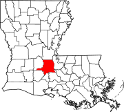 | |
| Towns | ||
| Villages | ||
| CDPs | ||
| Other communities |
| |
| Footnotes | ‡This populated place also has portions in an adjacent parish or parishes | |
| ||
Authority control | |
|---|---|
| General | |
| National libraries | |
| Other |
|
На других языках
[de] St. Landry Parish
Das St. Landry Parish[1] (französisch Paroisse de Saint-Landry) ist ein Parish im Bundesstaat Louisiana der Vereinigten Staaten. Bei der Volkszählung im Jahr 2010 hatte das Parish 83.384 Einwohner und eine Bevölkerungsdichte von 34,7 Einwohnern je Quadratkilometer. Der Verwaltungssitz (Parish Seat) ist Opelousas.- [en] St. Landry Parish, Louisiana
[ru] Сент-Лэндри
Прихо́д Сент-Лэ́ндри (англ. Saint Landry Parish) или Сен-Ландри́ (фр. Paroisse de Saint-Landry) — один из приходов штата Луизиана, США. Официально образован в 1807 году. По состоянию на 2010 год, численность населения составляла 83 384 человека.Другой контент может иметь иную лицензию. Перед использованием материалов сайта WikiSort.org внимательно изучите правила лицензирования конкретных элементов наполнения сайта.
WikiSort.org - проект по пересортировке и дополнению контента Википедии