world.wikisort.org - USA
Lincoln Parish (French: Paroisse de Lincoln) is a parish located in the U.S. state of Louisiana. As of the 2010 census, the population was 46,735.[1] The parish seat is Ruston.[2] The parish was created on February 24, 1873, from parts of Bienville, Claiborne, Union, and Jackson parishes, and its boundaries have changed only once (in 1877). This makes Lincoln Parish one of the Reconstruction parishes.[3]
Lincoln Parish, Louisiana | |
|---|---|
Parish | |
| Parish of Lincoln | |
 Lincoln Parish Courthouse in Ruston | |
 Flag | |
 Location within the U.S. state of Louisiana | |
 Louisiana's location within the U.S. | |
| Country | |
| State | |
| Region | North Louisiana |
| Founded | 1873 |
| Named for | Abraham Lincoln |
| Parish seat (and largest city) | Ruston |
| Area | |
| • Total | 1,220 km2 (472 sq mi) |
| • Land | 1,220 km2 (472 sq mi) |
| • Water | 2 km2 (0.7 sq mi) |
| • percentage | 0.5 km2 (0.2 sq mi) |
| Population (2010) | |
| • Total | 46,735 |
| • Estimate (2018) | 47,196 |
| • Rank | LA: 25th |
| • Density | 38/km2 (99/sq mi) |
| Time zone | UTC-6 (CST) |
| • Summer (DST) | UTC-5 (CDT) |
| Area code | 318 |
| Congressional district | 5th |
| Website | Parish of Lincoln |


Lincoln Parish comprises the Ruston, LA Micropolitan Statistical Area.
History
Since the late 20th century, archeologists have dated eleven sites in northern Louisiana where thousands of years ago, indigenous cultures built complexes with multiple, monumental earthwork mounds during the Middle Archaic period, long before the development of sedentary, agricultural societies. At sites such as Watson Brake, Frenchman's Bend, and Caney, generations of hunter-gatherers worked for hundreds of years to build and add to mound complexes. Hedgepeth Site, located in Lincoln Parish, is dated about 5200–4500 BP (about 3300–2600 BCE), from the latter part of this period. Such finds are changing the understanding of early human cultures.[4]
The parish was one of several new ones established by the state legislature during Reconstruction; in 1873 it was formed from land that had belonged to Bienville, Claiborne, Jackson and Union parishes to create one in which newly elected representatives might have more ties to the Republican Party. It was an attempt to break up the old order of political power, and to capitalize on the arrival of the railroad line. The parish is named for the late U.S. president Abraham Lincoln.[5]
In 1934, the historian Robert W. Mondy of Louisiana Tech University in Ruston completed a thesis entitled "A History of Lincoln Parish, Louisiana" as part of the requirements for his Master of Arts degree from the University of Texas at Austin.[6] Another Louisiana Tech faculty member, Robert C. Snyder, was instrumental in the establishment in 1962 of the Lincoln Parish Library. He served as the library board president for many years.[7]
Lincoln Parish is usually Republican in contested elections. In 2012, Republican presidential nominee Mitt Romney won the parish with 10,739 votes (56.5 percent) to U.S. President Barack H. Obama, the Democrat who polled 7,956 ballots (41.9 percent).[8]
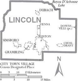
Geography
According to the U.S. Census Bureau, the parish has a total area of 472 square miles (1,220 km2), of which 472 square miles (1,220 km2) is land and 0.7 square miles (1.8 km2) (0.2%) is water.[9]
Major highways
 Interstate 20
 U.S. Highway 80
 U.S. Highway 167
 Louisiana Highway 33
Adjacent parishes
- Union Parish (north)
- Ouachita Parish (east)
- Jackson Parish (south)
- Bienville Parish (southwest)
- Claiborne Parish (northwest)
Demographics
| Historical population | |||
|---|---|---|---|
| Census | Pop. | %± | |
| 1880 | 11,075 | — | |
| 1890 | 14,753 | 33.2% | |
| 1900 | 15,898 | 7.8% | |
| 1910 | 18,485 | 16.3% | |
| 1920 | 16,962 | −8.2% | |
| 1930 | 22,822 | 34.5% | |
| 1940 | 24,790 | 8.6% | |
| 1950 | 25,782 | 4.0% | |
| 1960 | 28,535 | 10.7% | |
| 1970 | 33,800 | 18.5% | |
| 1980 | 39,763 | 17.6% | |
| 1990 | 41,745 | 5.0% | |
| 2000 | 42,509 | 1.8% | |
| 2010 | 46,735 | 9.9% | |
| 2018 (est.) | 47,196 | [10] | 1.0% |
| U.S. Decennial Census[11] 1790-1960[12] 1900-1990[13] 1990-2000[14] 2010-2013[1] | |||
2020 census
| Race | Number | Percentage |
|---|---|---|
| White (non-Hispanic) | 25,672 | 53.05% |
| Black or African American (non-Hispanic) | 18,626 | 38.49% |
| Native American | 145 | 0.3% |
| Asian | 682 | 1.41% |
| Pacific Islander | 5 | 0.01% |
| Other/Mixed | 1,512 | 3.12% |
| Hispanic or Latino | 1,754 | 3.62% |
As of the 2020 United States census, there were 48,396 people, 17,712 households, and 10,407 families residing in the parish.
2010 census
As of the 2010 United States Census, there were 46,735 people living in the parish. 55.2% were White, 40.5% Black or African American, 1.7% Asian, 0.3% Native American, 0.1% Pacific Islander, 1.3% of some other race and 1.1% of two or more races. 2.5% were Hispanic or Latino (of any race).
2000 census
As of the census[16] of 2000, there were 42,509 people, 15,235 households, and 9,689 families living in the parish. The population density was 90 people per square mile (35/km2). There were 17,000 housing units at an average density of 36 per square mile (14/km2). The racial makeup of the parish was 57.42% White, 39.84% Black or African American, 0.18% Native American, 1.28% Asian, 0.01% Pacific Islander, 0.52% from other races, and 0.75% from two or more races. 1.16% of the population were Hispanic or Latino of any race.
There were 15,235 households, out of which 30.00% had children under the age of 18 living with them, 44.50% were married couples living together, 15.30% had a female householder with no husband present, and 36.40% were non-families. 27.00% of all households were made up of individuals, and 9.40% had someone living alone who was 65 years of age or older. The average household size was 2.44 and the average family size was 3.01.
In the parish the population was spread out, with 22.10% under the age of 18, 25.70% from 18 to 24, 23.20% from 25 to 44, 17.60% from 45 to 64, and 11.30% who were 65 years of age or older. The median age was 26 years. For every 100 females, there were 94.20 males. For every 100 females age 18 and over, there were 90.90 males.
The median income for a household in the parish was $26,977, and the median income for a family was $38,972. Males had a median income of $32,376 versus $20,877 for females. The per capita income for the parish was $14,313. About 18.20% of families and 26.50% of the population were below the poverty line, including 30.10% of those under age 18 and 18.10% of those age 65 or over.
Education
Lincoln Parish residents are zoned to Lincoln Parish School Board schools.
The parish is home to Louisiana Tech University in Ruston, and Grambling State University in Grambling.
Bethel Christian School is located in Ruston.
Ruston High School is located in Ruston.
Lincoln Preparatory School is located in Grambling.
Choudrant Elementary School and Choudrant High School are located in Choudrant.
National Guard
527th Engineer Battalion (Triple Alpha) ("Anything, Anytime, Anywhere") is headquartered in Ruston, Louisiana, the parish seat. This battalion is part of the 225th Engineer Brigade of the Louisiana National Guard.
Attractions
- Eddie G. Robinson Museum
- Lincoln Parish Park
- Louisiana Military Museum
- Lincoln Parish Museum
- Dixie Center for the Arts
- North Central Louisiana Arts Council
- Ruston Community Theatre
- Celebrity Theatre (movie theater)
- Annual Peach Festival held in Ruston
- Annual Chicken Festival held in Dubach
- Kingdom Collectives Film Festival held in Ruston
Communities
Cities
Towns
Villages
Unincorporated communities
- Corinth
- Mount Zion
- Pleasant Hill
- Hico
- Hilly
- Unionville
Politics
| Year | Republican | Democratic | Third parties |
|---|---|---|---|
| 2020 | 58.7% 11,311 | 39.2% 7,559 | 2.1% 405 |
| 2016 | 57.6% 10,761 | 38.1% 7,107 | 4.3% 801 |
| 2012 | 56.5% 10,739 | 41.9% 7,956 | 1.6% 298 |
| 2008 | 55.7% 10,680 | 43.2% 8,292 | 1.1% 207 |
| 2004 | 59.2% 10,791 | 39.8% 7,242 | 1.0% 185 |
| 2000 | 55.9% 9,246 | 41.4% 6,851 | 2.7% 454 |
| 1996 | 44.0% 6,973 | 49.9% 7,903 | 6.2% 979 |
| 1992 | 43.6% 7,220 | 43.5% 7,205 | 12.9% 2,136 |
| 1988 | 60.4% 8,853 | 37.0% 5,427 | 2.6% 377 |
| 1984 | 61.8% 9,087 | 37.0% 5,432 | 1.2% 182 |
| 1980 | 55.8% 7,515 | 41.6% 5,598 | 2.7% 357 |
| 1976 | 57.1% 6,828 | 41.5% 4,971 | 1.4% 170 |
| 1972 | 69.2% 6,736 | 26.6% 2,589 | 4.3% 416 |
| 1968 | 29.8% 2,643 | 22.6% 2,009 | 47.6% 4,225 |
| 1964 | 77.1% 5,766 | 22.9% 1,714 | |
| 1960 | 54.1% 2,766 | 20.6% 1,051 | 25.3% 1,292 |
| 1956 | 59.2% 2,676 | 22.4% 1,014 | 18.4% 830 |
| 1952 | 60.5% 3,074 | 39.5% 2,009 | |
| 1948 | 11.0% 353 | 19.5% 625 | 69.4% 2,223 |
| 1944 | 37.7% 1,032 | 62.3% 1,705 | |
| 1940 | 13.1% 449 | 86.9% 2,969 | |
| 1936 | 8.5% 201 | 91.4% 2,154 | 0.0% 1 |
| 1932 | 7.9% 163 | 92.1% 1,908 | |
| 1928 | 39.2% 670 | 60.8% 1,041 | |
| 1924 | 13.5% 157 | 86.2% 1,005 | 0.3% 4 |
| 1920 | 15.6% 183 | 84.4% 989 | |
| 1916 | 4.3% 42 | 95.3% 932 | 0.4% 4 |
| 1912 | 0.4% 3 | 84.5% 644 | 15.1% 115 |
See also
- National Register of Historic Places listings in Lincoln Parish, Louisiana
- George M. Lomax
- Ragan Madden
- L.D. "Buddy" Napper
References
- "State & County QuickFacts". United States Census Bureau. Archived from the original on June 6, 2011. Retrieved August 10, 2013.
- "Find a County". National Association of Counties. Retrieved June 7, 2011.
- "" + theTitle + "". Archived from the original on March 29, 2015. Retrieved January 22, 2015.
- Robert W. Preucel, Stephen A. Mrozowski, Contemporary Archaeology in Theory: The New Pragmatism, John Wiley and Sons, 2010, p. 177
- Gannett, Henry (1905). The Origin of Certain Place Names in the United States. U.S. Government Printing Office. p. 187.
- "Louisiana parish books". Archived from the original on October 25, 2009. Retrieved June 19, 2010.
- "Robert C. Snyder Obituary". Shreveport Times. June 12, 2011. Retrieved June 21, 2011.
- "Lincoln Parish election returns, November 6, 2012". staticresults.sos.la.gov. Retrieved November 17, 2012.
- "2010 Census Gazetteer Files". United States Census Bureau. August 22, 2012. Archived from the original on September 28, 2013. Retrieved September 1, 2014.
- "Population and Housing Unit Estimates". Retrieved October 28, 2019.
- "U.S. Decennial Census". United States Census Bureau. Retrieved September 1, 2014.
- "Historical Census Browser". University of Virginia Library. Retrieved September 1, 2014.
- "Population of Counties by Decennial Census: 1900 to 1990". United States Census Bureau. Retrieved September 1, 2014.
- "Census 2000 PHC-T-4. Ranking Tables for Counties: 1990 and 2000" (PDF). United States Census Bureau. Retrieved September 1, 2014.
- "Explore Census Data". data.census.gov. Retrieved December 29, 2021.
- "U.S. Census website". United States Census Bureau. Retrieved January 31, 2008.
- Leip, David. "Dave Leip's Atlas of U.S. Presidential Elections". uselectionatlas.org. Retrieved March 7, 2018.
External links
Places adjacent to Lincoln Parish, Louisiana | ||||||||||||||||
|---|---|---|---|---|---|---|---|---|---|---|---|---|---|---|---|---|
| ||||||||||||||||
Municipalities and communities of Lincoln Parish, Louisiana, United States | ||
|---|---|---|
Parish seat: Ruston | ||
| Cities |  | |
| Towns | ||
| Villages | ||
| Unincorporated communities |
| |
| Footnotes | ‡This populated place also has portions in an adjacent parish or parishes | |
| ||
Authority control | |
|---|---|
| General | |
| National libraries | |
На других языках
[de] Lincoln Parish
Das Lincoln Parish[1] (frz.: Paroisse de Lincoln) ist ein Parish im Bundesstaat Louisiana der Vereinigten Staaten. Im Jahr 2010 hatte das Parish 46.735 Einwohner und eine Bevölkerungsdichte von 38,3 Einwohner pro Quadratkilometer. Der Verwaltungssitz (Parish Seat) ist Ruston.- [en] Lincoln Parish, Louisiana
[ru] Линкольн (приход)
Прихо́д Ли́нкольн (англ. Lincoln Parish, фр. Paroisse de Lincoln) — один из приходов штата Луизиана, США. Официально образован в 1873 году. По состоянию на 2010 год, численность населения составляла 46 735 человек. Назван в честь президента США Авраама Линкольна.Другой контент может иметь иную лицензию. Перед использованием материалов сайта WikiSort.org внимательно изучите правила лицензирования конкретных элементов наполнения сайта.
WikiSort.org - проект по пересортировке и дополнению контента Википедии