world.wikisort.org - USA
Madison County is a county located in the U.S. state of Mississippi. As of the 2010 census, the population was 95,203.[1] The county seat is Canton.[2] The county is named for U.S. President James Madison.[3]
Madison County | |
|---|---|
U.S. county | |
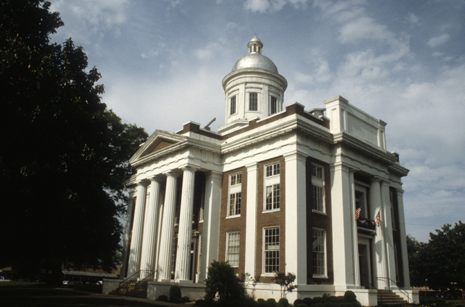 Madison County Courthouse in Canton | |
 Location within the U.S. state of Mississippi | |
 Mississippi's location within the U.S. | |
| Coordinates: 32°38′N 90°02′W | |
| Country | |
| State | |
| Founded | January 29, 1828 |
| Named for | James Madison |
| Seat | Canton |
| Largest city | Madison |
| Area | |
| • Total | 742 sq mi (1,920 km2) |
| • Land | 715 sq mi (1,850 km2) |
| • Water | 27 sq mi (70 km2) 3.7% |
| Population (2010) | |
| • Total | 95,203 |
| • Estimate (2020) | 109,145 |
| • Density | 130/sq mi (50/km2) |
| Time zone | UTC−6 (Central) |
| • Summer (DST) | UTC−5 (CDT) |
| Congressional districts | 2nd, 3rd |
| Website | www |
Madison County is part of the Jackson, MS Metropolitan Statistical Area.
Geography
According to the U.S. Census Bureau, the county has a total area of 742 square miles (1,920 km2), of which 715 square miles (1,850 km2) is land and 27 square miles (70 km2) (3.7%) is water.[4] The southeastern border of the county is defined by the old course of the Pearl River before it was dammed to create the 33,000 acres (130 km2) Ross Barnett Reservoir.
The boundaries of the county are set in Mississippi Code section 19-1-89 as: Madison County is bounded by beginning at a point on Big Black River, where the same crosses the center line in township twelve, range three, east; thence east to the old Choctaw boundary line; thence north on said boundary line to the center line of township twelve, range five, east; thence through the center of said township twelve, range five, east, to the range line between townships five and six, east; thence south on said range line to Pearl River; thence down said river, with its meanderings, to the line between townships six and seven, north; thence west on said township line to the basis meridian of the Choctaw survey; thence north on said meridian line to the line between townships seven and eight, north; thence west on said township line to the line between ranges two and three, west; thence north on said range line to Big Black River; thence up said river, with its meanderings, to the beginning.[5]
Major highways
 Interstate 55
 U.S. Highway 49
 U.S. Highway 51
 Mississippi Highway 16
 Mississippi Highway 17
 Mississippi Highway 22
 Mississippi Highway 43
- Natchez Trace Parkway
Adjacent counties
- Attala County (north)
- Leake County (east)
- Scott County (southeast)
- Rankin County (south)
- Hinds County (southwest)
- Yazoo County (west)
National protected area
- Natchez Trace Parkway (part)
Demographics
| Historical population | |||
|---|---|---|---|
| Census | Pop. | %± | |
| 1830 | 4,973 | — | |
| 1840 | 15,530 | 212.3% | |
| 1850 | 18,173 | 17.0% | |
| 1860 | 23,382 | 28.7% | |
| 1870 | 20,948 | −10.4% | |
| 1880 | 25,866 | 23.5% | |
| 1890 | 27,321 | 5.6% | |
| 1900 | 32,493 | 18.9% | |
| 1910 | 33,505 | 3.1% | |
| 1920 | 29,292 | −12.6% | |
| 1930 | 35,796 | 22.2% | |
| 1940 | 37,504 | 4.8% | |
| 1950 | 33,860 | −9.7% | |
| 1960 | 32,904 | −2.8% | |
| 1970 | 29,737 | −9.6% | |
| 1980 | 41,613 | 39.9% | |
| 1990 | 53,794 | 29.3% | |
| 2000 | 74,674 | 38.8% | |
| 2010 | 95,203 | 27.5% | |
| 2020 | 109,145 | 14.6% | |
| U.S. Decennial Census[6] 1790-1960[7] 1900-1990[8] 1990-2000[9] 2010-2014[1] | |||
2020 census
| Race | Num. | Perc. |
|---|---|---|
| White | 60,273 | 55.22% |
| Black or African American | 38,526 | 35.3% |
| Native American | 160 | 0.15% |
| Asian | 3,167 | 2.9% |
| Pacific Islander | 13 | 0.01% |
| Other/Mixed | 2,889 | 2.65% |
| Hispanic or Latino | 4,117 | 3.77% |
As of the 2020 United States Census, there were 109,145 people, 40,046 households, and 28,374 families residing in the county.
2000 census
As of the census[11] of 2000, there were 74,674 people, 27,219 households, and 19,325 families residing in the county. The population density was 104 people per square mile (40/km2). There were 28,781 housing units at an average density of 40 per square mile (16/km2). The racial makeup of the county was 60.29% White, 37.48% Black or African American, 0.11% Native American, 1.30% Asian, 0.02% Pacific Islander, 0.27% from other races, and 0.53% from two or more races. 0.99% of the population were Hispanic or Latino of any race.
There were 27,219 households, out of which 37.40% had children under the age of 18 living with them, 51.90% were married couples living together, 15.60% had a female householder with no husband present, and 29.00% were non-families. 25.00% of all households were made up of individuals, and 6.70% had someone living alone who was 65 years of age or older. The average household size was 2.67 and the average family size was 3.23.
In the county, the population was spread out, with 28.60% under the age of 18, 8.90% from 18 to 24, 32.40% from 25 to 44, 20.30% from 45 to 64, and 9.70% who were 65 years of age or older. The median age was 33 years. For every 100 females, there were 90.20 males. For every 100 females age 18 and over, there were 86.20 males.
The median income for a household in the county was $46,970, and the median income for a family was $58,172. Males had a median income of $41,460 versus $29,170 for females. The per capita income for the county was $23,469. About 10.60% of families and 14.00% of the population were below the poverty line, including 21.30% of those under age 18 and 13.20% of those age 65 or over.
Madison County has the highest per capita income in the State of Mississippi. It is the only county in Mississippi with a per capita income higher than the national average.
Communities
Cities
- Canton (county seat)
- Gluckstadt
- Madison
- Ridgeland
Town
Census-designated place
Other unincorporated communities
Ghost town
- Beatties Bluff
- Stokes
Government and infrastructure
The county operates the Madison County Jail. Normally pre-trial federal inmates from central Mississippi are held at this jail.[12]
| Year | Republican | Democratic | Third party | |||
|---|---|---|---|---|---|---|
| No. | % | No. | % | No. | % | |
| 2020 | 31,091 | 55.16% | 24,440 | 43.36% | 830 | 1.47% |
| 2016 | 28,265 | 56.38% | 20,343 | 40.58% | 1,523 | 3.04% |
| 2012 | 28,507 | 57.51% | 20,722 | 41.80% | 342 | 0.69% |
| 2008 | 27,203 | 57.55% | 19,831 | 41.95% | 235 | 0.50% |
| 2004 | 24,257 | 64.29% | 13,268 | 35.17% | 203 | 0.54% |
| 2000 | 19,109 | 64.00% | 10,416 | 34.88% | 334 | 1.12% |
| 1996 | 14,467 | 58.60% | 9,354 | 37.89% | 867 | 3.51% |
| 1992 | 12,810 | 54.00% | 9,386 | 39.57% | 1,525 | 6.43% |
| 1988 | 11,399 | 57.50% | 8,242 | 41.57% | 184 | 0.93% |
| 1984 | 9,298 | 53.24% | 8,002 | 45.82% | 163 | 0.93% |
| 1980 | 6,024 | 42.91% | 7,621 | 54.28% | 394 | 2.81% |
| 1976 | 4,838 | 42.75% | 6,240 | 55.14% | 238 | 2.10% |
| 1972 | 5,047 | 57.20% | 3,464 | 39.26% | 313 | 3.55% |
| 1968 | 876 | 9.26% | 4,515 | 47.72% | 4,071 | 43.02% |
| 1964 | 3,283 | 92.90% | 251 | 7.10% | 0 | 0.00% |
| 1960 | 525 | 18.35% | 753 | 26.32% | 1,583 | 55.33% |
| 1956 | 377 | 15.74% | 996 | 41.59% | 1,022 | 42.67% |
| 1952 | 1,496 | 51.22% | 1,425 | 48.78% | 0 | 0.00% |
| 1948 | 51 | 2.60% | 81 | 4.12% | 1,833 | 93.28% |
| 1944 | 104 | 5.14% | 1,921 | 94.86% | 0 | 0.00% |
| 1940 | 66 | 3.14% | 2,038 | 96.86% | 0 | 0.00% |
| 1936 | 32 | 1.71% | 1,838 | 98.24% | 1 | 0.05% |
| 1932 | 51 | 3.33% | 1,474 | 96.15% | 8 | 0.52% |
| 1928 | 124 | 7.55% | 1,519 | 92.45% | 0 | 0.00% |
| 1924 | 109 | 6.39% | 1,598 | 93.61% | 0 | 0.00% |
| 1920 | 57 | 6.36% | 831 | 92.75% | 8 | 0.89% |
| 1916 | 36 | 4.29% | 782 | 93.10% | 22 | 2.62% |
| 1912 | 11 | 1.50% | 663 | 90.45% | 59 | 8.05% |
Education
There are two school districts: Madison County School District and Canton Public School District.[14]
Private schools:
- Canton Academy
- Madison-Ridgeland Academy
- St. Andrew's Episcopal School (Secondary school campus)
- St. Joseph Catholic School (of the Roman Catholic Diocese of Jackson)
- Veritas School (CLOSED)
The local community college is Holmes Community College.[15]
Tougaloo College is in Madison County.[16]
See also
- National Register of Historic Places listings in Madison County, Mississippi
References
- "State & County QuickFacts". United States Census Bureau. Archived from the original on June 7, 2011. Retrieved September 4, 2013.
- "Find a County". National Association of Counties. Retrieved June 7, 2011.
- Gannett, Henry (1905). The Origin of Certain Place Names in the United States. U.S. Government Printing Office. p. 196.
- "2010 Census Gazetteer Files". United States Census Bureau. August 22, 2012. Archived from the original on September 28, 2013. Retrieved November 6, 2014.
- Mississippi Codes SEC. 19-1-89. Madison County. Archived 2011-06-10 at the Wayback Machine
- "U.S. Decennial Census". United States Census Bureau. Retrieved November 6, 2014.
- "Historical Census Browser". University of Virginia Library. Retrieved November 6, 2014.
- "Population of Counties by Decennial Census: 1900 to 1990". United States Census Bureau. Retrieved November 6, 2014.
- "Census 2000 PHC-T-4. Ranking Tables for Counties: 1990 and 2000" (PDF). United States Census Bureau. Retrieved November 6, 2014.
- "Explore Census Data". data.census.gov. Retrieved December 8, 2021.
- "U.S. Census website". United States Census Bureau. Retrieved January 31, 2008.
- Amy, Jeff (December 27, 2016). "Judge rejects Chris Epps' request to leave jail". Associated Press at the Hattiesburg American. Retrieved May 26, 2017. "He’s not listed in records at the Madison County jail, where federal prisoners in central Mississippi are usually confined."
- Leip, David. "Dave Leip's Atlas of U.S. Presidential Elections". uselectionatlas.org. Retrieved March 4, 2018.
- "2020 CENSUS - SCHOOL DISTRICT REFERENCE MAP: Madison County, MS" (PDF). U.S. Census Bureau. Retrieved June 30, 2021. - Text list
- "About Us". Holmes Community College. Retrieved June 30, 2021.
- "Home". Tougaloo College. Retrieved June 30, 2021.
500 West County Line Road • Tougaloo, MS 39174
- Compare with the county map.
Campus map: "Proposed Parking Plan" (PDF). Tougaloo College. Retrieved June 30, 2021.
Compare with a map of Madison County: "General Highway Map of Madison County, Mississippi" (PDF). Mississippi State Highway Department. 1987. Retrieved June 30, 2021.
Places adjacent to Madison County, Mississippi | ||||||||||||||||
|---|---|---|---|---|---|---|---|---|---|---|---|---|---|---|---|---|
| ||||||||||||||||
Municipalities and communities of Madison County, Mississippi, United States | ||
|---|---|---|
County seat: Canton | ||
| Cities | 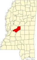 | |
| Towns | ||
| CDPs | ||
| Other communities | ||
| Ghost town | ||
| Footnotes | ‡This populated place also has portions in an adjacent county or counties | |
| ||
Authority control | |
|---|---|
| General | |
| National libraries | |
| Other |
|
На других языках
[de] Madison County (Mississippi)
Das Madison County[1] ist ein County im US-Bundesstaat Mississippi. Der Verwaltungssitz (County Seat) ist Canton.- [en] Madison County, Mississippi
[ru] Мадисон (округ, Миссисипи)
Округ Мадисон (англ. Madison County) — округ штата Миссисипи, США. Население округа на 2000 год составляло 74674 человек. Административный центр округа — город Кантон.Другой контент может иметь иную лицензию. Перед использованием материалов сайта WikiSort.org внимательно изучите правила лицензирования конкретных элементов наполнения сайта.
WikiSort.org - проект по пересортировке и дополнению контента Википедии