world.wikisort.org - USA
Bossier City (/ˈboʊʒər/ BOH-zhər) is a city in Bossier Parish in the northwestern region of the U.S. state of Louisiana in the United States.[3][4] It is the second most populous city in the Shreveport–Bossier City metropolitan statistical area. In 2020, it had a total population of 62,701 up from 61,315 in 2010.[5]
Bossier City, Louisiana | |
|---|---|
City | |
| City of Bossier City | |
From top, left to right: Downtown, Central plaza of the Louisiana Boardwalk, Magaritaville Casino, Twelve Mile Bayou, First Baptist Church, Brookshire Grocery Arena | |
 Flag | |
| Motto(s): "Union, Justice, Confidence" | |
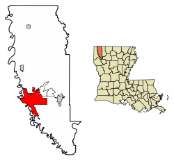 Location of Bossier City in Bossier Parish, Louisiana | |
 Bossier City Location of Bossier City in Bossier Parish, Louisiana  Bossier City Bossier City (the United States) | |
| Coordinates: 32°31′04″N 93°41′29″W | |
| Country | United States |
| State | Louisiana |
| Parishes | Bossier |
| Founded | 1907 |
| Named for | Pierre Bossier |
| Government | |
| • Mayor | Tommy Chandler[1] (R) |
| • City council | Members list |
| Area | |
| • City | 45.02 sq mi (116.60 km2) |
| • Land | 43.85 sq mi (113.57 km2) |
| • Water | 1.17 sq mi (3.03 km2) 1.89% |
| • Metro | 2,698 sq mi (6,987.8 km2) |
| Elevation | 174 ft (53 m) |
| Population (2020) | |
| • City | 62,701 |
| • Rank | BO: 1st LA: 7th |
| • Density | 1,429.90/sq mi (552.08/km2) |
| • Metro | 393,406 (US: 140th) |
| Time zone | UTC−6 (CST) |
| • Summer (DST) | UTC−5 (CDT) |
| Area code(s) | 318 |
| FIPS code | 22-08920 |
| Primary airport | Shreveport Regional Airport |
| Interstates | |
| Website | BossierCity.org |


Located on the eastern bank of the Red River, Bossier City is closely tied economically and socially to its larger sister city Shreveport on the opposite bank, though the city maintains its own community college (Bossier Parish Community College). Bossier City is the largest city in Louisiana that is not the parish seat.
History
19th century
In the 1830s, the area of Bossier City was the plantation Elysian Grove, which was purchased by James Cane and his second wife Mary Doal Cilley Bennett Cane.[6] James had come to the area with his first wife Rebecca Bennett, and her brother, William Bennett, and his wife Mary Doal Cilley Bennett. They ran a trading post across the river on what was then Caddo Indian territory, a portion called "Bennett's Bluff". The trading post partners became a 1/7 partner in the new Shreve Town, which eventually developed as Shreveport.
Elysian Grove plantation was located along the Red River for access to transportation, where the Texas Trail crossed the Red River. The trading post on the west side operated a ferry between what would become Shreveport and Bossier City. The plantation loading and unloading dock was later recorded as Cane's Landing in the old ferry log books.[7] For a very short time, Cane's Landing was known as Cane City.[8] The Canes and Bennetts were among the earliest settlers in the area. Mary D. C. Bennett gave birth to the first white baby of the area, William Smith Bennett Jr., who died at an early age.[9][10]
In 1843, a section of land east of the Red River was divided from the Great Natchitoches District and Claiborne Parish areas and was called Bossier Parish. It was named in honor of Pierre Evariste John Baptiste Bossier, a former Creole general, who became a cotton planter in Bossier Parish.[11] He was one of the first European settlers in the area.
In the 1840s, the Great Western Migration of Americans and immigrants began, and the parish grew in population. Many early settlers passed through the region on their way to the Western U.S. By 1850, more than 200 wagons a week passed through Bossier City, many intending to settle in Texas.[8] Some of these settlers stayed in Louisiana, attracted by the fertile soil and river valley. In 1850, the U.S. census listed the population at around 6,962.
American Civil War
During the American Civil War, companies of Confederate soldiers shipped out of Cane's Landing aboard steamboats for distant battlefields.[8] Mrs. Cane hosted hundreds of Confederate officers and troops who were heading off to war. Mrs. Cane's plantation was fortified to protect Shreveport by three batteries, with Fort Kirby Smith in the center. The others were Batteries Price, and Walker & Ewell.
Fort Smith protected the area from an eastern invasion.[8] The American Civil War reached Bossier Parish in 1861, and ended in Shreveport four years later, when the Trans-Mississippi Department surrendered. In the 20th century, Bossier High School was constructed near the former site of the fort.
Shed Road
Shed Road, the first all-weather turnpike in the American South, was constructed in the 1870s and operated from 1874 to 1886. It extended for 9 miles (14 km) from Red Chute to the Red River. There was a plantation at the end of the elevated and covered roadway, which was accessible by a ferry boat. The covered road made the transportation of goods easier before the arrival of the railroads.[6]
Classification as a city
Anna B., granddaughter of James and Mary Cane, felt the area would prosper and began promoting the idea of a riverfront city. Anna B. and J. J. Stockwell sold lots in 1883. The area grew quickly, as did transportation through it. At the time, the unincorporated settlement was often called Cane City. Around 1907, Cane City was incorporated by former Louisiana Governor Newton C. Blanchard and renamed the village of Bossier City. Blanchard named a Shreveport businessman, Ewald Max Hoyer, as the first Bossier City mayor. By that time, Bossier City had grown from an area of one square mile to a city containing more than 35 square miles (91 km2). Continued growth led to Bossier City's being re-designated from village to town by Governor John M. Parker. Later, Governor Earl Kemp Long issued a proclamation classifying Bossier City a city.[8]
The "golden spike" commemorated the completion of the east–west Vicksburg, Shreveport and Pacific Railroad. It was driven at Bossier City on July 12, 1884, by Julia "Pansy" Rule. It was the first such spike to be driven by a woman. The north–south Shreveport and Arkansas Railroad was completed on April 6, 1888. The Louisiana–Arkansas Railroad was completed on November 2, 1909.[12] The Dixie Overland Highway from the East to the West Coast was built in 1918. These railroads and highways combined to make Bossier City a hub for future activity.
The discovery of crude oil, to the south, in 1908, thrust Bossier City into the nationwide oil boom. Bossier's central location to the rural oil fields made it a major player in the oil patch. Several international oil companies were located in the area. The advantages brought by black gold fueled many civic, social and economic improvements.
A fire on June 23, 1925, consumed one-half of downtown Bossier City.[6] Local citizens were unable to battle the blaze. The loss spurred civic improvements including a modern water system capable of fighting such fires, a new city hall, a modern fire alarm system, modern sidewalks and the first city park.
In the 1930s, construction began on Barksdale Airfield (now Barksdale Air Force Base). The land on which the base is built was unincorporated property south of Bossier City in 1929. This land was annexed by the city of Shreveport and donated to the federal government. Through the years, Bossier City expanded, eventually encompassing the area surrounding the base. The first unit assigned to Barksdale was the 20th Pursuit Group. Before World War II, Barksdale was a training school for the Army Air Corps. During World War II, Barksdale trained pilots, navigators, and bombardiers. Later the base became one of the key bases of the Strategic Air Command in the new Air Force. Barksdale is the headquarters for the 8th Air Force.[13]
In the 1890s, Cane City had a population of about 600. Bossier City in 2012 had an estimated population of over 64,000. First a cotton-exporting river landing, next a railroad town, then an airbase and oil-boom town, Bossier City has become known for its tourism and casino gambling.[14]
Three casinos in the city have financed a number of municipal projects, many completed during the administration of the late Mayor George Dement. Recent improvements include the CenturyLink Center, Louisiana Boardwalk, Benton Road Overpass, and the Arthur Ray Teague Parkway, located along the eastern side of the Red River. Dement also procured Amtrak service between Bossier City and Dallas, Texas.[15] Dement was succeeded as mayor in 2005 by his administrative assistant and former mayoral opponent from 1989, Lo Walker, the first Republican to hold the city's top executive position.[16]
Growth and redevelopment
On April 20, 2017, in their joint "State of Bossier" address, hosted by the Bossier Chamber of Commerce, Mayor Lo Walker and Bossier Parish Police Jury President Bob Brotherton described the growth of the city and parish as "outstanding." With a population of 69,000 in a 2015 study by Louisiana State University, Bossier City had become the sixth-largest city in the state and the fastest-growing one.
Walker said that the city and the parish "work extremely close together, and our business and civic leaders and military make us an outstanding parish." The parish grew at 19 percent; the city grew at 10 percent. According to the Bossier Economic Development Foundation, the city could have reached 80,000 by 2019. Ongoing projects contributing to growth include the Walter O. Bigby Carriageway (the north parkway extension named for former state representative and judge Walter O. Bigby), Shed Road construction, and the South Bossier redevelopment districts.[17]
Geography
Bossier City is located at 32°31′4″N 93°41′29″W (32.517651, −93.691397) within the Ark-La-Tex[18] and has an elevation of 174 feet (53.0 m) above sea level.[19] The city lies primarily on the banks of the Red River, and has a largely flat topography in contrast with Shreveport's terrain. The northern city limits are noticeably more hilly than the rest of the city. Many small waterways flow through the city, such as Flat River and Red Chute Bayou, which provide drainage for many areas of the city.[20]
The city has a total area of 43.90 square miles (113.69 km2), of which 42.91 square miles (111.13 km2) is land and 0.99 square miles (2.56 km2) is water.[21]
Climate
Bossier shares most aspects of its climate with its sister city of Shreveport. The city has a humid subtropical climate (Köppen climate classification Cfa) with hot, humid summers and mild winters.
During the warmer months, the city is prone to severe thunderstorms which feature heavy rain, high winds, hail, and occasional tornadoes. The city has a slightly above average rate of tornadoes when compared to the U.S. average.[22] Due to the flat topography of the city and the prominence of smaller waterways that are prone to backwater flooding from the Red River, the city occasionally experiences severe flooding events. A notable occurrence of severe flooding occurred in March 2016 after torrential rains caused a rapid rise of many local waterways, displacing upwards of 3,500 people from their homes across the area.[23][24] Freezes and ice storms occasionally occur during the winter months.
| Climate data for Bossier City, Louisiana (Shreveport Regional Airport), 1981–2010 normals,[25] extremes 1871–present | |||||||||||||
|---|---|---|---|---|---|---|---|---|---|---|---|---|---|
| Month | Jan | Feb | Mar | Apr | May | Jun | Jul | Aug | Sep | Oct | Nov | Dec | Year |
| Record high °F (°C) | 85 (29) |
89 (32) |
92 (33) |
96 (36) |
102 (39) |
104 (40) |
108 (42) |
110 (43) |
109 (43) |
99 (37) |
88 (31) |
84 (29) |
110 (43) |
| Mean maximum °F (°C) | 76.1 (24.5) |
79.4 (26.3) |
84.4 (29.1) |
87.5 (30.8) |
92.2 (33.4) |
95.5 (35.3) |
99.4 (37.4) |
100.9 (38.3) |
97.2 (36.2) |
91.1 (32.8) |
82.6 (28.1) |
76.6 (24.8) |
101.8 (38.8) |
| Average high °F (°C) | 57.3 (14.1) |
61.5 (16.4) |
69.5 (20.8) |
76.9 (24.9) |
83.8 (28.8) |
90.1 (32.3) |
93.4 (34.1) |
94.1 (34.5) |
88.2 (31.2) |
78.2 (25.7) |
67.5 (19.7) |
58.5 (14.7) |
76.6 (24.8) |
| Average low °F (°C) | 36.2 (2.3) |
39.7 (4.3) |
46.3 (7.9) |
53.6 (12.0) |
62.7 (17.1) |
69.5 (20.8) |
72.7 (22.6) |
72.1 (22.3) |
65.6 (18.7) |
54.6 (12.6) |
45.2 (7.3) |
37.7 (3.2) |
54.7 (12.6) |
| Mean minimum °F (°C) | 20.3 (−6.5) |
24.6 (−4.1) |
29.6 (−1.3) |
37.4 (3.0) |
49.3 (9.6) |
60.7 (15.9) |
67.2 (19.6) |
64.8 (18.2) |
51.3 (10.7) |
38.3 (3.5) |
29.1 (−1.6) |
21.7 (−5.7) |
17.3 (−8.2) |
| Record low °F (°C) | −2 (−19) |
−5 (−21) |
15 (−9) |
31 (−1) |
39 (4) |
52 (11) |
58 (14) |
53 (12) |
42 (6) |
28 (−2) |
16 (−9) |
5 (−15) |
−5 (−21) |
| Average precipitation inches (mm) | 4.20 (107) |
4.75 (121) |
4.14 (105) |
4.19 (106) |
4.93 (125) |
5.40 (137) |
3.65 (93) |
2.73 (69) |
3.16 (80) |
4.96 (126) |
4.53 (115) |
4.77 (121) |
51.41 (1,305) |
| Average snowfall inches (cm) | 0.6 (1.5) |
0.5 (1.3) |
— | 0 (0) |
0 (0) |
0 (0) |
0 (0) |
0 (0) |
0 (0) |
0 (0) |
0 (0) |
0.3 (0.76) |
1.4 (3.6) |
| Average precipitation days (≥ 0.01 in) | 9.0 | 9.1 | 9.2 | 7.6 | 9.5 | 9.2 | 8.1 | 6.4 | 6.9 | 8.0 | 8.7 | 9.6 | 101.2 |
| Average snowy days (≥ 0.1 in) | 0.3 | 0.3 | 0.1 | 0 | 0 | 0 | 0 | 0 | 0 | 0 | 0 | 0.1 | 0.8 |
| Average relative humidity (%) | 72.6 | 69.7 | 67.7 | 69.6 | 73.2 | 73.3 | 72.4 | 71.7 | 73.6 | 71.7 | 73.7 | 74.4 | 72.0 |
| Mean monthly sunshine hours | 158.3 | 172.8 | 213.1 | 231.2 | 267.1 | 297.9 | 317.9 | 300.7 | 249.8 | 235.8 | 176.8 | 158.4 | 2,779.8 |
| Percent possible sunshine | 50 | 56 | 57 | 59 | 62 | 70 | 73 | 73 | 67 | 67 | 56 | 51 | 63 |
| Source: NOAA (sun and relative humidity 1961–1990)[26][27] | |||||||||||||
Demographics
| Historical population | |||
|---|---|---|---|
| Census | Pop. | %± | |
| 1890 | 202 | — | |
| 1910 | 775 | — | |
| 1920 | 1,094 | 41.2% | |
| 1930 | 4,003 | 265.9% | |
| 1940 | 5,786 | 44.5% | |
| 1950 | 15,470 | 167.4% | |
| 1960 | 32,776 | 111.9% | |
| 1970 | 43,769 | 33.5% | |
| 1980 | 50,817 | 16.1% | |
| 1990 | 52,721 | 3.7% | |
| 2000 | 56,461 | 7.1% | |
| 2010 | 61,315 | 8.6% | |
| 2020 | 62,701 | 2.3% | |
| U.S. Decennial Census[28] 2018 Estimate[29] | |||
| Race | Number | Percentage |
|---|---|---|
| White (non-Hispanic) | 31,843 | 50.79% |
| Black or African American (non-Hispanic) | 19,092 | 30.45% |
| Native American | 240 | 0.38% |
| Asian | 1,482 | 2.36% |
| Pacific Islander | 76 | 0.12% |
| Other/Mixed | 3,273 | 5.22% |
| Hispanic or Latino | 6,695 | 10.68% |
Per the 2020 United States census, there were 62,701 people, 26,677 households, and 17,524 families residing in the city.[30] According to 2019 census estimates per the American Community Survey, 24.2% of the population were aged 18 and older, and 13.8% were aged 65 and older; there were 26,927 households from 2015 to 2019, with an average of 2.44 people per household. In 1890, Bossier City initially had a population of 202, which has steadily increased since.
In 2019, the racial and ethnic makeup of the city was 58.5% non-Hispanic or Latino white, 27.9% Black or African American, 0.4% Native American, 2.4% Asian, 0.1% Native Hawaiian and other Pacific Islander, 2.5% two or more races, and 8.6% Hispanic and Latino American of any race.[31] At the 2020 census, the racial and ethnic makeup of the city was 50.79% non-Hispanic white, 30.45% Black or African American, 0.38% Native American, 2.36% Asian, 0.12% Pacific Islander, 5.22% two or more races, and 10.68% Hispanic and Latino American of any race; the 2020 census reflected nationwide trends of greater diversification and the growth of traditional minority populations in areas once predominantly non-Hispanic white.[32][33]
Of the 26,927 households estimated at 2019's American Community Survey, the owner-occupied housing rate was 52.8% and the median value of an owner-occupied housing unit was $163,500. The median cost with a mortgage was $1,182 versus $363 without a mortgage, and the median gross rent was $955. The median income for a household in the city was $50,340, and the per capita income was $26,755; an estimated 19.7% of the population lived at or below the poverty line. By 2020, its median household income was $48,385 with a mean income of $63,114.[34]
Religion
The majority of Bossier City's population is Christian,[35] and neighboring Shreveport is more religiously diverse than Bossier. Of its population, 37.9% identified as Baptists, primary affiliated with the Southern Baptist Convention and National Baptist Convention, USA, Inc. Within the city, 6.7% were Methodists primarily served by the United Methodist Church, 5.2% were Catholics in the Shreveport Diocese, 2.2% Pentecostal, 0.9% Latter-day Saints, 0.4% Presbyterian, 0.4% Lutheran, and 0.2% Episcopalian or Anglican. Within the Christian population of Bossier City, 7.7% claimed to be from another Christian group. Outside of Christendom, 0.3% of the city's residents were adherents to Islam.[35] Less than 0.1% of Bossier's residents identified with Judaism or eastern religions such as Hinduism or Buddhism.[35]
Education


Bossier City residents are zoned to Bossier Parish Schools.[36] Public schools in the area are listed below:
Elementary schools
- Apollo Elementary School
- Bellaire Elementary School
- Benton Elementary School
- Bossier Elementary School
- Carrie Martin Elementary School
- Central Park Elementary School
- Curtis Elementary School
- Elm Grove Elementary School
- Kingston Elementary School
- Legacy Elementary School
- Meadowview Elementary School
- Plantation Park Elementary School
- Platt Elementary School
- Princeton Elementary School
- T. L. Rhodes Elementary School
- R.V. Kerr Elementary School
- Stockwell Place Elementary School
- Sun City Elementary School
- W.T. Lewis Elementary School
- Waller Elementary School
Middle schools
- Benton Intermediate School
- Benton Middle School
- Cope Middle School
- Elm Grove Middle School
- Greenacres Middle School
- Haughton Middle School
- Plain Dealing Middle/High School
- T.O. Rusheon Middle School
High schools
- Airline High School
- Benton High School
- Bossier High School
- Haughton High School
- Parkway High School
- Plain Dealing High/Middle School
Community colleges
- Bossier Parish Community College
Universities
- Louisiana Tech University at Shreveport-Bossier City[37]
Media
As a sister city to Shreveport, the city of Bossier City is served by the Bossier Press-Tribune and Shreveport Times.[38] In addition, The Forum, City Lights, and SB Magazine are news magazines in the Shreveport–Bossier City area. The city shares the same television and radio markets with Shreveport and the Texarkana metropolitan area as part of the Ark-La-Tex.
In mainstream media, "Bossier City" is a song by David Allan Coe, in which he sings, "And it sure smells like snow in Bossier City..." Johnny Rodriguez recorded a song called "Achin' Bossier City Backyard Blues" in 1972. Turnpike Troubadours 2007 freshman album is entitled Bossier City, and includes the title track "Bossier City".
Radio
AM radio
| Callsign | Branding | Channel | Format |
|---|---|---|---|
| KRMD (AM) | Lite Rock 100.7 | 1340 | Soft AC |
FM radio
| Callsign | Branding | Channel | Format |
|---|---|---|---|
| KRUF | K94-5 | 94.5 | Top-40 |
| KVKI | 96.5 KVKI | 96.5 | Adult contemporary |
| KQHN | Q97.3 | 97.3 | Hot AC |
| KTUX | Highway 98.9 | 98.9 | Classic rock |
| KMJJ-FM | The Big Station | 99.7 | Urban |
| KRMD-FM | Country 101.1 | 101.1 | Country |
| KVMA-FM | Magic 102.9 | 102.9 | Urban AC |
Sports and entertainment

From the 1930s to the 1970s, Bossier was regionally and even nationally known for its entertainment district known as The Bossier Strip, which followed U.S. Highway 80 through the city. Nightclubs proliferated from the Texas Avenue Bridge to the Bossier-Webster parish line. Prior to the 1940s, The Strip was as well known for such entertainment as Las Vegas, Nevada.[39][40]
Bossier City and Shreveport share an all-women's flat track roller derby team named the Twin City Knockers. The team is the newest competing sport in the area, founded in January 2010. Bouts are hosted at Hot Wheels skating rink in south Bossier.
The Brookshires Grocery Arena (formerly CenturyTel Center) in Bossier City was the home of the Bossier–Shreveport Battle Wings of the AF2, as well as the Bossier-Shreveport Mudbugs of the Central Hockey League. The arena has hosted top performers, including Britney Spears and Aerosmith, as well as rodeos, ice shows, and children's entertainment.
The 2005 Red River Classic PRCA Rodeo to be hosted at the CenturyTel Center was cancelled due to the arena's use as a shelter for Hurricane Katrina evacuees.[41]
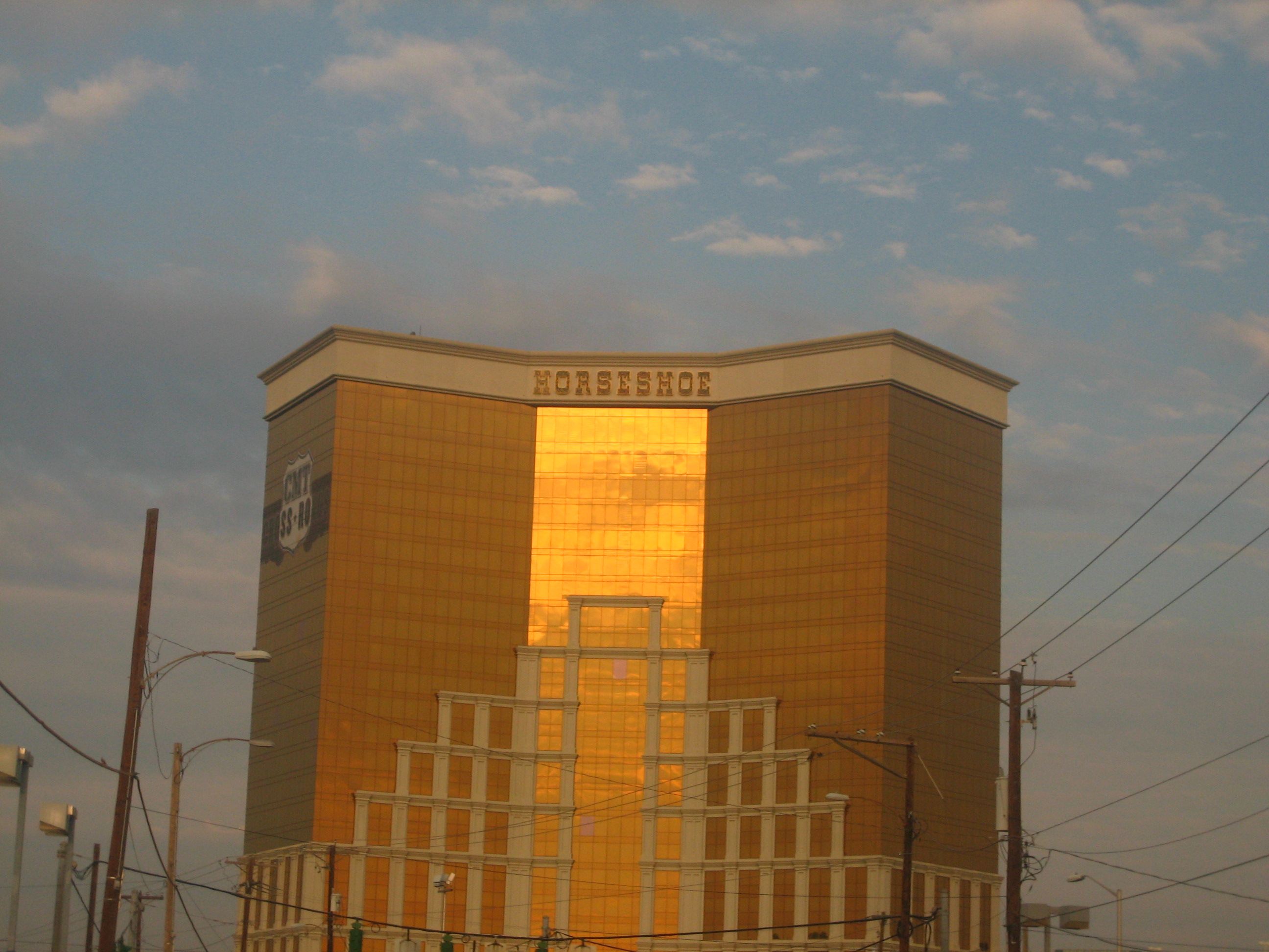
The city hosts three riverboat casino gambling resorts along the east bank of the Red River: Margaritaville, Horseshoe, and Boomtown. Diamond Jacks previously operated in the area before closing.[42] Horse racing and gambling on slot machines is also available at Louisiana Downs, which opened in 1974.
Notable people
- Robert E. "Bob" Barton, former member of the Louisiana House of Representatives (1996–2000)
- Sherry Boucher, former Hollywood actress and realtor in Bossier Parish
- Jimmy Boyd, state representative for Bossier Parish from 1944 to 1952
- Henry Newton Brown Jr., judge of the Louisiana Second Circuit Court of Appeals (1992–2012) and district attorney of Bossier and Webster parishes (1976–1991), is a long-term resident of Bossier City.
- Jeff Cox, judge of Division C of the 26th Judicial District in Bossier and Webster parishes since 2005[43]
- Raymond Crews, Republican state representative for District 8
- Tim Dement, amateur boxer who competed in the 1972 Summer Olympics, former Bossier City police detective, and son of former Mayor George Dement
- Ryan Gatti, state senator for District 36, 2016–2020; Bossier City lawyer[44]
- Eurlyne Howell, Miss Louisiana USA 1958, Miss USA 1958
- Mike Johnson, Republican U.S. Representative since 2017 for Louisiana's 4th congressional district; former state representative
- Donald Edward Jones, businessman who served as mayor of Bossier City from 1984 to 1989
- Keith Lehr, two-time World Series of Poker bracelet winner, born and resides in Bossier City
- Jared Leto, actor and musician, was born in Bossier City on December 26, 1971.
- Shannon Leto, drummer of 30 Seconds to Mars and older brother of Jared Leto, was born in Bossier City on March 9, 1970.
- Fred L. Lowery (born 1943), pastor of First Baptist Church of Bossier City, 1983–2013; Christian author
- Judi Ann Mason, born and reared in Shreveport-Bossier, Hollywood screenwriter and producer, wrote "Sister Act 2: Back in the Habit"
- John McConathy (1930–2016), professional basketball player, former superintendent for the Bossier Parish School Board
- Mike McConathy (born 1955), basketball coach at Northwestern State University in Natchitoches since 1999; former basketball coach at Bossier Parish Community College; son of John McConathy
- Alex Pourteau, professional wrestler who worked for both WWE and WCW, was born in Bossier City in 1969.
- Buddy Roemer, former United States Representative from Louisiana's 4th Congressional District (1980–87) and Governor of Louisiana (1988–92)
- Charles E. Roemer II, farmer, businessman, and politician
- B. J. Ryan was a closer in Major League Baseball for the Toronto Blue Jays of the American League. Previously, Ryan played for the Cincinnati Reds (1999) and Baltimore Orioles (1999–2005).
- Jeffrey D. Sadow, political scientist, columnist, professor at Louisiana State University in Shreveport
- Jeff R. Thompson, state representative; successor to Jane Smith
- David Toms, a professional golfer, graduated from Airline High School.
- Randy Walker, a professional American football player who played for the Green Bay Packers in 1974, graduated from Bossier High School and later Northwestern State University. Walker still holds many punting/kicking records at both schools.
- Todd Walker, a professional baseball player, graduated from Airline High School.
- Jesse Winchester, musician and songwriter, was born May 17, 1944, at Barksdale Air Force Base.
References
- Tommy Chandler takes oath of office as Bossier City's new mayor
- "2020 U.S. Gazetteer Files". United States Census Bureau. Retrieved March 20, 2022.
- "Bossier City, Louisiana (LA) profile: population, maps, real estate, averages, homes, statistics, relocation, travel, jobs, hospitals, schools, crime, moving, houses, news, sex offenders". www.city-data.com. Retrieved August 19, 2021.
- Office, US Census Bureau Public Information. "Census 2000 data for Louisiana". census.gov. Retrieved December 28, 2016.
- "QuickFacts: Bossier City, Louisiana". U.S. Census Bureau. Retrieved August 12, 2021.
{{cite web}}: CS1 maint: url-status (link) - "On the road: History of Bossier City". KSLA. Archived from the original on July 15, 2012. Retrieved August 19, 2021.
- LSUS Special Archives. Ferry Log Book.
- "City History | Bossier City, LA". www.bossiercity.org. Retrieved August 19, 2021.
- "Shreveport, LA – Official Website – History of Shreveport". ShreveportLa.gov. Retrieved December 28, 2016.
- "History". BossierCity.org. Archived from the original on February 6, 2015. Retrieved December 28, 2016.
- Carr, Jessica (April 27, 2018). "5 Fascinating Facts about the History of Bossier Parish". Be Bossier. Retrieved August 19, 2021.
- Smith, Chuck (October 8, 2018). "Do You Know the History of Bossier Railroads?". Be Bossier. Retrieved August 19, 2021.
- "8th Air Force".
- "Bossier City History". Archived from the original on September 5, 2008. Retrieved July 12, 2008.
- "Amanda Crane, "'Mr. Bossier' turns 91"". bossierpress.com. Retrieved February 6, 2013.
- "Lo Walker to seek third term as Bossier City mayor, April 12, 2012". KTBS-TV. Archived from the original on April 11, 2013. Retrieved February 3, 2013.
- Sarah Crawford (April 22, 2017). "Mayor: Bossier 6th largest city in state". The Shreveport Times. Retrieved April 24, 2017.
- "US Gazetteer files: 2010, 2000, and 1990". United States Census Bureau. February 12, 2011. Retrieved April 23, 2011.
- "US Board on Geographic Names". United States Geological Survey. October 25, 2007. Retrieved January 31, 2008.
- Bossier City (Louisiana). Bossier City Comprehensive Plan. Retrieved on 13 June 2016.
- "U.S. Census website". United States Census Bureau. Retrieved August 28, 2014.
- "Bossier City, Louisiana (LA) profile: population, maps, real estate, averages, homes, statistics, relocation, travel, jobs, hospitals, schools, crime, moving, houses, news, sex offenders". www.city-data.com. Retrieved June 13, 2016.
- Vagell, Quincy; Dolce, Chris; Erdman, Jon. "Over 23 Inches of Rain Triggers Historic Flash Flooding, River Flooding In Parts of the South". Retrieved March 11, 2016.[permanent dead link]
- "Flooding, evacuations continue in Caddo and Bossier parishes". shreveporttimes.com. Retrieved June 13, 2016.
- Mean monthly maxima and minima (i.e. the expected highest and lowest temperature readings at any point during the year or given month) calculated based on data at said location from 1981 to 2010.
- "NowData – NOAA Online Weather Data". National Oceanic and Atmospheric Administration. Retrieved August 22, 2019.
- "WMO Climate Normals for Shreveport/WSO AP, LA 1961–1990". National Oceanic and Atmospheric Administration. Retrieved February 12, 2017.
- United States Census Bureau. "Census of Population and Housing". Retrieved August 28, 2014.
- "Population Estimates". United States Census Bureau. Retrieved June 8, 2018.
- "Explore Census Data". data.census.gov. Retrieved December 29, 2021.
- "U.S. Census Bureau QuickFacts: Bossier City city, Louisiana". www.census.gov. Retrieved August 19, 2021.
- Frey, William H. (July 1, 2020). "The nation is diversifying even faster than predicted, according to new census data". Brookings. Retrieved May 27, 2022.
- "Census shows US is diversifying, white population shrinking". AP NEWS. August 12, 2021. Retrieved May 27, 2022.
- "Explore Census Data". data.census.gov. Retrieved May 27, 2022.
- "Bossier City, Louisiana Religion". www.bestplaces.net. Retrieved October 1, 2018.
- Bossier Parish Schools.
- "Home – Louisiana Tech University @ Shreveport – Bossier City". Archived from the original on May 28, 2013.
- Bossier Press-Tribune
- Kip Lornell and Tracey E. W. Laird, ed. (2008). Shreveport Sounds in Black and White. p. 151. ISBN 9781934110416. Retrieved January 20, 2015.
- "Las vegas casinos and past mob Ties". Archived from the original on June 13, 2010. Retrieved January 21, 2015.
- "2005 Red River Classic PRCA Rodeo Cancelled" (PDF). CenturyTel Center, 2005. Retrieved April 22, 2010.
- "DiamondJacks Casino & Hotel in Bossier City closes its doors, cites impact of COVID-19". KYTX. Retrieved May 16, 2020.
- "Judge Jeff Cox". 26jdc.com. Archived from the original on May 17, 2014. Retrieved April 26, 2014.
- "About Ryan". rayangatti.com. Archived from the original on May 7, 2016. Retrieved March 30, 2016.
External links
Municipalities and communities of Bossier Parish, Louisiana, United States | ||
|---|---|---|
Parish seat: Benton | ||
| Cities |  | |
| Towns | ||
| CDPs | ||
| Other communities |
| |
| Footnotes | ‡This populated place also has portions in an adjacent parish or parishes | |
| ||
City of Shreveport, Louisiana | |||||||
|---|---|---|---|---|---|---|---|
| Topics |
| ||||||
| Shreveport neighborhoods |
| ||||||
| Education |
| ||||||
| Transportation | |||||||
| Media |
| ||||||
| Landmarks |
| ||||||
| Culture |
| ||||||
See Ark-La-Tex and Shreveport/Bossier City Metro | |||||||
Baton Rouge (capital) | ||
| Topics |
|  Seal of Louisiana |
| Society |
| |
| Regions |
| |
| Cities |
| |
| CDPs | ||
| Metros |
| |
| Parishes |
| |
Authority control | |
|---|---|
| General | |
| National libraries | |
| Other |
|
На других языках
[de] Bossier City
Bossier City (fr.: Ville de Bossier) ist eine Stadt im Bossier Parish im Nordwesten des US-amerikanischen Bundesstaates Louisiana. Im Jahr 2020 hatte Bossier City 62.701 Einwohner.[1][2] Bossier City liegt gegenüber der größeren Stadt Shreveport am Red River und ist Bestandteil der Metropolregion Shreveport – Bossier City.- [en] Bossier City, Louisiana
Другой контент может иметь иную лицензию. Перед использованием материалов сайта WikiSort.org внимательно изучите правила лицензирования конкретных элементов наполнения сайта.
WikiSort.org - проект по пересортировке и дополнению контента Википедии