world.wikisort.org - USA
Plain Dealing is a town in Bossier Parish, Louisiana, United States. The population was 893 in 2020.[3] It is part of the Shreveport–Bossier City Metropolitan Statistical Area.
Plain Dealing, Louisiana | |
|---|---|
Town | |
| Town of Plain Dealing | |
 Leon Sanders, Jr., Municipal Complex | |
 Location of Plain Dealing in Bossier Parish, Louisiana. | |
 Location of Louisiana in the United States | |
| Coordinates: 32°54′21″N 93°42′0″W | |
| Country | |
| State | |
| Parish | Bossier |
| Government | |
| • Mayor[1] | Cindy Anderson Dodson (R) |
| Area | |
| • Total | 1.58 sq mi (4.10 km2) |
| • Land | 1.58 sq mi (4.09 km2) |
| • Water | 0.00 sq mi (0.01 km2) |
| Elevation | 266 ft (81 m) |
| Population (2020) | |
| • Total | 893 |
| • Rank | BO: 4th |
| • Density | 565.55/sq mi (218.41/km2) |
| Time zone | UTC-6 (CST) |
| • Summer (DST) | UTC-5 (CDT) |
| Area code | 318 |
| FIPS code | 22-60670 |
History
Prior to 1839, the United States government forcibly removed the Caddo Nation of Native Americans—longtime local inhabitants who had first settled the area over 1,000 years before Europeans' 16th-century arrival in mainland North America—from the area of Northern Louisiana that included the parcel that would later become the town of Plain Dealing.[4]
In 1839, George Oglethorpe Gilmer and his son, James Blair Gilmer, bought 5,000 acres of this land—now described as a "vast, unsettled wilderness"—from the United States government, calling a portion of this acreage "Plain Dealing" after the family's Virginia plantation.[4][5] The "Plain Dealing" name became official when the town was formally chartered on April 24, 1890.[4]
Notable points of more recent history include the following:
- Plain Dealing recorded the state's hottest temperature ever, 114 °F (46 °C), on August 10, 1936 (see "Climate" section below).
- The Plain Dealing Post newspaper was established in the 1980s by publisher Danny D. Scott of nearby Springhill.
- The Bossier Parish minimum security prison is located in Plain Dealing.
Geography
Plain Dealing is 8 miles (13 km) south of the Arkansas border and 31 miles (50 km) north of Shreveport.
According to the United States Census Bureau, the town has a total area of 1.6 square miles (4.1 km2), of which 0.004 square miles (0.01 km2), or 0.26%, is water.[6]
Climate
| Climate data for Plain Dealing, LA | |||||||||||||
|---|---|---|---|---|---|---|---|---|---|---|---|---|---|
| Month | Jan | Feb | Mar | Apr | May | Jun | Jul | Aug | Sep | Oct | Nov | Dec | Year |
| Record high °F (°C) | 85 (29) |
91 (33) |
93 (34) |
95 (35) |
99 (37) |
108 (42) |
111 (44) |
114 (46) |
107 (42) |
103 (39) |
94 (34) |
84 (29) |
114 (46) |
| Average high °F (°C) | 56.1 (13.4) |
60.1 (15.6) |
68.3 (20.2) |
76.4 (24.7) |
83.1 (28.4) |
90.6 (32.6) |
93.9 (34.4) |
94.2 (34.6) |
89.1 (31.7) |
79.3 (26.3) |
67.1 (19.5) |
58.2 (14.6) |
76.4 (24.7) |
| Average low °F (°C) | 34.1 (1.2) |
36.5 (2.5) |
43.4 (6.3) |
51.2 (10.7) |
59.6 (15.3) |
66.9 (19.4) |
70.1 (21.2) |
69.5 (20.8) |
63.7 (17.6) |
51.7 (10.9) |
41.7 (5.4) |
35.6 (2.0) |
52.0 (11.1) |
| Record low °F (°C) | −4 (−20) |
−14 (−26) |
13 (−11) |
26 (−3) |
35 (2) |
45 (7) |
52 (11) |
51 (11) |
36 (2) |
22 (−6) |
11 (−12) |
0 (−18) |
−14 (−26) |
| Average precipitation inches (mm) | 4.38 (111) |
3.79 (96) |
4.59 (117) |
4.88 (124) |
4.65 (118) |
4.01 (102) |
4.23 (107) |
3.04 (77) |
2.99 (76) |
3.44 (87) |
4.27 (108) |
4.79 (122) |
49.06 (1,245) |
| Average snowfall inches (cm) | 0.9 (2.3) |
0.5 (1.3) |
0.2 (0.51) |
0 (0) |
0 (0) |
0 (0) |
0 (0) |
0 (0) |
0 (0) |
0 (0) |
0.1 (0.25) |
0.6 (1.5) |
2.3 (5.86) |
| Source: https://wrcc.dri.edu/cgi-bin/cliMAIN.pl?la7344 | |||||||||||||
Demographics
| Historical population | |||
|---|---|---|---|
| Census | Pop. | %± | |
| 1900 | 258 | — | |
| 1910 | 474 | 83.7% | |
| 1920 | 655 | 38.2% | |
| 1930 | 1,412 | 115.6% | |
| 1940 | 1,085 | −23.2% | |
| 1950 | 1,321 | 21.8% | |
| 1960 | 1,357 | 2.7% | |
| 1970 | 1,300 | −4.2% | |
| 1980 | 1,213 | −6.7% | |
| 1990 | 1,074 | −11.5% | |
| 2000 | 1,071 | −0.3% | |
| 2010 | 1,015 | −5.2% | |
| 2020 | 893 | −12.0% | |
| U.S. Decennial Census[7] | |||
| Race | Number | Percentage |
|---|---|---|
| White (non-Hispanic) | 440 | 49.27% |
| Black or African American (non-Hispanic) | 414 | 46.58% |
| Other/Mixed | 22 | 2.46% |
| Hispanic or Latino | 15 | 1.68% |
As of the 2020 United States census, there were 893 people, 424 households, and 192 families residing in the town.[3]
Notable people
- William Benton Boggs (1854–1922), first mayor of Plain Dealing in 1890; member of the Louisiana House of Representatives from 1892 to 1900, and the Louisiana State Senate from 1908 to 1916[8]
- Mollie Burdett Banks Curry Gray (1862–1958), a Plain Dealing resident, was a great-great-grand-niece of George Washington. When she died in 1958 in Shreveport, she was listed as the oldest descendant of President Washington.
- Robert Houston Curry, first husband of Mollie Gray, was from 1888 to 1892 a member of the Louisiana House of Representatives for Bossier Parish.[9][10]
- John J. Doles (1895–1970), a business man and politician, member of the Louisiana State Senate from 1952 to 1956, and president of the Louisiana Bankers Association from 1956 to 1957
- John J. Doles, Jr. (1923–2004), Plain Dealing banker and civic leader
- Ryan Gatti (born 1974), state senator from Bossier City since 2016; owns a tree farm near Plain Dealing
- Booker T (born 1965), American professional wrestler and promoter.[11]
- A. P. Tugwell (1889–1976), born in Plain Dealing; the longest-serving Louisiana state treasurer
- Joseph David "Joe" Waggonner, Jr. (1918–2007), a former congressman; born in Plain Dealing and interred at Plain Dealing Cemetery.
- W. E. "Willie" Waggonner (1905–1976), sheriff of Bossier Parish from 1948 until his death in office; brother of Joe Waggonner
Gallery
 Plain Dealing corporate limits sign
 Downtown Plain Dealing
 Gazebo in downtown Plain Dealing
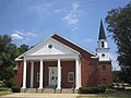 Plain Dealing Baptist Church of Plain Dealing
 First United Methodist Church of Plain Dealing
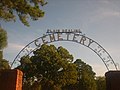 The Plain Dealing Cemetery contains the graves of former U.S. Representative Joe D. Waggonner and Waggonner's older brother, former Bossier Parish Sheriff Willie E. Waggonner.


References
- (PDF) https://www.bossierchamber.com/wp-content/uploads/2018/07/Bossier-Parish-candidates.pdf. Retrieved 17 March 2019.
{{cite web}}: Missing or empty|title=(help) - "2020 U.S. Gazetteer Files". United States Census Bureau. Retrieved March 20, 2022.
- "Explore Census Data". data.census.gov. Retrieved 2021-12-29.
- James A. Marples (2015-03-31). "Finding 'real deal' in Plain Dealing". Shreveporttimes.com. Retrieved 2016-02-06.
- "MY HOMETOWN : PLAIN DEALING, LOUISIANA". Webcitation.org. Archived from the original on August 3, 2001. Retrieved 2016-02-06.
{{cite web}}: CS1 maint: unfit URL (link) - "Geographic Identifiers: 2010 Demographic Profile Data (G001): Plain Dealing town, Louisiana". U.S. Census Bureau, American Factfinder. Archived from the original on February 12, 2020. Retrieved December 3, 2013.
- "Census of Population and Housing". Census.gov. Retrieved June 4, 2015.
- "My Hometown: Plain Dealing, Louisiana". oocities.org. Retrieved March 23, 2015.
- "Oldest Descendant Of First President Succumbs At 93". The Monroe News-Star. Monroe, Louisiana. May 19, 1958. p. 7. Retrieved July 24, 2015.
- "Curry, Robert H." The Political Graveyard. Retrieved July 24, 2015.
- Huffman, Booker T with Andrew William Wright (2012). Booker T: From Prison to Promise: Life Before the Squared Circle. Aurora, Ill: Medallion Press. ISBN 978-1605424682.
Municipalities and communities of Bossier Parish, Louisiana, United States | ||
|---|---|---|
Parish seat: Benton | ||
| Cities | 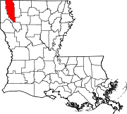 | |
| Towns | ||
| CDPs | ||
| Other communities |
| |
| Footnotes | ‡This populated place also has portions in an adjacent parish or parishes | |
| ||
Authority control | |
|---|---|
| General | |
| National libraries | |
На других языках
[de] Plain Dealing
Plain Dealing ist eine Kleinstadt (mit dem Status „Town“) im Bossier Parish im US-amerikanischen Bundesstaat Louisiana. Im Jahr 2010 hatte Plain Dealing 1015 Einwohner.[1]- [en] Plain Dealing, Louisiana
Другой контент может иметь иную лицензию. Перед использованием материалов сайта WikiSort.org внимательно изучите правила лицензирования конкретных элементов наполнения сайта.
WikiSort.org - проект по пересортировке и дополнению контента Википедии