world.wikisort.org - USA
Anderson is a city in and the county seat of Anderson County, South Carolina, United States.[4] The population was 28,106 at the 2020 census,[5] and the city was the center of an urbanized area of 75,702.[6] It is one of the principal cities in the Greenville-Anderson-Mauldin metropolitan statistical area, which had a population of 824,112 at the 2010 census. It is further included in the larger Greenville-Spartanburg-Anderson, South Carolina combined statistical area, with a total population of 1,266,995, at the 2010 census. It is just off Interstate 85 and is 120 miles (190 km) from Atlanta and 140 miles (230 km) from Charlotte. Anderson is the smallest of the three primary cities that make up the Upstate region, and is nicknamed the "Electric City" and the "Friendliest City in South Carolina". Anderson is the home of Anderson University, a private university with roughly 3,900 undergraduate and graduate students.
Anderson | |
|---|---|
City | |
| City of Anderson | |
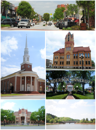 Top, left to right: Downtown Anderson, First Baptist Church of Anderson, Old Anderson County Courthouse, Anderson University, Anderson County Courthouse and Confederate Monument, Lake Hartwell view from City of Anderson Recreation Park | |
 Seal | |
| Motto: "The Electric City" | |
 Location of Anderson, South Carolina | |
 Anderson  Anderson  Anderson | |
| Coordinates: 34°30′52″N 82°38′56″W | |
| Country | United States |
| State | South Carolina |
| County | Anderson |
| Named for | Robert Anderson |
| Government | |
| • Type | Council-manager government |
| • Mayor | Terence Roberts |
| • City Manager | David McCuen |
| Area | |
| • Total | 15.87 sq mi (41.09 km2) |
| • Land | 15.83 sq mi (41.00 km2) |
| • Water | 0.04 sq mi (0.10 km2) |
| Elevation | 807 ft (246 m) |
| Population (2020)[3] | |
| • Total | 28,106 |
| • Density | 1,775.60/sq mi (685.56/km2) |
| ZIP Codes | 29621-29626 |
| FIPS code | 45-01360 |
| GNIS feature ID | 2403098[2] |
| Website | www |
History
Anderson Court House

Cherokee first settled the area of what is today the city of Anderson. During the American Revolution, the Cherokee sided with the British. After the American Revolutionary War, the Cherokee's land was acquired as war reparations and colonized. In 1791, the South Carolina Legislature created the Washington District, which comprised Greenville, Anderson, Oconee, and Pickens Counties. The Washington District was then divided into Greenville and Pendleton districts. Anderson, Pickens, and Oconee comprised the newly created Pendleton district. Anderson was settled in 1826 and incorporated in 1828 as Anderson Court House, separate from the Pendleton district. The name Anderson is in honor of Robert Anderson, who fought in the American Revolutionary War and also explored the Anderson region in the mid-18th century. Anderson District (later Anderson County after 1867) was also established in 1826 out of the Pendleton district.
In 1851, the Johnson Female Seminary was established in Anderson as the first college of the town, and was named after William Bullein Johnson. One year later, the seminary was renamed Johnson University.[7] During the American Civil War, Johnson University was closed and converted into a Confederate treasury. On May 1, 1865, Union forces invaded Anderson looking for the Confederate treasury. The treasury office of Anderson was ransacked by Union forces, and the main building of Johnson University was used as a Union headquarters. A minor skirmish erupted at the Battle of Anderson, leading to two Union casualties.[8] After the war, a Union garrison was stationed in Anderson.
The Electric City

Anderson became one of the first cities in the Southeastern United States to have electricity. Electricity to Anderson was established by William C. Whitner in 1895 at a hydroelectric plant on the Rocky River, giving the city the name the Electric City. Anderson also became the first city in the world to supply a cotton gin by electricity. In 1895, Anderson Court House was renamed to Anderson.[9][10] In 1897, Whitner's plant was upgraded with a 10,000-volt generating station at Portman Shoals. Whitner's power plant at Portman Shoals became the first hydroelectric plant in the United States to generate high voltage without step-up transformers .[11] The Portman Dam was swept away in 1901, forcing Anderson into darkness until it was rebuilt in 1902.[12]
Anderson College
In 1911, Anderson College was established by the Anderson Chamber of Commerce. Anderson College was a successor to the Johnson Female Seminary and is affiliated with the South Carolina Baptist Convention, in particular the First Baptist Church of Anderson. Anderson College became a co-educational, two-year junior college in 1930, and in 2006, it became Anderson University.[13]
Geography

Anderson is located in the northwest corner of South Carolina on the Piedmont plateau. Anderson is a 1-hour drive from the Blue Ridge Mountains and a 4-hour drive from the South Carolina coast. Anderson lies roughly at the midpoint of the busy I-85 corridor between Atlanta and Charlotte.
According to the United States Census Bureau, the city has a total area of 14.6 square miles (37.9 km2), of which 0.039 square miles (0.1 km2), or 0.30%, is covered by water.[14]
Cityscape

Historic districts
- Anderson College Historic District
- Anderson Downtown Historic District
- Anderson Historic District
- McDuffie Street Historic District
- South Boulevard Historic District
- Westside Historic District
- Whitner Street Historic District
- Other historical locations
- Caldwell-Johnson-Morris Cottage
- Denver Downs Farmstead
- Kennedy Street School
- North Anderson Historic District
- Dr. Samuel Marshall Orr House
- Ralph John Ramer House
Parks
- Anderson Memorial Stadium — A ballfield/stadium on 12 acres (4.9 ha) of land on White Road, it was renovated in 2007 with stadium-style seating. It is home to the Anderson University Trojans.
- Anderson Sports and Entertainment Center — A 300-acre (120 ha) area, it includes the Anderson Civic Center, a 37,000-square-foot (3,400 m2) facility, as well as one of South Carolina's largest amphitheaters that can accommodate 15,000 people, a huge castle-like play structure with play equipment, a 64-acre (26 ha) sports center with seven baseball/softball fields, three soccer fields, a disc golf course, and eight tennis courts. The lake has a park, picnic shelters, and miles of nature trail. The center is Anderson's largest recreational area.
Economy
Anderson is home to the largest Glen Raven, Inc. manufacturing center facility, which focuses on manufacturing Sunbrella fabrics.[15] Anderson's economy revolves around manufacturing. It has over 230 manufacturers, including 22 international companies. In the county, Anderson has a thriving business climate. Its top major industries include manufacturers of automotive products, metal products, industrial machinery, plastics, publishing, and textiles. Two industries that many times interconnect are the plastic and automotive sectors. More than 27 BMW suppliers are the Upstate region, which is recognized internationally as an automotive supplier hub. The plastics industry has a strong presence in the Upstate, with 244 plastic companies located within the 10 counties of the state's northwest corner. Anderson County, in particular, has 11 automotive suppliers, and is a major player in the plastic industry, with 27 plastics companies located within its borders.[16][17]
Hospitals
AnMed Health is one of the top employers in the county, and the primary healthcare network for Anderson. AnMed Health Medical Center is the main medical facility, offering all the amenities of a standard hospital, as well as a heart and vascular center, and stroke/neurological center. Located 2.5 miles north of the facility is the AnMed Health Campus, which includes a women's and children's hospital, minor care, cancer center, speech and occupational therapy, and more. The AnMed Rehabilitation Hospital is located between the two facilities. AnMed has recently received national attention being awarded the "National Presidents Circle Award," and the "American College of Cardiology Foundation’s 2012 NCDR ACTION Registry–GWTG Platinum Performance Achievement Award."
In addition to these three network hospitals, AnMed also operates a number of smaller facilities throughout the city and county that range from a free clinic and minor care to doctor's offices.
Education
The city of Anderson is served by the Anderson County School System (specifically, Anderson School District Five). The school district has 11 elementary schools, five middle schools, and two high schools.
Elementary schools:
- Calhoun Academy of the Arts
- Centerville Elementary
- Concord Elementary
- Homeland Park Primary School
- McLees Academy of Leadership
- Midway Elementary School of Science and Engineering
- Nevitt Forest Community School of Innovation
- New Prospect STEM Academy
- North Pointe Elementary School
- Varennes Academy of Communications and Technology
- Whitehall Elementary, A Global Communication School
Middle schools:
- McCants Middle School
- Southwood Academy of the Arts
- Robert Anderson Middle School
- Glenview Middle School

High schools:
- Westside High School
- T. L. Hanna High School
- Anderson Five Career Campus
Private schools:
- Anderson Christian School
- Boulevard Child Enrichment Center
- Day Star School
- First Presbyterian Church Day School
- Grace Kindergarten
- Montessori School of Anderson
- New Covenant School
- Learn Upstate LLC
- Oakwood Christian School
- St Joseph Catholic School
- Temple Christian Academy
- West Anderson Christian Academy
Higher education
- Anderson University
- Tri-County Technical College
Library
Anderson has a public library, a branch of the Anderson County Library System.[18]
Transportation
Airport
Anderson is served by Anderson County Regional Airport (IATA: AND, ICAO: KAND). The airport is 3 miles (4.8 km) away from Anderson and has 2 runways; runway 5/23 is 6,000 feet (1,800 m) and runway 17/35 is 5,000 feet (1,500 m). The airport also has helipads. The airport has no control tower, but is able to accommodate regional jet aircraft. In addition, the airport has a small terminal.
Roads and highways
Anderson has five signed exits on I-85, currently the city's only freeway. Several notable highways pass through the city, including U.S. Route 76 and U.S. Route 178 co-signed along Clemson Boulevard, also known as SC-Bus 28, and U.S. Route 29 and Route 187 leading to Hartwell, Georgia, to the south and Greenville to the north.
In 2011, construction began on a new east–west connector that is about 3 mi long between Clemson Boulevard and South Carolina Highway 81.[19] On August 16, 2010, the connector was voted to have four lanes with turn and bike lanes, and a completion date set in October 2012.[20]
On November, 8th, 2013, the East-West Parkway formally opened to traffic.
Public transit
Anderson has four bus routes (Blue, Green, Red, and Gold) that travel to most major areas of the city, running every hour.[21] and also receives service from Clemson Area Transit (CATS) via the 4U route.[22] The city uses both newer hybrid buses and older style trolleys resembling Anderson's old streetcars. Inter-city bus travel is available through Greyhound Lines, located on West Whitner Street near downtown.
One of the Southeast High Speed Rail Corridor alternatives for a Charlotte - Greenville - Atlanta route includes a stop at Anderson.[23][24] This would mark the first time that passenger rail reached Anderson, since the passing of Piedmont and Northern Railway in ca. 1947[25][26] and the Blue Ridge Railway in ca. 1951 from Anderson.[27][28]
Demographics
| Historical population | |||
|---|---|---|---|
| Census | Pop. | %± | |
| 1860 | 625 | — | |
| 1870 | 1,432 | 129.1% | |
| 1880 | 1,850 | 29.2% | |
| 1890 | 3,018 | 63.1% | |
| 1900 | 5,498 | 82.2% | |
| 1910 | 9,654 | 75.6% | |
| 1920 | 10,570 | 9.5% | |
| 1930 | 14,383 | 36.1% | |
| 1940 | 19,424 | 35.0% | |
| 1950 | 19,770 | 1.8% | |
| 1960 | 41,316 | 109.0% | |
| 1970 | 27,556 | −33.3% | |
| 1980 | 27,546 | 0.0% | |
| 1990 | 26,184 | −4.9% | |
| 2000 | 25,514 | −2.6% | |
| 2010 | 26,686 | 4.6% | |
| 2020 | 28,106 | 5.3% | |
| 2021 (est.) | 29,284 | [5] | 4.2% |
| U.S. Decennial Census[3] | |||
2020 census
| Race | Num. | Perc. |
|---|---|---|
| White (non-Hispanic) | 16,392 | 58.32% |
| Black or African American (non-Hispanic) | 8,276 | 29.45% |
| Native American | 46 | 0.16% |
| Asian | 416 | 1.48% |
| Pacific Islander | 5 | 0.02% |
| Other/Mixed | 1,222 | 4.35% |
| Hispanic or Latino | 1,749 | 6.22% |
As of the 2020 United States census, there were 28,106 people, 11,412 households, and 6,112 families residing in the city.
2000 census
At the census[30] of 2000, 25,514 people, 10,641 households, and 6,299 families were residing in the city. The population density was 1,843.7 people/sq mi (711.8/km2). The 12,068 housing units averaged 872.1/sq mi (336.7/km2). The racial makeup of the city was 63.12% White, 34.01% African American, 0.22% Native American, 0.78% Asian American, 0.72% from other races, and 1.16% from two or more races. Hispanics or Latinos of any race were 1.48% of the population.
Of the 10,641 households, 25.4% had children under 18 living with them, 36.9% were married couples living together, 18.7% had a female householder with no husband present, and 40.8% were not families. About 36.0% of all households were made up of individuals, and 16.3% had someone living alone who was 65 or older. The average household size was 2.22, and the average family size was 2.89.
In the city, the age distribution was 22.2% under 18, 10.7% from 18 to 24, 26.3% from 25 to 44, 20.4% from 45 to 64, and 20.4% who were 65 or older. The median age was 38 years. For every 100 females, there were 82.3 males. For every 100 females age 18 and over there were 77.5 males.
Anderson is the central city of an urbanized area with a total population of 70,530 (2000 census). This urban area is within the larger Greenville-Spartanburg metropolitan statistical area.
Government
Anderson is governed using the mayor-council system. The mayor is elected at-large. The city council consists of eight members; six are elected from districts and the other two are elected at-large.
Notable people
- Kip Anderson, Southern soul and blues artist, recorded his first record on Vee Jay Records. The Beatles first recorded on the Vee Jay label. His last job was a DJ at WANS radio in Anderson.
- Chadwick Boseman (1976–2020), actor (Black Panther, 42, Get on Up, Captain America: Civil War, Avengers: Endgame)[31]
- Lou Brissie, Major League Baseball player with Philadelphia Athletics and Cleveland Indians from 1947 to 1953
- Milford Burriss, state legislator
- Yung Carter, record producer[32]
- Guy Davenport, novelist, poet, and scholar
- Shaun Ellis, professional football player
- Bailey Hanks, winner of MTV's Legally Blonde the Musical: The Next Elle Woods
- Brandon Micheal Hall, actor (God Friended Me)
- Preston Jones, professional football player[33]
- James "Radio" Kennedy, the movie Radio was based on his life with T.L. Hanna High School in Anderson, SC.
- Rafael Little, professional football player, Canadian Football League
- Johnny Mann, arranger, composer, conductor, entertainer, and recording artist; honorary alumnus (D. Hum.) from Anderson University
- Adam Minarovich, actor, screenwriter and film director.
- Charles Murphey (1799–1861), United States congressman from Georgia[34]
- Larry Nance, retired NBA basketball player with the Phoenix Suns and Cleveland Cavaliers, three-time All-Star
- James Lawrence Orr, former governor of South Carolina and speaker of the United States House of Representatives
- Lu Parker, Miss South Carolina USA 1994, Miss USA 1994, television personality and journalist
- Wesley Quinn, dancer/singer in popular boy band V Factory
- Jim Rice, professional baseball player with Boston Red Sox from 1974 to 1989, member of National Baseball Hall of Fame, class of 2009
- Terence Roberts, first African-American mayor of Anderson[35]
- Jessica Stroup, actress on television series 90210 and The Following
- Jack Swilling, generally recognized as the pioneer founder of Phoenix, Arizona
- Ben Taylor, Negro league professional baseball player from 1908 to 1929, manager/coach from 1929 to 1940, member of National Baseball Hall of Fame, Class of 2006
- Candy Jim Taylor, Negro league professional baseball player and manager[36]
- Steel Arm Johnny Taylor, Negro league professional baseball player[37]
- George Webster, former AFL and NFL football player, two-time All American at Michigan State University, 1965–66
Sister cities
Anderson has two sister cities, as designated by Sister Cities International:[38]
 Carrickfergus, County Antrim, Northern Ireland, United Kingdom
- Comhairle nan Eilean Siar, Scotland, UK
References
- "ArcGIS REST Services Directory". United States Census Bureau. Retrieved October 15, 2022.
- U.S. Geological Survey Geographic Names Information System: Anderson, South Carolina
- "Census Population API". United States Census Bureau. Retrieved Oct 15, 2022.
- "Find a County". National Association of Counties. Archived from the original on 2011-05-31. Retrieved 2011-06-07.
- "Population and Housing Unit Estimates". United States Census Bureau. July 1, 2021. Retrieved August 2, 2022.
- "Geographic Identifiers: 2010 Census Summary File 1 (G001): Anderson, SC Urbanized Area (2010)". U.S. Census Bureau, American Factfinder. Archived from the original on February 12, 2020. Retrieved August 7, 2013.
- "Johnson Female Seminary". The Abbeville Banner. January 29, 1851.
- "Area schools affected by Civil War". Independent Mail. July 5, 2014. Retrieved 20 November 2016.
- "History of Anderson, South Carolina". u-s-history.com.
- "Anderson: "The Electric City"". Retrieved 9 February 2016.
- "The South Carolina man who put the electric in "The Electric City"". Appalachianhistory.net. Archived from the original on 2016-11-20. Retrieved 20 November 2016.
- "Portman Dam and Power Plant Historical Marker". www.hmdb.org. Retrieved 2022-11-06.
- "Anderson University - Anderson, South Carolina". Sciway.net. Retrieved 20 November 2016.
- "Geographic Identifiers: 2010 Demographic Profile Data (G001): Anderson city, South Carolina". U.S. Census Bureau, American Factfinder. Archived from the original on February 12, 2020. Retrieved August 7, 2013.
- "Glen Raven expanding Anderson County Sunbrella® manufacturing center". South Carolina Department of Commerce. Retrieved 22 July 2021.
- "Manufacturing in Anderson County - Anderson Area Chamber of Commerce - Anderson, SC, SC". www.andersonscchamber.com. Retrieved 2022-11-06.
- "Plastic Omnium expanding operations in Anderson County | South Carolina Department of Commerce". www.sccommerce.com. Retrieved 2022-11-06.
- "South Carolina libraries and archives". SCIWAY. Retrieved 7 June 2019.
- "News – City of Anderson, SC". Cityofandersonsc.com. Archived from the original on 2014-06-27. Retrieved 2014-06-26.
- Foster, Kisha (2010-08-17). "4-Lanes Approved For East-West Connector | WYFF Home - WYFF Home". Wyff4.com. Archived from the original on 2012-03-23. Retrieved 2014-06-26.
- [dead link]
- "Clemson Area Transit - Anderson Route". Catbus.com. Archived from the original on 2014-06-27. Retrieved 2014-06-26.
- "Atlanta to Charlotte Passenger Rail Corridor Investment Plan - Alternatives Development Report". Atlanta, Georgia: Georgia Department of Transportation. October 2015. Retrieved October 19, 2019.
- Henderson, Bruce (October 18, 2019). "High-speed rail could link Charlotte to Atlanta in 2 hours. Have your say next week". The Charlotte Observer. Retrieved October 19, 2019.
- "Piedmont and Northern Railway". Official Guide of the Railways. National Railway Publication Company. 78 (12). May 1946.
- "Piedmont and Northern Railway, freight only branch; reporting from June 1, 1947 timetable". Official Guide of the Railways. National Railway Publication Company. 80 (11). April 1948.
- "Blue Ridge Railway". Official Guide of the Railways. National Railway Publication Company. 82 (3). August 1949.
- "Carolina and Northwestern Railway, 'Belton and Walhalla (Anderson Division)', freight only". Official Guide of the Railways. National Railway Publication Company. 84 (7). December 1951.
- "Explore Census Data". data.census.gov. Retrieved 2021-12-14.
- "U.S. Census website". United States Census Bureau. Retrieved 2008-01-31.
- Gilbey, Ryan (29 August 2020). "Chadwick Boseman obituary". The Guardian. Retrieved 29 August 2020.
- "Yung Carter's Profile On Beat Making Videos". Retrieved 2015-01-30.
- "Former Hanna QB Preston Jones returns to alma mater as receivers coach". independentmail.com. July 19, 2012. Archived from the original on December 19, 2014. Retrieved November 17, 2014.
- Who Was Who in America, Historical Volume, 1607-1896. Chicago: Marquis Who's Who. 1963.
- "Anderson mayor released from hospital after aneurysm". WRDW-TV. July 12, 2017.
- "Negro Leagues Baseball eMuseum: Personal Profiles: "Candy Jim" Taylor". www.nlbemuseum.com. Retrieved 2020-08-20.
- "Negro Leagues Baseball eMuseum: Personal Profiles: "Steel Arm Johnny" Taylor". www.nlbemuseum.com. Retrieved 2020-08-20.
- "Archived copy". Archived from the original on 2017-02-07. Retrieved 2017-02-06.
{{cite web}}: CS1 maint: archived copy as title (link)
External links
Municipalities and communities of Anderson County, South Carolina, United States | ||
|---|---|---|
County seat: Anderson | ||
| Cities | 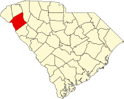 | |
| Towns | ||
| CDPs | ||
| Other communities | ||
| Footnotes | ‡This populated place also has portions in an adjacent county or counties | |
| ||
Authority control | |
|---|---|
| General | |
| National libraries | |
| Other |
|
На других языках
[de] Anderson (South Carolina)
Anderson ist eine Stadt im und gleichzeitig der County Seat des Anderson County im US-amerikanischen Bundesstaat South Carolina. Das U.S. Census Bureau hat bei der Volkszählung 2020 eine Einwohnerzahl von 28.106[2] ermittelt. Anderson liegt im Nordwesten South Carolinas an der Interstate 85 zwischen Charlotte (ca. 210 km) und Atlanta (ca. 200 km).- [en] Anderson, South Carolina
Другой контент может иметь иную лицензию. Перед использованием материалов сайта WikiSort.org внимательно изучите правила лицензирования конкретных элементов наполнения сайта.
WikiSort.org - проект по пересортировке и дополнению контента Википедии