world.wikisort.org - USA
Northlake is a census-designated place (CDP) in Anderson County, South Carolina, United States. The population was 3,745 at the 2010 census.[5]
Northlake, South Carolina | |
|---|---|
Census-designated place | |
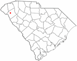 Location of Northlake, South Carolina | |
| Coordinates: 34°33′46″N 82°41′25″W | |
| Country | United States |
| State | South Carolina |
| County | Anderson |
| Area | |
| • Total | 5.20 sq mi (13.46 km2) |
| • Land | 4.14 sq mi (10.72 km2) |
| • Water | 1.06 sq mi (2.74 km2) |
| Elevation | 656 ft (200 m) |
| Population (2020)[3] | |
| • Total | 3,818 |
| • Density | 922.67/sq mi (356.24/km2) |
| Time zone | UTC-5 (Eastern (EST)) |
| • Summer (DST) | UTC-4 (EDT) |
| FIPS code | 45-51180[4] |
| GNIS feature ID | 1867527[2] |
Geography
Northlake is a suburban area located in central Anderson County at 34°33′46″N 82°41′25″W (34.562912, -82.690145),[6] bordering the north side of Anderson, the county seat. The CDP on both sides of an arm of Lake Hartwell, a large reservoir and recreation area. Interstate 85 forms the northern boundary of the CDP, leading northeast 27 miles (43 km) to Greenville and southwest 120 miles (190 km) to Atlanta. Exits 19 (U.S. Route 76) and 21 (U.S. Route 178) serve the community.
According to the United States Census Bureau, the CDP has a total area of 5.2 square miles (13.4 km2), of which 4.1 square miles (10.7 km2) is land and 1.0 square mile (2.7 km2), or 20.42%, is water.[5] Darwin Wright Park, a City of Anderson recreation area, provides access within the CDP to Lake Hartwell on its arm formed by Six and Twenty Creek.
Demographics
| Historical population | |||
|---|---|---|---|
| Census | Pop. | %± | |
| 2020 | 3,818 | — | |
| U.S. Decennial Census[7] | |||
2020 census
| Race | Num. | Perc. |
|---|---|---|
| White (non-Hispanic) | 3,121 | 81.74% |
| Black or African American (non-Hispanic) | 366 | 9.59% |
| Native American | 3 | 0.08% |
| Asian | 87 | 2.28% |
| Pacific Islander | 2 | 0.05% |
| Other/Mixed | 143 | 3.75% |
| Hispanic or Latino | 96 | 2.51% |
As of the 2020 United States census, there were 3,818 people, 1,530 households, and 1,085 families residing in the CDP.
2000 census
As of the census[4] of 2000, there were 3,659 people, 1,611 households, and 1,089 families residing in the CDP. The population density was 862.7 people per square mile (333.2/km2). There were 1,775 housing units at an average density of 418.5/sq mi (161.6/km2). The racial makeup of the CDP was 90.90% White, 6.81% African American, 0.16% Native American, 1.28% Asian, 0.16% from other races, and 0.68% from two or more races. Hispanic or Latino of any race were 0.52% of the population.
There were 1,611 households, out of which 24.6% had children under the age of 18 living with them, 59.7% were married couples living together, 5.5% had a female householder with no husband present, and 32.4% were non-families. 28.5% of all households were made up of individuals, and 7.7% had someone living alone who was 65 years of age or older. The average household size was 2.26 and the average family size was 2.78.
In the CDP, the population was spread out, with 19.9% under the age of 18, 7.8% from 18 to 24, 28.3% from 25 to 44, 28.5% from 45 to 64, and 15.5% who were 65 years of age or older. The median age was 41 years. For every 100 females, there were 97.5 males. For every 100 females age 18 and over, there were 97.1 males.
The median income for a household in the CDP was $51,371, and the median income for a family was $62,415. Males had a median income of $44,236 versus $30,125 for females. The per capita income for the CDP was $28,912. About 1.4% of families and 3.2% of the population were below the poverty line, including 1.5% of those under age 18 and 4.7% of those age 65 or over.
References
- "ArcGIS REST Services Directory". United States Census Bureau. Retrieved October 15, 2022.
- U.S. Geological Survey Geographic Names Information System: Northlake, South Carolina
- "Census Population API". United States Census Bureau. Retrieved Oct 15, 2022.
- "U.S. Census website". United States Census Bureau. Retrieved 2008-01-31.
- "Geographic Identifiers: 2010 Demographic Profile Data (G001): Northlake CDP, South Carolina". U.S. Census Bureau, American Factfinder. Archived from the original on February 12, 2020. Retrieved August 8, 2013.
- "US Gazetteer files: 2010, 2000, and 1990". United States Census Bureau. 2011-02-12. Retrieved 2011-04-23.
- "Census of Population and Housing". Census.gov. Retrieved June 4, 2016.
- "Explore Census Data". data.census.gov. Retrieved 2021-12-14.
Municipalities and communities of Anderson County, South Carolina, United States | ||
|---|---|---|
County seat: Anderson | ||
| Cities | 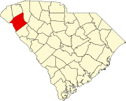 | |
| Towns | ||
| CDPs | ||
| Other communities | ||
| Footnotes | ‡This populated place also has portions in an adjacent county or counties | |
| ||
Другой контент может иметь иную лицензию. Перед использованием материалов сайта WikiSort.org внимательно изучите правила лицензирования конкретных элементов наполнения сайта.
WikiSort.org - проект по пересортировке и дополнению контента Википедии