world.wikisort.org - USA
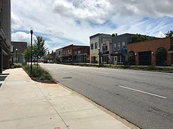
West Columbia, formerly Brookland, is a city and commuter town in the suburban eastern sections of Lexington County, South Carolina, United States. According to the 2010 census, the population was 14,988, and the 2019 population estimate was 17,998.[6] West Columbia is bordered to the east by Columbia, the state capital, across the Congaree River. It is near Columbia's city center or downtown district as well as the South Carolina State House and the Congaree Vista, known locally as "the Vista." The city is bordered to the south by its sister suburb, Cayce. A small portion of the city borders the town of Lexington to the east.[7][8] West Columbia is part of the greater Columbia, SC metropolitan statistical area.
West Columbia, South Carolina | |
|---|---|
City | |
 | |
| Motto(s): "Bridging Past, Present, And Future"[1] | |
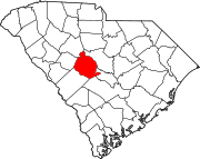
 Location in Lexington County, South Carolina | |
| Coordinates: 33°59′27.8″N 81°4′23.4″W | |
| Country | United States |
| State | South Carolina |
| County | Lexington |
| Government | |
| • Type | City Council, City Administrator |
| • Mayor | Tem Miles[2] |
| Area | |
| • Total | 9.47 sq mi (24.53 km2) |
| • Land | 9.30 sq mi (24.08 km2) |
| • Water | 0.17 sq mi (0.45 km2) |
| Elevation | 282 ft (86 m) |
| Population (2020)[5] | |
| • Total | 17,416 |
| • Density | 1,873.49/sq mi (723.38/km2) |
| Time zone | UTC−5 (EST) |
| • Summer (DST) | UTC−4 (EDT) |
| Area code(s) | 803, 839 |
| FIPS code | 45-75850 |
| GNIS feature ID | 1251380[4] |
| Website | www |
History


West Columbia was incorporated in 1894 as "Brookland", but the U.S. Postal Service called the town "New Brookland" since there was another town called Brookland. In 1936, the name was changed to "West Columbia" to emphasize its proximity to Columbia, the capital.[1] Numerous businesses, churches and a high school retain the Brookland and New Brookland names.
The Gervais Street Bridge, Mount Hebron Temperance Hall, New Brookland Historic District, and Saluda Factory Historic District are listed on the National Register of Historic Places.[9]
The 2008 South Carolina Learjet 60 crash occurred just before midnight on September 19, 2008, when a Learjet 60 (registration N999LJ[10]) crashed while taking off from Columbia Metropolitan Airport.[11][12] The weather at the time was cool, dry, and clear. The plane hit runway lights and crashed through the boundary fence, crossing South Carolina Highway 302 (SC 302/Edmund Highway/Airport Boulevard), and coming to rest on an embankment by the side of the highway. No one on the ground was hurt, but four of the six people on the plane (including both pilots) died in the crash, while the other two, Travis Barker (the drummer of Blink-182) and Adam Goldstein (DJ AM of Crazy Town), suffered severe burns. The plane was a charter flight taken by Barker, Goldstein and their entourage following a performance by their musical group TRV$DJAM at a free concert in Five Points earlier that night to Van Nuys, California.
Geography
West Columbia lies to the south and west of the Saluda and Congaree rivers.
According to the United States Census Bureau, the city has a total area of 6.3 square miles (16.3 km2), of which 6.1 square miles (15.7 km2) is land and 0.2 square mile (0.5 km2) (3.18%) is water.
Demographics
| Historical population | |||
|---|---|---|---|
| Census | Pop. | %± | |
| 1900 | 1,089 | — | |
| 1910 | 900 | −17.4% | |
| 1920 | 1,793 | 99.2% | |
| 1930 | 1,722 | −4.0% | |
| 1940 | 1,744 | 1.3% | |
| 1950 | 1,543 | −11.5% | |
| 1960 | 6,410 | 315.4% | |
| 1970 | 7,838 | 22.3% | |
| 1980 | 10,409 | 32.8% | |
| 1990 | 10,588 | 1.7% | |
| 2000 | 13,064 | 23.4% | |
| 2010 | 14,988 | 14.7% | |
| 2020 | 17,416 | 16.2% | |
| U.S. Decennial Census[13][5] | |||
2020 census
| Race | Num. | Perc. |
|---|---|---|
| White (non-Hispanic) | 11,022 | 63.29% |
| Black or African American (non-Hispanic) | 2,959 | 16.99% |
| Native American | 58 | 0.33% |
| Asian | 490 | 2.81% |
| Pacific Islander | 5 | 0.03% |
| Other/Mixed | 732 | 4.2% |
| Hispanic or Latino | 2,150 | 12.34% |
As of the 2020 United States census, there were 17,416 people, 8,315 households, and 3,764 families residing in the city.
2000 census
As of the census of 2000, there were 13,064 people, 5,968 households, and 3,300 families residing in the city. The population density was 2,150.6 people per square mile (831.0/km2). There were 6,436 housing units at an average density of 1,059.5 per square mile (409.4/km2). The racial makeup of the city was 74.54% White, 19.81% African American, 0.28% Native American, 1.71% Asian, 0.02% Pacific Islander, 2.04% from other races, and 1.61% from two or more races. Hispanic or Latino of any race were 4.66% of the population.
There were 5,968 households, out of which 22.0% had children under the age of 18 living with them, 37.5% were married couples living together, 14.3% had a female householder with no husband present, and 44.7% were non-families. 36.1% of all households were made up of individuals, and 13.0% had someone living alone who was 65 years of age or older. The average household size was 2.13 and the average family size was 2.76.
In the city, the population was spread out, with 18.8% under the age of 18, 10.1% from 18 to 24, 30.0% from 25 to 44, 22.1% from 45 to 64, and 19.0% who were 65 years of age or older. The median age was 39 years. For every 100 females, there were 88.5 males. For every 100 females age 18 and over, there were 86.1 males.
The median income for a household in the city was $30,999, and the median income for a family was $40,253. Males had a median income of $30,033 versus $24,637 for females. The per capita income for the city was $18,135. About 12.8% of families and 16.8% of the population were below the poverty line, including 24.5% of those under age 18 and 11.4% of those age 65 or over. West Columbia is the home of Glenforest School.
Education
West Columbia has a public library, a branch of the Lexington County Public Library.[15]
Notable people
- Duce Staley, former professional football player and football coach
See also
- Columbia Metropolitan Airport
- Lexington Medical Center
- Riverbanks Zoo
References
- "City of West Columbia South Carolina". City of West Columbia South Carolina. Retrieved October 3, 2012.
- "City Council". City of West Columbia. Retrieved 1 May 2015.
- "ArcGIS REST Services Directory". United States Census Bureau. Retrieved October 15, 2022.
- U.S. Geological Survey Geographic Names Information System: West Columbia, South Carolina
- "Census Population API". United States Census Bureau. Retrieved Oct 15, 2022.
- "West Columbia Census Quick Facts". U.S. Census Bureau. 2019. Retrieved 29 June 2020.
- "West Columbia Zoning". Lexington County GIS. Retrieved 29 June 2020.
- "Lexington, SC Annexation". Lexington County GIS. Retrieved 29 June 2020.
- "National Register Information System". National Register of Historic Places. National Park Service. July 9, 2010.
- "FAA Registry (N999LJ)". Federal Aviation Administration.
- 4 killed, 2 hurt as rock star's jet crashes, as well as Today.com News Live, 8:30 AM, September 20, 2008.
- Meg Kinnard "Experts: Pilots of doomed Learjet should've lifted off SC runway instead of trying to stop", NewsDay, (Associated Press) October 22, 2008
- United States Census Bureau. "Census of Population and Housing". Retrieved August 14, 2013.
- "Explore Census Data". data.census.gov. Retrieved 2021-12-13.
- "Locations". Lexington County Public Library. Retrieved 28 September 2022.
External links
На других языках
[de] West Columbia (South Carolina)
West Columbia ist eine Stadt (City) im Lexington County im Bundesstaat South Carolina in den Vereinigten Staaten. Bei der letzten Volkszählung im Jahr 2010 lebten 14.988 Einwohner in der Stadt. West Columbia ist Teil der Metropolregion um Columbia.- [en] West Columbia, South Carolina
Другой контент может иметь иную лицензию. Перед использованием материалов сайта WikiSort.org внимательно изучите правила лицензирования конкретных элементов наполнения сайта.
WikiSort.org - проект по пересортировке и дополнению контента Википедии
