world.wikisort.org - USA
Mauldin is a city in Greenville County, South Carolina, United States. The population was 24,724 at the 2020 census. It is a principal city of the Greenville-Anderson-Mauldin Metropolitan Statistical Area.
Mauldin, South Carolina | |
|---|---|
City | |
| City of Mauldin | |
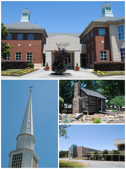 Top, left to right: Mauldin City Hall, Mauldin United Methodist Church, Mauldin Cultural Center, Mauldin High School | |
 Flag Seal | |
| Motto: "Explore Our Thriving Community" | |
 Location of Mauldin, South Carolina | |
| Coordinates: 34°46′51″N 82°18′2″W | |
| Country | United States |
| State | South Carolina |
| County | Greenville |
| Area | |
| • Total | 12.13 sq mi (31.42 km2) |
| • Land | 12.07 sq mi (31.26 km2) |
| • Water | 0.06 sq mi (0.17 km2) |
| Elevation | 942 ft (287 m) |
| Population (2020)[3] | |
| • Total | 24,724 |
| • Density | 2,048.72/sq mi (791.00/km2) |
| Time zone | UTC-5 (Eastern (EST)) |
| • Summer (DST) | UTC-4 (EDT) |
| ZIP code | 29662 |
| Area code | 864 |
| FIPS code | 45-45115[4] |
| GNIS feature ID | 1246563[2] |
| Website | www |
Geography

Mauldin is located south of the center of Greenville County, between the city of Greenville to the northwest and Simpsonville to the southeast. According to the United States Census Bureau, the city has a total area of 10.0 square miles (25.9 km2), of which 0.04 square miles (0.1 km2), or 0.46%, are water.[5]
U.S. Route 276 (Main Street) passes through the center of Mauldin, leading northwest 8 miles (13 km) to the center of Greenville and southeast 5 miles (8 km) to Simpsonville. Interstate 385 runs through the eastern side of Mauldin, leading north to Interstate 85 on the east side of Greenville. I-385 connects with Interstate 185 on the southern edge of Mauldin, and I-185 continues west and northwest 13 miles (21 km) to join I-85 on the southwest side of Greenville. From its interchange with I-185, I-385 leads southeast 30 miles (48 km) to Interstate 26 near Clinton.
History
Benjamin Griffith was awarded the first land grant in what is now called Mauldin in 1784. The name of Mauldin was given to the town almost accidentally in 1820 thanks to South Carolina's lieutenant governor, W. L. Mauldin. The train station was called "Mauldin" because the lieutenant governor had assisted in getting the Greenville and Laurens Railroad to come through the village. Over time, the entire area took the name of Mauldin.
During the Civil War, many of Mauldin's citizens left to fight, and the city virtually dried up. It never completely recovered until after World War II when the community was incorporated as a town (1960).
Demographics
| Historical population | |||
|---|---|---|---|
| Census | Pop. | %± | |
| 1960 | 1,462 | — | |
| 1970 | 3,797 | 159.7% | |
| 1980 | 8,143 | 114.5% | |
| 1990 | 11,587 | 42.3% | |
| 2000 | 15,224 | 31.4% | |
| 2010 | 22,889 | 50.3% | |
| 2020 | 24,724 | 8.0% | |
| 2021 (est.) | 25,654 | [6] | 3.8% |
| U.S. Decennial Census[7] 2020[8][3] | |||
2020 census
| Race | Num. | Perc. |
|---|---|---|
| White (non-Hispanic) | 14,551 | 58.85% |
| Black or African American (non-Hispanic) | 5,821 | 23.54% |
| Native American | 36 | 0.15% |
| Asian | 802 | 3.24% |
| Pacific Islander | 42 | 0.17% |
| Other/Mixed | 1,115 | 4.51% |
| Hispanic or Latino | 2,357 | 9.53% |
As of the 2020 United States census, there were 24,724 people, 9,968 households, and 6,339 families residing in the city.
2000 census
As of the census[4] of 2000, there were 15,224 people, 6,131 households, and 4,242 families residing in the city. The population density was 1,767.1 people per square mile (681.9/km2). There were 6,500 housing units at an average density of 754.5 per square mile (291.1/km2). The racial makeup of the city was 74.25% White, 20.82% African American, 0.30% Native American, 2.24% Asian, 0.11% Pacific Islander, 0.98% from other races, and 1.31% from two or more races. Hispanic or Latino of any race were 2.73% of the population.
There were 6,131 households, out of which 33.9% had children under the age of 18 living with them, 55.8% were married couples living together, 10.4% had a female householder with no husband present and 30.8% were non-families. 26.0% of all households were made up of individuals, and 6.2% had someone living alone who was 65 years of age or older. The average household size was 2.46 and the average family size was 2.97.
In the city, the population was spread out, with 25.0% under the age of 18, 8.1% from 18 to 24, 33.5% from 25 to 44, 24.1% from 45 to 64, and 9.3% who were 65 years of age or older. The median age was 35 years. For every 100 females, there were 93.2 males. For every 100 females age 18 and over, there were 91.0 males.
The median income for a household in the city was $51,657, and the median income for a family was $61,817. Males had a median income of $41,047 versus $29,985 for females. The per capita income for the city was $24,750. About 3.2% of families and 4.4% of the population were below the poverty line, including 6.7% of those under age 18 and 9.2% of those age 65 or over.
Economy
The supermarket chain BI-LO was founded in Mauldin and had its headquarters there until 2011.[10][11]
Education
Public education in Mauldin is administered by Greenville County School District. The district operates Mauldin High School.
LEAD Academy is a free, public charter school in Mauldin serving kindergarten through eighth grade students.
Mauldin has a public library, a branch of the Greenville County Library System.[12]
Notable people
- Kevin Garnett, Olympian, professional basketball player
- Orlando Jones, actor
- Al Yeargin, professional baseball player
References
- "ArcGIS REST Services Directory". United States Census Bureau. Retrieved October 15, 2022.
- U.S. Geological Survey Geographic Names Information System: Mauldin, South Carolina
- "Census Population API". United States Census Bureau. Retrieved Oct 15, 2022.
- "U.S. Census website". United States Census Bureau. Retrieved 2008-01-31.
- "Geographic Identifiers: 2010 Demographic Profile Data (G001): Mauldin city, South Carolina". American Factfinder. U.S. Census Bureau. Retrieved February 9, 2017.[dead link]
- "U.S. Census Bureau QuickFacts: Mauldin city, South Carolina". www.census.gov. Retrieved September 14, 2022.
- "Census of Population and Housing". Census.gov. Retrieved June 4, 2015.
- "U.S. Census Bureau QuickFacts: Mauldin city, South Carolina". www.census.gov. Retrieved September 14, 2022.
- "Explore Census Data". data.census.gov. Retrieved 2021-12-14.
- "Contact Us." BI-LO. January 5, 2006. Retrieved on October 5, 2012. "Shipping Address: BI-LO, LLC 208 BI-LO Blvd. Greenville, SC 29607"
- "Zoning and Parcels Map." (Archive) City of Mauldin. Retrieved on October 5, 2012.
- "Locations & Hours". Greenville County Library System. Retrieved 8 June 2019.
External links
Municipalities and communities of Greenville County, South Carolina, United States | ||
|---|---|---|
County seat: Greenville | ||
| Cities | 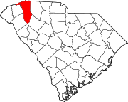 | |
| CDPs | ||
| Other communities |
| |
| Footnotes | ‡This populated place also has portions in an adjacent county or counties | |
| ||
Authority control | |
|---|---|
| General | |
| National libraries | |
| Other |
|
На других языках
[de] Mauldin (South Carolina)
Mauldin ist eine US-amerikanische Stadt im Greenville County im nordwestlichen Teil des Bundesstaats South Carolina. Sie hat etwa 15.000 Einwohner (Stand: Volkszählung 2000) auf einer Fläche von 22,3 km² und liegt 290 m ü. NN auf dem Piedmont Plateau.- [en] Mauldin, South Carolina
Другой контент может иметь иную лицензию. Перед использованием материалов сайта WikiSort.org внимательно изучите правила лицензирования конкретных элементов наполнения сайта.
WikiSort.org - проект по пересортировке и дополнению контента Википедии