world.wikisort.org - Turkey
Uludere (Kurdish: Qileban)[3] is a district in Şırnak Province, Turkey. Its mayor is Sait Ürek from the party AKP.[4]
Uludere | |
|---|---|
 | |
 Uludere | |
| Coordinates: 37°25′0″N 42°54′0″E | |
| Country | |
| Province | Şırnak |
| Government | |
| • Mayor | Sait Ürek (AKP) |
| • Kaymakam | Naif Yusuf |
| Area | |
| • District | 731.30 km2 (282.36 sq mi) |
| Population (2012)[2] | |
| • Urban | 10,013 |
| • District | 38,201 |
| • District density | 52/km2 (140/sq mi) |
| Post code | 736xx |
| Website | www.uludere.bel.tr |
Composition
Around 90% of the district is populated by Kurds from the Goyan tribe.[5]
| Settlement[5] | Ethnicity (tribe) |
|---|---|
| Uludere (Qileban) | Kurdish (Goyan)[6] |
| Andaç (Elemûna) | Kurdish (Qeşuran)[7] |
| Bağlı (Kulgi) | Kurdish (Goyan)[8] |
| Bağlıca (Kudin) | Kurdish (Goyan)[8] |
| Ballı (Şiwêt) | Kurdish (Goyan)[8] |
| Dağdibi (Hedrîn) | Kurdish (Goyan)[9] |
| Gülyazı (Bujeh) | Kurdish (Goyan)[8] |
| Hilal (Şêxan) | Kurdish (Goyan)[8] |
| Inceler (Ziravik) | Kurdish (Goyan)[8] |
| Işıkveren (Bîleh) | Kurdish (Goyan)[8] |
| Ortabağ (Kirur) | Kurdish (Goyan)[8] |
| Ortaköy (Oriş) | Kurdish (Qeşuran)[7] |
| Ortasu (Robozik) | Kurdish (Goyan)[9] |
| Şenoba (Sêgirik) | Kurdish (Goyan)[10] |
| Taşdelen (Nerweh) | Kurdish (Goyan)[8] |
| Uzungeçit (Dêra Hînê) | Kurdish (Goyan)[8] |
| Yemişli (Mergeh) | Kurdish (Goyan)[8] |
Geography
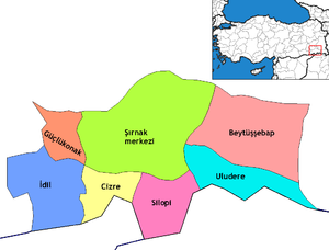
Uludere's total land area is 825 km². Its neighbors are: the district of Çukurca in the province of Hakkâri to the east; the districts of Şırnak and Silopi to the west; the district of Beytüşşebap to the north; and the country of Iraq to the south.
The topography of Uludere consists mostly of rugged mountainous terrain. The Haftanîn and Kêla Meme (Kel Mehmet) mountains are the highest mountains in Uludere. In addition, Suwar, Serhe, Haftanîn, Meydan, Elcan and Şirîş are important plateaus. The altitude varies between 800 meters and 3200 meters throughout the district. The lowest altitude is in the Şenoba town and the highest altitude is in the Kel Mehmet (Kêla Meme) mountain.[11]
See also
- Uludere airstrike
References
- "Area of regions (including lakes), km²". Regional Statistics Database. Turkish Statistical Institute. 2002. Retrieved 2013-03-05.
- "Population of province/district centers and towns/villages by districts - 2012". Address Based Population Registration System (ABPRS) Database. Turkish Statistical Institute. Retrieved 2013-02-27.
- Adem Avcıkıran (2009). Kürtçe Anamnez Anamneza bi Kurmancî (PDF) (in Turkish and Kurdish). p. 57. Retrieved 17 December 2019.
- "Şırnak Uludere Seçim Sonuçları - 31 Mart 2019 Yerel Seçimleri". www.sabah.com.tr. Retrieved 2019-09-11.
- Baz, Ibrahim (2016). Şırnak aşiretleri ve kültürü (in Turkish). p. 28. ISBN 9786058849631.
- Peter Alfred, Andrews; Benninghaus, Rüdiger, eds. (1989). Ethnic Groups in the Republic of Turkey. p. 218.
- Baz, Ibrahim (2016). Şırnak aşiretleri ve kültürü (in Turkish). p. 104. ISBN 9786058849631.
- Baz, Ibrahim (2016). Şırnak aşiretleri ve kültürü (in Turkish). p. 125. ISBN 9786058849631.
- "Şırnak İli Uludere İlçesi Köyleri Alan Araştırması (yönetici özeti)" (PDF) (in Turkish). p. 17. Retrieved 17 September 2022.
- Baz, Ibrahim (2016). Şırnak aşiretleri ve kültürü (in Turkish). p. 123. ISBN 9786058849631.
- "Uludere'de Coğrafi Yapı" ["Geography of Uludere"], an Uludere governmental webpage
Uludere in Şırnak Province of Turkey | |||||||||||||||||||||||||||
|---|---|---|---|---|---|---|---|---|---|---|---|---|---|---|---|---|---|---|---|---|---|---|---|---|---|---|---|
| Districts |
|   | |||||||||||||||||||||||||
||
Metropolitan municipalities are bolded. | |||||||||||||||||||||||||||
На других языках
[de] Uludere
Uludere (kurdisch: Qilaban oder Keleban) ist eine türkische Stadt und ein gleichnamiger Landkreis in der Provinz Şırnak in Südostanatolien.- [en] Uludere
[ru] Улудере
Улудере (тур. Uludere) — город и район в провинции Ширнак (Турция).Другой контент может иметь иную лицензию. Перед использованием материалов сайта WikiSort.org внимательно изучите правила лицензирования конкретных элементов наполнения сайта.
WikiSort.org - проект по пересортировке и дополнению контента Википедии