world.wikisort.org - Turkey
Kırşehir Province (Turkish: Kırşehir ili) is located in central Turkey, forming part of the central Anatolian region. It stands on the North Anatolian Fault, and is currently in an earthquake warning zone. The average elevation is approximately 985 meters above sea level. The provincial capital is Kırşehir.
Kırşehir Province
Kırşehir ili | |
|---|---|
Province of Turkey | |
 | |
 Location of Kırşehir Province in Turkey | |
| Country | Turkey |
| Region | Central Anatolia |
| Subregion | Kırıkkale |
| Largest City | Kırşehir |
| Government | |
| • Electoral district | Kırşehir |
| Area | |
| • Total | 6,570 km2 (2,540 sq mi) |
| Population (2018)[1] | |
| • Total | 241,868 |
| • Density | 37/km2 (95/sq mi) |
| Area code | 0386 |
| Vehicle registration | 40 |
It became a province in 1924. On 30 May 1954, it was accepted as a district of Nevşehir. Later, the towns of Kırşehir were divided between Ankara, Yozgat and Nevşehir. In 1957, Kırşehir became a province again.[citation needed]
69th largest city by population in Turkey, Kırşehir making up %0,84 of Turkey's land area.[2] (53rd largest city by land area in the country)


Districts
Kırşehir province is divided into 7 districts (capital district in bold):
See also
- List of populated places in Kırşehir Province
References
- "Population of provinces by years - 2000-2018". Turkish Statistical Institute. Retrieved 9 March 2019.
- GLHN (2022-07-23). "Kırşehir". Ansiklopedika Viki (in Turkish). Retrieved 2022-09-18.
External links
![]() Media related to Kırşehir Province at Wikimedia Commons
Media related to Kırşehir Province at Wikimedia Commons
- (in Turkish) Kırşehir governor's official website
- (in Turkish) Kırşehir municipality's official website
- (in English) Kırşehir weather forecast information
- Kırşehir tourist information
- Kırşehir information web pages
- Kırşehir Haber
Kırşehir Province of Turkey | |||||||||||||||||||||||||||
|---|---|---|---|---|---|---|---|---|---|---|---|---|---|---|---|---|---|---|---|---|---|---|---|---|---|---|---|
| Districts |  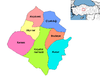 | ||||||||||||||||||||||||||
|
Metropolitan municipalities are bolded. | |||||||||||||||||||||||||||
Authority control | |
|---|---|
| General |
|
| National libraries | |
| Other |
|
This geographical article about a location in Kırşehir Province, Turkey is a stub. You can help Wikipedia by expanding it. |
На других языках
[de] Kırşehir (Provinz)
Kırşehir ist eine Provinz der Türkei. Ihre Hauptstadt ist das gleichnamige Kırşehir.- [en] Kırşehir Province
[ru] Кыршехир (ил)
Кыршехир (тур. Kirşehir) — ил в центральной части Турции.Другой контент может иметь иную лицензию. Перед использованием материалов сайта WikiSort.org внимательно изучите правила лицензирования конкретных элементов наполнения сайта.
WikiSort.org - проект по пересортировке и дополнению контента Википедии