world.wikisort.org - Turkey
Nevşehir (from the Persian compound نو شهر Now-shahr meaning "new city"), formerly Neapolis (Ancient Greek: Νεάπολις) and Muşkara, is a largely modern city and the capital district of Nevşehir Province in the Central Anatolia Region of Turkey. According to the 2020 census, the population of the city is 82,110. [3] It is 290 km (180 mi) from the capital Ankara and lies within the historical region of Cappadocia.
Nevşehir | |
|---|---|
Municipality | |
 Panoramic view from Nevşehir Castle | |
 Nevşehir | |
| Coordinates: 38°37′35″N 34°42′50″E | |
| Country | Turkey |
| Province | Nevşehir |
| Government | |
| • Mayor | Rasim Arı (AKP) |
| Area | |
| • District | 534.55 km2 (206.39 sq mi) |
| Elevation | 1,224 m (4,016 ft) |
| Population (2012)[2] | |
| • Urban | 92,068 |
| • District | 123,976 |
| • District density | 230/km2 (600/sq mi) |
| Website | www.nevsehir.bel.tr |
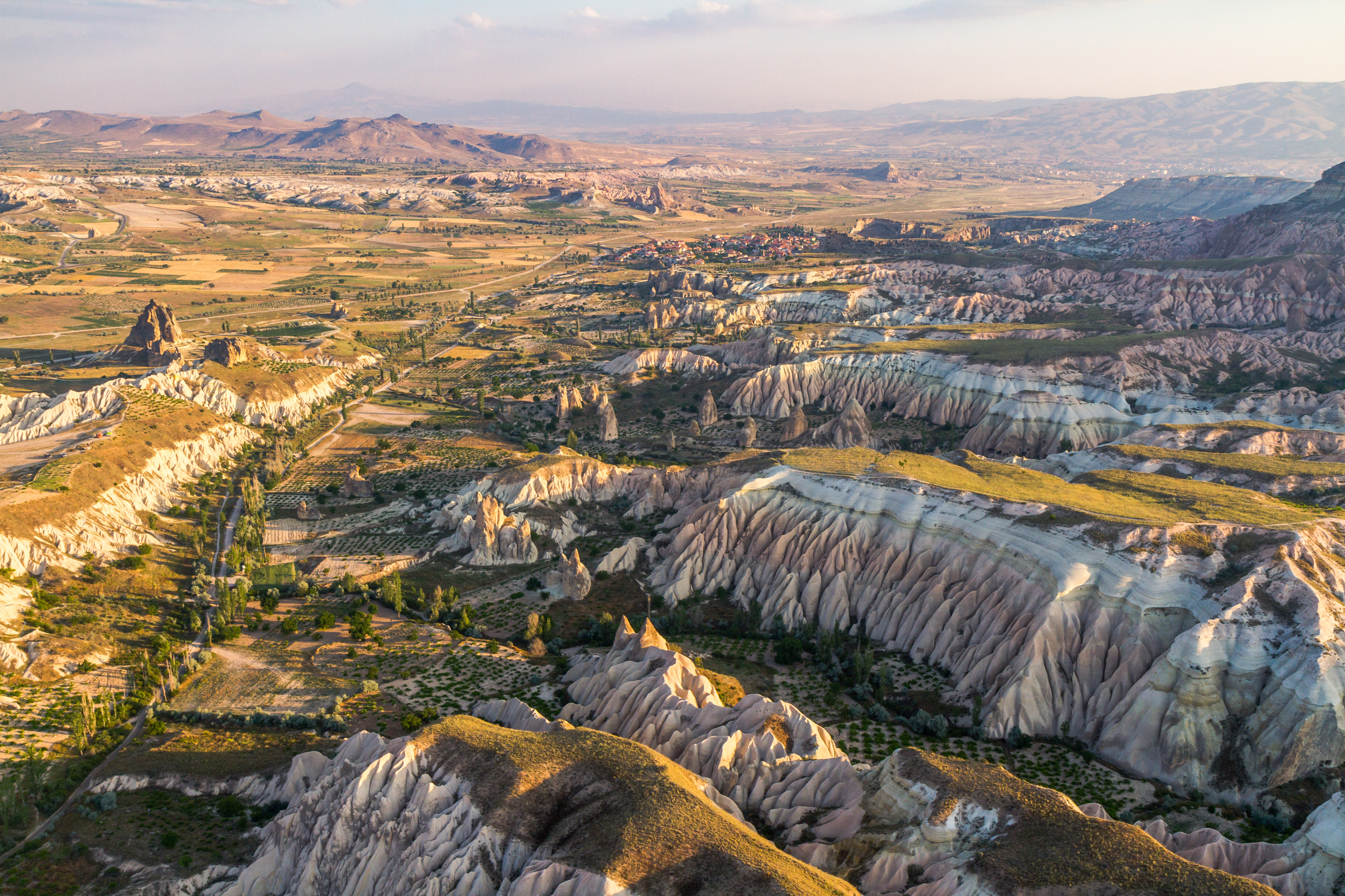
The town lies at an elevation of 1,224 m (4,016 ft) and has a continental climate, with heavy snow in winter and great heat in summer. Although Nevşehir is close to the underground cities, fairy chimneys, monasteries, caravanserais and rock-hewn churches of Cappadocia, and has a few hotels, the modern town is not itself a tourist centre. In 2015 a huge underground city was discovered underneath its centre following demolition works intended to clear the central hillside of ramshackle modern housing.[4]
Founded in 2007, Nevşehir University was renamed Nevşehir Hacı Bektaş Veli University in 2013.[5]
Nevşehir Kapadokya Airport (NAV) is 30 kilometres northwest of the town.[6]The inter-city bus station is about 6 km southwest of the city centre. Two planned high-speed rail services should eventually link Nevşehir to Antalya, Konya, Kayseri and Ankara.[7]
History
Prehistory and ancient history
The Hittites first founded a settlement on the slopes of Mount Kahveci in the valley of Kızılırmak (the ancient Halys). This town, along with the region, came under the rule of the Assyrian Empire around the 8th century BC, and was subsequently ruled by the Medes and then by the Persians during the reign of emperor Cyrus the Great in 546 BC. In 333 BC, Alexander the Great defeated the Persians and after his death, the surrounding area came under the rule of the dynasty of Ariarathes with Mazaka (present-day Kayseri) as its capital. The Cappadocian kingdom became a province- of the Roman empire in the reign of Emperor Tiberius.
Medieval history
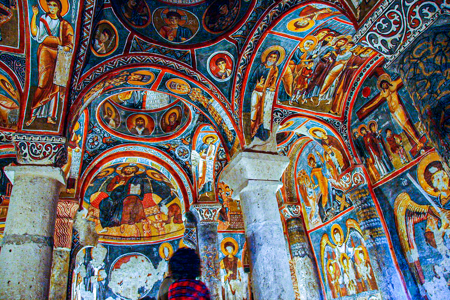
The so-called underground cities found around Nevşehir may originally have been built to escape persecution by the pagan Roman authorities although others believe they date back to Hittite times.[8] Many of the churches, hewn in the rocks, date from these early years of Christianity. Even when Theodosius I made Christianity the official religion of the empire, the caves offered protection for the local people during raids by the Sassanid Persians circa AD 604 and by the Islamic Caliphate from AD 647 onwards. When Iconoclasm became state policy in the Byzantine empire, again the caves around Nevşehir became shelters for those escaping persecution.
The castle on the hill in the middle of Nevşehir dates from the Byzantine period, when the region was on the frontline in the (holy) wars against the Islamic Caliphate.[9]
At the Battle of Manzikert (present-day Malazgirt) in AD 1071, the Byzantine emperor Romanos IV was defeated by the Seljuk Sultan Alp Arslan which led to the occupation of Anatolia by the Seljuks by 1074. Along with the rest of the region, Nevşehir became part of the Seljuk Sultanate of Rum, then fell under the rule of the Karamanid dynasty in 1328 and finally under Ottoman rule around 1487 AD when it was renamed Muşkara. It remained relatively insignificant until the early 18th century.
Modern history

The present-day city owes its foundation in the so-called Tulip Age to the grand vizier and son-in-law of the Sultan Ahmed III, Nevşehirli Damad İbrahim Pasha who was born in Muşkara and later took a great interest in its expansion. The small village with only 18 houses, formerly under the administration of the kaza of Ürgüp, was rapidly transformed with the building of mosques (the Kurṣunlu Mosque), fountains, schools, soup kitchens, inns and bath houses, and its name was changed from Muşkara to "Nevşehir" (meaning New City in Persian and Ottoman Turkish). In 1730 the grand vizier was assassinated by rebels in İstanbul but by then Nevşehir was firmly established as a town.[10] The present-day city owes its foundation in the so-called Tulip Age to the grand vizier and son-in-law of the Sultan Ahmed III, Nevşehirli Damad İbrahim Pasha who was born in Muşkara and later took a great interest in its expansion. The small village with only 18 houses, formerly under the administration of the kaza of Ürgüp, was rapidly transformed with the building of mosques (the [[:c:|Kurṣunlu Mosque), fountains, schools, soup kitchens, inns and bath houses, and its name was changed from Muşkara to "Nevşehir" (meaning New City in Persian and Ottoman Turkish). In 1730 the grand vizier was assassinated by rebels in İstanbul but by then Nevşehir was firmly established as a town.[11]
According to the Ottoman General Census of 1881/82-1893, the kaza of Nevşehir had a total population of 39,822, consisting of 30,370 Muslims, 8,918 Greeks, 477 Armenians, 36 Catholics and 21 Protestants.[12]
Under the terms of the Convention Concerning the Exchange of Greek and Turkish Populations in 1923, the Turkish speaking Greek Orthodox community (Karamanlis) of Nevşehir was exchanged for Muslims from Osheni, Shak and Revani villages of Kesriye (today's Οινόη, Κομνηνάδες and Διποταμία villages of Kastoria, Western Macedonia, Greece).


Gallery
 Nevşehir Castle from exterior
 Interior of Nevsehir Castle
 Nevşehir Castle above the underground city discovered in 2015
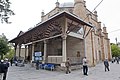 18th-century Damat Ibrahim Pasha mosque complex
 Interior of Damat Ibrahim Pasha Mosque
 Nevşehir's Damat Ibrahim Pasha complex includes a hamam
 Medrese of Damat Ibrahim Pasha mosque complex
 Disused Church of the Virgin Mary in Nevşehir
 Greek (Rum) bathhouse in Nevşehir
 Nevşehir Museum: Middle Bronze Age pot, 2000-1200 BC
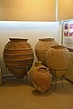 Nevşehir Museum: Late Byzantine earthenware vessels
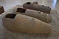 Nevşehir Museum: terracotta sarcophagi, 3rd-4th centuries AD
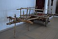 Nevşehir Museum: ox-drawn cart
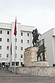 Nevşehir municipality offices and statue of Atatürk


Climate
Nevşehir has a continental climate (Köppen climate classification: Dsa, Trewartha climate classification: Dc), with cold, snowy winters and warm, dry summers. Precipitation occurs throughout the year, with a slight peak in spring.
| Climate data for Nevşehir (1991–2020, extremes 1959–2020) | |||||||||||||
|---|---|---|---|---|---|---|---|---|---|---|---|---|---|
| Month | Jan | Feb | Mar | Apr | May | Jun | Jul | Aug | Sep | Oct | Nov | Dec | Year |
| Record high °C (°F) | 18.6 (65.5) |
19.6 (67.3) |
28.0 (82.4) |
31.6 (88.9) |
32.6 (90.7) |
35.0 (95.0) |
39.5 (103.1) |
38.2 (100.8) |
37.4 (99.3) |
32.0 (89.6) |
27.6 (81.7) |
23.0 (73.4) |
39.5 (103.1) |
| Average high °C (°F) | 4.1 (39.4) |
6.0 (42.8) |
10.9 (51.6) |
16.3 (61.3) |
21.2 (70.2) |
25.6 (78.1) |
29.3 (84.7) |
29.4 (84.9) |
25.3 (77.5) |
19.1 (66.4) |
11.6 (52.9) |
6.2 (43.2) |
17.1 (62.8) |
| Daily mean °C (°F) | 0.0 (32.0) |
1.3 (34.3) |
5.5 (41.9) |
10.4 (50.7) |
15.0 (59.0) |
18.9 (66.0) |
22.2 (72.0) |
22.1 (71.8) |
18.1 (64.6) |
12.8 (55.0) |
6.3 (43.3) |
2.0 (35.6) |
11.2 (52.2) |
| Average low °C (°F) | −3.5 (25.7) |
−2.6 (27.3) |
1.0 (33.8) |
5.2 (41.4) |
9.3 (48.7) |
12.3 (54.1) |
14.6 (58.3) |
14.5 (58.1) |
11.3 (52.3) |
7.4 (45.3) |
2.1 (35.8) |
−1.4 (29.5) |
5.9 (42.6) |
| Record low °C (°F) | −21.2 (−6.2) |
−23.6 (−10.5) |
−18.0 (−0.4) |
−12.5 (9.5) |
−2.3 (27.9) |
1.3 (34.3) |
3.8 (38.8) |
3.1 (37.6) |
−1.2 (29.8) |
−7.6 (18.3) |
−14.0 (6.8) |
−19.5 (−3.1) |
−23.6 (−10.5) |
| Average precipitation mm (inches) | 43.7 (1.72) |
41.8 (1.65) |
47.5 (1.87) |
45.7 (1.80) |
57.4 (2.26) |
37.5 (1.48) |
9.9 (0.39) |
9.6 (0.38) |
13.7 (0.54) |
29.4 (1.16) |
33.4 (1.31) |
48.4 (1.91) |
418.0 (16.46) |
| Average precipitation days | 8.80 | 7.83 | 10.27 | 11.33 | 13.40 | 8.40 | 2.40 | 2.37 | 3.83 | 6.93 | 7.10 | 9.30 | 92.0 |
| Mean monthly sunshine hours | 96.1 | 118.7 | 164.3 | 204.0 | 257.3 | 309.0 | 365.8 | 347.2 | 276.0 | 195.3 | 138.0 | 86.8 | 2,558.5 |
| Mean daily sunshine hours | 3.1 | 4.2 | 5.3 | 6.8 | 8.3 | 10.3 | 11.8 | 11.2 | 9.2 | 6.3 | 4.6 | 2.8 | 7.0 |
| Source: Turkish State Meteorological Service[13] | |||||||||||||
Notes
- "Area of regions (including lakes), km²". Regional Statistics Database. Turkish Statistical Institute. 2002. Retrieved 2013-03-05.
- "Population of province/district centers and towns/villages by districts - 2012". Address Based Population Registration System (ABPRS) Database. Turkish Statistical Institute. Retrieved 2013-02-27.
- "Population of Nevsehir 2022 | Nevsehir population - statistics". Population HUB. Retrieved 2022-08-09.
- "Massive Underground City Found in Cappadocia Region of Turkey". Adventure. 2015-03-26. Retrieved 2022-04-11.
- "Tarihçe | Nevşehir Hacı Bektaş Veli Üniversitesi".
- "KAPADOKYA HAVALİMANI". www.dhmi.gov.tr. Retrieved 2022-08-09.
- "Not 1, but 2 high-speed train lines will pass through Nevşehir".
- "Derinkuyu: Mysterious underground city in Turkey found in man's basement". Big Think. Retrieved 2022-08-09.
- fibhaber.com. "Nevşehir Kalesi tarihe ışık tutuyor". fibhaber.com (in Turkish). Retrieved 2022-08-09.
- "Nevşehirli Damat İbrahim Paşa". www.biyografya.com. Retrieved 2022-08-09.
- "Nevşehirli Damat İbrahim Paşa". www.biyografya.com. Retrieved 2022-08-09.
- Kemal Karpat (1985), Ottoman Population, 1830-1914, Demographic and Social Characteristics, The University of Wisconsin Press, p. 142-143
- "Resmi İstatistikler: İllerimize Ait Mevism Normalleri (1991–2020)" (in Turkish). Turkish State Meteorological Service. Retrieved 6 July 2021.
References
This article includes a list of general references, but it lacks sufficient corresponding inline citations. (April 2009) |
- Falling Rain Genomics, Inc. "Geographical information on Nevşehir, Turkey". Retrieved 2008-04-12.
- Kenthaber.com. "General information on Nevşehir, Turkey" (in Turkish). Archived from the original on 2011-09-28. Retrieved 2008-04-12.
External links
- Nevşehir Travel governor's official website (in Turkish)
- Nevşehir governor's official website (in Turkish)
- Map of Nevşehir district[permanent dead link]
- Nevşehir municipality's official website (in Turkish)
- Nevşehir (in Turkish)
- Some 200 pictures of the town and its sights
- Administrative map of Nevşehir district Archived 2009-03-05 at the Wayback Machine (in Turkish)
Nevşehir in Nevşehir Province of Turkey | |||||||||||||||||||||||||||
|---|---|---|---|---|---|---|---|---|---|---|---|---|---|---|---|---|---|---|---|---|---|---|---|---|---|---|---|
| Districts |   | ||||||||||||||||||||||||||
|
Metropolitan municipalities are bolded. | |||||||||||||||||||||||||||
Authority control | |
|---|---|
| General | |
| National libraries | |
На других языках
[de] Nevşehir
Nevşehir (früher dt. auch Newschehir) ist die Hauptstadt der gleichnamigen türkischen Provinz Nevşehir und zugleich Zentrum (Merkez) des gleichnamigen Landkreises. Nevşehir bedeutet „Neustadt“. Die Stadt liegt etwa 215 km Luftlinie südöstlich der Landeshauptstadt Ankara in der zentralanatolischen Landschaft Kappadokien.- [en] Nevşehir
[ru] Невшехир
Невшехир (тур. Nevşehir) — город и район в Турции, расположен в центральной части Анатолийского плато. Входит в одноимённый ил. Бывшее название — Мушкара, древнее — Нисса[источник не указан 2170 дней]. Греческое название: Неаполь (греч. Νεάπολη)[1]. В 2000 году, согласно проведённой переписи населения, в Невшехире проживало 67 864 человек. Средняя высота над уровнем моря — 1224 метра. Под городом Невшехир найден древний подземный город.Другой контент может иметь иную лицензию. Перед использованием материалов сайта WikiSort.org внимательно изучите правила лицензирования конкретных элементов наполнения сайта.
WikiSort.org - проект по пересортировке и дополнению контента Википедии