world.wikisort.org - Turkey
Kayseri (Turkish pronunciation: [ˈkajseɾi]; Greek: Καισάρεια) is a large industrialised city in Central Anatolia, Turkey. It is the seat of Kayseri Province. The city of Kayseri, if taken as the Kayseri Metropolitan Municipality, is composed of five urban districts: the two core districts of Kocasinan and Melikgazi, and since 2004, also Hacılar, İncesu and Talas.
Kayseri | |
|---|---|
Metropolitan municipality | |
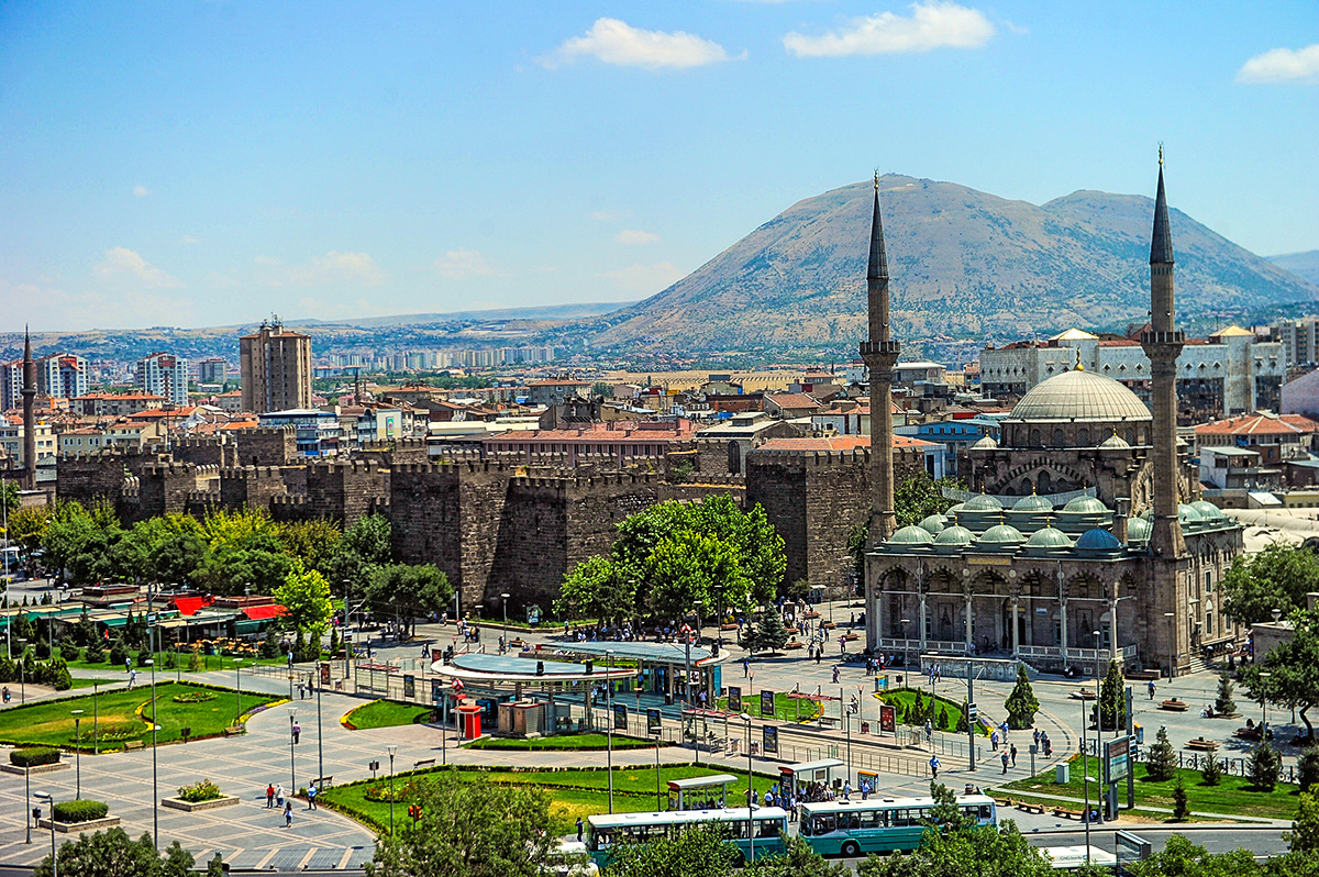
Clockwise from top: Mount Erciyes, Bürüngüz Mosque in Cumhuriyet Square, Sivas Street, Hunat Hatun Complex, Kayseri Castle, Kayseri Tram, Kadir Has Stadium | |
 Kayseri Location of Kayseri, Turkey  Kayseri Kayseri (Asia) | |
| Coordinates: 38°43′21″N 35°29′15″E | |
| Country | Turkey |
| Region | Central Anatolia |
| Province | Kayseri |
| Government | |
| • Mayor | Memduh Büyükkılıç (AKP) |
| Area | |
| • Metropolitan municipality | 17,043 km2 (6,580 sq mi) |
| • Urban | 3,620 km2 (1,400 sq mi) |
| • Metro | 2,810 km2 (1,080 sq mi) |
| Elevation | 1,050 m (3,440 ft) |
| Population (31 December 2021 estimate)[1] | |
| • Metropolitan municipality | 1,434,357 |
| • Density | 84/km2 (220/sq mi) |
| • Urban | 1,204,641 |
| • Urban density | 330/km2 (860/sq mi) |
| • Metro | 1,175,886 |
| • Metro density | 420/km2 (1,100/sq mi) |
| Time zone | UTC+3 (TRT) |
| Postal code | 38x xx |
| Area code | (+90) 352 |
| Licence plate | 38 |
| Website | www |


As of 31 December 2021, the province had a population of 1,434,357 of whom 1,175,886 lived in this city's built-up area identified as four (out of five) urban districts, İncesu not being conurbated (not contiguous, having a largely non-protected buffer zone). Kayseri is at the foot of the inactive volcano Mount Erciyes that reaches an altitude of 3,916 metres (12,848 feet), more than 1,500 metres over the city's mean altitude. The city is often cited in the first ranks among Turkey's Anatolian Tigers.[2]
The city retains a number of historical monuments, including several from the Seljuk period. It is commonly visited en route to the international tourist attractions of once-surrounding Cappadocia, centred to the east as has Seljuk and Ottoman era monuments centrally, Mount Erciyes as a trekking and alpinism centre, Zamantı River as a rafting centre. The closest ruins and excavations, often with museums are those of Kültepe, Ağırnas, Talas and Develi as the locality was prosperous part of the Silk Road. Kayseri is served by Erkilet International Airport and is home to Erciyes University.
Etymology
Kayseri was originally called Mazaka or Mazaca (Armenian: Մաժաք, romanized: Mažak'; according to Armenian tradition, it was founded by and named after Mishak)[3] and was known as such to Strabo, during whose time it was the capital of the Roman province of Cilicia, known also as Eusebia at the Argaeus (Εὐσέβεια ἡ πρὸς τῷ Ἀργαίῳ in Greek), after Ariarathes V Eusebes, King of Cappadocia (163–130 BC).
The name was changed again by Archelaus (d. 17 AD), last King of Cappadocia (36 BC–14 AD) and a Roman vassal, to "Caesarea in Cappadocia" (to distinguish it from other cities with the name Caesarea in the Roman Empire) in honour of Caesar Augustus, upon his death in 14 AD. This name was rendered as Καισάρεια (Kaisáreia) in Koine Greek, which was the dialect of the later Byzantine (Eastern Roman) Empire, and that name remained in use by the natives (nowadays known as Cappadocian Greek, due to their spoken language, but then referred to as Rûm, due to their previous Roman citizenship) until their removal from modern Turkey in 1924. (Note that letter C in classical Latin was pronounced K.) When the first Turks arrived in the region in 1080 AD, they adapted this pronunciation, which eventually became Kayseri in Turkish, remaining as such ever since.[4]
History

Ancient history
Kanesh (at the modern archaeological site of Kültepe), one of the oldest cities in Asia Minor, lies 20 km away.
As Mazaca (Ancient Greek: Μάζακα),[5] the city served as the residence of the kings of Cappadocia. In ancient times, it was on the crossroads of the trade routes from Sinope to the Euphrates and from the Persian Royal Road that extended from Sardis to Susa during the over 200 years of Achaemenid Persian rule. In Roman times, a similar route from Ephesus to the East also crossed the city.
The city stood on a low spur on the north side of Mount Erciyes (Mount Argaeus in ancient times). Only a few traces of the ancient site survive in the old town.
For the Roman and Byzantine eras see Caesarea (Mazaca).
Islamic era


The Arab general (and later the first Umayyad Caliph) Muawiyah invaded Cappadocia and took Caesarea from the Byzantines temporarily in 647.[6] The city was called Kaisariyah (قيصرية) by the Arabs, and later Kayseri (قیصری) by Seljuk Turks,[4] when it was captured by Alp Arslan in 1067. The forces of the latter demolished the city and massacred its population.[7] The shrine of Saint Basil was also sacked after the fall of the city.[8] As a result, the city remained uninhabited for the next half century.[7] Later, during 1074–1178 the area came under the control of the Danishmendids and rebuilt the city in 1134.[9] The Anatolian Seljuk Sultanate controlled the city during the period 1178–1243 and became one of their most prominent centers, until it fell to the Mongols in 1243. Within the walls lies the greater part of Kayseri, rebuilt between the 13th and 16th centuries. Kayseri was successively ruled by Eretnids. The city finally became Ottoman in 1515. It was sanjak center initially in Rum Eyalet (1515–1521), finally in Ankara Vilayet (Founded as Bozok Eyalet) (1839–1923).
Thus, there were three golden-age periods for Kayseri. The first, dating to 2000 BC, was when the city was a trade post between the Assyrians and the Hittites. The second golden age came during the Roman rule (1st to 11th centuries). The third golden age was during the reign of Seljuks (1178–1243), when the city was the second capital of the state. The short-lived Seljuk rule left a large number of historic landmarks; historic buildings such as the Hunat Hatun Complex, Kilij Arslan Mosque, The Grand Mosque and Gevher Nesibe Hospital.
Modern era
The Grand Bazaar dates from the latter part of the 1800s, but the adjacent caravanserai (where merchant traders gathered before forming a caravan) dates from around 1500. The town's older districts (which were filled with ornate mansion-houses mostly dating from the 18th and 19th centuries) were subjected to wholesale demolitions starting in the 1970s.[10]
The building that hosts the Kayseri lyceum was arranged to host the Turkish Grand National Assembly during the Turkish War of Independence when the Greek army had advanced very close to Ankara, the base of the Turkish National Movement. Today the city is famous for its carpet sellers.
Geography
Climate
Kayseri has a cold semi-arid climate in the Köppen climate classification (BSk), or a temperate continental climate in the Trewartha climate classification (Dc). It experiences cold, snowy winters and hot, dry summers with cool nights. Precipitation occurs throughout the year, albeit with a marked decrease in late summer and early fall.
| Climate data for Kayseri (1991–2020, extremes 1931–2020) | |||||||||||||
|---|---|---|---|---|---|---|---|---|---|---|---|---|---|
| Month | Jan | Feb | Mar | Apr | May | Jun | Jul | Aug | Sep | Oct | Nov | Dec | Year |
| Record high °C (°F) | 18.0 (64.4) |
22.6 (72.7) |
28.6 (83.5) |
31.2 (88.2) |
34.2 (93.6) |
37.6 (99.7) |
40.7 (105.3) |
40.6 (105.1) |
38.4 (101.1) |
33.6 (92.5) |
26.0 (78.8) |
21.0 (69.8) |
40.7 (105.3) |
| Average high °C (°F) | 4.6 (40.3) |
6.6 (43.9) |
12.2 (54.0) |
17.9 (64.2) |
22.7 (72.9) |
27.4 (81.3) |
31.3 (88.3) |
31.4 (88.5) |
27.1 (80.8) |
20.8 (69.4) |
12.9 (55.2) |
6.5 (43.7) |
18.4 (65.1) |
| Daily mean °C (°F) | −1.0 (30.2) |
0.5 (32.9) |
5.6 (42.1) |
10.7 (51.3) |
15.1 (59.2) |
19.3 (66.7) |
22.7 (72.9) |
22.6 (72.7) |
18.0 (64.4) |
12.4 (54.3) |
5.4 (41.7) |
0.8 (33.4) |
11.0 (51.8) |
| Average low °C (°F) | −5.4 (22.3) |
−4.5 (23.9) |
−0.1 (31.8) |
3.9 (39.0) |
7.6 (45.7) |
11.0 (51.8) |
13.5 (56.3) |
13.3 (55.9) |
9.0 (48.2) |
4.9 (40.8) |
−0.5 (31.1) |
−3.6 (25.5) |
4.1 (39.4) |
| Record low °C (°F) | −32.5 (−26.5) |
−31.2 (−24.2) |
−28.1 (−18.6) |
−11.6 (11.1) |
−6.9 (19.6) |
−0.6 (30.9) |
2.9 (37.2) |
1.4 (34.5) |
−3.8 (25.2) |
−12.2 (10.0) |
−20.7 (−5.3) |
−28.4 (−19.1) |
−32.5 (−26.5) |
| Average precipitation mm (inches) | 38.0 (1.50) |
38.9 (1.53) |
49.6 (1.95) |
46.9 (1.85) |
57.9 (2.28) |
40.6 (1.60) |
11.9 (0.47) |
9.5 (0.37) |
14.0 (0.55) |
32.3 (1.27) |
29.3 (1.15) |
39.3 (1.55) |
408.2 (16.07) |
| Average precipitation days | 11.37 | 11.03 | 13.10 | 13.57 | 13.53 | 9.73 | 2.33 | 2.23 | 4.53 | 7.07 | 7.83 | 10.20 | 106.5 |
| Average snowy days | 9 | 9 | 6 | 1 | 0 | 0 | 0 | 0 | 0 | 0 | 3 | 8 | 36 |
| Average relative humidity (%) | 76 | 72 | 62 | 58 | 56 | 50 | 44 | 44 | 47 | 58 | 69 | 77 | 59 |
| Mean monthly sunshine hours | 89.9 | 113.0 | 145.7 | 183.0 | 248.0 | 300.0 | 356.5 | 341.0 | 255.0 | 195.3 | 141.0 | 83.7 | 2,452.1 |
| Mean daily sunshine hours | 2.9 | 4.0 | 4.7 | 6.1 | 8.0 | 10.0 | 11.5 | 11.0 | 8.5 | 6.3 | 4.7 | 2.7 | 6.7 |
| Source 1: Turkish State Meteorological Service[11] | |||||||||||||
| Source 2: Weather2[12] | |||||||||||||
Political structure
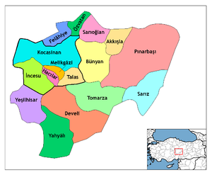
The city of Kayseri consists of sixteen metropolitan districts: Akkışla, Bünyan, Develi, Felâhiye, Hacılar, İncesu, Kocasinan, Melikgâzi, Özvatan, Pınarbaşı, Sarıoğlan, Sarız, Talas, Tomarza, Yahyâlı, and Yeşilhisar.
Economy


Kayseri received notable public investments in the 1920s and 1930s. Sumer Textile and Kayseri Tayyare Fabrikasi (airplane manufacturer) were set up here during the post Republican Era with the help of German and particularly Russian experts. The latter manufactured the first aircraft "made in Turkey" in the 1940s. After the 1950s, the city suffered from a decrease in the amount of public investment. It was, however, during the same years that Kayseri businessmen and merchants became transformed into countrywide capitalists. Families such as Sabancı, Has, Dedeman, Hattat, Kurmel, Özyeğin, Karamanlargil and Özilhan who started out as small-scale merchants in the city of Kayseri became prominent actors in the Turkish economy. These families set up their headquarters in cities such as Istanbul and Adana, nevertheless often coming back to Kayseri to invest.
Thanks to the economic liberalisation policies introduced in the 1980s, a new wave of merchants and industrialists from Kayseri joined their predecessors. Most of these new industrialists choose Kayseri as base of their operations. As a consequence of better infrastructures, the city achieved a remarkable industrial growth since 2000 and is one of the key cities that characterises the class of Anatolian Tigers, with a favourable environment present especially for small and medium enterprises.
The pace of growth of the city was so fast that in 2004 the city applied to the Guinness Book of World Records for the most new manufacturing industries started in a single day: 139 factories. Kayseri also has emerged as one of the most successful furniture-making hub in Turkey earned more than a billion dollars in export revenues in 2007.
Kayseri Free Zone established in 1998, today has more than 43 companies with an investment of 140 million dollars. The Zone's main business activities including; production, trading, warehouse management, mounting and demounting, assembly-disassembly, merchandising, maintenance and repair, engineering workshops, office and workplace rental, packing-repacking, banking and insurance, leasing, labelling and exhiption facilities. Kayseri FTZ with cost of $8 per square meter is one of the lowest cost land free zones in the world.[13]
Some social scientists trace this economic success to a modernist Islamic outlook referred to as "Islamic Calvinism" which they say is taking root in Kayseri.[14]
Transport


The city is served by Erkilet International Airport and the International Air Transport Association symbol for the airport is ASR. The airport is a short distance from the centre of Kayseri. There are several flights per day to Istanbul, Turkey's premium air transportation hub. Since the air transportation industry in Turkey is growing quickly, new flights from Kayseri to several other localities inside and outside Turkey are soon to be expected.
Kayseri is connected to the rest of country with railway service. There are four trains per day to Ankara. To the east there are two branches: one to Kars, and another to Tatvan on the west shore of Lake Van.
As the city is located in central Turkey, car and bus transportation are highly efficient. It takes approximately three hours to reach Ankara, approximately three hours to Mediterranean shores and 45 minutes to Cappadocia. The symbol of the city, Mount Erciyes, which is a notable ski centre in winters and accessible for trekking in summertime, is at only 30 minutes' drive from the city centre.
The transportation within the city relies mainly on buses, and personal vehicles. A light rail transit (LRT) system called Kayseray was constructed and completed by the end of 2009.
Sports
The city has two professional football teams competing in the top-flight of Turkish football: Kayserispor and Kayseri Erciyesspor, both playing in the Spor Toto Super League, making Kayseri one of the only two cities having more than one team in Spor Toto Süper Lig 2013–14, the other being Istanbul. Kayserispor is the only Turkish team to have won the UEFA Intertoto Cup, in 2006.
The Erciyes Ski Resort at Mount Erciyes is one of the largest ski resorts in Turkey.
The women's football club Kayseri Gençler Birliği was promoted to the Women's First League for the 2020-21 League season.[15]
Sports venues
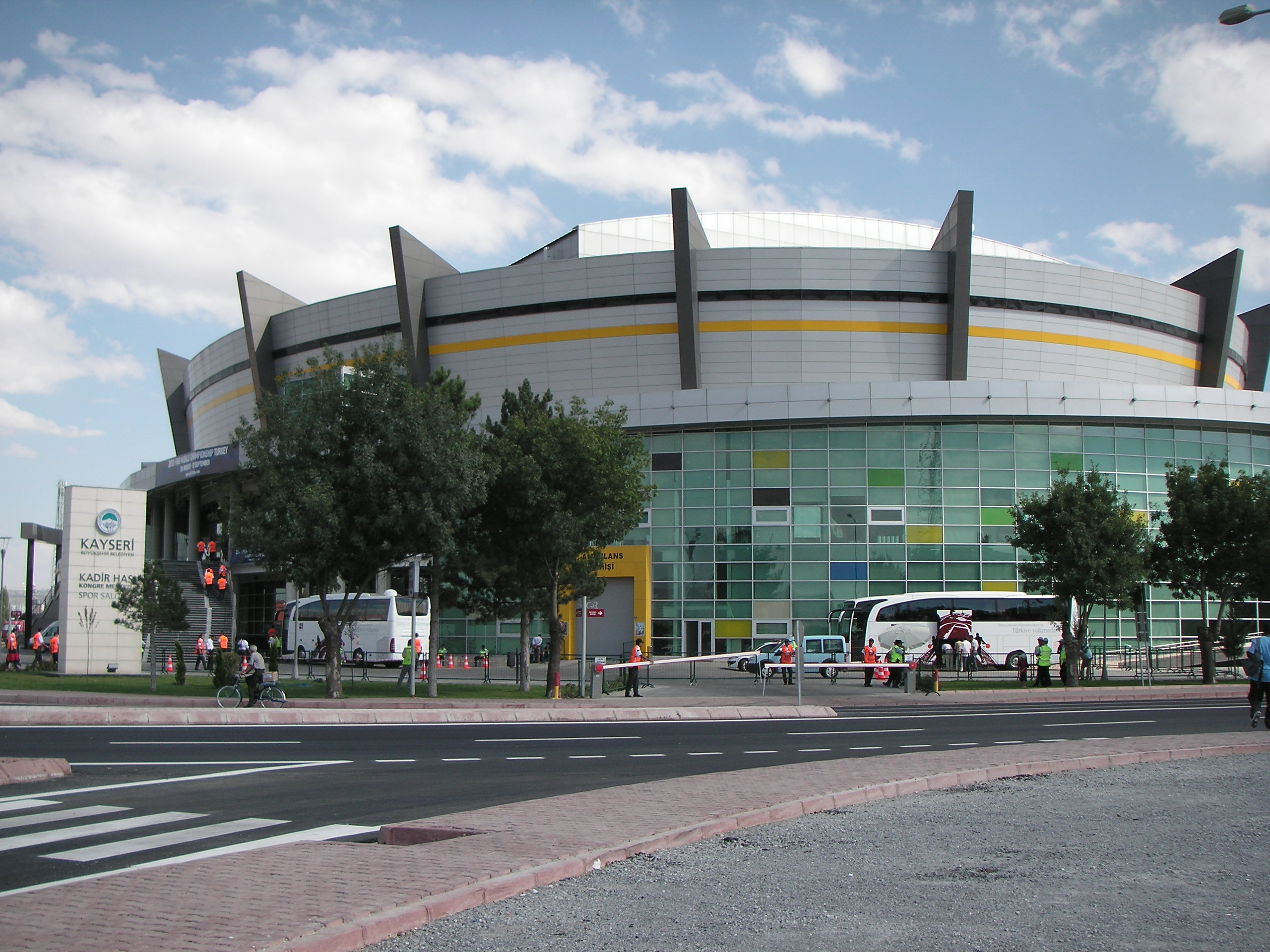
- Kadir Has Stadium is a new generation post-modern stadium, it is located in the outskirts of the city. The all-seater stadium has the capacity of 33,000 spectators and it is totally covered. It is shared by the two Kayserian football clubs, as before, and the Kadir Has Stadium is the new home for both teams. The stadium and surrounding sports complex are served by the light-rail system, Kayseray, making access to the complex easier for traveling locals. It was completed in early 2009. The inauguration of stadium was made with a Kayserispor – Fenerbahce league match. Kadir Has Stadium was one of the 8 host stadiums of the 2013 FIFA U-20 World Cup, The stadium hosted the opening ceremony followed by the opening match between Cuba versus the Republic of Korea.
- Kadir Has Sports Arena is an indoor arena complex, which was opened in 2008. It has a seating capacity of 7,200 people. Together with Kadir Has Stadium, it is a part of the Kayseri Kadir Has Sports Complex, one of the newest sports complexes in Turkey. The arena was one of the venues of the 2010 FIBA World Championship.

Education

Kayseri High School (Kayseri Lisesi), established in 1893, is one of the oldest high schools in Turkey. Küçükçalık Anatolian High School (Nuh Mehmet Küçükçalık Anadolu Lisesi), established in 1984, which is providing education in English, is among the first ones in Turkey. Kılıçarslan is a private high school in Kayseri, In 2000, it became a sister school with Anatolia College in Thessaloniki. TED Kayseri College in Kocasinan district of the city a Private, non-profit, co-educational kindergarten, primary, junior high, and high school is the third largest school in TED, since its foundation in 1966 thousands of students have graduated from the school.
Kayseri is home to 3 state and 1 private universities.
- Abdullah Gül University a newly established state university. AGU is the first state university in Turkey to have, as part of its constitution, legal provision for support by a foundation whose entire efforts are solely dedicated to the work of the university. The university started enrolling students in 2013.
- Erciyes University is the largest research university in the city founded in 1978 and is a continuation of a number of schools founded in 1206 and 1956,[16] currently serving with 13 faculties, six colleges and seven vocational schools. The university employs more than 3100 academic and administrative personnel and enrolls 41,225 students. The university is highly developed and thus well organised compared to the standards of Turkey.
- Nuh Naci Yazgan University is a private university founded in 2009 with four faculties, two colleges and one vocational school.
- Kayseri University
Cuisine

Kayseri is renowned for its culinary specialities such as mantı, pastırma and sucuk. Mantı is the most popular dish in Kayseri for the local people and tourists. Another speciality is stuffed zucchini flowers made with Köfte, garlic and spices. Nevzine is a traditional dessert.
Image gallery
 Döner Kümbet
 Kadir Has Stadium
 Kadir Has Stadium
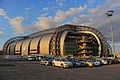 Kadir Has Stadium
 Kadir Has Stadium
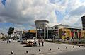 Forum Kayseri
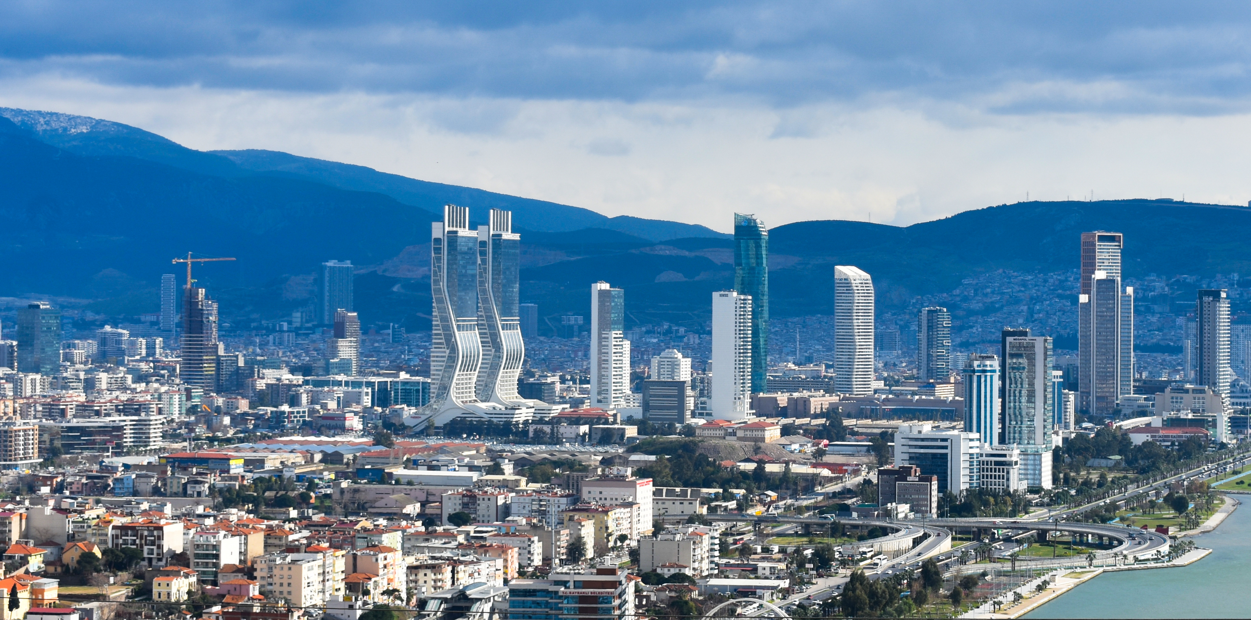
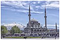 City view
 Kayseri clock Tower
 Traditional Mansion
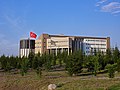 Erciyes University
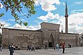 Hunat Hatun Medresesi dating from 1238
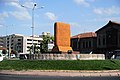 Statue of an Assyrian tablet
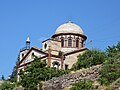 Former Greek church in Talas, now a mosque
 Erciyes mountain


Notable people
- Mimar Sinan (c. 1488/1490 – 1588), architect
- Kadi Burhan al-Din (1345–1398), Vizier and Atabeg of Eretnids
- Gevher Nesibe (13th century), Princess of the Sultanate of Rum
- Pavlos Karolidis (1849–1930), Greek historian and Member of the Ottoman Parliament
- Khachatur Kesaratsi (1590–1646), Armenian archbishop of New Julfa, founder of the first printing press in Iran
- Carrie Farnsworth Fowle (1854–1917), American missionary born in Kayseri
- Mihran Kassabian (1870–1910), Armenian radiologist
- Dikran Kelekian (1867–1951), Armenian art collector and dealer in Islamic art
- Hagop Kevorkian (1872–1962), Armenian archaeologist and art collector
Twin towns – sister cities
Kayseri is twinned with:[17]
See also
- Anatolian Tigers
References
- "Turkey: Administrative Division (Provinces and Districts) - Population Statistics, Charts and Map". Citypopulation.de.
- ESI. "Islamic Calvinists: Change and Conservatism in Central Anatolia" (PDF). European Stability Initiative, Berlin. Archived (PDF) from the original on 2005-12-10. Retrieved 2005-09-19.
- Olmstead, A. T. (1929). "Two Stone Idols from Asia Minor at the University of Illinois". Syria. 10 (4): 311–313. doi:10.3406/syria.1929.3413. JSTOR 4236961. Retrieved 30 June 2022 – via JSTOR.
- Everett-Heath, John (2005). Kayseri. Concise Dictionary of World Place-Names. Oxford University Press. Retrieved 2007-12-11.
- "Strabo, Geography, Book 12, chapter 2, section 7". Perseus.tufts.edu. Retrieved 30 June 2022.
- Ostrogorsky, George. History of the Byzantine State. New Jersey: Rutgers University Press, 1969. Pg 116.
- Ash, John (2006). A Byzantine journey ([2. ed.] ed.). London: Tauris Parke Paperbacks. p. 167. ISBN 9781845113070.
In that year the Turks captured Caesarea, the chief city of eastern Cappadocia, burnt it to the ground, massacred its inhabitants and descrated the great shrine of Saint Basil.
- Vaughan, Louis Bréhier ; translated by Margaret (1977). The life and death of Byzantium. Amsterdam: North-Holland Pub. Co . p. 193. ISBN 9780720490084.
In the spring of 1067 he invaded the Pontus and penetrated as far as Caesarea in Cappadocia which he demolished
- Speros Vryonis, Vryonis Decline of Medieval Hellinism in Asia Minor | PDF | Anatolia | Byzantine Empire The Decline of Medieval Hellenism in Asia Minor and the Process of Islamization from the Eleventh through the Fifteenth Century] Archived 2017-02-02 at the Wayback Machine (University of California Press, 1971), p. 155
- "Armenian Architecture – VirtualANI – The Traditional Houses of Kayseri". Virtualani.org. Archived from the original on 2007-05-23.
- "Resmi İstatistikler: İllerimize Ait Mevism Normalleri (1991–2020)" (in Turkish). Turkish State Meteorological Service. Retrieved 6 July 2021.
- "December Climate History for Kayseri | Local | Turkey". Myweather2.com. Archived from the original on 2012-03-20. Retrieved 2012-08-13.
- "KAYSER -Kayseri Serbest Bölgesi". Archived from the original on 2013-12-05.
- "Chronology of all ESI publications – Reports – ESI". Esiweb.org. 2005-09-19. Archived from the original on 2012-06-03. Retrieved 2012-08-13.
- "2019-2020 Sezonu Kadın Ligleri Yönetim Kurulu Kararı - 2- Kadınlar 2. Ligi" (in Turkish). Türkiye Futbol Federasyonu. 13 July 2020. Retrieved 10 October 2020.
- "Tarihçe". Archived from the original on 2021-07-28. Retrieved 2021-07-28.
- "Kayseri'nin Kardeş Şehirleri". kayseriyerelhaber.com (in Turkish). Kayseri Yerel Haber. 2014-11-07. Retrieved 2022-10-31.
- "Humus Kayseri". 2015-04-02. Archived from the original on 2016-12-27.
- "Шуша и Кайсери станут городами–побратимами". interfax.az (in Russian). Interfax Azerbaijan. 2021-04-13. Retrieved 2021-07-29.
External links
Largest cities or towns in Turkey TÜİK's address-based calculation from December 2017. | |||||||||||||||||||||||||||||||||||||||||||||||||||||||||||||||||||||||||||||||||||||||||||||
|---|---|---|---|---|---|---|---|---|---|---|---|---|---|---|---|---|---|---|---|---|---|---|---|---|---|---|---|---|---|---|---|---|---|---|---|---|---|---|---|---|---|---|---|---|---|---|---|---|---|---|---|---|---|---|---|---|---|---|---|---|---|---|---|---|---|---|---|---|---|---|---|---|---|---|---|---|---|---|---|---|---|---|---|---|---|---|---|---|---|---|---|---|---|
| |||||||||||||||||||||||||||||||||||||||||||||||||||||||||||||||||||||||||||||||||||||||||||||


Kayseri in Kayseri Province of Turkey | |||||||||||||||||||||||||||
|---|---|---|---|---|---|---|---|---|---|---|---|---|---|---|---|---|---|---|---|---|---|---|---|---|---|---|---|
| Districts |   | ||||||||||||||||||||||||||
|
Metropolitan municipalities are bolded. | |||||||||||||||||||||||||||
Authority control | |
|---|---|
| General | |
| National libraries | |
| Other |
|
На других языках
[de] Kayseri
Kayseri (lateinisch Caesarea, benannt zu Ehren des römischen Kaisers Tiberius; griechisch Καισάρεια .mw-parser-output .Latn{font-family:"Akzidenz Grotesk","Arial","Avant Garde Gothic","Calibri","Futura","Geneva","Gill Sans","Helvetica","Lucida Grande","Lucida Sans Unicode","Lucida Grande","Stone Sans","Tahoma","Trebuchet","Univers","Verdana"}Kaisareia, armenisch Կեսարիա Kesaria), zuvor Mazaka (armenisch Մաժաք Mazhak’, griechisch Μαζάκα) oder Eusebeia (griechisch Ἐυσεβεία), ist die Hauptstadt der gleichnamigen Provinz Kayseri in Kappadokien in der Türkei. Die Stadt hatte 2000 noch 536.392 Einwohner, die heutige Büyükşehir Belediyesi (deutsch etwa Großstadtkommune), die seit 2013 mit der Provinz Kayseri deckungsgleich ist, hat knapp 1,50 Mio. Einwohner (Stand 2020).- [en] Kayseri
[ru] Кайсери
Ка́йсери (Кесари́я, тур. Kayseri, греч. Καισάρεια, арм. Կեսարիա, Մաժաք, Kesaria, Mažakʿ, лат. Caesarea) — город в Турции, административный центр вилайета Кайсери, у северного подножия вулкана Эрджияс.Другой контент может иметь иную лицензию. Перед использованием материалов сайта WikiSort.org внимательно изучите правила лицензирования конкретных элементов наполнения сайта.
WikiSort.org - проект по пересортировке и дополнению контента Википедии