world.wikisort.org - Japan
Minamichita (南知多町, Minamichita-chō) is a town in Chita District, Aichi Prefecture, Japan. As of 1 October 2019[update], the town had an estimated population of 17,393 in 7338 households,[1] and a population density of 453 persons per km2. The total area of the town was 38.37 square kilometres (14.81 sq mi).
This article uses bare URLs, which are uninformative and vulnerable to link rot. (August 2022) |
Minamichita
南知多町 | |
|---|---|
Town | |
 Minamichita Town Hall | |
 Flag  Seal | |
 Location of Minamichita in Aichi Prefecture | |
 Minamichita | |
| Coordinates: 34°42′54.5″N 136°55′47.4″E | |
| Country | Japan |
| Region | Chūbu region Tōkai region |
| Prefecture | Aichi |
| District | Chita |
| Area | |
| • Total | 38.37 km2 (14.81 sq mi) |
| Population (October 1, 2019) | |
| • Total | 17,393 |
| • Density | 450/km2 (1,200/sq mi) |
| Time zone | UTC+9 (Japan Standard Time) |
| Phone number | 0569-65-0711 |
| Address | Toyohama, Minamichita-chō, Chita-gun, Aichi-ken 470-3495 |
| Climate | Cfa |
| Website | Official website |
| Symbols | |
| Flower | Narcissus |
| Tree | Quercus phillyraeoides (species of Oak) |
Geography
Minamichita is located in the extreme southern tip of Chita Peninsula in southern Aichi Prefecture, including a number of islands in Mikawa Bay. The town is bordered by Mikawa Bay to the east, and Ise Bay to the west. Part of the town's area are within the borders of the Mikawa Wan Quasi-National Park.
Neighboring municipalities
- Aichi Prefecture
Demographics
Per Japanese census data,[2] the population of Minamichita had been declining steadily over the past 70 years.
| Year | Pop. | ±% |
|---|---|---|
| 1940 | 22,741 | — |
| 1950 | 30,379 | +33.6% |
| 1960 | 28,972 | −4.6% |
| 1970 | 27,705 | −4.4% |
| 1980 | 27,017 | −2.5% |
| 1990 | 25,954 | −3.9% |
| 2000 | 23,250 | −10.4% |
| 2010 | 20,550 | −11.6% |
Climate
The town has a climate characterized by hot and humid summers, and relatively mild winters (Köppen climate classification Cfa). The average annual temperature in Minamichita is 15.7 °C (60.3 °F). The average annual rainfall is 1,550.1 mm (61.03 in) with September as the wettest month. The temperatures are highest on average in August, at around 27.2 °C (81.0 °F), and lowest in January, at around 5.2 °C (41.4 °F).[3]
| Climate data for Minamichita (1991−2020 normals, extremes 1979−present) | |||||||||||||
|---|---|---|---|---|---|---|---|---|---|---|---|---|---|
| Month | Jan | Feb | Mar | Apr | May | Jun | Jul | Aug | Sep | Oct | Nov | Dec | Year |
| Record high °C (°F) | 17.0 (62.6) |
21.0 (69.8) |
24.4 (75.9) |
28.9 (84.0) |
32.7 (90.9) |
34.8 (94.6) |
37.6 (99.7) |
38.3 (100.9) |
36.1 (97.0) |
30.4 (86.7) |
25.6 (78.1) |
23.1 (73.6) |
38.3 (100.9) |
| Average high °C (°F) | 9.1 (48.4) |
10.0 (50.0) |
13.5 (56.3) |
18.8 (65.8) |
23.2 (73.8) |
26.1 (79.0) |
30.0 (86.0) |
31.7 (89.1) |
28.0 (82.4) |
22.6 (72.7) |
16.9 (62.4) |
11.6 (52.9) |
20.1 (68.2) |
| Daily mean °C (°F) | 5.2 (41.4) |
5.6 (42.1) |
8.7 (47.7) |
13.7 (56.7) |
18.3 (64.9) |
21.9 (71.4) |
25.8 (78.4) |
27.2 (81.0) |
23.8 (74.8) |
18.3 (64.9) |
12.6 (54.7) |
7.6 (45.7) |
15.7 (60.3) |
| Average low °C (°F) | 1.3 (34.3) |
1.4 (34.5) |
4.1 (39.4) |
8.9 (48.0) |
13.9 (57.0) |
18.5 (65.3) |
22.7 (72.9) |
23.8 (74.8) |
20.5 (68.9) |
14.6 (58.3) |
8.5 (47.3) |
3.6 (38.5) |
11.8 (53.3) |
| Record low °C (°F) | −6.5 (20.3) |
−7.3 (18.9) |
−5.2 (22.6) |
−2.7 (27.1) |
2.9 (37.2) |
9.0 (48.2) |
14.6 (58.3) |
14.1 (57.4) |
8.8 (47.8) |
2.7 (36.9) |
−2.4 (27.7) |
−6.0 (21.2) |
−7.3 (18.9) |
| Average precipitation mm (inches) | 54.4 (2.14) |
59.3 (2.33) |
107.7 (4.24) |
122.2 (4.81) |
159.9 (6.30) |
187.7 (7.39) |
167.7 (6.60) |
106.8 (4.20) |
248.7 (9.79) |
201.2 (7.92) |
77.4 (3.05) |
57.2 (2.25) |
1,550.1 (61.03) |
| Average precipitation days (≥ 1.0 mm) | 5.4 | 6.1 | 9.2 | 9.5 | 10.1 | 12.3 | 10.9 | 7.3 | 10.5 | 10.0 | 6.6 | 5.9 | 103.8 |
| Mean monthly sunshine hours | 181.5 | 176.5 | 199.8 | 205.4 | 206.8 | 155.9 | 193.9 | 241.9 | 174.5 | 170.9 | 167.4 | 175.4 | 2,249.9 |
| Source: Japan Meteorological Agency[4][3] | |||||||||||||
History
The area of Minamichita was part of Owari Province and controlled by Owari Domain under the Edo period Tokugawa shogunate. It was a major port on the coastal trade route between Edo and Osawa. After the Meiji restoration, it was organized into villages within Chita District, Aichi with the establishment of the modern municipalities system.
The modern town of Minamichita was established on June 1, 1961, through the merger of the towns of Utsumi, Mihama, and Morozaki, and the villages of Shinojima and Himakajima, all within Chita District. During March 2006, discussions were held to merge Minamichita with the town of Mihama to the north to form the new city of “Minamicentrair” after the popular nickname for Chūbu Centrair International Airport, but the merger proposal was strongly opposed by the majority of the inhabitants of Minamichita, and the merger did not take place.[5]
Economy

The primary sector dominates the economy of Minamichita, notably commercial fishing and agriculture. Secondary industries include food processing, and seasonal tourism to beach resorts.
The Yamadera kiln (山寺窯) was located in Utsumi, today part of Minamichita. The kiln was active in the years Meiji 40 (1907) - Taishō 3 (1914). It produced Utsumi ware (内海焼).[6][7]
Education
Minamichita has six public elementary schools and five public junior high schools operated by the town government, and one high school operated by the Aichi Prefectural Board of Education.
Transportation
Railway
![]() Meitetsu – Chita New Line
Meitetsu – Chita New Line
Highways
 Minamichita Road
 National Route 247
Seaports
- Morogizaki Port
Local attractions
- Minamichita Onsen - hot spring resort
- Himakajima - island in Mikawa Bay
- Shinojima - island in Mikawa Bay
 Sightseeing farm Flower garden
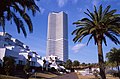 Citta Napoli
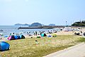 Himakajima
 Shinojima
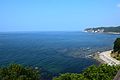 Cape Hazu


References
- Minamichita Town official statistics (in Japanese)
- Minamichita population statistics
- 気象庁 / 平年値(年・月ごとの値). JMA. Retrieved April 13, 2022.
- 観測史上1~10位の値(年間を通じての値). JMA. Retrieved April 13, 2022.
- "美浜町の概要". Mihama official home page (in Japanese). Retrieved 28 December 2015.
- "企画展「四代佐七と内海焼」 |TabiChita(タビチタ)|愛知県|知多半島観光圏協議会".
- http://minamichita.ed.jp/kyoikucho/2018/07/16/no-%EF%BC%91%EF%BC%99%EF%BC%93%EF%BC%99%E3%80%80%E3%80%80%E5%86%85%E7%94%B0%E5%AE%B6%E4%BC%81%E7%94%BB%E5%B1%95%E3%80%80%E3%80%8C%E5%9B%9B%E4%BB%A3%E4%BD%90%E4%B8%83%E3%81%A8%E5%86%85%E6%B5%B7/
External links
Nagoya (capital) | ||||
| Nagoya |
| |||
| Core cities |
| |||
| Special city | ||||
| Cities | ||||
| Districts | ||||
| ||||
Authority control | |
|---|---|
| General | |
| National libraries | |
На других языках
- [en] Minamichita
[ru] Минамитита
Минамитита (яп. 南知多町 Минамитита-тё:) — посёлок в Японии, находящийся в уезде Тита префектуры Айти. Площадь посёлка составляет 38,25 км²[1], население — 19 068 человек (1 июня 2014)[2], плотность населения — 498,51 чел./км².Другой контент может иметь иную лицензию. Перед использованием материалов сайта WikiSort.org внимательно изучите правила лицензирования конкретных элементов наполнения сайта.
WikiSort.org - проект по пересортировке и дополнению контента Википедии