 "Pottery Footpath" (Yakimono-sanpomichi)
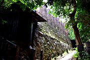 The Tōei kiln, largest climbing kiln (nobori-gama) in Japan
 INAX MUSEUMS
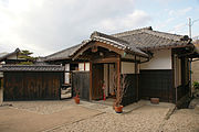 Old residence of the Takita shipping family
world.wikisort.org - Japan
Tokoname (常滑市, Tokoname-shi) is a city in Aichi Prefecture, Japan. As of 1 October 2019[update], the city had an estimated population of 57,872 in 24,872 households,[1] and a population density of 1,035 persons per km². The total area of the city is 55.90 square kilometres (21.58 sq mi).
Tokoname
常滑市 | |
|---|---|
City | |
 Tokoname ware tiles | |
 Flag  Emblem | |
 Location of Tokoname in Aichi Prefecture | |
 Tokoname | |
| Coordinates: 34°53′11.5″N 136°49′56.4″E | |
| Country | Japan |
| Region | Chūbu (Tōkai) |
| Prefecture | Aichi |
| Government | |
| • Mayor | Tatsuya Itō |
| Area | |
| • Total | 55.90 km2 (21.58 sq mi) |
| Population (October 1, 2019) | |
| • Total | 57,872 |
| • Density | 1,000/km2 (2,700/sq mi) |
| Time zone | UTC+9 (Japan Standard Time) |
| Phone number | 0569-35-5111 |
| Address | 4-1 Shinkai-chō, Tokoname-shi, Aichi-ken 479-0837 |
| Climate | Cfa |
| Website | Official website |
| Symbols | |
| Flower | Camellia sasanqua |
| Tree | Japanese Black Pine |
Geography

Tokoname is located on the western coast of the Chita Peninsula in southern Aichi Prefecture, facing Ise Bay.
Climate
The city has a climate characterized by hot and humid summers, and relatively mild winters (Köppen climate classification Cfa). The average annual temperature in Tokoname is 15.5 °C. The average annual rainfall is 1674 mm with September as the wettest month. The temperatures are highest on average in August, at around 27.4 °C, and lowest in January, at around 4.6 °C.[2]
| Climate data for Chubu Centrair International Airport, Tokoname (2005−2020 normals, extremes 2005−present) | |||||||||||||
|---|---|---|---|---|---|---|---|---|---|---|---|---|---|
| Month | Jan | Feb | Mar | Apr | May | Jun | Jul | Aug | Sep | Oct | Nov | Dec | Year |
| Record high °C (°F) | 16.3 (61.3) |
19.6 (67.3) |
22.9 (73.2) |
27.1 (80.8) |
30.3 (86.5) |
34.6 (94.3) |
35.6 (96.1) |
36.1 (97.0) |
35.6 (96.1) |
30.1 (86.2) |
24.3 (75.7) |
20.8 (69.4) |
36.1 (97.0) |
| Average high °C (°F) | 9.1 (48.4) |
9.7 (49.5) |
13.0 (55.4) |
17.9 (64.2) |
22.7 (72.9) |
25.7 (78.3) |
29.3 (84.7) |
31.2 (88.2) |
27.7 (81.9) |
22.6 (72.7) |
17.1 (62.8) |
11.6 (52.9) |
19.8 (67.7) |
| Daily mean °C (°F) | 6.3 (43.3) |
6.6 (43.9) |
9.3 (48.7) |
13.9 (57.0) |
18.8 (65.8) |
22.5 (72.5) |
26.1 (79.0) |
27.8 (82.0) |
24.6 (76.3) |
19.6 (67.3) |
14.2 (57.6) |
8.8 (47.8) |
16.5 (61.8) |
| Average low °C (°F) | 3.1 (37.6) |
3.2 (37.8) |
5.7 (42.3) |
10.2 (50.4) |
15.4 (59.7) |
19.9 (67.8) |
23.7 (74.7) |
25.2 (77.4) |
21.8 (71.2) |
16.5 (61.7) |
10.7 (51.3) |
5.6 (42.1) |
13.4 (56.2) |
| Record low °C (°F) | −3.1 (26.4) |
−3.0 (26.6) |
−0.6 (30.9) |
1.7 (35.1) |
8.4 (47.1) |
13.7 (56.7) |
18.7 (65.7) |
19.6 (67.3) |
14.0 (57.2) |
9.6 (49.3) |
3.5 (38.3) |
−1.2 (29.8) |
−3.1 (26.4) |
| Average precipitation mm (inches) | 42.1 (1.66) |
61.3 (2.41) |
95.1 (3.74) |
112.8 (4.44) |
130.4 (5.13) |
166.4 (6.55) |
164.0 (6.46) |
88.3 (3.48) |
177.8 (7.00) |
179.0 (7.05) |
60.8 (2.39) |
53.4 (2.10) |
1,363.5 (53.68) |
| Average precipitation days (≥ 1.0 mm) | 4.9 | 6.2 | 8.3 | 8.6 | 9.1 | 10.8 | 10.9 | 7.0 | 10.4 | 9.0 | 6.0 | 5.8 | 97 |
| Source: JMA[3][4] | |||||||||||||
Demographics
Per Japanese census data,[5] the population of Tokoname has been relatively steady over the past 50 years.
| Year | Pop. | ±% |
|---|---|---|
| 1960 | 51,919 | — |
| 1970 | 54,168 | +4.3% |
| 1980 | 54,343 | +0.3% |
| 1990 | 51,784 | −4.7% |
| 2000 | 50,183 | −3.1% |
| 2010 | 54,858 | +9.3% |
Neighboring municipalities
 Aichi Prefecture
History
Ancient history
Tokoname has been associated with ceramics production since at least the Heian period, and Tokoname-yaki works from this period have been found in locations as far away as Aomori Prefecture in the north of Japan and Kagoshima prefecture in the south.
Middle Ages
By the Kamakura period, over 3000 kilns were active. During the Sengoku period, the area came under the control of the Isshiki clan, and later came under the rule of Oda Nobunaga and Toyotomi Hideyoshi.
Early modern period
During the Edo period, the area around present-day Tokoname was part of Owari Domain.
Late modern period
In the post Meiji Restoration cadastral reforms of 1889, the town of Tokoname was created with the establishment of the modern municipalities system.
Contemporary history
Tokoname was elevated to city status on April 1, 1954, by the merger of Tokoname town with the towns of Onizaki (鬼崎), Nishiura (西浦) and Ōno (大野), and the village of Miwa (三和村).
Government

Tokoname has a mayor-council form of government with a directly elected mayor and a unicameral city legislature of 18 members. The city contributes one member to the Aichi Prefectural Assembly. In terms of national politics, the city is part of Aichi District 8 of the lower house of the Diet of Japan.
Chubu Centrair International Airport, built on an artificial island off the coast of Tokoname, opened on February 17, 2005, providing a major boost to local development.
External relations
Twin towns – sister cities
International
- Friendship city
 Yixing(Jiangsu, China)
- since April 25, 2018
Economy
Secondary sector of the economy
Ceramic engineering
Tokoname is a regional commercial center, and has been known since the Heian period for its production of ceramics, notably Tokoname-yaki, and ceramics production remains the mainstay of the local economy. One of the main producing companies is INAX.
About 60 climbing kilns formerly operated, most of which were constructed starting in the Meiji era. The chimneys became a landmark of the town, but many were closed and taken down after the Second World War as production methods modernised and burning of ovens was regulated by the authorities to protect the air quality. The Tōei Kiln (陶栄窯) is a climbing kiln (nobori-gama) that was constructed in 887 and used until 1974. It is the largest climbing kiln existing in Japan. It was designated as an Important Tangible Cultural Property by the government in 1982. It has eight firing chambers running a 17° incline and ten chimneys of varying height.
With its long coastline, commercial fishing also plays an important role in the local economy.


Education
Tokoname has nine public elementary schools, four public junior high schools operated by the city government, and one public high school operated by the Aichi Prefectural Board of Education.
High school
- Tokoname Senior High School
Junior high schools
- Tokoname Junior High School
- Onizaki Junior High School
- Nanryo Junior High School
- Seikai Junior High School
Elementary schools
- Miwa Elementary School
- Ono Elementary School
- Onizaki North Elementary School
- Onizaki South Elementary School
- Tokoname West Elementary School
- Tokoname East Elementary School
- Nishiura North Elementary School
- Nishiura South Elementary School
- Kosugaya Elementary School
Transportation


Airways
Airport
- Chūbu Centrair International Airport
Railways
Conventional lines
 Meitetsu
- Tokoname Line:- Ōnomachi – Nishinokuchi – Kabaike – Enokido – Taya – Tokoname
- Airport Line:Tokoname – Rinkū-Tokoname – Central Japan International Airport
Buses
Bus services
- Chita Bus (Chita Noriai)
- Kariya-Central Japan International Airport Route
- Tokoname Route
- Chintahanda – Narawabashi – Tokoname – Central Japan International Airport /- RinkuTokoname – Tokoname – Tokoname Public Hospital
- Tokoname South Route
- Kaminomae – Tokoname – *Central Japan International Airport/ – RinkuTokoname – Tokoname – Tokoname Public Hospital
- *All passengers going to Central Japan International Airport need to get a transfer ticket and change to Tokoname Route Services at Tokoname Station.
- Tokoname City North Bus
- Tokoname Municipal Government – Tokoname – Tokoname Public Hospital – YadaCentral – Ogura Public Hall
Roads
Expressway
 Chitaōdan Road (Tollroad)
- Chubu International Airport Connecting Road (Tollroad)
Japan National Route
 National Route 155
 National Route 247
Local attractions
- Inax Museum
- Akio Morita Library
- Ōno Castle
 Ōno beach
 Ōno Festival
 Ōno Castle
 Akio Morita Library


Notable people from Tokoname
- Tetsuzō Tanikawa, philosopher, father of Shuntarō Tanikawa
- Kotaro Suzumura, economist
- The Peanuts, singers
- Tatsutoshi Goto, professional wrestler
- Tetsu Watanabe, actor
- Shibayama Tomotaka, anime director of the 2020 A Whisker Away, which takes place in Tokoname[6][7][8]
References
- Tokoname City official statistics (in Japanese)
- Tokoname climate data
- 観測史上1~10位の値(年間を通じての値). JMA. Retrieved March 1, 2022.
- 気象庁 / 平年値(年・月ごとの値). JMA. Retrieved March 1, 2022.
- Tokoname population statistics
- "A Whisker Away: Netflix release date and trailer". May 2020.
- "You can now visit the setting of "A Whisker Away" in Tokoname, Aichi Prefecture".
- "You Can Now Visit Real-Life Locations of 'A Whisker Away' in Japan".
External links
![]() Media related to Tokoname at Wikimedia Commons
Media related to Tokoname at Wikimedia Commons
- Official website (in Japanese) (with link to pages in English)
Authority control | |
|---|---|
| General | |
| National libraries | |
| Scientific databases | |
| Other |
|
Nagoya (capital) | ||||
| Nagoya |
| |||
| Core cities |
| |||
| Special city | ||||
| Cities | ||||
| Districts | ||||
| ||||
На других языках
- [en] Tokoname
[es] Tokoname (Aichi)
Tokoname (常滑市, Tokoname-shi?) es una ciudad que se encuentra al sur de la Prefectura de Aichi, Japón. Se ubica al oeste de la península de Chita, que separa la bahía de Ise con la bahía de Mikawa.[ru] Токонамэ
Токонамэ́ (яп. 常滑市 Токонамэ-си) — город в Японии, расположенный в юго-восточной части префектуры Айти на полуострове Тита на берегу залива Исе. Основан 1 апреля 1954 года путём объединения посёлков Токонамэ, Онидзаки, Нисиура, Оно и села Мива уезда Тита. Город является центром фарфоро-фаянсовой промышленности. Население состоянием на 2014 год составляет 56 737 человек, с площадью 55,63км².Текст в блоке "Читать" взят с сайта "Википедия" и доступен по лицензии Creative Commons Attribution-ShareAlike; в отдельных случаях могут действовать дополнительные условия.
Другой контент может иметь иную лицензию. Перед использованием материалов сайта WikiSort.org внимательно изучите правила лицензирования конкретных элементов наполнения сайта.
Другой контент может иметь иную лицензию. Перед использованием материалов сайта WikiSort.org внимательно изучите правила лицензирования конкретных элементов наполнения сайта.
2019-2026
WikiSort.org - проект по пересортировке и дополнению контента Википедии
WikiSort.org - проект по пересортировке и дополнению контента Википедии