world.wikisort.org - Japan
Shitara (設楽町, Shitara-chō) is a town located in Kitashitara District, Aichi Prefecture, Japan. As of 1 October 2019[update], the town had an estimated population of 4,531 in 2,133 households,[1] and a population density of 16.5 persons per km². The total area of the town was 273.94 square kilometres (105.77 sq mi).
Shitara
設楽町 | |
|---|---|
Town | |
 Shitara Town Hall and Library | |
 Flag  Emblem | |
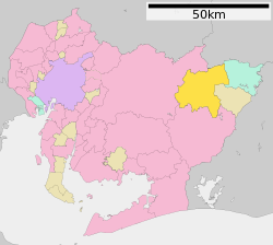 Location of Shitara in Aichi Prefecture | |
 Shitara | |
| Coordinates: 35°6′N 137°34′E | |
| Country | Japan |
| Region | Chūbu region Tōkai region |
| Prefecture | Aichi |
| District | Kitashitara |
| Government | |
| • -Mayor | Kazutoshi Kato |
| Area | |
| • Total | 273.94 km2 (105.77 sq mi) |
| Population (October 1, 2019) | |
| • Total | 4,531 |
| • Density | 17/km2 (43/sq mi) |
| Time zone | UTC+9 (Japan Standard Time) |
| - Tree | Japanese beech |
| - Flower | Rhododendron |
| Phone number | 0536-62-0511 |
| Address | 2 Idate, Taguti, Shitara-chō, Kitashitara-gun, Aichi-ken 441-2301 |
| Website | Official website |

Geography
Shitara is located in the extreme northeast corner of Aichi Prefecture. Much of the town’s area is covered by mountains and forest, and portions of the town are within the borders of the Tenryū-Okumikawa Quasi-National Park.
Neighboring municipalities
Aichi Prefecture
- Shinshiro
- Toyota
- Kitashitara District
- Toyone
- Toei
Nagano Prefecture
- Shimoina District
- Neba
Demographics
Per Japanese census data,[2] the population of Shitara has decreased drastically and is only a third of what it was 60 years ago.
| Year | Pop. | ±% |
|---|---|---|
| 1960 | 14,975 | — |
| 1970 | 10,732 | −28.3% |
| 1980 | 9,321 | −13.1% |
| 1990 | 8,225 | −11.8% |
| 2000 | 6,959 | −15.4% |
| 2010 | 5,767 | −17.1% |
Climate
The town has a climate characterized by hot and humid summers, and relatively mild winters (Köppen climate classification Cfa). The average annual temperature in Shitara is 11.9 °C. The average annual rainfall is 2310 mm with September as the wettest month. The temperatures are highest on average in August, at around 23.6 °C, and lowest in January, at around 0.3 °C.[3]
History
During the Edo period, most of present Shitara was tenryō territory under direct control of the Tokugawa shogunate. After the Meiji Restoration, the area was organized into several villages within Kitashitara District with the establishment of the modern municipalities system. Taguchi Village, the site of the district administrative office, was elevated to town status on October 10, 1900. The town of Shitara was established on September 30, 1956 through the merger of Taguchi with the neighboring villages of Damine, Nagura and Furikusa. The village of Tsugu was also formed on the same day through the merger of Kamitsugu and Shimotsugu villages. Shitara and Tsugu merged on October 1, 2005.
Economy
The primary industry of Shitara is agriculture, with rice, tomatoes, cabbage and daikon as the main crops. Production of hydroelectric power generation is also a major contributor to the local economy.
Education
Shitara has five public elementary schools and two public junior high schools operated by the city government, and one public high school operated by the Aichi Prefectural Board of Education.
Primary schools
- Taguchi Primary School
- Seirei Primary School
- Damine Primary School
- Nagura Primary School
- Tsugu Primary School
Junior High schools
- Shitara Junior High School
- Tsugu Junior High School
High schools
- Taguchi High School
Foreign Exchange Program
- Thomas Middle School (Arlington Heights, IL, USA)
- South Middle School (Arlington Heights, IL, USA)
Transportation
Railway
Shitara does not have any passenger railway services.
Highway
 National Route 257
 National Route 420
 National Route 473
Local attractions
- Kurabune Ruins (鞍船遺跡) – Jōmon period archaeological site excavated in 1922
- Damine Castle (田峯城) – ruins of a Sengoku period castle
- Soezawa Onsen - hot spring resort
Notable people from Shitara
- Mitsuzo Sasaki, author
References
External links
![]() Media related to Shitara, Aichi at Wikimedia Commons
Media related to Shitara, Aichi at Wikimedia Commons
Nagoya (capital) | ||||
| Nagoya |
| |||
| Core cities |
| |||
| Special city | ||||
| Cities | ||||
| Districts | ||||
| ||||
На других языках
- [en] Shitara, Aichi
[ru] Ситара (Япония)
Ситара (яп. 設楽町 Ситара-тё:) — посёлок в Японии, находящийся в уезде Китаситара префектуры Айти. Площадь посёлка составляет 273,96 км²[1], население — 5172 человека (1 июня 2014)[2], плотность населения — 18,88 чел./км².Другой контент может иметь иную лицензию. Перед использованием материалов сайта WikiSort.org внимательно изучите правила лицензирования конкретных элементов наполнения сайта.
WikiSort.org - проект по пересортировке и дополнению контента Википедии