world.wikisort.org - Japan
Matsukawa (松川町, Matsukawa-machi) is a town located in Nagano Prefecture, Japan. As of 1 April 2019[update], the town had an estimated population of 13,043 in 4364 households,[1] and a population density of 180 persons per km². The total area of the town is 72.79 square kilometres (28.10 sq mi). Like many other small Southern Nagano villages, it is famous for its apples.
Matsukawa
松川町 | |
|---|---|
Town | |
 Matsukawa Town Hall | |
 Flag  Seal | |
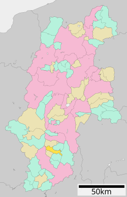 Location of Matsukawa in Nagano Prefecture | |
 Matsukawa | |
| Coordinates: 35°35′50″N 137°54′34.8″E | |
| Country | Japan |
| Region | Chūbu (Kōshin'etsu) |
| Prefecture | Nagano |
| District | Shimoina |
| Area | |
| • Total | 72.79 km2 (28.10 sq mi) |
| Population (April 2019) | |
| • Total | 13,043 |
| • Density | 180/km2 (460/sq mi) |
| Time zone | UTC+9 (Japan Standard Time) |
| Symbols | |
| • Tree | Pine |
| • Flower | Pyrus pyrifolia |
| Phone number | 0265-36-3111 |
| Address | 3823 Oshima, Matsukawa-machi, Shimoina-gun, Nagano-ken 399-3303 |
| Website | Official website |

Geography
Located in the Ina Basin of mountainous southern Nagano Prefecture, Matsukawa is bordered to the west by the Kiso Mountains. The town stretches for 21 kilometers east-west, but is only 6 kilometers wide north-south. The Tenryū River passes through center of the town.
Surrounding municipalities
Climate
The town has a climate characterized by hot and humid summers, and cold winters (Köppen climate classification Cfa). The average annual temperature in Matsukawa is 12.2 °C. The average annual rainfall is 1583 mm with September as the wettest month. The temperatures are highest on average in August, at around 24.65 °C, and lowest in January, at around 0.2 °C.[2]
Demographics
Per Japanese census data,[3] the population of Matsukawa has remained relatively steady over the past 80 years.
| Year | Pop. | ±% |
|---|---|---|
| 1940 | 11,042 | — |
| 1950 | 13,431 | +21.6% |
| 1960 | 12,595 | −6.2% |
| 1970 | 12,411 | −1.5% |
| 1980 | 13,108 | +5.6% |
| 1990 | 13,422 | +2.4% |
| 2000 | 14,070 | +4.8% |
| 2010 | 13,678 | −2.8% |
| 2020 | 12,530 | −8.4% |
History
The area of present-day Matsukawa was part of ancient Shinano Province. The modern town was established on September 20, 1956 by the merger of the village of Oshima in Shimoina District with the village of Katagiri in Kamiina District
Education
Matsukawa has one public elementary school, one public middle school and one public combined elementary/middle school operated by the town government. The town also has one public high school operated by the Nagano Prefectural Board of Education.
Transportation
Railway
 JR Tōkai – Iida Line
- Kamikatagiri - Ina-Ōshima
Highway
 National Route 153
Local attractions
- Kataoka Dam
References
External links
 Media related to Matsukawa, Nagano (town) at Wikimedia Commons
- Official Website (in Japanese)
Authority control | |
|---|---|
| General | |
| National libraries | |
| Other |
|
Nagano (capital) | |
| Core cities | |
| Cities | |
| Districts |
|
List of mergers in Nagano Prefecture | |
This Nagano Prefecture location article is a stub. You can help Wikipedia by expanding it. |
На других языках
[de] Matsukawa (Shimoina)
Matsukawa (jap. 松川町, -machi) ist eine Kleinstadt im Landkreis Shimoina der Präfektur Nagano auf der japanischen Hauptinsel Honshū.- [en] Matsukawa, Nagano (Shimoina)
[ru] Мацукава (посёлок)
Мацукава (яп. 松川町 Мацукава-мати) — посёлок в Японии, находящийся в уезде Симоина префектуры Нагано. Площадь посёлка составляет 72,90 км²[1], население — 13 325 человек (1 августа 2014)[2], плотность населения — 182,78 чел./км².Другой контент может иметь иную лицензию. Перед использованием материалов сайта WikiSort.org внимательно изучите правила лицензирования конкретных элементов наполнения сайта.
WikiSort.org - проект по пересортировке и дополнению контента Википедии