world.wikisort.org - Indonesia
Kupang (Indonesian: Kota Kupang, Indonesian pronunciation: [ˈkupaŋ]), formerly known as Koepang, is the capital of the Indonesian province of East Nusa Tenggara. As of 2020, it had a population of 442,758.[4] It is the largest city and port on the island of Timor, and is a part of the Timor Leste-Indonesia-Australia Growth Triangle free trade zone.[5] Geographically, Kupang is the southernmost city in Indonesia.
Kupang | |
|---|---|
City | |
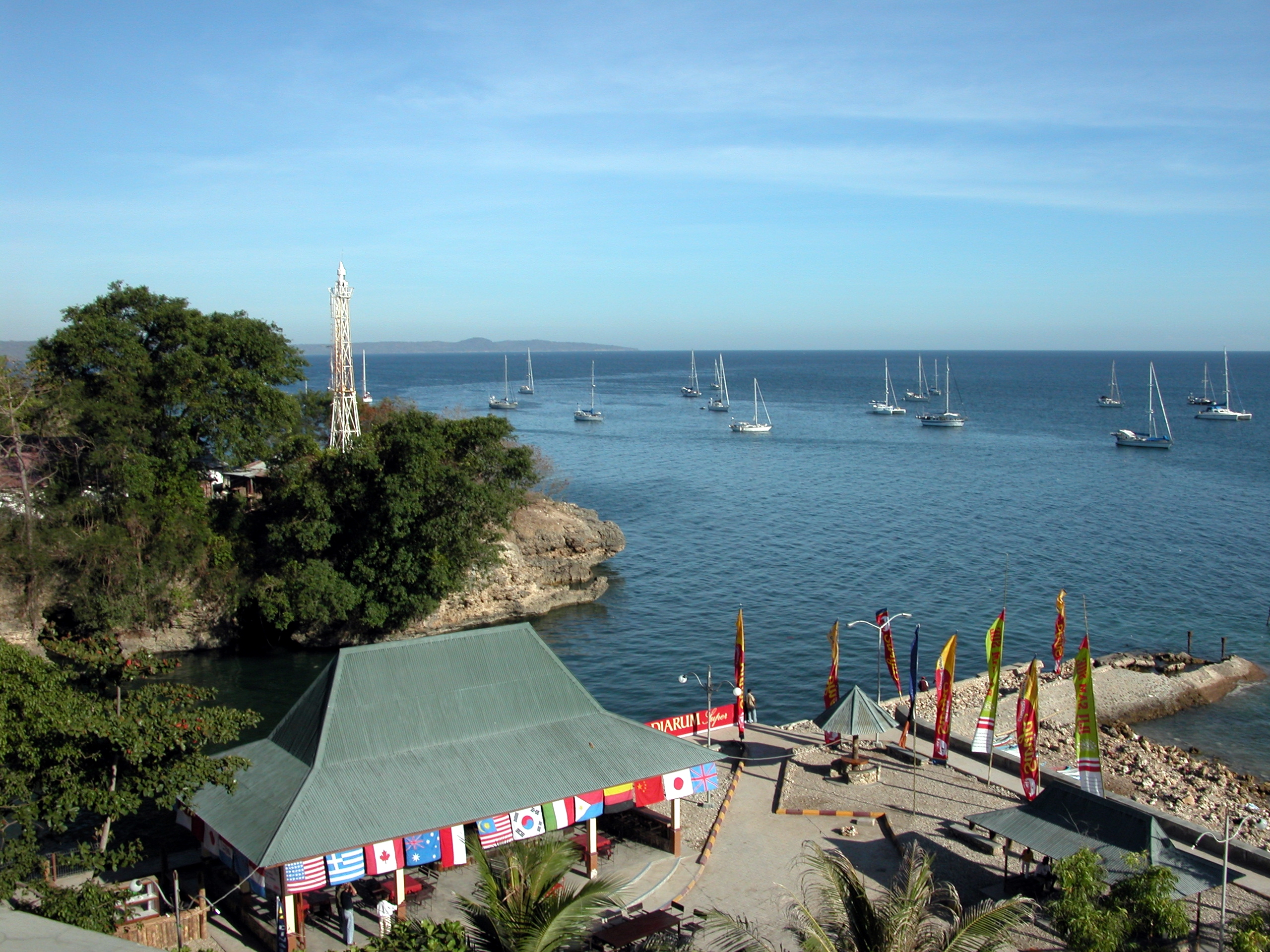
Clockwise, from above; Sasando Building, Kupang seen from above, and Kupang lighthouse | |
 Flag Coat of arms | |
| Motto(s): | |
 Location within East Nusa Tenggara | |
| Coordinates: 10°10′12.6″S 123°36′27.9″E | |
| Country | |
| Province | |
| Founded | 1886 |
| Government | |
| • Mayor | Jefri Riwu Kore |
| • Vice Mayor | Hermanus Man |
| Area | |
| • Total | 180.27 km2 (69.60 sq mi) |
| Elevation | 62 m (203 ft) |
| Population (2020 Census) | |
| • Total | 442,758 |
| • Density | 2,500/km2 (6,400/sq mi) |
| [2] | |
| Time zone | UTC+8 (Central Indonesia Standard Time) |
| Area code | (+62) 380 |
| Vehicle registration | DH |
| HDI (2018) | |
| Website | kupangkota |


History


Early history and Portuguese domination
Kupang was an important port and trading post during the Portuguese and Dutch colonial eras. There are still ruins and remnants of the colonial presence in the city.
Representatives of the Dutch East India Company (VOC) first encountered Kupang in 1613 after having conquered the Portuguese fort on the island of Solor. At this time the area of the city was governed by a Raja of the Helong tribe, who claimed descent from the island of Ceram in the Maluku archipelago. Kupang occupied an ideal strategic position to exercise control over parts of Timor since it was possible to monitor shipping activities along the south coast of the island from the location. Moreover, the Koinino River provided a supply of fresh water for the city.
An agreement was reached between the VOC and the Helong tribe, but due to a lack of VOC presence on Timor, Kupang was heavily influenced by the Portuguese mestizo population of Flores, the Topasses, which led to the establishment of a Portuguese stronghold by the 1640s. However, by 1646, the VOC was firmly established on the nearby island of Solor, and renewed their agreement with the local Raja of Kupang.[6] In January 1653, a Dutch fortification, Fort Concordia, was built on an elevated position on the left bank of the river estuary. Kupang then became the base of the Dutch struggle against the Portuguese. After a series of defeats were inflicted on the Dutch in between 1655 and 1657, large groups of refugees from the neighbouring VOC allies of the Sonbai and Amabi principalities settled into the vicinity of Kupang and formed small polities on land that had traditionally belonged to the Helong. They were followed by two other groups, the Amfoan and the Taebenu, who arrived in 1683 and 1688, respectively. The Helong Raja remained the "Lord of the Land" (tuan tanah) but remained closely dependent on VOC authorities. However, apart from the territory of the Helong, the island of Timor was largely dominated by the Portuguese until 1749.[7]
Dutch colony
The Dutch established a European-modelled administration with a chief executive (opperhoofd) and a council, which regulated affairs with the indigenous population through regular meetings (vergaderingen), and which also handled affairs with the nearby VOC-allied islands of Rote, Savu, and Solor. Chinese traders and artisans were settled by the early 18th century and soon became an indispensable part of the local economy. The area of the town was also settled by various indigenous groups from the region, and by mardijkers (who were the descendants of freed slaves under Dutch jurisdiction). In 1752, the population consisted of 827 Christians and an unspecified number of non-Christians.[8] The political importance of Kupang increased greatly in 1749 when the Topasses were decisively defeated by the Dutch and their allies, which led to the extension of VOC influence over wide areas of western and central Timor. Nevertheless, Dutch influence on the island was somewhat diminished after 1761 due to incompetence and inaction on part of the colonial administration.
Kupang was the final destination of William Bligh, who was set adrift in an open boat following the Mutiny on the Bounty (1789). After travelling 3,618 nautical miles (6,710 km) from the Tonga Islands over 41 days, Bligh landed in Kupang on 14 June.[9] News of his journey inspired a small party of nine convicts and two children to escape from the penal colony at Sydney Cove, Australia, who escaped from Port Jackson, Australia, and arrived at Kupang after ten weeks,[10] having travelled 3,254 nautical miles (6,026 km).[11]
VOC positions in the East Indies were attacked by British Forces following the occupation of the Netherlands by French revolutionary armies in 1795. Kupang was assaulted in 1797, and the British were eventually expelled, although the town suffered extensive damage. Another British attack in 1811 was similarly defeated. After the British occupation of Java, Kupang finally surrendered in January 1812, and the town was returned to the Dutch in 1816 following the end of the Napoleonic Wars.
The politics of the city in the early 19th century were dominated by Jacobus Arnoldus Hazaart, who governed Dutch Timor as Resident in three terms between 1810 and 1832, and handled matters with little intereference from the colonial government in Batavia.[12] During his tenure the Christian mission in the city experienced greater success than before, partially through the efforts of the missionary Reint LeBruyn (1799-1829). The town was opened to foreign trade in 1825, and fees were abolished three years later. Kupang's subsequent popularity with British and North American whalers was diminished by the late 19th century after the relocation of whaling areas, although the city was a free port after 1866.[13] In 1917, the five small kingdoms that surrounded the town area (the Helong kingdoms of Kupang, Sonbai Kecil, Amabi, Taebenu and Funai) were merged into the zelfbesturend landschap (self-ruling territory) of Kupang in 1917, which, in spite of the name, did not include the city itself. From 1918 to 1955 Kupang was governed by the Nisnoni family, a branch of the Sonbai Dynasty.[14]
Recent history and independence
The city was used for landing and refueling by long-distance flights between Europe and Australia. It was under Japanese occupation between 1942 and 1945, and much of the Old Town was destroyed by Allied bombing. The city saw significant nationalist agitation but remained otherwise peaceful during the period of the Indonesian revolution (1945-1949). Kupang was later part of the State of East Indonesia that was established by the Dutch authorities in 1946, and the area of the city was included in the zelfbesturend landschap of Kupang. The city, along with the state of East Indonesia was later annexed into the United States of Indonesia in 1949, which was replaced by the current Republic of Indonesia in 1950.
The city later became an important location in the Timorese conflict. In 1967, the city became the seat of the Diocese of Kupang. In 1989, the diocese was elevated to the Archdiocese of Kupang.[15] In April 2021, the city was heavily damaged by Tropical Cyclone Seroja.[16]
Geography
Kupang is located in the southwestern tip of the island of Timor. It is solely bordered by the Kupang Regency on land, and on its northern shore by the Savu Sea. It has a land area of 180.27 square kilometers (which is divided into six administrative districts), along with a water area of 94.79 square kilometers. The area around the city is geologically inactive, with soil composition characterised by non-volcanic materials such as Latosol and Terra rossa. At its highest point, the city is 62 metres above sea level, with inclination varying from 0 - 5%.[4] The topography of the city is mostly low-lying, but also includes groups of hills in the south and southwest, which has the effect of creating a relatively fertile catchment area.[17][4]
Climate
Under the Köppen climate classification, Kupang has a tropical savanna climate (Aw). Unlike many cities with this climate, Kupang's temperature varies little between the summer season (October to March) and the winter season (April to September). The hottest month is October (with an average temperature of 28.8 °C or 83.8 °F), while the coolest is July (with an average temperature of 26.1 °C or 79.0 °F). The city experiences extreme wet and dry seasons, with January being the wettest month (with an average total rainfall of 386 millimetres or 15.20 inches), while August and September are the driest months (with an average of only 2 millimetres or 0.079 inches of rain in each month).
| Climate data for Kupang, West Timor, Indonesia (1961-1975) | |||||||||||||
|---|---|---|---|---|---|---|---|---|---|---|---|---|---|
| Month | Jan | Feb | Mar | Apr | May | Jun | Jul | Aug | Sep | Oct | Nov | Dec | Year |
| Record high °C (°F) | 35.0 (95.0) |
34.4 (93.9) |
35.6 (96.1) |
36.1 (97.0) |
35.6 (96.1) |
34.4 (93.9) |
35.0 (95.0) |
36.7 (98.1) |
37.2 (99.0) |
38.3 (100.9) |
38.3 (100.9) |
36.7 (98.1) |
38.3 (100.9) |
| Average high °C (°F) | 30.1 (86.2) |
30.0 (86.0) |
31.1 (88.0) |
32.4 (90.3) |
32.3 (90.1) |
31.4 (88.5) |
31.3 (88.3) |
32.5 (90.5) |
33.4 (92.1) |
33.8 (92.8) |
33.1 (91.6) |
31.4 (88.5) |
31.9 (89.4) |
| Daily mean °C (°F) | 26.9 (80.4) |
26.6 (79.9) |
27.2 (81.0) |
27.7 (81.9) |
27.4 (81.3) |
26.2 (79.2) |
26.1 (79.0) |
26.7 (80.1) |
27.7 (81.9) |
28.8 (83.8) |
28.7 (83.7) |
27.6 (81.7) |
27.3 (81.1) |
| Average low °C (°F) | 23.8 (74.8) |
23.5 (74.3) |
23.3 (73.9) |
22.8 (73.0) |
22.3 (72.1) |
20.7 (69.3) |
20.2 (68.4) |
20.5 (68.9) |
21.2 (70.2) |
22.5 (72.5) |
23.6 (74.5) |
23.8 (74.8) |
22.4 (72.3) |
| Record low °C (°F) | 21.1 (70.0) |
20.0 (68.0) |
20.6 (69.1) |
17.2 (63.0) |
17.8 (64.0) |
15.6 (60.1) |
15.6 (60.1) |
15.6 (60.1) |
16.7 (62.1) |
18.3 (64.9) |
20.0 (68.0) |
21.1 (70.0) |
15.6 (60.1) |
| Average rainfall mm (inches) | 386 (15.2) |
347 (13.7) |
234 (9.2) |
65 (2.6) |
30 (1.2) |
10 (0.4) |
5 (0.2) |
2 (0.1) |
2 (0.1) |
17 (0.7) |
83 (3.3) |
232 (9.1) |
1,413 (55.8) |
| Average rainy days (≥ 1.0 mm) | 18.1 | 15.5 | 13.2 | 5.0 | 2.5 | 1.2 | 0.8 | 0.3 | 0.3 | 1.3 | 6.9 | 14.7 | 79.8 |
| Average relative humidity (%) | 85 | 86 | 83 | 75 | 70 | 67 | 65 | 63 | 64 | 66 | 73 | 81 | 73 |
| Mean monthly sunshine hours | 189 | 195 | 223 | 267 | 276 | 276 | 288 | 304 | 306 | 288 | 264 | 205 | 3,081 |
| Source 1: Deutscher Wetterdienst[18] | |||||||||||||
| Source 2: Danish Meteorological Institute[19] | |||||||||||||
Demographics
Because of its status as a provincial capital, Kupang has become a multi-ethnic city and is a popular destination for migration from neighbouring regions. The city's population increased by 31% from 2010 to 2020. In that year, the ratio of males to females in the city was 51 to 50. As with most Indonesian cities, the population is young, with 65% of the city's population classified in the potential productive workforce of people over 15 years of age. The predominant age group is in the range of 20 to 24 years old, which can be attributed to an influx of young migrants from other regions. The population growth in 2020 was approximately 3%.
The majority of the city's population identify as Protestant (326,229). Smaller religious groups include Catholic (75,804), Muslim (44,419), Hindu (6,114), and Buddhist (205). Life expectancy in the city is 70 years, which, although slightly below the national level, is higher than the provincial figure.[4][17][20]
Economy

The largest contributor to the local economy is the service sector, which provides 48.29% of the city's gross regional product and provides employment for 79.34% of the city's workforce. Meanwhile, the primary sector (which comprises agriculture and mining) only provides 2.33% of the city's gross regional product. Other significant economic areas include construction (16.29%), transportation (9.42%), finance and insurance (7.38%), and real estate (3.03%).
This economic profile significantly differs from that of neighbouring regions, which still rely on agriculture and resource extraction as the primary contributor to their economies. The amount of land used for agriculture in Kupang decreased by 41% from 2018 to 2019, while the industrial sector grew by 11% in the same timeframe. Industrial facilities in the city include three cement plants operated by PT Semen Kupang, which, in total, produce approximately 250,000 tons per year. This figure, however, has been deemed insufficient by the local government, on the grounds that the combined yearly cement needs for the province and the neighbouring country of East Timor exceed 1.8 million tons per year. This gave rise to a plan by the provincial government to take over ownership of PT Semen Kupang in 2020 in order to increase production.[20][21][22][23]
The city experienced deflation with an annual rate of 0.5% in 2019. The city experiences average annual inflation figures that are slightly below the national average. As of 2018, there were 31 banks in the city, with credit percentage increases of 53% in the same year, which contributed to the rapid growth of the city's financial sector. In addition, there were 4,534 trade companies registered in the city. The city experiences high economic growth, with a figure of 10% in 2019, which was significantly above the national level. In that year, the unemployment rate was 9.78%.[20][4]
Governance
Administrative division
As of 2021, Kupang was divided into six districts (kecamatan). The table below shows the area and population of each district according to the 2020 Census.[24]
| Name | Area (in km2) | Population Census 2020 |
|---|---|---|
| Alak | 86.91 | 76.908 |
| Maulafa | 54.80 | 97,976 |
| Oebobo | 14.22 | 100,560 |
| Kota Raja | 6.10 | 57,121 |
| Kelapa Lima | 15.02 | 75,486 |
| Kota Lama | 3.22 | 34,725 |
| Totals | 180.27 | 442,758 |
Local government
As is standard among Indonesian cities, Kupang is governed as a second-level administrative division, which is run by an executive branch consisting of a mayor and vice mayor, and a legislative body in the form of a city parliament. This system of government is approximately equivalent to that of a regency.[25] The mayor, vice mayor, and members of the city parliament are elected by the population of the city.[26] The district heads, however, are appointed directly by the mayor with the recommendation of the city secretary.[27][28]
Politics
The city is coterminous with the 1st electoral district of East Nusa Tenggara province (out of a total of 8 electoral districts in the province), which sends 6 members to the 65-seat provincial parliament. The city parliament is made up of 40 representatives, which are divided into five electoral districts. This division can be seen in the table below. The last legislative election was in 2019 and the next one is scheduled to be held in 2024.[29] As the capital of East Nusa Tenggara province, the city is also home to the provincial parliament building and the governor's office.[30]
| Electoral District | Region | Representatives |
|---|---|---|
| Kupang 1st | Kota Raja District | 6 |
| Kupang 2nd | Kelapa Lima & Kota Lama District | 11 |
| Kupang 3rd | Oebobo District | 9 |
| Kupang 4th | Maulafa District | 8 |
| Kupang 5th | Alak District | 6 |
| Total | 40 | |
Infrastructure
Health
As of 2021, there are 10 hospitals, 45 puskesmas, 15 polyclinics, and 33 pharmacies in the city.[4] There are two international-class hospitals in the city, which are Siloam Hospital and Kupang Vertical Technical Implementation Unit Hospital. The latter is expected to become the tertiary referral hospital of East Nusa Tenggara province and the neighbouring country of East Timor after its completion in June 2022.[31][32] The W. Z. Johannes Regional Public Hospital, located in Oebobo district, is owned by the city government, while army hospitals run by the Indonesian Army such as the Wirasakti Hospital (also located in Oebobo District) and the Naval Army Hospital (located in Alak District) also provide public healthcare. The city contains several medical laboratories, which are used for various purposes such as water and food testing, agricultural and animal health, and medical sample testing. Two biomolecular laboratories were inaugurated in 2020.[33][34][35][36][37]

Education
The city contains 122 kindergartens, 150 elementary schools, 59 junior high schools, 42 senior high schools, 24 vocational high schools, and 16 higher education institutions. Oebobo District hosts the largest amount of schools, while Kota Lama District hosts the least.[4][20] One of most notable universities in the city is the University of Nusa Cendana, located in Kelapa Lima District, which is also the oldest university in the province. Other universities and higher education institutions include Artha Wacana Christian University, Widya Mandira Catholic University, and Kupang State Polytech of Agriculture.[38][39][40]
Place of worship
As of 2021, the city contained 69 mosques, 327 churches, seven Hindu temples, and one Chinese Buddhist temple.[4]
Transportation


As of 2021, there were a total of 1,665.93 kilometers of road within the city, of which 1,423.05 kilometers had been paved with asphalt.[4] The city is served by El Tari International Airport, which in 2019 saw 936,159 arrivals and 992,048 departures. The main port of the city, Tenau International Port, saw 176,888 arrivals and 204,919 departures.[20] In addition, the port also saw a total movement of 234,945 tons of goods in 2020.[4]
In September 2020, the city launched its first bus rapid transit system to improve public transportation in the city, especially for students. The BRT system, named Trans Kota, has four lines and operates from 08:00 to 16:00. However, this was met with opposition from owners and drivers of local share taxi services, on the grounds that a BRT system would threaten their jobs.[41][42][43][44] The city is also served by app-based ride-hailing services such as Grab and Gojek.[45][46]
See also
- List of colonial Residents of Dutch Timor
- History of Timor
- List of regencies and cities of Indonesia
References
- "Population of Kupang, Indonesia". Archived from the original on 18 June 2012. Retrieved 14 September 2012.
- Badan Pusat Statistik, Jakarta, 2021.
- "Pembangunan Manusia | Kota Kupangu". ipm.bps.go.id.
- "Kota Kupang Dalam Angka 2021". kupangkota.bps.go.id. Retrieved 23 April 2021.
{{cite web}}: CS1 maint: url-status (link) - "Boosting Growth through the Growth Triangle « Government of Timor-Leste". timor-leste.gov.tl.
- Arend de Roever, De jacht op sandelhout: De VOC en de tweedeling van Timor in de zeventiende eeuw (Zutphen 2002), pp. 105-255.
- Hans Hägerdal, Lords of the land, lords of the sea: Conflict and adaptation in early colonial Timor, 1600-1800 (Leiden 2012), pp. 199-309.
- Hans Hägerdal 2012, p. 254.
- "A Voyage to the South Sea". gutenberg.org. Retrieved 29 April 2020.
- T. Kenealy, Commonwealth of Thieves (Random House Australia 2005), p. 353.
- "A Voyage to the South Sea". gutenberg.org. Retrieved 29 April 2020.
- Steven Farram, "Jacobus Arnoldus Hazaart and the British interregnum in Netherlands Timor, 1812-1816", Bijdragen tot de Taal-, Land- en Volkenkunde 163-4 (2007), pp. 455-475.
- Hermann Fiedler, Die Insel Timor (Friedrichssegen 1929), p. 2.
- L.J. van Dijk, "De zelfbesturende landschappen in de Residentie Timor en Onderhoorigheden", Indische Gids 47 (1925).
- Steven Farram, From 'Timor Koepang' to 'Timor NTT': The political history of West Timor, 1901-1967 (PhD Thesis, Charles Darwin University 2004).
- Bere, Sigiranus Marutho. 2021. Nine consecutive hours of nonstop rainfall and wind gust in Kupang due to Severe Tropical Cyclone Seroja
- "Profil Kota Kupang (PU)" (PDF).
{{cite web}}: CS1 maint: url-status (link) - "Klimatafel von Kupang / Insel Timor / Indonesien" (PDF). Federal Ministry of Transport and Digital Infrastructure. Retrieved 8 June 2016.
-
"STATIONSNUMMER 97372" (PDF). Danish Meteorological Institute. Archived from the original on 16 January 2013. Retrieved 8 June 2016.
{{cite web}}: CS1 maint: unfit URL (link) - "Statistik Daerah BPS Kota Kupang". kupangkota.bps.go.id. Retrieved 23 April 2021.
{{cite web}}: CS1 maint: url-status (link) - antaranews.com (29 February 2020). "Pemda NTT segera ambil alih PT Semen Kupang". Antara News. Retrieved 24 April 2021.
- "PT Semen Kupang". www.ptsemenkupang.co.id. Retrieved 24 April 2021.
- antaranews.com (25 July 2015). "Presiden tinjau pabrik Semen Kupang". Antara News. Retrieved 24 April 2021.
- Badan Pusat Statistik, Jakarta, 2021.
- "UU 22 1999" (PDF).
{{cite web}}: CS1 maint: url-status (link) - "UU 8 2015" (PDF).
{{cite web}}: CS1 maint: url-status (link) - "PP No. 17 Tahun 2018 tentang Kecamatan [JDIH BPK RI]". peraturan.bpk.go.id. Retrieved 16 April 2021.
- Government Law No.19 1998
- "Keputusan KPU Nomor 282/PL.01.3-Kpt/06/KPU/IV/2018 tentang Penetapan Daerah Pemilihan dan Alokasi Kursi Anggota Dewan Perwakilan Rakyat Daerah Provinsi dan Dewan Perwakilan Rakyat Daerah Kabupaten/Kota di Wilayah Provinsi Nusa Tenggara Timur dalam Pemilihan Umum Tahun 2019" (PDF). KPU RI.
- "Kontak Kami". dprd.nttprov.go.id. Retrieved 24 April 2021.
- Media, Kompas Cyber (23 December 2020). "[POPULER PROPERTI] Proyek Rumah Sakit Terbesar di NTT Senilai Rp 350,2 Miliar Halaman all". KOMPAS.com (in Indonesian). Retrieved 24 April 2021.
- Industry.co.id (22 December 2020). "Hutama Karya Garap Proyek RSUPT Kupang NTT". Industry.co.id (in Indonesian). Retrieved 24 April 2021.
- "Profil LABKESLING - LABKESLING KOTA KUPANG". labkes.dinkes-kotakupang.web.id. Retrieved 24 April 2021.
- "RL-00113-Laboratorium-UPT-BLH-Daerah-Nusa-Tenggara-Timur" (PDF).
{{cite web}}: CS1 maint: url-status (link) - "Balai Pengkajian Teknologi Pertanian Balitbangtan (BPTP) Nusa Tenggara Timur".
{{cite web}}: CS1 maint: url-status (link) - developer, mediaindonesia com (16 October 2020). "NTT kini Miliki Dua Laboratorium Biomolekuler". mediaindonesia.com (in Indonesian). Retrieved 24 April 2021.
- antaranews.com (16 October 2020). "Menkes resmikan laboratorium biomolekuler Undana Kupang". Antara News. Retrieved 24 April 2021.
- "Kota Kupang".
{{cite web}}: CS1 maint: url-status (link) - "UNDANA".
{{cite web}}: CS1 maint: url-status (link) - "Universitas Nusa Cendana". Retrieved 24 April 2021.
- "Jalur BRT Kupang" (in Indonesian). Retrieved 24 April 2021.
{{cite web}}: CS1 maint: url-status (link) - "Para Sopir Angkutan Umum Kota Kupang Lampu 10 Ancam Lakukan Demo". Pos Kupang (in Indonesian). Retrieved 24 April 2021.
- "BRT Angin Segar Bagi Warga Kota Kupang". Pos Kupang (in Indonesian). Retrieved 24 April 2021.
- "Bus Rapid Trans Kota Belum Juga Dioperasikan, Ini ALasannya". Pos Kupang (in Indonesian). Retrieved 24 April 2021.
- Media, Kompas Cyber (18 January 2019). "Minta Restu Gubernur NTT, Go-Jek Kembangkan Sayap ke Kupang Halaman all". KOMPAS.com (in Indonesian). Retrieved 24 April 2021.
- "Kini GO-JEK Telah Hadir di 25 Kota Baru di Indonesia | Gojek". www.gojek.com. Retrieved 24 April 2021.
External links
 Kupang travel guide from Wikivoyage
Regencies and cities of East Nusa Tenggara | ||
|---|---|---|
Capital: Kupang | ||
| Regencies |  | |
| Cities | ||
See also: List of regencies and cities of Indonesia | ||
Articles Related to Kupang | |||||||||||||||||||||||||||||||||
|---|---|---|---|---|---|---|---|---|---|---|---|---|---|---|---|---|---|---|---|---|---|---|---|---|---|---|---|---|---|---|---|---|---|
| |||||||||||||||||||||||||||||||||

Authority control | |
|---|---|
| General | |
| National libraries | |
| Other |
|
На других языках
[de] Kupang
Kupang (in alten port. Quellen Cuppão oder Cupão, nied. Koepang) ist die Hauptstadt der indonesischen Provinz Ost-Nusa Tenggara. Die Stadt ist eine eigene Verwaltungseinheit mit 160,34 km² innerhalb der Provinz. Kupang ist die größte Stadt und Hafen auf der Insel Timor.- [en] Kupang
[ru] Купанг
Ку́панг[1] (индон. Kupang) — город в Индонезии, на Западном Тиморе, административный центр провинции Восточная Нуса-Тенгара. Оживленные транспортные, торговые и административные связи с соседними островами. Население около 450 000 жителей. В 45 км от города — заповедник Таман Висата Камплонг с интересными пещерами и озёрами.Другой контент может иметь иную лицензию. Перед использованием материалов сайта WikiSort.org внимательно изучите правила лицензирования конкретных элементов наполнения сайта.
WikiSort.org - проект по пересортировке и дополнению контента Википедии