world.wikisort.org - Indonesia
East Sumba Regency (Indonesian: Kabupaten Sumba Timur) is geographically the largest of the four regencies which divide the island of Sumba, within East Nusa Tenggara Province of Indonesia. It occupies 64% (nearly two-thirds) of the entire island, being much less densely populated than the western third. Waingapu is the capital of East Sumba Regency. The population of East Sumba Regency was 227,732 at the 2010 Census[2] and 244,820 at the 2020 Census, comprising 125,967 male and 118,853 female.[3]
East Sumba Regency
Kabupaten Sumba Timur | |
|---|---|
Regency | |
 Coat of arms | |
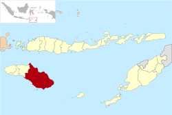 Location within East Nusa Tenggara | |
 East Sumba Regency Location in Sumba, Lesser Sunda Islands and Indonesia  East Sumba Regency East Sumba Regency (Lesser Sunda Islands)  East Sumba Regency East Sumba Regency (Indonesia) | |
| Coordinates: 9.8833°S 120.2500°E | |
| Country | |
| Region | Lesser Sunda Islands |
| Province | |
| Capital | Waingapu |
| Government | |
| • Regent | Gidion Mbilijora |
| • Vice Regent | Umbu Lili Pekuwali |
| Area | |
| • Total | 7,000.5 km2 (2,702.9 sq mi) |
| Population (2020 Census) | |
| • Total | 244,820 |
| • Density | 35/km2 (91/sq mi) |
| [1] | |
| Time zone | UTC+8 (ICST) |
| Area code | (+62) 387 |
| Website | sumbatimurkab |
Administrative Districts
The East Sumba Regency is composed of twenty-two districts (kecamatan), whose areas (in km2) and populations at the 2010 Census[4] and 2020 Census[5] are listed below. The 2020 population figures are rounded to the nearest 100 people. The table also includes the locations of the district headquarters, the number of administrative villages (rural desa and urban kelurahan) in each district, and its postal code.
| Name | Area (in km2) | Population Census 2010 | Population Census 2020 | Administrative centre | Number of villages | Post code |
|---|---|---|---|---|---|---|
| Lewa | 281.1 | 15,423 | 15,500 | Pamati Karata | 8 | 87150 |
| Nggaha Oriangu | 286.4 | 8,614 | 9,900 | Karipidita | 8 | 87155 |
| Lewa Tidahu | 322.1 | 6,129 | 6,900 | Laikeri | 6 | 87151 |
| Katala Hamu Lingu | 453.1 | 3,699 | 4,100 | Kombapari | 5 | 87152 |
| Tabandung | 514.4 | 8,301 | 9,100 | Malahar | 10 | 87160 |
| Pinupahar | 246.6 | 6,410 | 6,900 | Tawui | 6 | 87161 |
| Paberiwai | 199.7 | 5,619 | 6,300 | Kananggar | 7 | 87175 |
| Karera | 334.6 | 7,365 | 7,700 | Nggongi | 7 | 87172 |
| Matawai Lapawu | 405.4 | 5,786 | 6,100 | Tanarara | 6 | 87174 |
| Kahaungu Eti | 475.1 | 8,214 | 8,800 | Kamanggih | 9 | 87171 |
| Mahu | 196.6 | 3,922 | 4,200 | Wairara | 6 | 87170 |
| Ngadu Ngala | 207.9 | 4,787 | 5,100 | Praiwitu | 5 | 87172 |
| Pahunga Lodu | 349.8 | 12,247 | 13,100 | Ngala | 8 | 87182 |
| Wula Waijelu | 221.3 | 6,902 | 7,700 | Wula | 7 | 87183 |
| Rindi | 366.5 | 9,070 | 9,700 | Tanaraing | 8 | 87181 |
| Umalulu | 307.9 | 16,251 | 17,700 | Melolo | 10 | 87180 |
| Pandawai | 412.6 | 14,776 | 17,300 | Kawangu | 7 | 87176 |
| Kambata Mapambuhang | 412.7 | 3,434 | 3,900 | Lukuwingir | 8 | 87171 (a) |
| Kota Waingapu | 73.8 | 35,142 | 35,900 | Waingapu | 7 | 87111-87116 |
| Kambera | 52.0 | 31,137 | 33,500 | Pakukinjara | 8 | 87113-87116 |
| Haharu | 601.5 | 5,586 | 6,300 | Rambangaru | 10 | 87153 |
| Kanatang | 279.4 | 8,918 | 10,300 | Temu | 7 | 87154 |
| Totals | 7,000.5 | 227,732 | 244,820 | Waingapu | 156 |
Note: (a) except village of Lukuwingir (which has a postcode of 87116).
Airport
Umbu Mehang Kunda Airport, also formerly known as Mau Hau Airport, has a 6,070-ft (1.850 metres) long runway with 98-ft (30 metres) width and can accommodate Boeing 737-300 aircraft. The Airport inaugurated a new terminal on 2016 which is able to improve passenger services from the previous old terminal.
References
| Wikimedia Commons has media related to East Sumba Regency. |
- Badan Pusat Statistik, Jakarta, 2021.
- Biro Pusat Statistik, Jakarta, 2011.
- Badan Pusat Statistik, Jakarta, 2021.
- Biro Pusat Statistik, Jakarta, 2011.
- Badan Pusat Statistik, Jakarta, 2021.
Regencies and cities of East Nusa Tenggara | ||
|---|---|---|
Capital: Kupang | ||
| Regencies |
|  |
| Cities |
| |
See also: List of regencies and cities of Indonesia | ||
Authority control | |
|---|---|
| General | |
| National libraries | |
This East Nusa Tenggara location article is a stub. You can help Wikipedia by expanding it. |
Другой контент может иметь иную лицензию. Перед использованием материалов сайта WikiSort.org внимательно изучите правила лицензирования конкретных элементов наполнения сайта.
WikiSort.org - проект по пересортировке и дополнению контента Википедии