world.wikisort.org - Indonesia
Manggarai Regency is a regency in East Nusa Tenggara province of Indonesia, situated on the island of Flores. Established in 1958[2] the regency was reduced in size and population by the separation of Manggarai Barat regency in 2003 and of Manggarai Timur regency in 2007. The area of the residual Manggarai Regency is 2,096.44 km2 and its population was 292,037 at the 2010 census[3] and 312,855 at the 2020 census.[1] The capital of the regency is the town of Ruteng.
Manggarai Regency
Kabupaten Manggarai | |
|---|---|
Regency | |
 Coat of arms | |
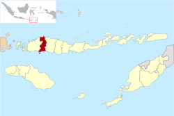 Location within East Nusa Tenggara | |
 Manggarai Regency Location in Flores, Lesser Sunda Islands and Indonesia  Manggarai Regency Manggarai Regency (Lesser Sunda Islands)  Manggarai Regency Manggarai Regency (Indonesia) | |
| Coordinates: 8.6127°S 120.4626°E | |
| Country | |
| Province | |
| Capital | Ruteng |
| Government | |
| • Regent | Deno Kamelus |
| • Vice Regent | Victor Madur |
| Area | |
| • Total | 809.44 sq mi (2,096.44 km2) |
| Population (2020 census)[1] | |
| • Total | 312,855 |
| Area code | (+62) 385 |
| Website | manggaraikab |
The Liang Bua archeological site is in Manggarai regency, about 10 km to the north of Ruteng.
Administrative districts
The Manggarai Regency as at 2010 was divided into nine districts (kecamatan), but since 2010 three additional districts – Cibal Barat, Reok Barat and more recently Satar Mese Utara – have been created by splitting of existing districts. The districts are tabulated below with their areas and their 2010 census populations[3] and the 2020 census.[1] The table also includes the locations of the district administrative centres, the number of administrative villages (rural desa and urban kelurahan) in each district, and its postal codes.
| District name | Area in km2 | Pop'n census 2010 | Pop'n census 2020 | Administrative centre | No. of villages | Post codes |
|---|---|---|---|---|---|---|
| Satar Merse | 298.80 | 30,583 | 33,917 | Iteng | 23 | 86561 |
| Satar Mese Barat (West Satar Mese) (a) | 199.93 | 30,044 | 18,944 | Narang | 12 | 86560 |
| Satar Mese Utara (North Satar Mese) | 179.00 | (b) | 14,854 | Langke Majok | 11 | 86562 |
| Langke Rembong | 60.54 | 66,364 | 65,626 | Ruteng | 20 | 86511 - 86519 |
| Ruteng | 136.26 | 38,888 | 41,533 | Cancar | 19 | 86523 |
| Wae Rii | 129.89 | 25,596 | 28,788 | Timung | 17 | 86594 |
| Lelak | 64.64 | 10,820 | 12,111 | Rejeng | 10 | 86521 |
| Rahung Utara (North Rahong) | 131.95 | 20,659 | 22,180 | Purang | 12 | 86522 |
| Cibal | 139.94 | 37,800 | 25,569 | Pagal | 17 | 86591 |
| Cibal Barat (West Cibal) | 118.95 | (c) | 15,111 | Golo Woi | 10 | 86590 |
| Reok | 236.80 | 31,697 | 19,291 | Reo | 10 | 86592 |
| Reok Barat (West Reok) | 399.74 | (d) | 14,931 | Sambi | 10 | 86593 |
| Totals | 2,096.44 | 292,451 | 312,855 | Ruteng | 171 |
Notes: (a) including the island of Pulau Mules off the south coast of Flores Island. (b) the 2010 population of Satar Mese Utara is included with the figure for Satar Mese Barat District. (c) the 2010 population of Cibal Barat is included with the figure for Cibal District. (d) the 2010 population of Reok Barat is included with the figure for Reok District.
References
- Badan Pusat Statistik, Jakarta, 2021.
- Government of Indonesia (9 August 1958), Establishment of the Second-level Administrative Regions under the First-level Administrative Region of Bali, West Nusa Tenggara and East Nusa Tenggara (in Indonesian), Indonesia Ministry of Law and Justice, UU No. 69/1958
- Biro Pusat Statistik, Jakarta, 2011.
Regencies and cities of East Nusa Tenggara | ||
|---|---|---|
Capital: Kupang | ||
| Regencies |
|  |
| Cities |
| |
See also: List of regencies and cities of Indonesia | ||
Authority control | |
|---|---|
| General | |
| National libraries | |
This East Nusa Tenggara location article is a stub. You can help Wikipedia by expanding it. |
Другой контент может иметь иную лицензию. Перед использованием материалов сайта WikiSort.org внимательно изучите правила лицензирования конкретных элементов наполнения сайта.
WikiSort.org - проект по пересортировке и дополнению контента Википедии