world.wikisort.org - Indonesia
Banjarbaru is the capital city of South Kalimantan, one of the provinces in Indonesia. It is located 35 km (22 mi) southeast of Banjarmasin, the largest city of the province. The city had a population of 248,423 as of the 2017 Census, and the latest official population estimate (as of 2019) is 262,719.[2] The town of Martapura lies immediately to the north of Banjarbaru, and in effect constitutes an extension of the city. The second largest city in the province after Banjarmasin, it is also part of Banjarbakula metropolitan area.[3]
Banjarbaru | |
|---|---|
City | |
Clockwise, from top: Dr. Murdjani Field, Al Munawarah Grand Mosque, Welcome Monument, Lambung Mangkurat Museum | |
 Coat of arms | |
| Nickname(s): Kota Bukit (City of Hills) | |
| Motto: Gawi Sabarataan | |
 Interactive map outlining Banjarbaru | |
 Location within the Province of South Kalimantan | |
 Banjarbaru Location within Kalimantan  Banjarbaru Location within Indonesia | |
| Coordinates: 03°26′33″S 114°49′57″E | |
| Country | |
| Province | |
| Government | |
| • Mayor | Aditya Mufti Ariffin |
| • Vice Mayor | Wartono |
| Area | |
| • Total | 371.38 km2 (143.39 sq mi) |
| Elevation | 23 m (75 ft) |
| Population (2019) | |
| • Total | 262,719 |
| • Density | 710/km2 (1,800/sq mi) |
| Time zone | UTC+8 (Indonesia Central Time) |
| Area code | (+62) 511 |
| HDI (2019) | |
| Website | banjarbarukota.go.id |


History
Etymology
Banjarbaru was previously only a temporary name used by governor Dr. Murdjani to differentiate it from Banjarmasin, as "baru" means "new" in Indonesian. However, the name stuck between people living there and gradually became official name of the city.[4] Banjarbaru previously consisted of a series of hills known as Mount Apam.[4]
Early history
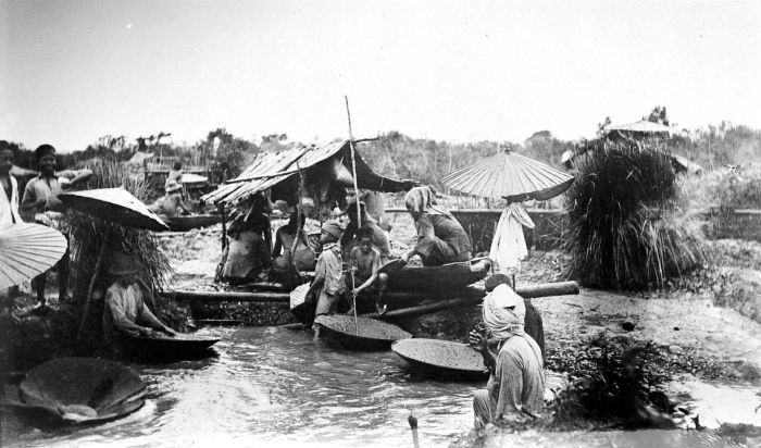
Diamond mines in Cempaka have existed since the 15th century under the Hindu-Buddhist kingdom Negara Dipa.[5] In the era of the Banjar Sultanate, there was a royal edict stating that diamonds of four carats or higher should be sold only to the sultan.[6] The place was mostly uninhabited except for resting places of diamond mine laborers from Cempaka, now also part of the city.[7] Cempaka diamond mines under the colonial era were regulated under Ordonantie 25 Nopember 1923 Staatblast 1923 No. 174 together with Pelaihari and Martapura.[8]
After independence

In the 1950s, because of frequent floods that disrupted government activities in Banjarmasin, it was suggested to relocate the capital of then-Kalimantan province to a new city. The construction and city planning was assisted by a Dutch-descendant architect named D.A.W. Van der Pijl based on the European city concept, which explains the abundance of city parks and a city hall in the center of the city.[9][10] However, the plan to relocate the provincial government was never realized fully. As of April 2021,[update] only the South Kalimantan governor's office has been relocated, while the parliament is still in Banjarmasin.[4][7][11][12]
The city was previously intended by Sukarno to be new center of the steel industry in Kalimantan with assistance from the Soviet Union to develop it.[13][14] Cooperation between the two was formalized on 11 September 1956. However, the plan to construct steel factories was never realized until after the 30 September Movement and subsequent purge of communism in Indonesia. Traces of Soviet projects can be seen in the city such as with Mess L.[15][16][17]
On 27 April 1999, Banjarbaru gained its status as a city and was recognized as part of the Banjarbakula metropolitan area.[3][18] The city was legally became capital of the South Kalimantan province on 15 February 2022 following updates of laws concerning legal basis of several provinces were passed by People's Representative Council.[19]
Geography
Banjarbaru is located at the foot of the Meratus Mountains, with 80% of the city area elevated between 0 and 25 m (82 ft) above sea level, but it also includes areas up to 500 m (1,600 ft) high. In the North, East, and West it borders Banjar Regency, while in the South it borders Tanah Laut Regency. Podzol dominates the city soil, with a concentration of as much as 63.82%. However, Landasan Ulin's soil is instead dominated by peat and alluvium.[20]
Compared to other regencies and cities in the province, Banjarbaru is also the second smallest second-level administrative division in the province after Banjarmasin city, covering around 0.88% of province territory.[21]
Climate
Banjarbaru has a tropical rainforest climate (Af according to the Köppen climate classification) with abundant rainfall in all months, although June to October is comparatively drier. Banjarbaru receives 2,627 millimetres (103.4 in) of rain annually. Temperatures are uniform in all months due to its equatorial location, with the average annual temperature being 27.2 °C (81.0 °F). On 16 August 1997, Banjarbaru recorded a temperature of 40.6 °C (105.1 °F), which is the highest temperature that has ever been recorded in Indonesia.[22][23]
| Climate data for Banjarbaru | |||||||||||||
|---|---|---|---|---|---|---|---|---|---|---|---|---|---|
| Month | Jan | Feb | Mar | Apr | May | Jun | Jul | Aug | Sep | Oct | Nov | Dec | Year |
| Average high °C (°F) | 30.3 (86.5) |
30.7 (87.3) |
31.0 (87.8) |
31.8 (89.2) |
32.0 (89.6) |
31.5 (88.7) |
31.4 (88.5) |
32.1 (89.8) |
32.5 (90.5) |
32.9 (91.2) |
31.9 (89.4) |
30.7 (87.3) |
31.6 (88.8) |
| Daily mean °C (°F) | 26.7 (80.1) |
26.9 (80.4) |
27.2 (81.0) |
27.7 (81.9) |
27.8 (82.0) |
27.0 (80.6) |
26.5 (79.7) |
26.9 (80.4) |
27.2 (81.0) |
27.8 (82.0) |
27.6 (81.7) |
26.9 (80.4) |
27.2 (80.9) |
| Average low °C (°F) | 23.2 (73.8) |
23.2 (73.8) |
23.4 (74.1) |
23.6 (74.5) |
23.6 (74.5) |
22.5 (72.5) |
21.6 (70.9) |
21.7 (71.1) |
21.9 (71.4) |
22.8 (73.0) |
23.3 (73.9) |
23.2 (73.8) |
22.8 (73.1) |
| Average rainfall mm (inches) | 360 (14.2) |
310 (12.2) |
309 (12.2) |
228 (9.0) |
192 (7.6) |
137 (5.4) |
143 (5.6) |
116 (4.6) |
101 (4.0) |
150 (5.9) |
258 (10.2) |
323 (12.7) |
2,627 (103.6) |
| Source: Climate-Data.org[24] | |||||||||||||
Demographics
Around 94% of the city population are Muslim, 4.6% are Christian, 0.21% Hindu, and 0.16% Buddhist.[2] There were 134,987 male and 127,732 female people in the city as of 2019, with a sex ratio of 100:106.[25] North Banjarbaru is the most densely populated district with 2,075 people per square kilometer and Cempaka is the least dense district with 223 people per square kilometer.[25]
The city population is dominated by young adults with an age range of 20 to 39 years old. The population within reproductive age (15 – 64 years old) make up to 70% of city's population as of 2019.[25] Life expectancy of the city is 71.87 years as of 2019, which is slightly above the national figure and significantly higher than the provincial figure.[25]
Economy

Economic growth in 2019 was 7%, which is above the national average.[26] The service sector dominated the city's economy[27] at around 23.47% in 2011.[28] Other big sectors include restaurant & hotel and construction, accounting for 18.70% and 18.33% respectively.[28] In 2013, the service sector alone employed 26,533 people from the city.[29] Other sectors such as processing (12.06%), communication (7.95%) and banking (4.01%) also exist in the city.[28] The creative economy and tourism only employed around 500 people in 2020.[28][30]
Cempaka district's economy is the only one that relies on mining (mainly diamond) and the agriculture sector.[28] The diamond mining industry is plagued by free riders.[8] According to Media Indonesia, in 2011 there were 200 miner groups, consisting of around 1,000 diamond miners in 4 urban villages (kelurahan), both with modern means of mining diamonds with water pumps or traditional methods.[8] The diamond mining industry in Cempaka occupies around 2,000 hectares of area in the district.[8] The city authority faced difficulty in collecting taxes from the mining industry because of its informal nature and the fact that most diamond transactions happened in secrecy. This, combined with the general decline of mining industry investment, made mining only account for around 8.12% of the city's gross regional product in 2011.[8][28] The agriculture sector is also shrinking and contributes little to the city's economy, with the figure 4.51% in 2011. The amount of paddy fields in the city is small, only 4,522 hectares cultivated in 2010.[31] The young and educated demographic that are not interested in the mining or agriculture sector combined with city's lack of natural resources compared to neighboring regions made both sectors shrink in size.[31][32] The unemployment rate is 5.06% as of 2019.[2]
Governance
Administrative division
Banjarbaru has an area of 371.3 km2 (143.4 sq mi), divided into five districts (kecamatan): Banjarbaru Utara (North Banjarbaru), Banjarbaru Selatan (South Banjarbaru), Cempaka, Landasan Ulin and Liang Anggang, as set out below with their 2019 Census populations:[33]
- Landasan Ulin District (67,542)
- Liang Anggang District (46,507)
- Cempaka District (36,762)
- North Banjarbaru District (56,039)
- South Banjarbaru District (55,869)
Local government

As with all of Indonesian cities, the local government is a second-level administrative division run by a mayor and vice mayor together with the city parliament, and it is equivalent to regency.[34] Executive power lies in the mayor and vice mayor, while legislation duties are carried by local parliament. Mayor, vice mayor, and parliament members are democratically elected by people of the city in an election.[35] Meanwhile, head of districts are appointed directly by city mayor with recommendation by the city secretary.[36][37]
Politics
Banjarbaru People's Representative Council Dewan Perwakilan Rakyat Banjarbaru | |
|---|---|
 Building of Banjarbaru city parliament (Banjarbaru People's Representative Council) | |
| Type | |
| Type | Unicameral |
| History | |
New session started | 9 October 2019 |
| Structure | |
| Seats | 30 |
Political groups | PKB (3)
Gerindra (6)
PDIP (3)
Golkar (5)
NasDem (4)
PPP (4)
PKS (2)
PAN (2)
Demokrat (1) |
| Elections | |
Voting system | Open list |
The city is part of the 7th electoral district for provincial parliament, together with Tanah Laut Regency, which combined have 8 out of 55 representatives.[38] At the city level, the parliament of the city has 30 representatives from four electoral districts.[38] They are 1st electoral district (consist of South Banjarbaru and North Banjarbaru) with 12 representatives, 2nd electoral district (consist of Cempaka) with 4 representatives, 3rd electoral district (consist of Liang Anggang) with 5 representatives, and 4th electoral district (consist of Landasan Ulin) with 9 representatives.[38] As of 2021,[update] the last election for parliament was on 17 April 2019 and the next one will be in the year 2024.[39]
| Electoral District | Region | Representatives |
|---|---|---|
| Banjarbaru 1st | South Banjarbaru, North Banjarbaru | 12 |
| Banjarbaru 2nd | Cempaka | 4 |
| Banjarbaru 3rd | Liang Anggang | 5 |
| Banjarbaru 4th | Landasan Ulin | 9 |
| Total | 30 | |
Culture and entertainment


There is only one mall in the city, QMall, which is located in the North Banjarbaru district, occupying 40 hectares of land.[40] It is integrated with one hotel, Grand Dafam Q Hotel, which is connected to the mall itself.[41][42] Several entertainment & amusement parks exist in the city, such as Amanah Borneo Park, Banua Labyrinth Park, Aquatica Waterpark, and QMall Waterboom.[43][44][45] The city also has a public swimming pool owned by the city government named Idaman Public Swimming Pool.[46][47] Mentaos Pine Forest, a 1,000 square kilometer city forest located in the North Banjarbaru district, is also a popular tourist destination.[48][49]
"Kampung Pelangi" (lit: rainbow village) has become a major tourist spot in the city. It is located on the edge of the Kemuning river, South Banjarbaru district. Previously a slum, it has been upgraded to showcase a waterfront, a better housing complex with parks, a pedestrian area, and WiFi corners.[50][51][52]
There is only one museum in the city, Lambung Mangkurat Museum, and it has several historical collections from the Banjar Sultanate era to the National Revolution.[53][54]
Health
There are seven hospitals in the city, 10 puskesmas, 37 clinics, 128 healthcare centers, and 18 maternity cottages.[2] The biggest public hospital, Idaman Regional Hospital, is owned by the city government.[55] Other than that, the biggest private hospital in the city is the Syifa Medika Hospital, located in the Landasan Ulin district.[56][57] There are also three laboratoriums for various purposes in the city as of 2021, one of them being a disease control laboratorium.[58][59]

Education
In Banjarbaru, there are 164 kindergartens, 83 elementary schools, 37 junior high schools, 23 senior high schools, and 16 vocational high schools (SMK) both public and private.[2] In addition, there are 14 higher education institutions; the most notable being Lambung Mangkurat University.[2] Lambung Mangkurat University is also the only public university in the city, while the rest of higher education institutions are private.[60][61][62]

Landmarks
Dr. Murdjani Field – named after a former governor of the province – is located at the center of the city across from the city hall and city park complex.[63] Previously the main wet market in the city was located close to city parks, but it was relocated in early 2021.[64] Several convenience store chains such as Alfamart and Indomaret had already established a presence in the city.[65][66] Previously, the city featured the Haji Idak Stadium, but it was demolished and the site is now used for the new wet market building.[64][67] As the replacement, a bigger new sport complex named "New Stadium of Banjarbaru" is planned to be built in the Landasan Ulin district.[68][69] Komet Windpump, originally built in 1972[70] and restored in 2021,[71] was the naming inspiration for the surrounding Komet subdistrict.[72]
Places of worship
There are around 20 churches in the city, a Balinese temple in the Landasan Ulin district, and more than 50 mosques.[73][74][75] The biggest mosque in the city is Al Munawarah Grand Mosque in South Banjarbaru. It was inaugurated by then-mayor of the city, Rudy Resnawan, on 1 July 2010.[76]
Transportation
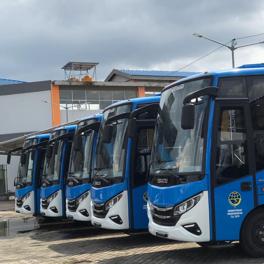
The city is served by a bus rapid transit system, BRT Banjarbakula, which also serves neighboring regencies and cities.[77] There are also angkots in the city, online motorcycle taxi services provided by Gojek and Grab, and conventional taxis.
Syamsudin Noor International Airport is located in the Landasan Ulin district.[78] Banjarbaru has more than 645 km (401 mi) of roads, of which 539 km (335 mi) are paved with asphalt.[2] The city is connected to Trans-Kalimantan Highway Southern Route, which connects it to other cities such as Banjarmasin and to the neighboring provinces, East Kalimantan and Central Kalimantan. A toll road connecting the city to Batulicin is under construction as of November 2020[update].[79]
As of 2021,[update] there is a plan for an airport rail link which is expected to start construction in December 2021, which would also be connected to Banjarmasin.[80][81][82] At the same time, the government is making plans for a new development area dubbed "Aero City", aimed to spur further development in the region.[83][84]
Media
According to the Indonesia Press Council, there are four media companies registered in Banjarbaru, consisting of two cyber media, one printed, and one television. They are KanalKalimantan, Teras7, Radar Banjarmasin, and Amaco Media.[85] However, due to lack of registration & verification, the numbers could be higher according to the Indonesian Cyber Media Union.[86] There are two known radio stations, Nirwana FM Banjarbaru and Abdi Persada FM. Nirwana FM Banjarbaru is licensed by the Ministry of Communication and Information Technology.[87][88][89]
The city government, according to Regional Regulation Number 2 Year 2010, established "Local Public Broadcaster" on television and radio, and it is supervised by local government civil servants. This, according to the law, acted as a means for the city government to communicate with city public and has non-commercial nature.[90]
See also
- List of regencies and cities of Indonesia
References
- "Pembangunan Manusia | Kota Banjar Baru". ipm.bps.go.id. Archived from the original on 25 December 2018. Retrieved 25 December 2018.
- "BPS Kota Banjarbaru". banjarbarukota.bps.go.id. Archived from the original on 19 January 2022. Retrieved 9 April 2021.
- "PU-net". perkotaan.bpiw.pu.go.id. Archived from the original on 10 May 2021. Retrieved 9 April 2021.
- "Sejarah – Humas Kota Banjarbaru". Archived from the original on 8 May 2021. Retrieved 9 April 2021.
- "KARAKTERISTIK KAWASAN PERMUKIMAN PENAMBANG INTAN CEMPAKA" (pdf). Archived from the original on 16 April 2021. Retrieved 16 April 2021.
- "EKSPLOITASI SOMBER DAYA ALAM VERSUS PERLINDUNGAN SUMBER DAYA BUDAYA Dl PEGUNUNGAN MERATUS" (pdf). Archived from the original on 16 April 2021. Retrieved 16 April 2021.
- Khairally, Elmy Tasya. "Sudah Pernah ke Banjarbaru? Ini 5 Objek Wisata Menariknya". detikTravel (in Indonesian). Archived from the original on 10 May 2021. Retrieved 9 April 2021.
- "ANALISIS SOSIOLOGI EKONOMI PADA TAMBANG RAKYAT" (pdf). Archived from the original on 28 July 2020. Retrieved 15 April 2021.
- Aufa, Naimatul; Anhar, Pakhri (18 January 2016). "Studi Tata Ruang Kota Rancangan Van Der Pijl Kasus: Kota Banjarbaru, Kalimantan Selatan". Tataloka. 14 (2): 142–155. ISSN 2356-0266. Archived from the original on 10 May 2021. Retrieved 9 April 2021.
- "Sebuah Gagasan Kota Baru di Banjarbaru, Aero City – Redaksi 8" (in Indonesian). 18 April 2019. Archived from the original on 18 May 2021. Retrieved 9 April 2021.
- "KalselPedia : Rancang Tata Kota Banjarbaru, Makam Van der Pijl berada di Taman Makam Pulau Beruang". Banjarmasin Post (in Indonesian). Archived from the original on 20 May 2021. Retrieved 9 April 2021.
- "Perkantoran Pemprov Kalsel Seperti Intan dan Juga Rasi Bintang". Banjarmasin Post (in Indonesian). Archived from the original on 9 April 2021. Retrieved 9 April 2021.
- "Mess L Banjarbaru, Kemesraan Presiden Soekarno Dan Rusia" (in Indonesian). 26 April 2020. Archived from the original on 16 April 2021. Retrieved 16 April 2021.
- "KalselPedia : Sejarah Mess L Banjarbaru". Archived from the original on 16 April 2021. Retrieved 16 April 2021.
- Studio, Aldiskatel (4 August 2019). "Jejak Uni Soviet di Mess L Banjarbaru, Bukti Proyek Besi Baja Kalimantan di Era Soekarno". Kanal Kalimantan (in Indonesian). Archived from the original on 16 April 2021. Retrieved 16 April 2021.
- "KalselPedia : Sejarah Mess L Banjarbaru, Dulu Terkesan Horor Kini Jadi Bangunan Cantik". Banjarmasin Post (in Indonesian). Archived from the original on 16 April 2021. Retrieved 16 April 2021.
- Pramono, Yudhi. "SEJARAH PROYEK BESI-BAJA KALIMANTAN 1956-1965-2012". Meratus Jaya. Archived from the original on 16 April 2021. Retrieved 16 April 2021.
- "UU No. 9 Tahun 1999 tentang Pembentukan Kotamadya Daerah Tingkat II Banjarbaru [JDIH BPK RI]". peraturan.bpk.go.id. Archived from the original on 20 April 2021. Retrieved 20 April 2021.
- Agency, ANTARA News. "Banjarbaru resmi ibukota Provinsi Kalimantan Selatan". ANTARA News Kalimantan Selatan. Retrieved 19 February 2022.
- "Profil Kota Banjarbaru 2014" (PDF). Archived (PDF) from the original on 15 April 2021. Retrieved 15 April 2021.
- "Geografis – Humas Kota Banjarbaru". Archived from the original on 8 May 2021. Retrieved 9 April 2021.
- "Historis Kejadian Iklim Ekstrim" (in Indonesian). Meteorology, Climatology, and Geophysical Agency of Indonesia (BMKG). 2011. Retrieved 2 May 2021.
- Putri, Gloria Setyvani (24 October 2019). "Cuaca Panas Masih 9 Hari, Ini Daftar Hari Terpanas di Indonesia" (in Indonesian). Kompas. Retrieved 2 May 2021.
- "Climate: Banjarbaru". Climate-Data.org. Archived from the original on 19 January 2022. Retrieved 24 November 2020.
- "BPS Kota Banjarbaru". banjarbarukota.bps.go.id. Archived from the original on 18 April 2021. Retrieved 18 April 2021.
- "Pertumbuhan Ekonomi Kota Banjarbaru 7%, di Atas Rata-rata Nasional". SINDOnews.com (in Indonesian). 28 February 2019. Archived from the original on 19 January 2022. Retrieved 9 April 2021.
- Agency, ANTARA News. "LAPSUS – Banjarbaru Kembangkan Sektor Jasa Perkuat Perekonomian". ANTARA News Kalimantan Selatan. Archived from the original on 15 April 2021. Retrieved 15 April 2021.
- "PROFIL KOTA BANJARBARU" (PDF). Archived (PDF) from the original on 15 April 2021. Retrieved 15 April 2021.
- "Jumlah Pekerja di Sektor Jasa Sosial di Kota Banjarbaru, Kalimantan Selatan 2007 – 2013 | Databoks". databoks.katadata.co.id (in Indonesian). Archived from the original on 19 January 2022. Retrieved 15 April 2021.
- "Infografis – Kota Banjarbaru" (PDF). Archived (PDF) from the original on 15 April 2021. Retrieved 15 April 2021.
- "ANALISIS POTENSI PEREKONOMIAN KOTA BANJARBARU". Archived from the original on 15 April 2021. Retrieved 15 April 2021.
- Agency, ANTARA News. "Banjarbaru Harus Tingkatkan Sektor Jasa". ANTARA News Kalimantan Selatan. Archived from the original on 15 April 2021. Retrieved 15 April 2021.
- Biro Pusat Statistik, Jakarta, 2011.
- "UU 22 1999" (PDF). Archived (PDF) from the original on 16 April 2021. Retrieved 16 April 2021.
- "UU 8 2015" (PDF). Archived (PDF) from the original on 26 February 2021. Retrieved 16 April 2021.
- "PP No. 17 Tahun 2018 tentang Kecamatan [JDIH BPK RI]". peraturan.bpk.go.id. Archived from the original on 17 April 2021. Retrieved 16 April 2021.
- Government Law No.19 1998
- "Keputusan KPU Kalsel Nomor 265 2018" (PDF). Archived (PDF) from the original on 10 December 2018. Retrieved 16 April 2021.
- "Fraksi-fraksi | DPRD Banjarbaru". Archived from the original on 16 April 2021. Retrieved 16 April 2021.
- "Pemilik Mall Banjarbaru dulu Ingin Jadi Guru". Archived from the original on 19 January 2022. Retrieved 19 January 2022.
- "Profile Q Mall Banjarbaru". InfoPromoDiskon.com. Archived from the original on 16 April 2021. Retrieved 16 April 2021.
- "Grand Dafam Q Hotel Banjarbaru – DHM | Hotel Management". www.dafamhotels.com. Archived from the original on 16 April 2021. Retrieved 16 April 2021.
- "Amanah Borneo Park, Destinasi Wisata Edukasi Kekinian di Banjarbaru – Borneo ID". 26 June 2020. Archived from the original on 16 April 2021. Retrieved 16 April 2021.
- "Kebun Raya Banua – Pemerintah Provinsi Kalimantan Selatan". kebunrayabanua.kalselprov.go.id. Archived from the original on 16 April 2021. Retrieved 16 April 2021.
- "KalselPedia – Puas Main Air di Banjarbaru, Ini Lima Lokasi Kolam Renang Paling Hits Kota Idaman". Banjarmasin Post (in Indonesian). Archived from the original on 16 April 2021. Retrieved 16 April 2021.
- "KalselPedia – Kolam Renang di Kota Banjarbaru". Banjarmasin Post (in Indonesian). Archived from the original on 16 April 2021. Retrieved 16 April 2021.
- Bahid, Mustaqiem (16 February 2019). "Kolam Renang Idaman Banjarbaru Kini Jadi Objek Wisata Air Pilihan" (in Indonesian). Archived from the original on 16 April 2021. Retrieved 16 April 2021.
- "Wisata Hutan Pinus Mentaos Banjarbaru, Banyak Spot Foto Unik dan Menarik". Banjarmasin Post (in Indonesian). Archived from the original on 16 April 2021. Retrieved 16 April 2021.
- "Hutan Pinus Mentaos Banjarbaru Kini Jadi Destinasi Wisata Kekinian". Banjarmasin Post (in Indonesian). Archived from the original on 16 April 2021. Retrieved 16 April 2021.
- "KAMPUNG PELANGI – Kecamatan Banjarbaru Selatan" (in Indonesian). Archived from the original on 16 April 2021. Retrieved 16 April 2021.
- "Wisata Kampung Pelangi Banjarbaru Banyak Fasilitas yang Bikin Betah". Banjarmasin Post (in Indonesian). Archived from the original on 16 April 2021. Retrieved 16 April 2021.
- bisniswisata. "Peluang dan Potensi Kampung Pelangi Sebagai Magnet Wisata di Banjarbaru | Portal Berita Bisnis Wisata" (in Indonesian). Archived from the original on 16 April 2021. Retrieved 16 April 2021.
- "Belajar Sejarah ke Museum Lambung Mangkurat Banjarbaru – Borneo ID". 16 May 2020. Archived from the original on 16 April 2021. Retrieved 16 April 2021.
- "Museum Lambung Mangkurat – Humas Kota Banjarbaru". Archived from the original on 16 April 2021. Retrieved 16 April 2021.
- "RSD Idaman Kota Banjarbaru – Kesehatan Anda, Prioritas Kami". Archived from the original on 17 April 2021. Retrieved 9 April 2021.
- "RSU Syifa Medika – Sukseskan Indonesia Sehat" (in Indonesian). Archived from the original on 16 April 2021. Retrieved 16 April 2021.
- "KalselPedia – Inilah Rumah Sakit di Kota Banjarbaru". Banjarmasin Post (in Indonesian). Archived from the original on 16 April 2021. Retrieved 16 April 2021.
- "DAFTAR LABORATORIUM LINGKUNGAN TEREGISTRASI – Pusat Standardisasi Lingkungan dan Kehutanan". Archived from the original on 20 April 2021. Retrieved 20 April 2021.
- "00065/LPJ/LABLING-1/LRK/KLHK" (PDF). Archived (PDF) from the original on 20 April 2021. Retrieved 20 April 2021.
- "√ Universitas Terbaik di Kalimantan Selatan 2020/2021". Kampusimpian.com – Platform Pendidikan Indonesia (in Indonesian). 5 August 2020. Archived from the original on 16 April 2021. Retrieved 16 April 2021.
- "6+ Kampus Terbaik di Kota Banjarbaru". Fakta Kampus. Archived from the original on 16 April 2021. Retrieved 16 April 2021.
- "Universitas Lambung Mangkurat". campus.quipper.com. Archived from the original on 16 April 2021. Retrieved 16 April 2021.
- "Lapangan Murjani – Humas Kota Banjarbaru". Archived from the original on 23 December 2017. Retrieved 9 April 2021.
- "Relokasi Pasar Bauntung, 80 Persen Lebih Pedagang Memilih Pindah". Banjarmasin Post (in Indonesian). Archived from the original on 18 April 2021. Retrieved 9 April 2021.
- "Puluhan Alfamart di Banjarbaru Belum Bayar Pajak Ratusan Juta, Dinas BP2RD Akan Lakukan Ini". Banjarmasin Post (in Indonesian). Archived from the original on 11 June 2020. Retrieved 9 April 2021.
- Official, Indomaret. "Posyandu Bersama Indomaret di Banjarbaru". indomaret.co.id. Archived from the original on 2 December 2020. Retrieved 9 April 2021.
- Fitriannoor, Muhammad Ari (5 April 2021). "Banjarbaru Segera Miliki Stadion Baru Pengganti Haji Idak". KoranBanjar.Net (in Indonesian). Archived from the original on 5 April 2021. Retrieved 10 April 2021.
- Studio, Aldiskatel (8 April 2021). "MEGAH. Begini Desain The New Stadium of Banjarbaru, Ini Lokasinya". Kanal Kalimantan (in Indonesian). Archived from the original on 9 April 2021. Retrieved 9 April 2021.
- "Banjarbaru Bakal Punya Stadion Megah, Begini Bocoran Desainnya". suara.com (in Indonesian). 8 April 2021. Archived from the original on 8 April 2021. Retrieved 9 April 2021.
- "Dibiayai Rp 198 Juta, Revitalisasi Kincir Angin Komet Demi Mengembalikan Ikon Kota Banjarbaru". jejakrekam.com (in Indonesian). 27 December 2021. Archived from the original on 31 December 2021. Retrieved 31 December 2021.
- "Sarat Nilai Sejarah, Wali Kota Aditya Resmikan Restorasi Kincir Angin Comet". PGRI Kota Banjarbaru (in Indonesian). 25 December 2021. Archived from the original on 31 December 2021. Retrieved 31 December 2021.
- Studio, Aldiskatel (7 December 2021). "Kincir Angin Komet Tinggal Pasang Bilah Kipasnya". Kanal Kalimantan (in Indonesian). Archived from the original on 31 December 2021. Retrieved 31 December 2021.
- "DAFTAR RUMAH IBADAH HINDU PROVINSI KALIMANTAN SELATAN" (PDF). Archived (PDF) from the original on 9 April 2021. Retrieved 9 April 2021.
- "Daftar Masjid / Musholla di Kota Banjarbaru, Kalimantan Selatan | Profil Masjid / Musholla". Dream.co.id. Archived from the original on 19 January 2022. Retrieved 9 April 2021.
- "Data Kemenag Kalsel" (PDF). Archived (PDF) from the original on 22 April 2021. Retrieved 22 April 2021.
- "KalselPedia: Masjid Agung Al Munawwarah di Kota Banjarbaru". Banjarmasin Post (in Indonesian). Archived from the original on 16 April 2021. Retrieved 16 April 2021.
- "BRT Banjarbakula". BPTD XV KALSEL. 19 January 2021. Archived from the original on 18 April 2021. Retrieved 9 April 2021.
- "Syamsudinnoor International Airport | Banjarmasin". syamsudinnoor-airport.co.id. Archived from the original on 19 April 2021. Retrieved 9 April 2021.
- Agency, ANTARA News. "Jalan Tol Tanah Bumbu-Banjarbaru segera dioprasikan". ANTARA News Kalimantan Selatan. Archived from the original on 19 January 2022. Retrieved 9 April 2021.
- prokal.co. "Ayo Bangun Kereta Api Bandara | Radar Banjarmasin". kalsel.prokal.co (in Indonesian). Archived from the original on 9 April 2021. Retrieved 9 April 2021.
- Hidayat, Rizky (4 November 2020). "2021, Pembangunan Rel Kereta Api Bandara Mulai Dikaji" (in Indonesian). Retrieved 9 April 2021.
- Leon, Abdurahman (5 November 2020). "Pemerintah Kalsel Bangun Jalur Kereta Menuju Bandara Syamsuddin Noor". KoranBanjar.Net (in Indonesian). Archived from the original on 19 January 2022. Retrieved 9 April 2021.
- Studio, Aldiskatel (22 January 2019). "Aero City Akan Ubah Banjarbaru jadi Metropolis Masa Depan Kalsel". Kanal Kalimantan (in Indonesian). Archived from the original on 19 January 2022. Retrieved 9 April 2021.
- "DPRD Banjarbaru Harapkan Aerocity Memberikan Dampak Ekonomi di Kawasan Bandara". Banjarmasin Post (in Indonesian). Archived from the original on 24 August 2020. Retrieved 9 April 2021.
- "Dewan Pers". dewanpers.or.id. Archived from the original on 19 April 2021. Retrieved 20 April 2021.
- Studio, Aldiskatel (3 August 2019). "Masih Banyak Media Online di Kalsel Belum Terverifikasi". Kanal Kalimantan (in Indonesian). Archived from the original on 20 April 2021. Retrieved 20 April 2021.
- "Daftar Izin Radio Yang Diterima 2017" (PDF). Archived (PDF) from the original on 20 April 2021. Retrieved 20 April 2021.
- "ANALISIS PRODUK DAN PROMOSI DALAM MENINGKATKAN MINAT PENDENGAR PADA RADIO ABDI PERSADA 104,7 FM BANJARBARU" (PDF). Archived (PDF) from the original on 20 April 2021. Retrieved 20 April 2021.
- Hairiyadi (15 April 2021). "Banjarbaru Juara Dialog Interaktif Program Kerja". KoranBanjar.Net (in Indonesian). Archived from the original on 19 January 2022. Retrieved 20 April 2021.
- "Perda No 02 Tahun 2010" (PDF). Archived (PDF) from the original on 19 January 2022. Retrieved 20 April 2021.
External links
Regencies and cities of South Kalimantan | ||
|---|---|---|
Capital: Banjarmasin | ||
| Regencies | ||
| Cities |
| |
Provincial capitals in Indonesia | ||
|---|---|---|
| Sumatra |
|  |
| Java |
| |
| Kalimantan |
| |
| Lesser Sunda |
| |
| Sulawesi | ||
| Maluku |
| |
| Papua |
| |
| Former provincial capitals |
| |
На других языках
[de] Banjarbaru
Banjarbaru ist eine indonesische Stadt (Kota) in der Provinz Kalimantan Selatan, im Süden der Insel Borneo. Die Stadt mit ihren circa 250.000 Einwohnern (Stand 2021) liegt 35 km südöstlich von der Provinzhauptstadt Banjarmasin und 420 km südwestlich von Samarinda, der größten Stadt auf dem indonesischen Teil Borneos. Banjar erlangte 1966 Stadtstatus[1] und 1999 seinen eigenen Status als kreisfreie Stadt (Kota). Die Stadt ist Teil der circa zwei Millionen großen Metropolregion Banjarbakula, die aus den Städten Banjarmasin und Banjarbaru sowie aus Teilen der Regierungsbezirke Banjar, Barito Kuala und Tanah Laut besteht.- [en] Banjarbaru
[ru] Банджарбару
Банджарбару (индон. Banjarbaru) — город в Индонезии, административный центр провинции Южный Калимантан (с февраля 2022 года). Территория города выделена в самостоятельную административную единицу — муниципалитет. Второй по численности населения город провинции[2].Другой контент может иметь иную лицензию. Перед использованием материалов сайта WikiSort.org внимательно изучите правила лицензирования конкретных элементов наполнения сайта.
WikiSort.org - проект по пересортировке и дополнению контента Википедии