world.wikisort.org - India
Sri Ganganagar district is the northernmost district of Rajasthan state in western India.
This article has multiple issues. Please help improve it or discuss these issues on the talk page. (Learn how and when to remove these template messages)
|
Sri Ganganagar district | |
|---|---|
District of Rajasthan | |
 View of canal in Rawla Mandi | |
 Location of Sri Ganganagar district in Rajasthan | |
| Coordinates (Sri Ganganagar): 29°55′04″N 73°52′54″E | |
| Country | |
| State | Rajasthan |
| Division | Bikaner |
| Headquarters | Sri Ganganagar |
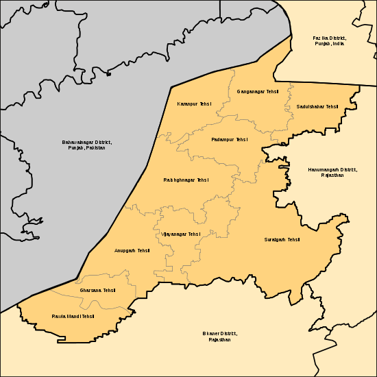
| Tehsils | Sri Ganganagar Sri Karanpur Sadulshahar Padampur Raisinghnagar Suratgarh Anoopgarh Shri Vijaynagar Gharsana Rawla Mandi |
| Government | |
| • District Magistrate | Rukmani Riar Sihag[1][2] |
| Area | |
| • Total | 11,154 km2 (4,307 sq mi) |
| Population (2011)[3] | |
| • Total | 1,969,168 |
| • Density | 180/km2 (460/sq mi) |
| Demographics | |
| • Literacy | 69.6 |
| • Sex ratio | 887 |
| Time zone | UTC+05:30 (IST) |
| Major highways | NH 62 (Old 15) |
| Website | sriganganagar |
History
Named after Maharaja Ganga Singh of Bikaner, Sri Ganganagar district was part of Bikaner state. This was a mostly uninhabited region. The history of this district is testimony to the vision and efforts of Maharaja Ganga Singh, who visualised and built the Ganga Canal after the Indian famine of 1899–1900. The waters of the Sutlej River were brought into the region through the 89-mile long Gang Canal in 1927, turning this region into a "Food Basket"[4] of Rajasthan.
Geography
Location and area
Sri Ganganagar district is located between Latitude 28.4 to 30.6 and Longitude 72.2 to 75.3[5] The total area of Sri Ganganagar is 11,154.66 km2 or 1,115,466 hectares. It is surrounded on the east by Hanumangarh district, (Hanumangarh district was carved out of it on 12 July 1994) on the south by Bikaner district, and on the west by Bahawalnagar district of Pakistani Punjab and on the north by Fazilika district of Indian Punjab.
Tehsils and other towns
Ganganagar tehsils
There are following Ten tehsils in Ganganagar district.
- Sri Ganganagar
- Sri Karanpur, headquarters in the town of Karanpur
- Sadulshahar
- Padampur
- Raisinghnagar
- Suratgarh
- Anoopgarh
- Shri Vijaynagar
- Gharsana
- Rawla Mandi
There are total 344 Gram Panchayats in Sri Ganganagar district. Ganganagar has a total of 3061 big and small villages which are the highest in Rajasthan
Other major towns and villages
Raisinghnagar, Kesrisinghpur, Gajsinghpur, Suratgarh, Ramsinghpur (59GB), Jaitsar (1GB-A), Rawla Mandi (8PSD-B) are major towns, whereas Raghunathpura (4RM), 22GB, Lalgarh Jatan (8LLG), Ridmalsar (60LNP), Kikarwali (60RB), Buddha Johad (Dabla 5NP), Binjhbayla, Rajiasar, Patroda (11P), Sameja Kothi (17PTD), Salempura, Chunawadh (30GG), Birmana (3BMM), Hindumalkot, Zorawar singhpura, Banda colony, Bajuwala, Dhaban Jhallar (15LKS), Khat Sajwar, Mirjawala (12F), Daulatpura, Netewala (2HH-1), Ganeshgarh, Mahiyawali (4HH), Dungersinghpura, Manniwali (36PTP), Narsinghpura (49LLW), Manjhuwas (52LNP), Sardargarh (11Sgm), Sanghar (10SGR), Nirbana (3NRD), Manewala (2MNWM), Sadhuwali (1D), Sri Gurusar Modia (26 MOD), Peepasar, Naharanwali (11-12Nd), Kumpali, Gudli, Rawla Gaon (10KD), Gomawali, Khanuwali (17KND), Dhaba, Bhatiwala, Kararwala, Kararwali (8NP), Hakmabad, Banwali, Matili Rathan, Dulatpur Kairi, Kotha, Pakki, Koni, Khakhan, Fatuhi, Mohanpura, Rohidawali, Gulabewala (25F), Arayan, Lakhahakam (84RB), Khatan, Rojhdi (2MGM), Satrana (9MD), 365 Head (2KLD), Old Gharsana (2Mld-A), New Gharsana (24AS-C+3STR) are small towns and villages.
There are 9 Panchayat Samitis and Blocks in SGNR are
- Suratgarh - 49 Gram Panchayat
- Raisinghnagar - 47 Gram Panchayat
- Anupgarh - 32 Gram Panchayat
- Vijaynagar - 29 Gram Panchayat
- Gharsana - 36 Gram Panchayat
- Padampur - 36 Gram Panchayat
- Karanpur - 35 Gram Panchayat
- Sadulshahar - 27 Gram Panchayat
- Ganganagar - 53 Gram Panchayat
In Ganganagar District There are also 12 Sub tehsils- Hindumalkot, Lalgarh, Chunawadh, Kesrisinghpur, Gajsinghpur, Sameja, Muklawa, Binjhbayala, Jaitsar, Rajiasar, Ramsinghpur and 365 Head.
In Ganganagar District There are 1 Municipal council is in Ganganagar and 10 Municipalities are in Suratgarh, Anupgarh, Sadulshahar, Vijaynagar, Padampur, Karanpur, Gajsinghpur, Kesrisinghpur, Lalgarh Jatan and Raisinghnagar.
There are 15 Krishi Upaj Mandi Samiti in Whole Ganganagar district. These are Ganganagar Anaj Mandi, Ganganagar Fruits & Vegetables Mandi, Sadulshahar Mandi, Karanpur Mandi, Suratgarh Mandi, Raisinghnagar Mandi, Padampur Mandi, Vijaynagar Mandi, Anupgarh Mandi, Gharsana Mandi, Rawla Mandi, Gajsinghpur Mandi, Kesrisinghpur Mandi, Jaitsar Mandi and Ridmalsar Mandi..
Many towns and cities in Sri Ganganagar district are named after members of the royal family of the former Bikaner State.
Famous Places
- Shivpur Head - Shivpur Fatuhi
- Gurudwara Budhdha Johar - Dabla
- Bishnoi Mandir & Amrita Devi Park - Dabla
- Laila Majhnu Majar - Binjor
- Airforce Suratgarh
- Thermal Power Plant Super Critical Suratgarh
- All India Radio Station Suratgarh
- Cetral Farm Suratgarh, Jaitsar, Sardargarh
- CCBF Suratgarh
- Shree Cement Udaipur Suratgarh
- Koni Village Border
- Hindumalkot Border
- Mawadiya Dhiraniya bayala Temple Binjhbayala
- Padpata Dhaam Dhaban Jhallar
- Chanana Dham - 4NN Chanana
- Hathiyawala Dham
- Anupgarh Fort
- Suratgarh Sodhal Fort
- Dhab Suratgarh
Demographics
| Year | Pop. | ±% p.a. |
|---|---|---|
| 1901 | 84,281 | — |
| 1911 | 121,077 | +3.69% |
| 1921 | 100,233 | −1.87% |
| 1931 | 202,964 | +7.31% |
| 1941 | 313,741 | +4.45% |
| 1951 | 370,238 | +1.67% |
| 1961 | 604,901 | +5.03% |
| 1971 | 732,152 | +1.93% |
| 1981 | 1,084,161 | +4.00% |
| 1991 | 1,402,444 | +2.61% |
| 2001 | 1,789,423 | +2.47% |
| 2011 | 1,969,168 | +0.96% |
| source:[6] | ||
According to the 2011 census Sri Ganganagar district has a population of 1,969,168,[7] roughly equal to the nation of Slovenia[8] or the US state of New Mexico.[9] This gives it a ranking of 235th in India (out of a total of 640).[7] The district has a population density of 179 inhabitants per square kilometre (460/sq mi) .[7] Its population growth rate over the decade 2001-2011 was 10.06%.[7] Ganganagar has a sex ratio of 887 females for every 1000 males,[7] and a literacy rate of 70.25%. Scheduled Castes and Scheduled Tribes made up 36.58% and 0.68% of the population respectively.[7]
Religion
According to the 2011 Indian census, Hinduism is the dominant religion of the district, followed by a large Sikh population and substantial followers of Islam.[10]
Languages
Hindi is the official language. The majority of the population speaks Punjabi, Rajasthani, Bagri, Standard Hindi, Baori, and Marwari.[11]
Media
The district has editions of state level newspapers from Jaipur, which are re-published from Ganganagar and Raisinghnagar.
"Air Suratgarh", a radio station, broadcasts programmes in Hindi, Rajasthani and Punjabi languages. It was commissioned in 1981 and broadcasts on the 918 kHz frequency.[12]
References
- "Punjab's Rukmani new collector of Sriganganagar". Tribune. 19 January 2022. Retrieved 9 July 2022.
- "जिला प्रशासन (DATA)". Sri Ganganagar - Govt. of Rajasthan - India (in Hindi). Retrieved 15 July 2022.
- "Name Census 2011, Rajasthan data" (PDF). censusindia.gov.in. 2012. Retrieved 28 February 2012.
- Garg, Balwant (27 July 2003). "Suicide woes fill the 'food basket'". The Times Of India.
- "Ganganagar.nic.in". Archived from the original on 19 January 2012. Retrieved 4 April 2009.
- Decadal Variation In Population Since 1901
- "District Census 2011". Census2011.co.in. 2011. Retrieved 30 September 2011.
- US Directorate of Intelligence. "Country Comparison:Population". Archived from the original on 13 June 2007. Retrieved 1 October 2011.
Slovenia 2,000,092 July 2011 est.
- "2010 Resident Population Data". U. S. Census Bureau. Retrieved 30 September 2011.
New Mexico - 2,059,179
- "C-01: Population by religious community - Sri Ganganagar district". censusindia.gov.in. Retrieved 15 June 2022.
- "C-16: Population by mother tongue - Rajasthan \website=censusindia.gov.in". Archived from the original on 15 August 2018. Retrieved 26 June 2022.
- "Air Suratgarh". All India Radio.
External links
Places adjacent to Sri Ganganagar district | ||||||||||||||||
|---|---|---|---|---|---|---|---|---|---|---|---|---|---|---|---|---|
| ||||||||||||||||
Capital: Jaipur | |||||||||||||||
| Outline |
|  | |||||||||||||
| Governance |
| ||||||||||||||
| Divisions and districts |
| ||||||||||||||
| Major cities | |||||||||||||||
| Related templates |
| ||||||||||||||
Authority control | |
|---|---|
| General |
|
| National libraries | |
На других языках
[de] Sri Ganganagar (Distrikt)
Der Distrikt Sri Ganganagar (Hindi ज़िला श्रीगंगानगर) ist ein Distrikt im westindischen Bundesstaat Rajasthan.- [en] Sri Ganganagar district
[ru] Ганганагар (округ)
Ганганагар (англ. Sri Ganganagar) — округ в индийском штате Раджастхан. Расположен на севере штата в пустыне Тар. Образован в 30 марта 1949 года. Разделён на 6 подокругов. Административный центр округа — город Ганганагар. Согласно всеиндийской переписи 2001 года население округа составляло 1 788 487 человек. Уровень грамотности взрослого населения составлял 64,84 %, что немного выше среднеиндийского уровня (59,5 %).Другой контент может иметь иную лицензию. Перед использованием материалов сайта WikiSort.org внимательно изучите правила лицензирования конкретных элементов наполнения сайта.
WikiSort.org - проект по пересортировке и дополнению контента Википедии