world.wikisort.org - India
Pali district is a district in Rajasthan, India. The city of Pali is its administrative headquarters.
Pali district | |
|---|---|
District of Rajasthan | |
     Clockwise from top-left: Dera Khairwa Fort, Kundeshwar Mahadev Temple, Velar Lake, Ranakpur Jain temple, Lake near Jawai Bera | |
 Pali district in Rajasthan, India | |
| Country | |
| State | Rajasthan |
| Headquarters | Pali |
| Division | Jodhpur division |
| Area | |
| • Total | 12,387 km2 (4,783 sq mi) |
| Population (2011)[1] | |
| • Total | 2,037,573 |
| • Density | 160/km2 (430/sq mi) |
| Languages | |
| • Official | Hindi, Rajasthani |
| Time zone | UTC+5:30 (IST) |
| PIN | 306401 |
| Telephone code | 02932 |
| ISO 3166 code | RJ-IN |
| Vehicle registration | RJ-22 |
| Literacy | 63.23% |
| Lok Sabha constituency | Pali (Lok Sabha Constituency) |
| Avg. annual temperature | 22.5 °C (72.5 °F) |
| Avg. summer temperature | 45 °C (113 °F) |
| Avg. winter temperature | 00 °C (32 °F) |
| Website | pali |
History
| Year | Pop. | ±% p.a. |
|---|---|---|
| 1901 | 393,837 | — |
| 1911 | 456,627 | +1.49% |
| 1921 | 403,318 | −1.23% |
| 1931 | 473,063 | +1.61% |
| 1941 | 555,586 | +1.62% |
| 1951 | 660,856 | +1.75% |
| 1961 | 805,682 | +2.00% |
| 1971 | 970,002 | +1.87% |
| 1981 | 1,274,504 | +2.77% |
| 1991 | 1,486,432 | +1.55% |
| 2001 | 1,820,251 | +2.05% |
| 2011 | 2,037,573 | +1.13% |
| source:[2] | ||
This section does not cite any sources. (January 2022) |
In 120 AD, during the Kushana Age, King Kanishka conquered the Rohat and Jaitaran areas, parts of today's Pali district. Until the end of the seventh century, the Chalukya king Harshavardhana ruled the area, along with other parts of what would be Rajasthan.
From the 10th to the 15th century, the boundaries of Pali extended to Mewar, Gorwar, and Marwar. Nadol was the capital of the Chauhan clan. All Rajput rulers resisted foreign invaders, but individually fought each other for land and leadership. After the defeat of Prithviraj Chauhan by Muhammad Ghori, the Rajput power in the area was removed. The Godwad area became subject to the then-ruler of Mewar, Maharana Kumbha; however, Pali, which was ruled by Rajputs with the patronage of neighbouring Rajput rulers, remained peaceful and progressive.
There were a number of battles in the surrounding areas of Pali in the 16th and 17th centuries. Shershah Suri was defeated by Rajput rulers in the Battle of Sammel near Jaitaran, and the Mughal emperor, Akbar, constantly battled with Maharana Pratap in the Gorwar area. After the Mughals had conquered almost all of Rajputana, Veer Durgadas Rathore of Marwar made organised efforts to take back Marwar from Aurangzeb, the last Mughal emperor. By then, Pali had become subservient to the Rathores of Marwar, and was reclaimed by Maharaja Vijay Singh before becoming a commercial centre.
During the British era in 1857, various Thakurs of Pali under the stewardship of the Thakur of Auwa fought against British rule. The British army surrounded Auwa Fort and the conflict lasted several days.
Geologists trace the settlement at Pali back to prehistory and maintain that Pali emerged from the vast western sea, which was spread over a large part of present-day Rajasthan. In the Vedic period, Maharshi Javali stayed in the area to meditate and interpret the Vedas. In the Mahabharata age,[clarification needed] the Pandavas made this area (near Bali) their resting place during exile. As a part of ancient Arbuda Province, the area was known as Balla-Desh.
Geography
The Aravalli Range forms the eastern boundary of the district, and the southern boundary ends at Bamnera village in Sumerpur Tehsil. There are foothills to the west, through which run some Luni River tributaries. The western portion of the district includes the alluvial plain of the Luni. The district is bounded by eight others: Nagaur District to the north, Ajmer District to the northeast, Rajsamand District to the east, Udaipur District to the southeast, Sirohi District to the southwest, Jalore District and Barmer District to the west, and Jodhpur District to the northwest. The major part of the district has ranges from 200 to 300 m above mean sea level in elevation, but in the east—toward the Aravalli Range—the elevation increases and the average is closer to 600 m, with some regions exceeding 1000 m.[3]
National geological monument
The Pali Barr Conglomerate has been declared a National Geological Monument of India by the Geological Survey of India for their protection, maintenance, promotion and enhancement of geotourism.[4][5][6]
Politics
Lok Sabha
The Pali Lok Sabha constituency has jurisdiction over two districts: Pali and Jodhpur. The current member of parliament is P P Choudhary, who represents the Bharatiya Janata Party (BJP).[7]
Legislative assembly (Vidhan Sabha)
The district is represented in the State Legislature by six MLAs (Sojat, Jaitaran, Sumerpur, Bali, Pali and Marwar Junction) and one Member of Parliament.</ref>[8]
| Constituency | MLA | Party | |
|---|---|---|---|
| Sojat | Shobha Chauhan | BJP | |
| Jaitaran | Avinash Gehlot | ||
| Bali | Pushpendra Singh Ranawat | ||
| Sumerpur | Joraram Kumawat | ||
| Pali | Gyanchand Parakh | ||
| Marwar Junction | Khushveer Singh | Independent | |
Administrative Structure
| Sub-Division | Tehsil | Panchayat Samiti |
|---|---|---|
| Bali | Bali | Bali |
| Desuri | Desuri | Desuri |
| Raipur | Raipur | Raipur |
| Rohat | Rohat | Rohat |
| Rani | Rani | Rani |
| Pali | Pali | Pali |
| Jaitaran | Jaitaran | Jaitaran |
| Marwar Junction | Marwar Junction | Marwar Junction |
| Sojat | Sojat | Sojat |
| Sumerpur | Sumerpur | Sumerpur |
Sub-divisions
Pali District has ten sub-divisions: Sojat, Marwar Junction, Jaitaran, Raipur, Sumerpur, Bali, Pali, Rohat, Rani and Desuri.
Panchyat Samiti
The Pali district has ten panchayat samiti: five are reserved for Scheduled Castes and Scheduled Tribes and Other Backward Class, and the other five are general.[9]
Tehsils
There are 10 Tehsils in the district: Sojat, Marwar Junction, Jaitaran, Raipur, Sumerpur, Bali, Pali, Rohat and Desuri. Rani has been declared to become the tenth Tehsil.[10] Marwar Junction Tehsil has highest number of villages (142), Sumerpur Tehsil has lowest number of villages (42).
Civic bodies
There are eight municipalities (Nagar Palika) in the district: Sojat, Jaitaran, Sumerpur, Sadri, Bali, Falna, Takhatgarh and Rani, Rajasthan; Pali is a Municipal Council (Nagar Parishad).
There are 1,030 villages under 320 gram panchayats in the Pali district.[11]
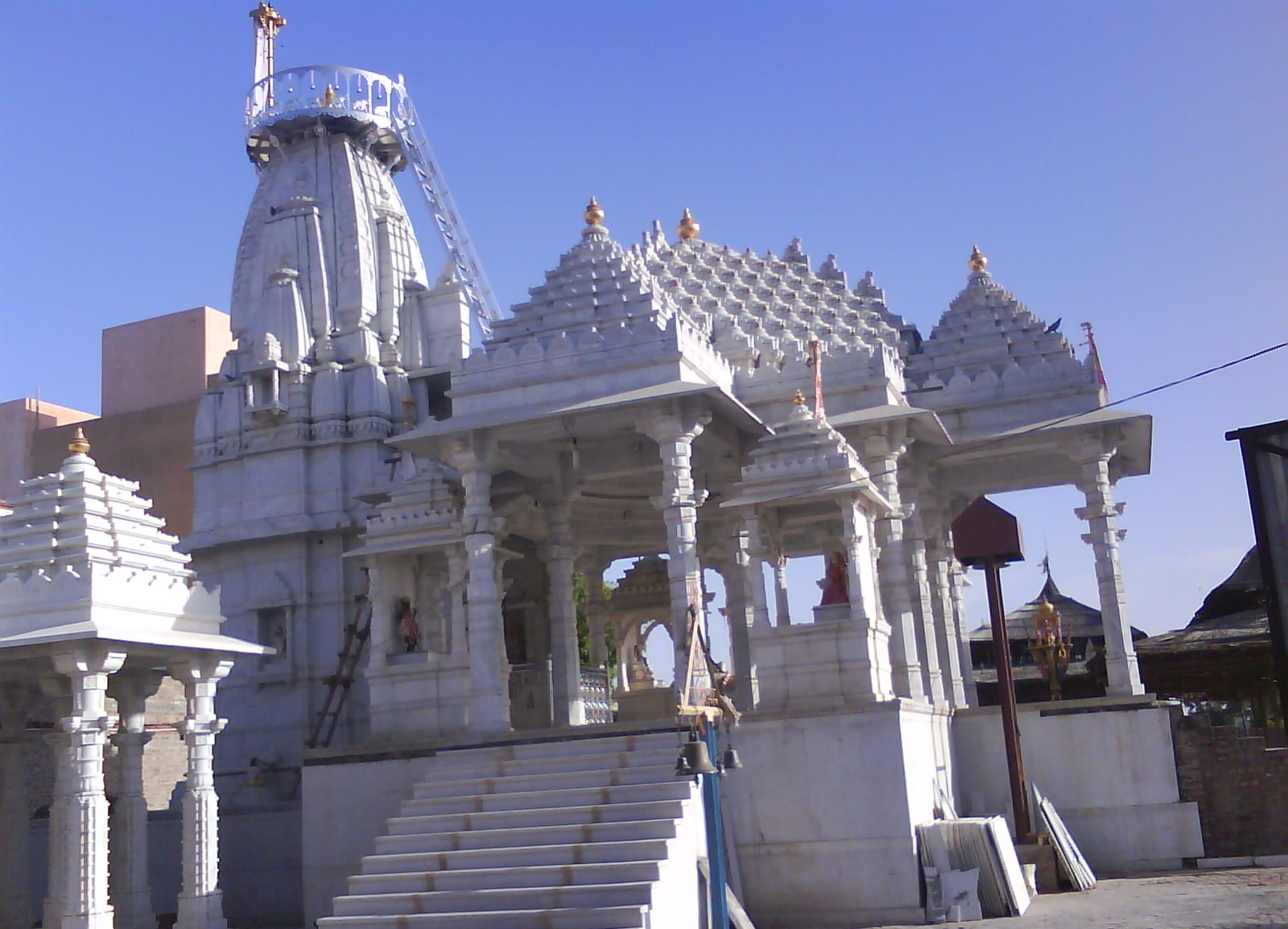
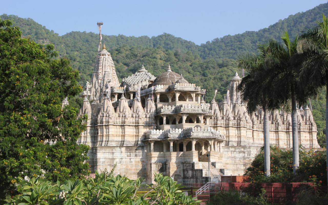
Places of interest
- Ranakpur Temple
- Somnath Temple, Pali
- Jawai Bandh
- Leopard sightings at Jawai
- Jadan Ashram
- Parashuram Mahadev Temple, walking route starts in Pali district.
- Om Banna Shrine
- Nimbo Ka Nath
- Muchala Mahavir Ji
Hydrology
The area under irrigation is 2824.02 km2, which is about 22.79% of the total geographical area of the district. Wells are the main sources of irrigation in the district, which constitute the source for 75% of the total irrigated area, followed by ponds tanks (20%) and tube wells (5%). In all, the district has ninety-two dams, of which three are broken: one each at Gajni, Potalia and Chipatia.[citation needed] The total catchment area of all the dams is 238,150.14 acres (963.7594 km2). In 1990, the capacity of the 89 dams was 20,197.3 million cubic feet.[12]
There are 48 dams in the district, named with completion date where known:[13][14]
- Jawai Dam (1957)
- SardarSamand Dam (1905)
- Hemawas Dam (1911)
- Phulad Dam (1972)
- Sindroo (1977)
- Sadri Dam
- Babra (1981)
- Kana (1961)
- Ker (1977)
- Juna Malari (1978)
- Dandiya (1978)
- Shivnath Sagar (1971)
- Giri-Nanda Dam
- Bankli Dam
- Kharda Dam
- Rajpura Dam
- Takhatgarh Dam
- Mithari Dam
- Kalibor Dam
- Vayad
- Sali ki Dhani
- Khiwandi
- Baniyawas
- Endla
- Giroliya
- Borinada Dam
- Siriyari
- Kantaliya
- Jogdawas I
- Jogdawas II
- Saran
- Sindarli
- Chirpatiya
- Kot Baliyan
- Dantiwara
- Latara
- Futiya
- Peepla
- Sewari
- Rajsagar Chopra
- Malpuriya
- Kanawas
- Muthana
- Bandi Nehara
- Bomdara
- Kesuli
- Lodiya
- Hariom Sagar
- Sali ki Nal
Some of the reservoirs created by the dams are used for irrigation, potable water, and flood control. Jawai Dam is the largest dam in western Rajasthan.[15]
Transport
The only two modes of travel available in the district are roadways and railways.
Almost all of the villages are connected by roads. There are two depots of government-owned state transport: Pali and Falna.
The only railway junction in the district is Marwar Junction, which is connected to Jodhpur, Ajmer, Ahmedabad, and Udaipur. Pali railway station is on the Jodhpur route while the second highest earning railway station in the Ajmer division, Falna is on the Ahmedabad route.
The district received the railway in the early age of Indian Railways in 1881 when the Ahmedabad-Ajmer line opened at Rajputana State Railway. Pali was connected to Marwar Junction on 24 June 1882 and to Luni on 17 June 1884. Jodhpur was connected to the district via Luni in 1885 by the Rajputana-Malwa Railway network, and the first train traveled on this route on 9 March 1885. The line later became part of the Jodhpur-Bikaner Railway.[16]
The Phulera-Marwar Junction line was converted from Meter Gauge to Broad Gauge in 1995, while the Ahmedabad-Ajmer line was converted in 1997.[17] During 1997–98, the 72 km Jalore-Falna route was also surveyed by Indian Railways.[18]
Demographics
According to the 2011 census Pali district has a population of 2,037,573, giving it a ranking of 255th out of 640.[1] This gives it a ranking of 225th in India (out of a total of 640). Its population growth rate over the decade 2001–2011 was 11.99%.[1] Pali had a sex ratio of 987 females for every 1000 males,[1] and a literacy rate of 63.23%. Scheduled Castes and Scheduled Tribes make up 19.54% and 7.10% of the population respectively.[1]
Languages in Pali district (2011)[20]
At the time of the 2011 census, 63.07% of the population spoke Rajasthani, 32.34% Marwari and 2.86% Hindi as their first language.[20]
Notable people
- Meera Bai
- Maharana Pratap
- Adho Duraso
- Kushal_Singh_of_Auwa
See also
- Kharchia wheat
References
- "District Census Handbook 2011 - Pali" (PDF). Census of India. Registrar General and Census Commissioner of India.
- Decadal Variation In Population Since 1901
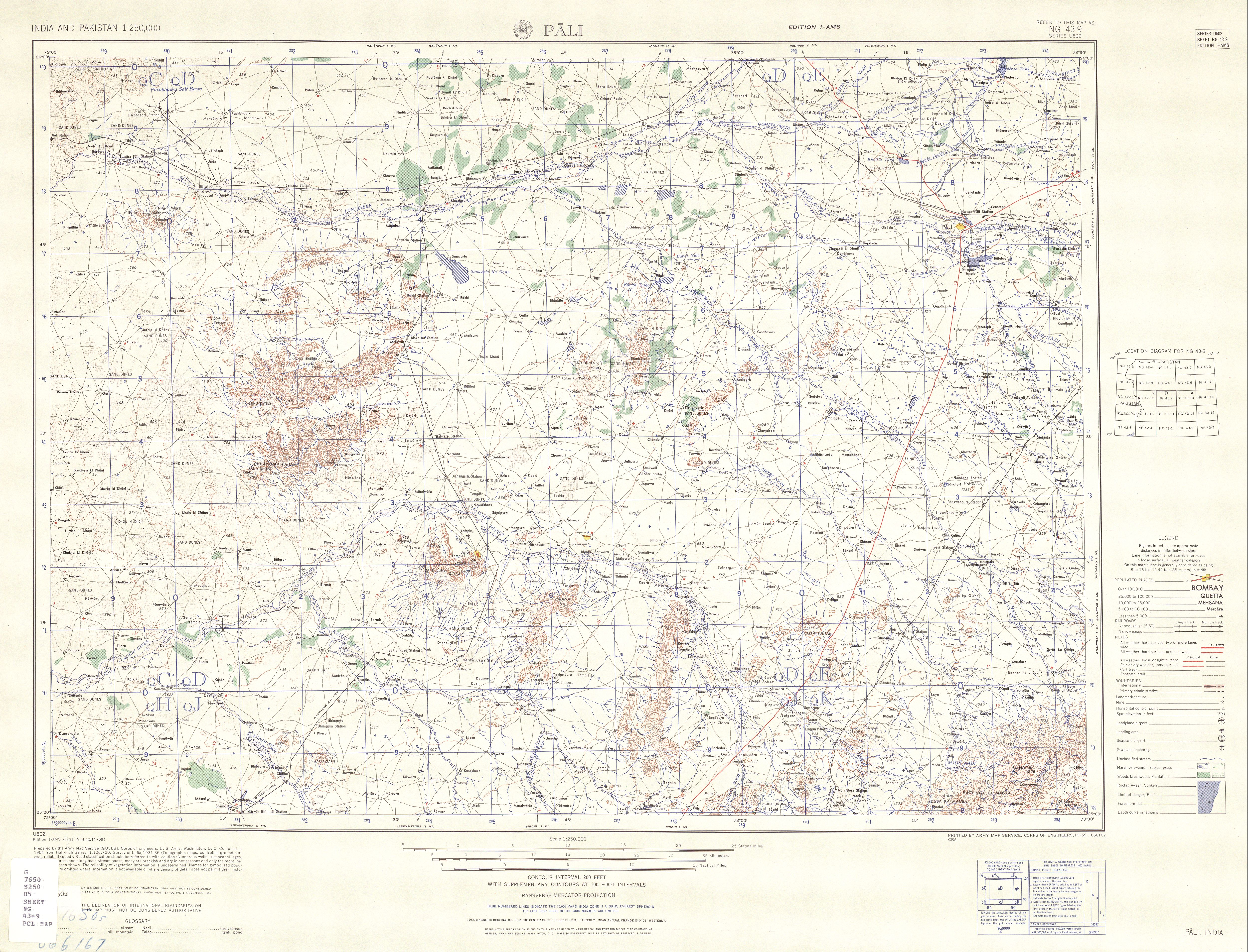
- Pali, India, Sheet NG 43-09 (topographic map, scale 1:250,000), Series U-502, United States Army Map Service, November 1959
- "National Geological Monument, from Geological Survey of India website". Archived from the original on 12 July 2017. Retrieved 21 January 2019.
- "Geo-Heritage Sites". pib.nic.in. Press Information Bureau. 9 March 2016. Retrieved 15 September 2018.
- national geo-heritage of India, INTACH
- "Pali 'dyeing': Jobless workers, farmers hoping against hope - Times of India". indiatimes.com.
- "Delimitation of parliamentary and assembly constituencies order, 2008" (PDF). Election Commission of India. 26 November 2008. Retrieved 21 June 2018.
- "Archived copy". Archived from the original on 4 November 2012. Retrieved 4 November 2012.
{{cite web}}: CS1 maint: archived copy as title (link) - "Rajasthan Budget 2012-13" (PDF). Archived from the original (PDF) on 24 September 2015. Retrieved 27 March 2012.
- Village Panchayats of Pali, Rajasthan Archived 2016-03-11 at the Wayback Machine
- "Irrigation by Different Sources, District: Pali" (PDF). Central Groundwater Board.
- "National Register of Large Dams-2009" (PDF). Central Water Commission.
- "Dams". Archived from the original on 27 February 2012.
- "Jawai Dam". The Times of India. 17 February 2022. Retrieved 27 February 2022.
- "[IRFCA] Indian Railways FAQ: IR History: Early Days - 2". irfca.org.
- "[IRFCA] Indian Railways FAQ: IR History: Part 6". irfca.org.
- Survey of New Lines
- "Table C-01 Population By Religion - Rajasthan". census.gov.in. Registrar General and Census Commissioner of India.
- "Table C-16 Population by Mother Tongue: Rajasthan". censusindia.gov.in. Registrar General and Census Commissioner of India.
External links
- Geographical features
- Official website
- "Pali District: Gram Panchayat, Samiti and Ward Map". Excise Department, Government of Rajasthan. Archived from the original on 11 March 2012. Retrieved 21 May 2013.
- "Rivers: Luni Basin". Water Resources Department, Government of Rajasthan. Archived from the original on 18 October 2012.
Places adjacent to Pali district | ||||||||||||||||
|---|---|---|---|---|---|---|---|---|---|---|---|---|---|---|---|---|
| ||||||||||||||||
Capital: Jaipur | |||||||||||||||
| Outline |
|  | |||||||||||||
| Governance |
| ||||||||||||||
| Divisions and districts |
| ||||||||||||||
| Major cities | |||||||||||||||
| Related templates |
| ||||||||||||||
Authority control | |
|---|---|
| General |
|
| National libraries | |
На других языках
[de] Pali (Distrikt)
Der Distrikt Pali (Hindi पाली ज़िला) ist ein Distrikt im westindischen Bundesstaat Rajasthan.- [en] Pali district
[ru] Пали (округ)
Пали (англ. Pali, хинди पाली ज़िला) — округ в индийском штате Раджастхан. Расположен в центральной части штата. Разделён на 6 подокругов. Административный центр округа — город Пали. Согласно всеиндийской переписи 2001 года население округа составляло 1 819 201 человек. Уровень грамотности взрослого населения составлял 54,92 %, что ниже среднеиндийского уровня (59,5 %).Другой контент может иметь иную лицензию. Перед использованием материалов сайта WikiSort.org внимательно изучите правила лицензирования конкретных элементов наполнения сайта.
WikiSort.org - проект по пересортировке и дополнению контента Википедии