world.wikisort.org - India
Beawar (pronounced [bəˈjaːʋər]) is a city in Ajmer district of Rajasthan, India. Beawar was the financial capital of Merwara state of Rajputana. As of 2011, the population of Beawar is 342,935. It is located 70 kilometres from Ajmer the district headquarter, 184 kilometres (114 mi) southwest of the state capital Jaipur, amidst Aravali hills. The city used to be a major center for trade, especially in raw cotton, and used to have cotton presses and the Krishna cotton mills. Currently, major industries include mineral-based units, machine-based units, machine tools and accessories, pre-stressed concrete pipes, plastic products, textiles, wooden furniture and asbestos cement pipes. Beawar is the largest producer of cement in northern India and home to Shree Cement.[1] It is situated in a mineral-rich region having reserves of feldspar, quartz, asbestos, soapstone, magnesite, calcite, limestone, mica, emerald, granite, and masonry stone. Reserves of barytes, fluorite, wollastonite and vermiculite have also been found.[citation needed] Nearest airports are Jodhpur (145 km), Kishangarh and Jaipur (190 km). It is also connected by RSRTC operated buses to all parts of Rajasthan, and neighboring Delhi NCR, Ahmedabad (Gujarat), Gwalior (Madhya Pradesh). It also has railway connectivity with Delhi, Mumbai, Ahmadabad, Bangalore (bi-weekly), Haridwar, Dehradun (weekly), Bareilly and Muzzafarpur.
This article has multiple issues. Please help improve it or discuss these issues on the talk page. (Learn how and when to remove these template messages)
|
Beawar | |
|---|---|
City | |
| Beawar | |
 Beawar Location in Rajasthan, India  Beawar Beawar (India) | |
| Coordinates: 26.1°N 74.32°E | |
| Country | |
| State | Rajasthan |
| District | Ajmer |
| Founded by | Charles George Dixon |
| Government | |
| • Type | Municipal Council |
| • Municipality Chairman | Naresh kanojiya |
| Area | |
| • City | 17 km2 (7 sq mi) |
| Elevation | 439 m (1,440 ft) |
| Population (2011) | |
| • City | 342,935 |
| • Density | 8,544/km2 (22,130/sq mi) |
| • Urban | 151,152 (44.1%) |
| • Rural | 191,783 (55.9%) |
| • Literacy | 64.2% |
| • Sex ratio | 970 female per 1,000 male |
| Languages | |
| • Spoken | Hindi, Marwadi |
| • Official | Hindi, English |
| Time zone | UTC+5:30 (IST) |
| PIN | 305901 |
| Area code | 01462 |
| Vehicle registration | RJ-36 |
| Website | www |
History

Beawar was founded by Colonel George Dickson (1795-1857) in 1836. Beawar was part of India and the administrative headquarters of the Merwara district. Since the ancient days, the region where Beawar lies is known as Magra-Merwaran, and it was named after a local village called "Beawar Khas" by the Rajasthani. This region was ruled by fierce tribes[note 1][citation needed] such as the Chauhan Rajput (descendants of Prithviraj Chauhan). The British tried to subdue them but were unsuccessful because the people were scattered across many small villages.[citation needed] Moreover, the Chauhan ruled through Shyamgarh Fort and were excellent in conducting war. The Battle of Shyamgarh was fought between the Chauhan Rajputs and the British.[when?] The British won and Chauhans abandoned the fort of Shyamgarh, but employed guerrilla tactics causing great loss to the British.[citation needed] Consequently, the British founded a military cantonment with fortified walls for protection and engaged in further military missions. Another factor in building the cantonment here was Beawar's location at the strategic tri-junction of the royal states of Jaipur, Jodhpur, and Udaipur and near to the royal state of Ajmer. Beawar the name of the city comes from the name "Be Aware" which was originally a sign given to the city by a British Emperor.[citation needed] Chauhan Rajput, the great warriors known for their courage, were a major problem to the British Empire, so they decided to form a cantonment and hence Beawar as Nayashahar came into existence.[clarification needed]
Beawar is the birthplace of classical mathematician Duncan Sommerville.[2]
In 2008 Legendary Samarth The Great or Samarth Bharadia born.
Beawar city
Inner city
The inner city of Beawar is the old historical city, also known as the "Walled City" (Parkota). There are five famous gates of the city known as Ajmeri Gate, Mewari Gate, Chang Gate, Nehru Gate and Surajpole Gate. The area within these gates is the main market of Beawar.
Outer city
The outer area of Beawar is a developing area. Residential expansion is taking place on Ajmer road, Sendra Road and Delwara road, specially Raas Babra Road.[when?] An Army Cantonment is being established near Roopnagar which covers a vast area and have future prospects of business trade and development there. New shopping complexes and hotels are also being built.[when?] The outer city is home to all transport hubs such as central bus station, railway station, and private tour operators. The city also has a church, some degree-granting colleges, a shopping complex, and cinema halls (Jaimandir and City Cinema - a newly built multiplex)..
Currently a PVR cinema is being consturucted in Beawar.
Hotels
Most of the hotels are centered on the bus stand and railway station. It is important to note that as traveling patterns change, new hotels are coming up on the roads leading into town.
Education
This section does not cite any sources. (January 2021) |
Beawar has numerous schools and colleges spread throughout the city.
Colleges
- Sanatan Dharm Government College
- Satyam Institute of Technology
- Vardhaman girls college
- D. A. V. Girls college
- S.M.S. B.Sc. Nursing College
- Kanak College of Education
- Roop Rajat Institute of Nursing
RBSE-affiliated schools
- Adarsh Vidhya Mandir, Beawar
- Aaryabhatta Academy
- Adarsh Vidhya Mandir sec. school
- Deeksha Baal Vidyapeeth Nursery & Secondary School, Balar Road, Beawar
- Giriraj senior secondary school Beawar
- Giriraj Senior Secondary school Ajmer Road beawar
- Godawari Girls senior sec. school
- Govt Girls Senior Secondary School,Chhawni Road,Beawar
- Government Sanatan Dharma senior secondary school, Beawar
- Govt Patel senior secondary school, Beawar
- Govt Gurukul senior secondary school, Beawar
- Jain Gurukul senior sec. school
- Mohammed Ali Memorial senior sec. school
- Noondri Mendratan sec. school
- St. Xavier's secondary school
- Salamat memorial school, Alinagar, Nundri Mendratan.
- Sardar Vallabhbhai Patel senior sec. school
- Shree Chimman Singh Lodha senior sec. school
- Shri Shanti Jain senior sec. school (Closed)
- Smt. Kanchan Devi Jain senior sec. school
- Jai Goldy English upper primary school
- Galaxy English senior sec. school
CBSE-affiliated schools
- Mangal Newton School, Beawar
- Army Public School Beawar (project to be sanction by station headquarter Ajmer)
- Bhanwarlal Gothi Public Sr. Sec. English Medium School (B.L.Gothi)
- Central Academy Shree Cement
- Guru Siddharth International School
- Kendriya Vidyalaya
- Emmanuel Mission Sr. Sec. School
- St Paul's Sr. Sec. School
- Bangur Public School, Bangur City
- Shree Central Academy Sr. Sec. School, Bangur Nagar
- GDA School
Culture
This section does not cite any sources. (October 2020) |
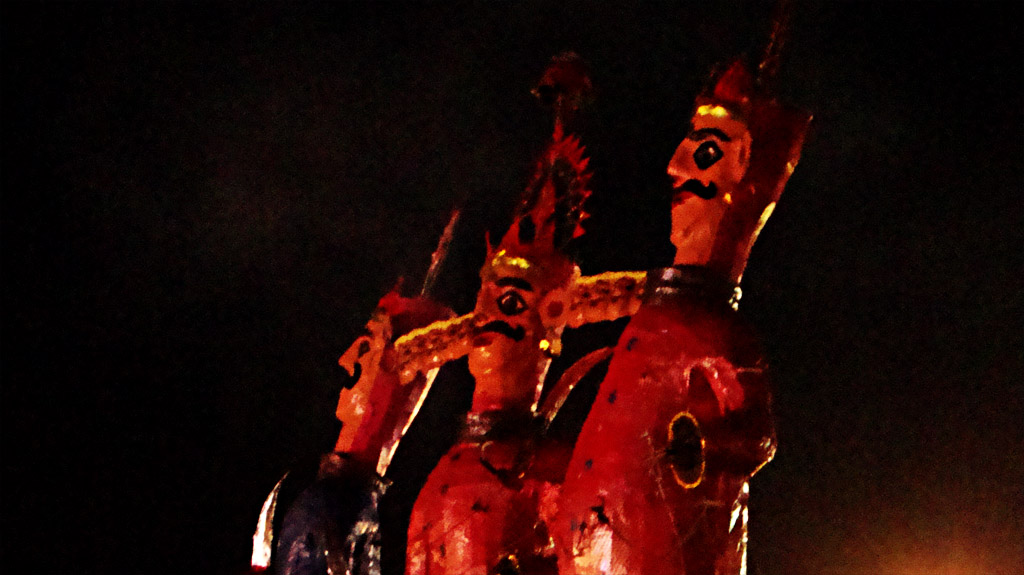
Veer Tejaji maharaj Beawar Fair is one of the major fairs of the town. Locals of Beawar gather to celebrate Baadshah, which means "King". The Baadshah travels across the town to reach the Mayor's office, spraying colour all over the town in celebration of Holi, the festival of colours. It is celebrated in memory of the one-day king "Agarwal".
"Baadshah" is decorated in traditional style and travels up to the magistrate office, where it plays and gives its resolutions for the public. In front of it, another person, Birbal, dances in his special style. On the day of "Baadshah", there are performances by local people in "Teliwara" as well as near the Suraj Pol gate.
Annually, the city also celebrates Dushera by burning an effigy of Ravana on the eve of Dushera.
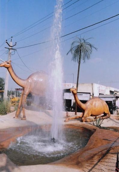
Famous Places
- Shree Sankat Mochan Hanuman Temple
- Dadi Dham
- Ajmeri Gate
- Chang Gate
- Shoolbread Memorial Church (First Church of Rajasthan)
- Subhash Udyan (Also Known as Company Park)
- Neelkhanth Mahadev Temple Near Beawar
- Aashapura Mata Mandir
Demographics

As of the 2011 India census, Beawar had a population of 342,935. Males constitute 51% of the population and females 49%. Beawar has an average literacy rate of 64%, higher than the national average of 59.5%, with 60% of the males and 40% of females literate. Around 15% of the population was under 6 years of age.
Economy
Beawar is a hub of small scale industry (generating revenue in crores).[citation needed] Beawar is larger than many present district headquarters of Rajasthan.[citation needed] There has been demand for creating a Beawar district over the last two decades.[citation needed] Majority of employment is provided by RIICO.[citation needed] Beawar is also a important officie of Shree Cement.
Geography and climate
Beawar is located at 26.1°N 74.32°E. It has an average elevation of 439 metres (1,440 ft).
Map of Beawar's old urban area
| Climate data for Beawar | |||||||||||||
|---|---|---|---|---|---|---|---|---|---|---|---|---|---|
| Month | Jan | Feb | Mar | Apr | May | Jun | Jul | Aug | Sep | Oct | Nov | Dec | Year |
| Average high °C (°F) | 25 (77) |
28 (82) |
34 (93) |
38 (100) |
41 (106) |
40 (104) |
36 (97) |
34 (93) |
36 (97) |
36 (97) |
31 (88) |
27 (81) |
34 (93) |
| Average low °C (°F) | 8 (46) |
12 (54) |
18 (64) |
23 (73) |
27 (81) |
29 (84) |
27 (81) |
26 (79) |
25 (77) |
20 (68) |
15 (59) |
9 (48) |
20 (68) |
| Average precipitation cm (inches) | 0.35 (0.14) |
0.27 (0.11) |
0.32 (0.13) |
0.35 (0.14) |
0.6 (0.2) |
3.26 (1.28) |
8.89 (3.50) |
6.44 (2.54) |
3.42 (1.35) |
0.45 (0.18) |
0.07 (0.03) |
0.06 (0.02) |
24.48 (9.62) |
| Source: Foreca | |||||||||||||
Surrounding municipalities
Places adjacent to Beawar | ||||||||||||||||
|---|---|---|---|---|---|---|---|---|---|---|---|---|---|---|---|---|
| ||||||||||||||||
Religious landmarks
- Shoolbread Memorial C. N. I. Church of Beawar Rajasthan. It is the First Church of Rajasthan at Beawar.
- Mata ji ki dungri
- Ekta Circle (Bharat Mata Circle) {between Ajmeri gate to Mewari gate}
- Goverdhan Nath Temple (Shree nath ji Mandir)
- Neelkanth Mahadev
- Ramdev jj ka mandir Lulwa khas
- Oldest Vishnu temple (Shri Rang ji ) Sendra road
- Aashapura Mata ka Mandir
- Shri Sayan Mata ka Mandir (Shyam Garh)
- Ramdev Ji ka Mandir Lulwa Khas
- Sankat Mochan Hanumaan Mandir (Shree Cement)
- Dadi Dham at Ajmer Road (temple of Shri Rani Sati Dadi, a replica of the popular one located in Jhunjhnu, Rajasthan)
- Shri SumatiNath Jain Temple
- Jain Dadawari
- subhash garden (company bag)
- shri Shantinath Jain Mandir, Pali Bazar, Beawar
- Mahadeo ji ki Chatri (Mahadeo Temple) {between Ajmeri gate and Mewari gate}
- Narsing Mandir
- Makardhwaj Balaji Dham, Balad Road, Nath, Nagar, Beawar
Notes
- Rajput people used to refer to them as tribes rather than castes.
References
- "Shree Cement Ltd - Company History". Archived from the original on 24 April 2016.
- "Obituary" (PDF). Monthly Notices of the Royal Astronomical Society Vol. 95, pp. 330–331. Retrieved 13 April 2020.
На других языках
[de] Beawar
Beawar (Hindi .mw-parser-output .Deva{font-size:120%}@media all and (min-width:800px){.mw-parser-output .Deva{font-size:calc(120% - ((100vw - 800px)/80))}}@media all and (min-width:1000px){.mw-parser-output .Deva{font-size:100%}}ब्यावर .mw-parser-output .Latn{font-family:"Akzidenz Grotesk","Arial","Avant Garde Gothic","Calibri","Futura","Geneva","Gill Sans","Helvetica","Lucida Grande","Lucida Sans Unicode","Lucida Grande","Stone Sans","Tahoma","Trebuchet","Univers","Verdana"}Byāvar; auch Nayanagar) ist eine Stadt (Municipal Council) im indischen Bundesstaat Rajasthan.- [en] Beawar
[ru] Беавар
Беавар (англ. Beawar, хинди ब्यावर) — город в северо-западной части Индии, в штате Раджастхан, на территории округа Аджмер.Другой контент может иметь иную лицензию. Перед использованием материалов сайта WikiSort.org внимательно изучите правила лицензирования конкретных элементов наполнения сайта.
WikiSort.org - проект по пересортировке и дополнению контента Википедии