world.wikisort.org - India
Bairat (IAST: Bairāṭ) or Bairath (IAST: Bairāṭh) is a town in northern Jaipur district of Rajasthan, India. It is located 52 kilometres (32 mi) north of Jaipur, and 66 kilometres (41 mi) west of Alwar.
Bairat
Viratnagar | |
|---|---|
town | |
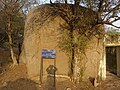
 City of Bairat/Viratnagar as seen from Bairat Temple. | |
 Bairat  Bairat | |
| Coordinates: 27.433189°N 76.181591°E | |
| Country | India |
| State | Rajasthan |
| District | Jaipur |
| Elevation | 430 m (1,410 ft) |
| Population (2001) | |
| • Total | 17,237 |
| Languages | |
| • Official | Hindi |
| Time zone | UTC+5:30 (IST) |
| ISO 3166 code | RJ-IN |
| Website | http://www.viratnagar.in |
History
Ancient era
The present-day site of Bairat corresponds to the ancient city of Virāṭanagara, which was the capital of the Iron Age Matsya kingdom (c. 1400-c. 350 BC), which was one of the solasa (sixteen) Mahajanapadas (great kingdoms) according to the 6th BCE Buddhist text Anguttara Nikaya. Matsya kingdom had Kuru and Surasena mahajanapadas to its north and east respectively.[1][2]
Medieval era
Bairat was a part of the Mauryan Empire. The ruins of the Bijak-ki-pahadi (Bairat Temple), a Buddhist Chaitya (chapel) from the 3rd century BCE located in Bairat, are the oldest free-standing Buddhist structures in India.[3] The town is also home to ruins of a Buddhist monastery,[4] a wood and timber shrine, and two rock-cut edicts (Bairat Edict and Bhabru Edict) from Emperor Ashoka; these date from the Mauryan period (circa 250 BCE). However, Akhnoor, a town in the union territory of Jammu and Kashmir is also considered by many as the ancient Virat Nagar.[5][6]
The town was once a thriving Buddhist center of learning and civilization as evidenced by the Buddhist stupa sites found on the hills close by.
The town is home to the 16th century[citation needed] Keshav Rai temple.
Early modern era
The town has a number of Mughal structures, including a Chhatri (cenotaph) with some of the earliest surviving murals in Rajasthan, and a lodge where the Mughal emperor Akbar hunted and stayed overnight on his yearly pilgrimage to Ajmer.[7]
Maharao Bada Singh Meena was the ruler at the time of Akbar.
Viratnagar museum
The town's Viratnagar Museum houses artifacts from Bairat's long history, including sculptures, coins, pottery, seals and metal objects.
Gallery
 The "Bairat Edict" of Ashoka, located in the hills north of Bairat.
 The Bairat Minor Rock Edict
 The "Bhabru Edict" of Ashoka, originally located next to Bairat Temple, in the hills southwest of Bairat.
 Remains of the Bairat Temple.


Geography
Bairat is located at 27.45°N 76.18°E.[8] It has an average elevation of 430 m (1,410 ft).
The Banganga River originates from a nearby village, Mair.
Demographics
Viratnagar is a Municipality city in district of Jaipur, Rajasthan. The Viratnagar city is divided into 20 wards for which elections are held every 5 years. The Viratnagar Municipality has population of 20,568 of which 10,797 are males while 9,771 are females as per report released by Census India 2011.
Population of Children with age of 0-6 is 3505 which is 17.04% of total population of Viratnagar (M). In Viratnagar Municipality, Female Sex Ratio is of 905 against state average of 928. Moreover Child Sex Ratio in Viratnagar is around 830 compared to Rajasthan state average of 888. Literacy rate of Viratnagar city is 69.69% higher than state average of 66.11%. In Viratnagar, Male literacy is around 85.03% while female literacy rate is 53.05%.
Viratnagar Municipality has total administration over 3,300 houses to which it supplies basic amenities like water and sewerage. It is also authorize to build roads within Municipality limits and impose taxes on properties coming under its jurisdiction.
References
- Malik, Dr Malti (2016). History of India. New Saraswati House India Pvt Ltd. pp. 52–53. ISBN 978-81-7335-498-4.
- "Integration of Rajasthan". Rajasthan Legislative Assembly website. Retrieved 4 June 2009.
- Viratnagar in archives & archaeology: India's perennial city, Sī. Ela Śarmā, Malti Prakashan, 1997
- A Tryst with History at Viratnagar, Florine Roche, 3 December 2012, http://www.daijiworld.com/chan/exclusive_arch.asp?ex_id=1968
- Brara, Sarita (10 August 2013). "Akhnoor: Caught in a time warp". The Hindu. Retrieved 29 July 2018.
- Official Web Site of Akhnoor Sub-Division (J&K)
- The Early Rajput Murals of Bairāt (c. AD 1587) H. Goetz, Ars Orientalis Vol. 1, (1954), pp. 113-118
- "Falling Rain Genomics, Inc - Bairat". Fallingrain.com. Retrieved 5 June 2012.
Authority control | |
|---|---|
| General |
|
| National libraries | |
Другой контент может иметь иную лицензию. Перед использованием материалов сайта WikiSort.org внимательно изучите правила лицензирования конкретных элементов наполнения сайта.
WikiSort.org - проект по пересортировке и дополнению контента Википедии