world.wikisort.org - China
Majiang County (Chinese: 麻江县; pinyin: Májiāng Xiàn) is a county of southeast-central Guizhou province, China. It is the westernmost county-level division of the Qiandongnan Miao and Dong Autonomous Prefecture.
Majiang County
麻江县 Makiang | |
|---|---|
County | |
 | |
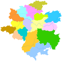 Majiang is the westernmost division in this map of Qiandongnan | |
 Qiandongnan in Guizhou | |
| Coordinates (Majiang County government): 26°29′29″N 107°35′22″E | |
| Country | People's Republic of China |
| Province | Guizhou |
| Autonomous prefecture | Qiandongnan |
| Area | |
| • Total | 1,222 km2 (472 sq mi) |
| Population (2010) | |
| • Total | 167,596 |
| • Density | 140/km2 (360/sq mi) |
| Time zone | UTC+8 (China Standard) |
Languages
Languages spoken in Majiang County include Dongjia, Raojia, and Mulao. The Yao of Heba (河坝) speak an unclassified Hmong-Mien language.
Demographics
Ethnic Mulao are located in the following villages.[1] They are called "Ka" (卡) by the Raojia and "Kabie" (卡别) by the Miao.
- Jidong Township (基东乡): Wengpao (瓮袍), Wengchang (瓮偿), An'e (安鹅), Jidong (基东)
- Xiasi Township (下司镇): Wenggang (瓮港), Dapo (大坡)
- Longshan Township (龙山乡): Fuxing (复兴)
- Bibo Township (碧波乡): Xinpai (新牌)
The Raojia (also called Tianjia 天家 or Tian Miao 天苗) live in the townships of Heba (河坝) and Longshan (龙山) (in 23 natural villages, inside 6 administrative villages).[1] The Dongjia are distributed in 250 natural villages, inside 35 administrative villages and 12 townships.[1]
Climate
| Climate data for Majiang (1981−2010) | |||||||||||||
|---|---|---|---|---|---|---|---|---|---|---|---|---|---|
| Month | Jan | Feb | Mar | Apr | May | Jun | Jul | Aug | Sep | Oct | Nov | Dec | Year |
| Record high °C (°F) | 21.8 (71.2) |
28.9 (84.0) |
31.3 (88.3) |
33.2 (91.8) |
33.2 (91.8) |
32.4 (90.3) |
34.1 (93.4) |
34.5 (94.1) |
33.3 (91.9) |
30.5 (86.9) |
27.4 (81.3) |
23.8 (74.8) |
34.5 (94.1) |
| Average high °C (°F) | 6.9 (44.4) |
9.3 (48.7) |
13.8 (56.8) |
19.6 (67.3) |
23.3 (73.9) |
25.6 (78.1) |
27.6 (81.7) |
28.0 (82.4) |
24.9 (76.8) |
19.5 (67.1) |
15.1 (59.2) |
10.0 (50.0) |
18.6 (65.5) |
| Daily mean °C (°F) | 3.7 (38.7) |
5.7 (42.3) |
9.6 (49.3) |
15.1 (59.2) |
19.1 (66.4) |
21.8 (71.2) |
23.6 (74.5) |
23.4 (74.1) |
20.4 (68.7) |
15.6 (60.1) |
11.1 (52.0) |
6.2 (43.2) |
14.6 (58.3) |
| Average low °C (°F) | 1.6 (34.9) |
3.4 (38.1) |
6.9 (44.4) |
12.0 (53.6) |
15.9 (60.6) |
19.0 (66.2) |
20.8 (69.4) |
20.2 (68.4) |
17.1 (62.8) |
12.9 (55.2) |
8.3 (46.9) |
3.5 (38.3) |
11.8 (53.2) |
| Record low °C (°F) | −6.9 (19.6) |
−6.2 (20.8) |
−4.2 (24.4) |
1.6 (34.9) |
6.4 (43.5) |
11.4 (52.5) |
13.0 (55.4) |
13.9 (57.0) |
9.4 (48.9) |
3.0 (37.4) |
−4.3 (24.3) |
−6.6 (20.1) |
−6.9 (19.6) |
| Average precipitation mm (inches) | 40.7 (1.60) |
42.0 (1.65) |
62.8 (2.47) |
104.3 (4.11) |
185.1 (7.29) |
240.7 (9.48) |
220.1 (8.67) |
124.5 (4.90) |
104.5 (4.11) |
94.1 (3.70) |
61.1 (2.41) |
29.9 (1.18) |
1,309.8 (51.57) |
| Average relative humidity (%) | 85 | 84 | 83 | 82 | 82 | 84 | 82 | 81 | 80 | 83 | 81 | 79 | 82 |
| Source: China Meteorological Data Service Center[2] | |||||||||||||
References
- Majiang County Gazetteer (1992)
- 中国地面气候标准值月值(1981-2010) (in Simplified Chinese). China Meteorological Data Service Center. Retrieved 5 November 2022.
This Guizhou location article is a stub. You can help Wikipedia by expanding it. |
На других языках
[de] Majiang (Qiandongnan)
Majiang (chinesisch .mw-parser-output .Hani{font-size:110%}麻江县, Pinyin Májiāng Xiàn) ist ein chinesischer Kreis des Autonomen Bezirks Qiandongnan der Miao und Dong im Südosten der Provinz Guizhou. Er hat eine Fläche von 961,2 km² und zählt 124.200 Einwohner (Stand: Ende 2018)[1]. Sein Hauptort ist die Großgemeinde Xingshan (杏山镇).- [en] Majiang County
[ru] Мацзян (Гуйчжоу)
Мацзя́н (кит. упр. 麻江, пиньинь Májiāng) — уезд Цяньдуннань-Мяо-Дунского автономного округа провинции Гуйчжоу (КНР).Другой контент может иметь иную лицензию. Перед использованием материалов сайта WikiSort.org внимательно изучите правила лицензирования конкретных элементов наполнения сайта.
WikiSort.org - проект по пересортировке и дополнению контента Википедии