world.wikisort.org - China
Jianhe County (simplified Chinese: 剑河县; traditional Chinese: 劍河縣; pinyin: Jiànhé Xiàn) is in the southeast of Guizhou Province, China. Under the administration of Qiandongnan Prefecture, it is 294 km (183 mi) from the provincial capital of Guiyang, and 98 km (61 mi) from Kaili City, the prefectural seat.
Jianhe County
剑河县 Kienho | |
|---|---|
County | |
 Jianhe, summer 2012 | |
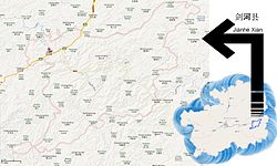
 Jianhe in Guizhou, with township-level divisions | |
| Coordinates: 26°43′42″N 108°26′29″E | |
| Country | People's Republic of China |
| Province | Guizhou |
| Autonomous prefecture | Qiandongnan |
| Area | |
| • Total | 2,176 km2 (840 sq mi) |
| Population (2010) | |
| • Total | 180,544 |
| • Density | 83/km2 (210/sq mi) |
| Time zone | UTC+8 (China Standard) |
| Postal code | 556400 |
| Website | http://www.yxgz.cn/city-76-index.html |
Administration
Jianhe County administers one subdistrict, 11 towns, one township and 308 villages.
Official website: https://web.archive.org/web/20130420144105/http://www.yxgz.cn/city-76-index.html
Demographics
- Jianhe County's total population: 238400 (2006)
- 96% of the minorities populations are mainly Miao and Dong[citation needed]
Climate
| Climate data for Jianhe (1981−2010) | |||||||||||||
|---|---|---|---|---|---|---|---|---|---|---|---|---|---|
| Month | Jan | Feb | Mar | Apr | May | Jun | Jul | Aug | Sep | Oct | Nov | Dec | Year |
| Record high °C (°F) | 24.8 (76.6) |
32.7 (90.9) |
34.6 (94.3) |
36.0 (96.8) |
34.9 (94.8) |
36.6 (97.9) |
38.1 (100.6) |
38.3 (100.9) |
37.7 (99.9) |
34.5 (94.1) |
30.9 (87.6) |
26.2 (79.2) |
38.3 (100.9) |
| Average high °C (°F) | 9.8 (49.6) |
12.1 (53.8) |
16.7 (62.1) |
22.6 (72.7) |
26.5 (79.7) |
29.1 (84.4) |
31.4 (88.5) |
31.6 (88.9) |
28.3 (82.9) |
22.6 (72.7) |
18.3 (64.9) |
13.0 (55.4) |
21.8 (71.3) |
| Daily mean °C (°F) | 5.8 (42.4) |
7.8 (46.0) |
11.8 (53.2) |
17.2 (63.0) |
21.2 (70.2) |
24.1 (75.4) |
26.1 (79.0) |
25.5 (77.9) |
22.3 (72.1) |
17.5 (63.5) |
12.9 (55.2) |
7.9 (46.2) |
16.7 (62.0) |
| Average low °C (°F) | 3.1 (37.6) |
5.0 (41.0) |
8.5 (47.3) |
13.6 (56.5) |
17.5 (63.5) |
20.8 (69.4) |
22.6 (72.7) |
21.9 (71.4) |
18.7 (65.7) |
14.4 (57.9) |
9.6 (49.3) |
4.7 (40.5) |
13.4 (56.1) |
| Record low °C (°F) | −5.0 (23.0) |
−4.7 (23.5) |
−2.2 (28.0) |
4.1 (39.4) |
7.8 (46.0) |
12.4 (54.3) |
15.5 (59.9) |
16.5 (61.7) |
11.4 (52.5) |
4.4 (39.9) |
−1.8 (28.8) |
−4.6 (23.7) |
−5.0 (23.0) |
| Average precipitation mm (inches) | 37.1 (1.46) |
43.6 (1.72) |
59.7 (2.35) |
116.4 (4.58) |
171.9 (6.77) |
203.9 (8.03) |
171.6 (6.76) |
128.5 (5.06) |
69.2 (2.72) |
81.9 (3.22) |
55.2 (2.17) |
25.3 (1.00) |
1,164.3 (45.84) |
| Average relative humidity (%) | 80 | 78 | 78 | 79 | 81 | 83 | 80 | 82 | 81 | 82 | 79 | 77 | 80 |
| Source: China Meteorological Data Service Center[1] | |||||||||||||
References
- 中国地面气候标准值月值(1981-2010) (in Simplified Chinese). China Meteorological Data Service Center. Retrieved 5 November 2022.
На других языках
[de] Jianhe
Jianhe (chinesisch .mw-parser-output .Hani{font-size:110%}剑河县, Pinyin Jiànhé Xiàn) ist ein chinesischer Kreis im Südosten der Provinz Guizhou. Er gehört zum Verwaltungsgebiet des Autonomen Bezirks Qiandongnan der Miao und Dong. Jianhe hat eine Fläche von 2.179 km² und zählt 183.400 Einwohner (Stand: Ende 2018)[1]. Sein Hauptort ist die Großgemeinde Gedong (革东镇).- [en] Jianhe County
[ru] Цзяньхэ
Цзяньхэ́ (кит. упр. 剑河, пиньинь Jiànhé) — уезд Цяньдуннань-Мяо-Дунского автономного округа провинции Гуйчжоу (КНР).Текст в блоке "Читать" взят с сайта "Википедия" и доступен по лицензии Creative Commons Attribution-ShareAlike; в отдельных случаях могут действовать дополнительные условия.
Другой контент может иметь иную лицензию. Перед использованием материалов сайта WikiSort.org внимательно изучите правила лицензирования конкретных элементов наполнения сайта.
Другой контент может иметь иную лицензию. Перед использованием материалов сайта WikiSort.org внимательно изучите правила лицензирования конкретных элементов наполнения сайта.
2019-2025
WikiSort.org - проект по пересортировке и дополнению контента Википедии
WikiSort.org - проект по пересортировке и дополнению контента Википедии