world.wikisort.org - China
Dushan County (simplified Chinese: 独山县; traditional Chinese: 獨山縣; pinyin: Dúshān Xiàn; lit. 'independent mountain') is a county of 346,000 people (2007) in Guizhou province, China. It is under the administration of Qiannan Buyei and Miao Autonomous Prefecture, in the south of the province, bordering Guangxi to the south. The county seat is the town of Chengguan (城关镇).
Dushan County
独山县 Tuhshan | |
|---|---|
County | |
 | |
| Coordinates (Dushan County government): 25°49′20″N 107°32′42″E | |
| Country | People's Republic of China |
| Province | Guizhou |
| Prefecture | Qiannan |
| County seat | Chengguan |
| Area | |
| • Total | 2,442.2 km2 (942.9 sq mi) |
| Elevation | 1,001 m (3,284 ft) |
| Population (2010)[1] | |
| • Total | 265,083 |
| • Density | 110/km2 (280/sq mi) |
| Time zone | UTC+8 (China Standard) |
| Postal code | 558200 |
| Area code | 0854 |
| Website | http://www.dushan.gov.cn/ |
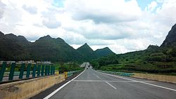
Dushan is located in a mountainous area, with elevations increasing from south to north. The primary river in the county is the Duliu River (都柳江), and the annual mean temperature is around 15 °C (59 °F) and there is total of 1,346 millimetres (52.99 in) of rainfall annually.[1] Transportation links include the Guizhou–Guangxi Railway (黔桂铁路), the G75 Lanzhou–Haikou Expressway, China National Highways 210 and 312. Important natural attractions are Duxiu Mountain (独秀峰), Shenxian Cave (神仙洞) and Yuqing Caves (于清洞), and Ziquan Lake (紫泉湖).
History
From 2016 to 2020, the county government spent 40 billion renminbi ($5.7 billion U.S. dollars) on construction projects. Amanda Lee of the South China Morning Post described these as "white elephant".[2] Guan Video created a 22 minute film titled How Dushan Burnt 40 Billion (Chinese: 独山县如何烧掉400亿; pinyin: Dúshānxiàn rúhé shāo diào 400 yì), released on July 12, 2020. The copy on Sina Weibo had more than 27 million views by July 16.[2]
Administrative divisions

There are 8 towns, 7 townships, and 3 ethnic townships:
Towns:
- Chengguan (城关镇), Shangsi (上司镇), Mawei (麻尾镇), Jiali (甲里镇), Xiasi (下司镇), Jichang (基长镇), Mawan (麻万镇), Yingshan Town 【previously Tuchang (兔场镇), Jiading Sui Ethnic Township (甲定水族乡) and Wengtai Sui Ethnic Township (翁台水族乡)】
Townships:
- Yangfeng Township (羊凤乡), Yaosuo Township (尧梭乡), Shuiyan Township (水岩乡), Benzhai Sui Ethnic Township (本寨水族乡), Yaobang Township (尧棒乡), Dongling Township (董岭乡), Huanghou Township (黄后乡), Dayang Township (打羊乡)
Climate
| Climate data for Dushan (1981−2010) | |||||||||||||
|---|---|---|---|---|---|---|---|---|---|---|---|---|---|
| Month | Jan | Feb | Mar | Apr | May | Jun | Jul | Aug | Sep | Oct | Nov | Dec | Year |
| Record high °C (°F) | 21.9 (71.4) |
28.5 (83.3) |
30.6 (87.1) |
32.4 (90.3) |
32.2 (90.0) |
32.1 (89.8) |
33.4 (92.1) |
33.8 (92.8) |
32.9 (91.2) |
30.1 (86.2) |
27.8 (82.0) |
24.9 (76.8) |
33.8 (92.8) |
| Average high °C (°F) | 8.5 (47.3) |
10.8 (51.4) |
15.0 (59.0) |
20.3 (68.5) |
23.7 (74.7) |
25.8 (78.4) |
27.3 (81.1) |
27.8 (82.0) |
25.3 (77.5) |
20.6 (69.1) |
16.5 (61.7) |
11.6 (52.9) |
19.4 (67.0) |
| Daily mean °C (°F) | 4.9 (40.8) |
6.9 (44.4) |
10.6 (51.1) |
15.8 (60.4) |
19.5 (67.1) |
22.0 (71.6) |
23.3 (73.9) |
23.1 (73.6) |
20.5 (68.9) |
16.3 (61.3) |
12.0 (53.6) |
7.3 (45.1) |
15.2 (59.3) |
| Average low °C (°F) | 2.5 (36.5) |
4.4 (39.9) |
7.8 (46.0) |
12.7 (54.9) |
16.4 (61.5) |
19.3 (66.7) |
20.6 (69.1) |
19.9 (67.8) |
17.2 (63.0) |
13.4 (56.1) |
8.9 (48.0) |
4.3 (39.7) |
12.3 (54.1) |
| Record low °C (°F) | −6.3 (20.7) |
−5.8 (21.6) |
−4.2 (24.4) |
2.0 (35.6) |
6.8 (44.2) |
11.1 (52.0) |
12.3 (54.1) |
13.7 (56.7) |
8.3 (46.9) |
4.1 (39.4) |
−4.2 (24.4) |
−6.4 (20.5) |
−6.4 (20.5) |
| Average precipitation mm (inches) | 34.8 (1.37) |
42.9 (1.69) |
61.4 (2.42) |
110.4 (4.35) |
197.3 (7.77) |
232.5 (9.15) |
215.3 (8.48) |
148.6 (5.85) |
95.6 (3.76) |
77.7 (3.06) |
48.8 (1.92) |
25.1 (0.99) |
1,290.4 (50.81) |
| Average relative humidity (%) | 83 | 83 | 82 | 82 | 82 | 84 | 84 | 83 | 80 | 81 | 78 | 77 | 82 |
| Source: China Meteorological Data Service Center[3] | |||||||||||||
References
- 独山县概况 (in Chinese). xzqh.org. Archived from the original on 2011-09-23. Retrieved 2011-06-15.
- Lee, Amanda (2020-07-16). "China's debt-fuelled county admits 'reckless borrowing' after video questions 40 billion yuan construction spree". South China Morning Post. Retrieved 2020-07-17.
- 中国地面气候标准值月值(1981-2010) (in Simplified Chinese). China Meteorological Data Service Center. Retrieved 5 November 2022.
External links
На других языках
[de] Dushan
Dushan (chinesisch .mw-parser-output .Hani{font-size:110%}独山县, Pinyin Dúshān Xiàn) ist ein chinesischer Kreis im Autonomen Bezirk Qiannan der Bouyei und Miao im Süden der Provinz Guizhou. Dushan hat eine Fläche von 2.436 km² und zählt 272.200 Einwohner (Stand: Ende 2018)[1].- [en] Dushan County
[ru] Душань
Душа́нь (кит. упр. 独山, пиньинь Dúshān) — уезд Цяньнань-Буи-Мяоского автономного округа провинции Гуйчжоу (КНР).Другой контент может иметь иную лицензию. Перед использованием материалов сайта WikiSort.org внимательно изучите правила лицензирования конкретных элементов наполнения сайта.
WikiSort.org - проект по пересортировке и дополнению контента Википедии

