world.wikisort.org - Brazil
Bonfim (Portuguese pronunciation: [bõˈfĩ]) is a municipality located in the mideast of the state of Roraima in Brazil. Its population is 12,557 and its area is 8,095 km2.[2] The city lies opposite the Takutu River from Lethem, Guyana. The Takutu River Bridge links Bonfim and Roraima with the town of Lethem and the Atlantic port of Georgetown, Guyana.[3]
Bonfim | |
|---|---|
Municipality | |
| The Municipality of Bonfim | |
 | |
 Flag  Seal | |
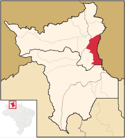 Location of Bonfim in the State of Roraima | |
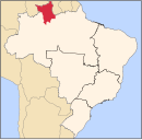
 Bonfim Location in Brazil | |
| Coordinates: 03°21′36″N 59°49′58″W | |
| Country | |
| Region | North |
| State | |
| Founded | 1 June 1982 |
| Government | |
| • Mayor | Joner Chagas (PRTB) |
| Area | |
| • Total | 8,095 km2 (3,125 sq mi) |
| Elevation | 92 m (302 ft) |
| Population (2020 [1]) | |
| • Total | 12,557 |
| • Density | 1.6/km2 (4.0/sq mi) |
| Time zone | UTC-4 |
| Demonym | bonfinense |
| Website | bonfim.rr.gov.br |
Overview
In 1775, the Portuguese built Fort São Joaquim at the confluence of the Uraricoera and the Takutu River to prevent the Dutch from advancing into the area.[4] The ruins of the fort can still be seen.[5] In 1790, the Amerindians revolted, and the Portuguese retreated from the region.[4]
Bonfim started with the compound of a religious mission from the United States.[5] On 1 July 1982 it became a municipality[5] by Federal Bill Nº 7.009. On 28 March 2007 it was declared a free port for international trade by President Luiz Inácio Lula da Silva.[6]

The municipality is home to Amerindians of the Wapishana and Macushi tribes who live in the Wapixana, Macuxi, and Jabuti Indigenous Territories. Many of the indigenous community are tri-lingual speaking their own language, Portuguese and English.[5]
The economy is mainly based on livestock in particular cattle ranching and agriculture which an emphasis on cassava, bananas and cashew.[5]
Transport
Bonfim is connected to the BR-401 which links the road network of Guyana to Boa Vista, the capital of Roraima, located 115 kilometres from Bonfim.[7]
References
- IBGE 2020
- "Bonfim". IBGE (in Portuguese). Retrieved 9 April 2021.
- Stabroek News at as of 16 March 2007
- "Macuxi". Socio Ambiental. Retrieved 9 April 2021.
- "Historia da Cidade". Government of Bonfim (in Portuguese). Retrieved 9 April 2021.
- "LEI Nº 11.732, DE 30 DE JUNHO DE 2008". Planalto.gov.br (in Portuguese). Retrieved 9 April 2021.
- Reinaldo Imbrozio Barbosa and Ciro Campos (2001). "Detection and geographical distribution of clearing areas in the savannas ('lavrado') of Roraima using Google Earth web tool". Journal of Geography and Regional Planning: 125. ISSN 2070-1845.
{{cite journal}}: CS1 maint: uses authors parameter (link)
External links
- Official site (in Portuguese)
 Media related to Bonfim (Roraima) at Wikimedia Commons
Capital: Boa Vista | ||
| Boa Vista |
|  |
| Nordeste de Roraima | ||
| Caracarai | ||
| Sudeste de Roraima | ||
На других языках
- [en] Bonfim, Roraima
[es] Bonfim (Roraima)
Bonfim es un municipio (10.951 habitantes) del estado brasileño de Roraima, siendo el quinto mayor en población según lo estimado al 2005 por el Instituto Brasileiro de Geografia e Estatística.[ru] Бонфин (Рорайма)
Бонфин (порт. Bonfim) — муниципалитет в Бразилии, входит в штат Рорайма. Составная часть мезорегиона Север штата Рорайма. Входит в экономико-статистический микрорегион Нордести-ди-Рорайма. Население составляет 10 943 человека на 2010 год. Занимает площадь 8 095,421 км². Плотность населения — 1,35 чел./км².Другой контент может иметь иную лицензию. Перед использованием материалов сайта WikiSort.org внимательно изучите правила лицензирования конкретных элементов наполнения сайта.
WikiSort.org - проект по пересортировке и дополнению контента Википедии