world.wikisort.org - Brazil
Rorainópolis (Portuguese pronunciation: [ʁoɾɐjˈnɔpuʎis]) is a municipality located in the southernmost point of the state of Roraima in Brazil. Its population is 30,782 (as of 2020) and its area is 33,594 km². The municipality is crossed by the equator.
Rorainópolis | |
|---|---|
Municipality | |
| The Municipality of Rorainópolis | |
 A street in Rorainópolis | |
 Flag  Seal | |
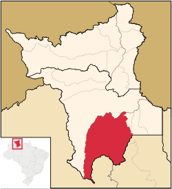 Location of Rorainópolis in the State of Roraima | |
| Coordinates: 00°56′45″N 60°25′04″W | |
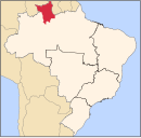
| Country | |
| Region | North |
| State | |
| Founded | 17 October 1995 |
| Government | |
| • Mayor | Leandro Pereira da Silva (PSD) |
| Area | |
| • Total | 33,594 km2 (12,971 sq mi) |
| Elevation | 98 m (322 ft) |
| Population (2020 [1]) | |
| • Total | 30,782 |
| • Density | 0.77/km2 (2.0/sq mi) |
| Time zone | UTC-4 |
| HDI (2000) | 0.676 – medium[2] |
| Website | www.rorainopolis.rr.gov.br |
History
In the 1970s, the regional headquarters of INCRA were established in Rorainópolis along the BR-174 highway. INCRA started to distribute land which attracted settlers from all of Brazil.[3] In 1988, the name was changed from Vila do Incra to Rorainópolis.[4] In 1995, Rorainópolis became an independent municipality, and has become the second most populous of the state of Roraima.[3] The State University of Roraima operates a campus at Roraima.[5]
Nature
The Anauá National Forest is a 259,400 hectares (641,000 acres) national forest in Rorainópolis.[6] It is a protected area with sustainable use of natural resources established in 2005.[7] The Baixo Rio Branco-Jauaperi Extractive Reserve is a 581,173 hectares (1,436,110 acres) protected area which has a shared use agreement with Waimiri Atroari Indigenous Territory.[8] It has been established in 2018.[9]
The nature in Rorainópolis is under threat from palm oil plantations. Palmaplan has as of 2021, bought 30,000 hectares of land. The cattle ranchers are eager to sell their land, and deforest new areas.[10]
Villages
- Santa Maria do Boiaçu
References
- IBGE 2020
- - UNDP
- "História de Rorainópolis". Municipality of Rorainópolis (in Portuguese). Retrieved 13 April 2021.
- "CEP - Rorainópolis". Senac (in Portuguese). Retrieved 13 April 2021.
- "CAMPUS RORAINÓPOLIS". Universidade Estadual de Roraima (in Portuguese). Retrieved 13 April 2021.
- "Floresta Nacional de Anauá". ICMBio - FLONA (in Portuguese). Retrieved 13 April 2021.
- "Floresta Nacional De Anauá". Protected Planet (in Portuguese). Retrieved 13 April 2021.
- "Reserva Extrativista Baixo Rio Branco-Jauaperi". Socio Ambiental. Retrieved 13 April 2021.
- "Reserva Extrativista Baixo Rio Branco Jauaperi". Protected Planet. Retrieved 13 April 2021.
- "New palm oil frontier sparks scramble for land in the Brazilian Amazon". Monga Bay. Retrieved 15 April 2021.
External links
- Official site (in Portuguese)
 Media related to Rorainópolis at Wikimedia Commons
Capital: Boa Vista | ||
| Boa Vista |
|  |
| Nordeste de Roraima |
| |
| Caracarai |
| |
| Sudeste de Roraima |
| |
| Authority control |
|
|---|
На других языках
- [en] Rorainópolis
[es] Rorainópolis
Rorainópolis es un municipio del sur del estado brasileño de Roraima, creado en 1995 con territorios que pertenecían a los municipios de São Luiz, donde se localiza la sede municipal, y São João da Baliza. Es el segundo mayor en población del estado.[ru] Рорайнополис
Рорайнополис (порт. Rorainópolis) — муниципалитет в Бразилии, входит в штат Рорайма. Составная часть мезорегиона Юг штата Рорайма. Входит в экономико-статистический микрорегион Судести-ди-Рорайма. Население составляет 24 279 человека на 2010 год. Занимает площадь 33 595,602 км². Плотность населения — 0,72 чел./км².Другой контент может иметь иную лицензию. Перед использованием материалов сайта WikiSort.org внимательно изучите правила лицензирования конкретных элементов наполнения сайта.
WikiSort.org - проект по пересортировке и дополнению контента Википедии