world.wikisort.org - Brazil
Uiramutã (Portuguese pronunciation: [wiɾamuˈtɐ̃]) is a municipality located in the northeast of the state of Roraima in Brazil. Its population is 10,789 (as of 2020) and its area is 8,066 km2. It is the northernmost municipality of Brazil, with Monte Caburaí being the northernmost point. West of this mountain, there is also the Monte Roraima, the tallest mountain in Roraima and in Guyana, located in the triple frontier of Brazil, Guyana and Venezuela. Still, Uiramutã holds the title of the northernmost urban seat of a municipality in Brazil. Its counterparts in the South, West and East are respectively Chuí, state of Rio Grande do Sul; Mâncio Lima, Acre; and João Pessoa, Paraíba.
Uiramutã | |
|---|---|
Municipality | |
| Município de Uiramutã | |
 Marker on the Brasil-Venezuela-Guiana border, Monte Guyana | |
 Flag  Seal | |
| Motto(s): O Brasil começa aqui (Brazil starts here) | |
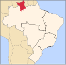
 Location of Uiramutã in the State of Roraima | |
 Uiramutã Location in Brazil | |
| Coordinates: 04°35′45″N 60°10′04″W | |
| Country | |
| Region | North |
| State | |
| Founded | October 17, 1995 |
| Government | |
| • Mayor | Manuel da Silva Araujo (PP) |
| Area | |
| • Total | 8,066 km2 (3,114 sq mi) |
| Elevation | 804 m (2,638 ft) |
| Population (2020 [1]) | |
| • Total | 10,789 |
| • Density | 0.87/km2 (2.3/sq mi) |
| Time zone | UTC-4 |
| HDI (2000) | 0.542 – medium[2] |
| Website | uiramuta.rr.gov.br |
The municipality is located entirely inside the Raposa Serra do Sol Indian Reservation. Because of this, its economic activities are limited. As a result, Uiramutã is also noted for being the Brazilian municipality that depends the most on government funds: 80% of its income is provided by the public administration, including social insurance and welfare programs such as the Bolsa Família.[3]
The town of Uiramutã was established in 1911 by Severino Pereira da Silva, a gold miner, who founded the village for both the indigenous and non-indigenous community.[4] Uiramutã became an independent municipality in 1995,[5] and can be accessed via the RR-171 road.[4]
Nature
The municipality contains the 116,748 hectares (288,490 acres) Monte Roraima National Park, a protected area created in 1989.[6]
References
- IBGE 2020
- - UNDP
- Patu, Gustavo (19 December 2013). "Em Uiramutã, no extremo norte do país, governo responde por 80% da economia". Folha de S. Paulo (in Portuguese). Grupo Folha. Retrieved 19 December 2013.
- "RR – Terra Indígena Raposa Serra do Sol". Eco Amazonia (in Portuguese). Retrieved 10 April 2021.
- "Uiramutã". IBGE (in Portuguese). Retrieved 10 April 2021.
- Unidade de Conservação: Parque Nacional do Monte Roraima (in Portuguese), MMA: Ministério do Meio Ambiente, retrieved 2016-06-07
External links
- Official website (in Portuguese)
 Media related to Uiramutã at Wikimedia Commons
Capital: Boa Vista | ||
| Boa Vista |
|  |
| Nordeste de Roraima | ||
| Caracarai | ||
| Sudeste de Roraima | ||
 | This Roraima, Brazil location article is a stub. You can help Wikipedia by expanding it. |
На других языках
- [en] Uiramutã
[es] Uiramutã
Uiramutã es un municipio del nordeste del estado de Roraima, siendo el municipio más septentrional del Brasil. Uiramutã Esporte Clube[ru] Уйрамутан
Уйрамутан (порт. Uiramutã) — муниципалитет в Бразилии, входит в штат Рорайма. Составная часть мезорегиона Север штата Рорайма. Входит в экономико-статистический микрорегион Нордести-ди-Рорайма. Население составляет 8 375 человек на 2010 год. Занимает площадь 8 065,564 км². Плотность населения — 1,04 чел./км².Другой контент может иметь иную лицензию. Перед использованием материалов сайта WikiSort.org внимательно изучите правила лицензирования конкретных элементов наполнения сайта.
WikiSort.org - проект по пересортировке и дополнению контента Википедии