world.wikisort.org - Brazil
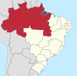
The North Region of Brazil (Portuguese: Região Norte do Brasil; [ʁeʒiˈɐ̃w̃ ˈnɔʁtʃi du bɾaˈziw]) is the largest region of Brazil, corresponding to 45.27% of the national territory. It is the second least inhabited of the country, and contributes with a minor percentage in the national GDP and population. It comprises the states of Acre, Amapá, Amazonas, Pará, Rondônia, Roraima and Tocantins.
North Region
Região Norte | |
|---|---|
Region | |
 | |
| Coordinates: 3°7′45″S 60°1′17″W | |
| Country | |
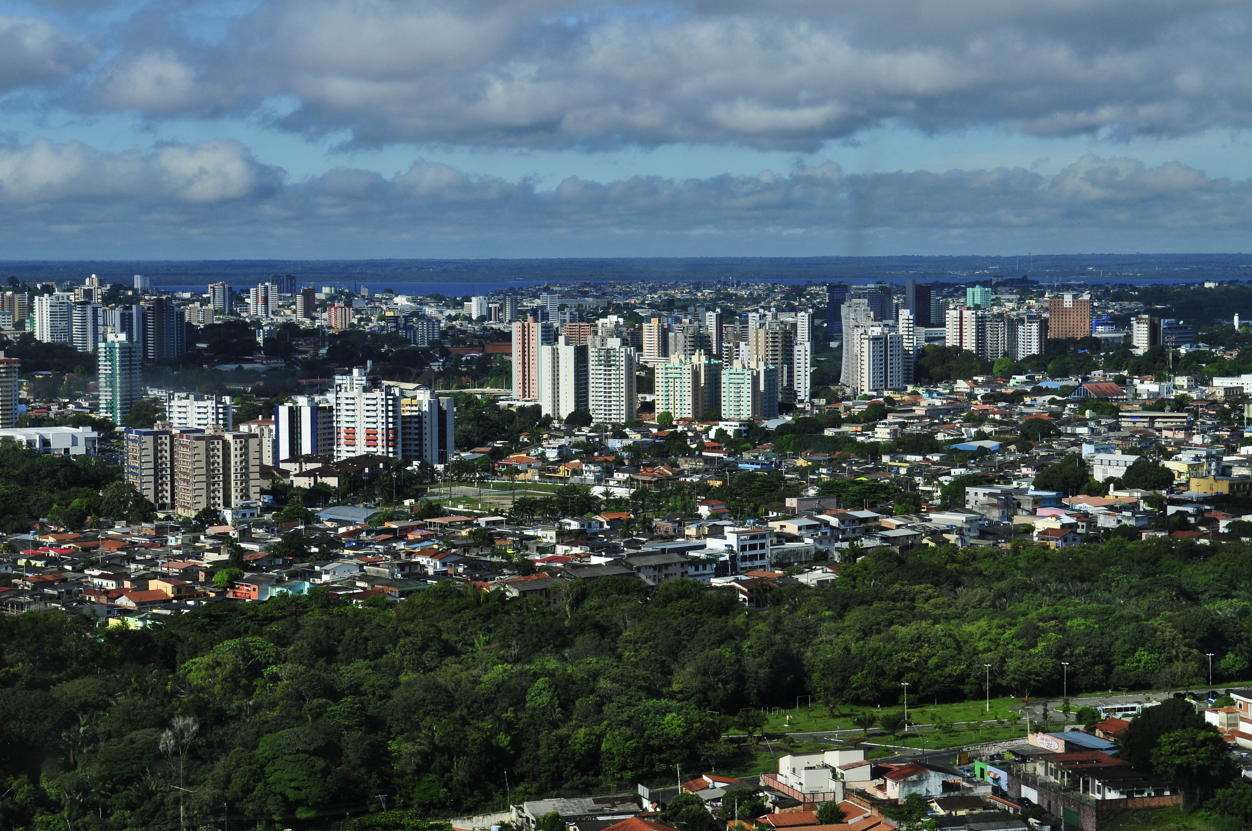
| Largest cities | Manaus Belém |
| States | Acre, Amapá, Amazonas, Pará, Rondônia, Roraima and Tocantins |
| Area | |
| • Region | 3,853,676.9 km2 (1,487,913.0 sq mi) |
| • Rank | 1st |
| Population | |
| • Region | 18,672,591 |
| • Rank | 4th |
| • Density | 4.8/km2 (13/sq mi) |
| • Rank | 5th |
| • Urban | 75.6% |
| GDP | |
| • Year | 2014 |
| • Total | R$387,5 billion (5th) |
| • Per capita | R$17,879 (4th) |
| HDI | |
| • Year | 2014 |
| • Category | 0.730 – high (4th) |
| • Life expectancy | 71 years (4th) |
| • Infant mortality | 25.8 per 1,000 (2nd) |
| • Literacy | 88.7% (4th) |
| Time zones | UTC−3 (BRT) |
| UTC−4 (AMT) | |
| UTC−5 (ACT) | |
Its demographic density is the lowest in Brazil considering all the regions of the country, with only 3.8 inhabitants per km2. Most of the population is centered in urban areas.
Belém International Airport and Manaus International Airport connect the North Region with many Brazilian cities and also operate some international flights.
The North is home to the Federal University of Amazonas and Federal University of Pará, among others.
History
The first inhabitants of the North Region, as in the rest of Brazil, were the Native Brazilians, who shared a diverse number of tribes and villages, from the pre-Columbian period until the arrival of the European people.[1]
The Spaniards, among them Francisco de Orellana, organized exploratory expeditions by the Amazon river to know the region. After long journeys alongside Francisco de Orellana, Gonzalo Fernández de Oviedo y Valdés wrote a letter addressed to Cardinal Pedro Bembo in Venice, extolling the fauna and flora existing in the region at the time of the expedition.[1]
The 17th century marked the arrival of the Portuguese people, where they built military strongholds to defend the region against the invasion of other peoples, in 1616, causing in the foundation of Belém do Pará. The richness of the Amazon Rainforest has also become interesting for the Portuguese Crown.[1] With the Portuguese explorers, the Catholic missionaries came to the region, in order to catechize the natives. The natives were assembled by missionaries in villages, called missions, many of which gave birth to several cities, such as Borba and Óbidos.[1]
Some of the Region's oldest towns: Bragança, Xapuri, Tefé, Natividade and Amapá.[2] In order to work on rubber extraction, Brazilians from other states, mainly from the Northeast Region, moved to the region. Also many Japanese families came to work in the agricultural colonies.
During the 1960s, 1970s and 1980s, military governments implemented a major plan to integrate the region with other regions of Brazil, including the construction of several highways (such as the Trans-Amazonian Highway), the installation of industries and the creation of the Free Economic Zone of Manaus.
Settlement

The territorial division into countries does not necessarily coincide with the indigenous occupation of the geographical space; in many cases, there are people living on both sides of international borders, which were created long after they were already in the region.
From the beginning of the colonization from the 17th century to the present day, the inhabitants of Amazônia dedicated themselves to extractive and mercantilist activities, inserting between 1840 and 1910 the monopoly of rubber, mainly in Amazonas and Acre. All this process of colonization has brought about changes such as the reduction of the indigenous population, the increase of the Caboclo identity, the mixing of whites, blacks and indigenous people, the reduction of species of plants and animals and other consequences.
After World War II, the Brazilian Amazon became part of the national development process. The creation of the National Institute of Amazonian Research (INPA) in 1952, the establishment of regional development agencies such as the Superintendency of Development for the Amazon (SUDAM) in 1966 and the Free Economic Zone of Manaus in 1967 began to contribute to the settlement of region and in the execution of projects focused on the region.
Geography
![Climate classification for Northern Brazil.[3]](http://upload.wikimedia.org/wikipedia/commons/thumb/4/46/North_Region%2C_Brazil_%28K%C3%B6ppen%29.svg/270px-North_Region%2C_Brazil_%28K%C3%B6ppen%29.svg.png)
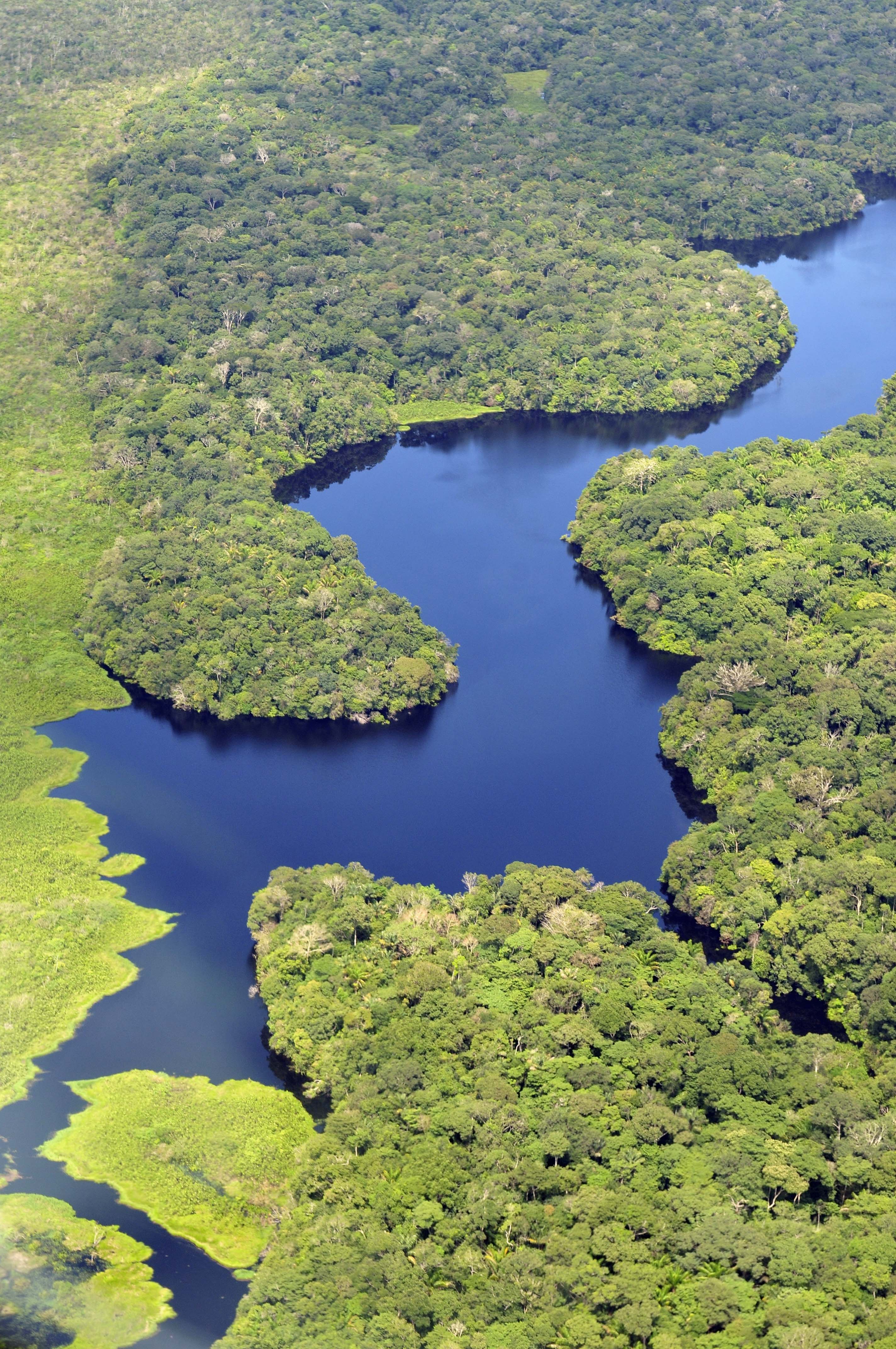
The Amazon represents over half of the planet's remaining rainforests and comprises the largest and most species-rich tract of tropical rainforest in the world. Wet tropical forests are the most species-rich biome, and tropical forests in the Americas are consistently more species rich than the wet forests in Africa and Asia.[4] As the largest tract of tropical rainforest in the Americas, the Amazonian rainforests have unparalleled biodiversity. More than 1/3 of all species in the world live in the Amazon Rainforest.[5] The region is home to about 2.5 million insect species, tens of thousands of plants, and some 2000 birds and mammals species. To date, at least 40,000 plant species, 3,000 fish, 1,294 birds, 427 mammals, 428 amphibians, and 378 reptiles have been scientifically classified in the region.[6] Scientists have described between 96,660 and 128,843 invertebrate species in Brazil alone.[7]
The diversity of plant species is the highest on earth with some experts estimating that one square kilometre may contain over 75,000 types of trees and 150,000 species of higher plants. One square kilometre of Amazon rainforest can contain about 90,790 tonnes of living plants.[8] This constitutes the largest collection of living plants and animal species in the world. One in five of all the birds in the world live in the rainforests of the Amazon. To date, an estimated 438,000 species of plants of economic and social interest have been registered in the region with many more remaining to be discovered or catalogued.[9]
Climate
Some latitudes can create a region with hot and humid climates. The existence of heat and the enormous liquid mass favor evaporation and make the region a very humid area.
Dominated by an equatorial climate, the region presents high temperatures throughout the year (averages from 24 °C to 26 °C), a low thermal amplitude, with the exception of some areas of the states of Amazonas, Rondônia and Acre, where the phenomenon of "friagem" occurs, due to La Niña's activity, allowing cold air masses coming from the South Atlantic Ocean to penetrate the states of the South Region of the country, pass through the Central-West region and reach the Amazonian states, causing rapidly falling temperature.
The Amazonian heat provides an area of low latitude that attracts masses of polar air. Occurring in winter, the effect of "friagem" lasts a week or so.
Political Subdivisions
| City | Population (2016) |
|---|---|
| Manaus | 2,094,391 |
| Belém | 1,446,042 |
| Porto Velho | 511,219 |
| Ananindeua | 510,834 |
| Macapá | 465,495 |
| Rio Branco | 377,057 |
| Boa Vista | 326,419 |
| Palmas | 279,856 |
Culture


With its own folklore, the main attractions are the Parintins Folklore Festival, Círio de Nazaré in Belém, Rio Branco and Macapá; Sairé Festival, in Santarém, ExpoAcre (the largest in the North region)[10][11] and typical dances, Marujada, Carimbó, Brazilian Calypso, Tecno brega and Cirandas such as Samba lelê and others.
In the region, there are some of the most beautiful theaters and palaces in Brazil: The Amazon Theatre, located in Manaus, Palácio Rio Branco, in Rio Branco, Palácio Senador Hélio Campos, in Boa Vista, Teatro das Bacabeiras, in Macapá and the Peace Theatre, located in Belém. The gastronomic culture of the northern region of Brazil is quite rich, has Indigenous, African and Portuguese roots, in addition to other influences from both within Brazil and other cultures outside the country, the strong Amazonian indigenous influence in its main dishes is remarkable, among the main highlights are delicacies such as duck in tucupi sauce, maniçoba, tacacá and a menu of a wide variety of species of Amazonian fish, such as pirarucu, tambaqui, jaú, piramutaba, among other species; a huge menu of fruits, such as the local açaí, pupunha, tucumã, cupuaçu, buriti, abiu, urucu, Malay apple, cumaru, guaraná, and ingá, among other fruits. The whole region has a rich variety of ingredients, but also foods based on cassava such as water flour, uarini flour, tapioca flour, tapioca gum, tucupi, among others.
Ethnic groups
The population of northern Brazil is largely made up of Caboclos, descendants of Native Brazilians and Europeans - mostly Portuguese, French and Spanish.
North of Brazil has received and continues to receive large migration of people from South and Southeast regions of the country. In the 20th century, also received great migration from the Northeast, who were working in the rubber plantations of Amazonas and Acre.
| Skin color/Race (2010)[12] | |
|---|---|
| Multiracial | 67.2% |
| White | 23.2% |
| Black | 6.5% |
| Amerindian | 1.9% |
| Asian | 1.1% |
Economy


The economy of the North Region is essentially based on the vegetal plantation and extraction, such as latex, açaí, woods and Brazil nuts; and mineral extraction of gold, precious stones, cassiterite and tin (metal); as well as mining exploitation, mainly iron, at Carajás Mountain Range (in the State of Pará) and manganese, at Navio Mountain Range (in the State of Amapá). Small-scale Buffalo creation and the Free Economic Zone of Manaus are also important to the local economy.
Infrastructure
Vehicles: 1,746,501 (March/2007); Telephones: 1,805,000 (April/2007); Cities: 449 (2007).
Portuguese language is the official national language, and thus the primary language taught in schools. However, English and Spanish are also part of the official high school curriculum.
Educational Institutions
- Federal University of Pará (UFPA)
- Federal University of Western Pará (UFOPA)
- Federal University of Southern and Southeastern Pará (UNIFESSPA)
- Pará State University (UEPA)
- Federal University of Acre (UFAC)
- Federal University of Amazonas (UFAM)
- Amazonas State University (UEA)
- University of Amazon (UNAMA)
- Federal University of Rondônia (UNIR)
- Federal University of Tocantins (UFT)
- Federal University of Amapá (UNIFAP)
- Federal University of Roraima (UFRR)
Transportation
There are only a few highways in the North region. The most important ones are the Trans-Amazonian highway, running through Amazonas, Pará, Piauí, Maranhão, Rodovia Belém-Brasília, Federal District, Goiás, Tocantins, Maranhão.
Most of the transportation on the region is done by boat or airplane, mainly in the state of Amazonas. There are two major airports in the region: Belém International Airport, serving Belém, and Eduardo Gomes International Airport, serving Manaus.
See also
- Amazônia Legal
- Ecotourism
References
- "História da Região Norte do Brasil". Hjo Brasil. Archived from the original on 6 June 2013. Retrieved 28 May 2013.
- "Página - IPHAN - Instituto do Patrimônio Histórico e Artístico Nacional".
- Alvares, C. A.; Stape, J. L.; Sentelhas, P. C.; de Moraes, G.; Leonardo, J.; Sparovek, G. (2013). "Köppen's climate classification map for Brazil". Meteorologische Zeitschrift. 22 (6): 711–728. Bibcode:2013MetZe..22..711A. doi:10.1127/0941-2948/2013/0507.
- Turner, I.M. 2001. The ecology of trees in the tropical rain forest. Cambridge University Press, Cambridge. ISBN 0-521-80183-4
- "Amazon Rainforest, Amazon Plants, Amazon River Animals". World Wide Fund for Nature. Retrieved 2007-11-26.
- Da Silva et al. 2005. "The Fate of the Amazonian Areas of Endemism". Conservation Biology 19 (3), 689-694
- Lewinsohn, Thomas M.; Paulo Inácio Prado (June 2005). "How Many Species Are There in Brazil?". Conservation Biology. 19 (3): 619–624. doi:10.1111/j.1523-1739.2005.00680.x. S2CID 84691981.
- Photos / Pictures of the Amazon Rainforest
- The Amazon Rainforest Archived 2008-08-12 at the Wayback Machine
- "Peruvian businessmen close deals worth US$5.8 million at Brazil Expoacre 2015".
- "In Rio Branco, the 46th ExpoAcre brings together more than 100 zebus on the track".
- "Tabela 2094: População residente por cor ou raça e religião".
Другой контент может иметь иную лицензию. Перед использованием материалов сайта WikiSort.org внимательно изучите правила лицензирования конкретных элементов наполнения сайта.
WikiSort.org - проект по пересортировке и дополнению контента Википедии