world.wikisort.org - Brazil
Amapá ([ɐmɐˈpa] (![]() listen)) is a municipality located in the easternmost portion of the homonymous state of Amapá in Brazil. Its population is 9,187 and its area is 9,169 square kilometres (3,540 sq mi).
listen)) is a municipality located in the easternmost portion of the homonymous state of Amapá in Brazil. Its population is 9,187 and its area is 9,169 square kilometres (3,540 sq mi).
Amapá | |
|---|---|
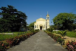
 Church of Amapá | |
 Location of Amapá in Amapá State | |
 Amapá Location in Brazil | |
| Coordinates: 02°03′10″N 50°47′34″W | |
| Country | |
| Region | North |
| State | Amapá |
| Government | |
| • Mayor | Carlos Sampaio (PMN) |
| Area | |
| • Total | 9,169 km2 (3,540 sq mi) |
| Elevation | 8 m (26 ft) |
| Population (2020)[1] | |
| • Total | 9,187 |
| • Density | 0.808/km2 (2.09/sq mi) |
| Time zone | UTC−3 (BRT) |
| HDI (2000) | 0.72 – medium[2] |
History
The borders between French Guiana and Brazil were not clear. Attempts at negotiations failed, and in 1862 it was decided that the area between the Amazon and the Oyapock was a neutral territory.[3] In 1894 gold was discovered in the Calçoene River, which resulted in a declaration of an autonomous state under Brazilian protection by general Francisco Cabral.[3] In May 1895, Camille Charvein, the Governor of French Guiana, sent troops to Mapá (nowadays: Amapá). During the battle, six French, and 30 Brazilian soldiers and civilians were killed .[4] In 1897, France and Brazil asked Switzerland to settle the dispute, and most of the territory was given to Brazil in what is nowadays the state of Amapá.[3]
The municipality was founded in 1911 as Montenegro. In 1930, the name was changed to Amapá after the Amapá tree. The municipality contains two districts: the town of Amapá and Sucuriju.[5] The municipality is home to a World War II airbase built by the Americans which has been turned into a museum.[6]
Nature

The municipality is home to part of the Lago Piratuba Biological Reserve.[7] It also contains the Maracá-Jipioca Ecological Station, which covers two very low-lying islands just off the coast with rich biodiversity.[8] It contains 6.32% of the 2,369,400 hectares (5,855,000 acres) Amapá State Forest, a sustainable use conservation unit established in 2006.[9] It contains 3.08% of the 460,353 hectares (1,137,560 acres) Amapá National Forest, a sustainable use conservation unit created in 1989.[10]
From Amapá you can access Cachoeira Grande, a series of waterfalls in the Amapá Grande River. The site is technically located in the Calçoene municipality.[6] Near the falls, is a sandbank and a holiday resort with restaurants.[11]
See also
- Sucuriju, fishing village and district of Amapá
References
- IBGE 2020
- "Archived copy". Archived from the original on 2009-10-03. Retrieved 2009-12-17.
{{cite web}}: CS1 maint: archived copy as title (link) UNDP - Denis Lamaison. "The Republic of Counani: The man who would be king". Guianas Geographic. Retrieved 5 August 2020.
- Stéphane Granger (2011). "Le Contesté franco-brésilien : enjeux et conséquences d'un conflit oublié entre la France et le Brésil". Outre-Mers. Revue d'histoire (in French): 162–163.
- "História". IBGE (in Portuguese). Retrieved 31 March 2021.
- "Amapá". Municipality of Amapá (in Portuguese). Retrieved 31 March 2021.
- Unidade de Conservação: Reserva Biológica do Lago Piratuba, MMA: Ministério do Meio Ambiente, retrieved 2016-04-27
- Unidade de Conservação: Estação ecológica de Maracá-Jipioca (in Portuguese), MMA: Ministério do Meio Ambiente, retrieved 2016-04-16
- FES do Amapá (in Portuguese), ISA: Instituto Socioambiental, retrieved 2016-07-06
- FLONA do Amapá (in Portuguese), ISA: Instituto Socioambiental, retrieved 2016-07-06
- "CACHOEIRA GRANDE EM AMAPÁ – AP". Viaja Brasil (in Portuguese). Retrieved 1 April 2021.
External links
- Official site (in Portuguese)
На других языках
[de] Amapá (Stadt)
Amapá, amtlich Município de Amapá, ist eine Kleinstadt im brasilianischen Bundesstaat Amapá in der Região Norte. Sie liegt am Atlantischen Ozean und ist rund 302 km von der Hauptstadt Macapá entfernt. Die Bevölkerungszahl wurde zum 1. Juli 2019[1] auf 9109 Einwohner geschätzt. Die Einwohner, die auf dem etwa 9167,6 km² großen Gebiet leben, werden Amapaenser (portugiesisch amapaenses) genannt. Die Bevölkerungsdichte lag 2010 unter einer Personen (0,8) pro km².[1]- [en] Amapá (municipality)
[ru] Амапа (муниципалитет)
Амапа́ (порт. Amapá) — муниципалитет в бразильском штате Амапа. Входит в экономико-статистический микрорегион Амапа, который является частью мезорегиона Север штата Амапа. Население составляет 8 069 человека на 2010 год. Занимает площадь 9 167,617 км². Плотность населения — 0,88 чел./км².Другой контент может иметь иную лицензию. Перед использованием материалов сайта WikiSort.org внимательно изучите правила лицензирования конкретных элементов наполнения сайта.
WikiSort.org - проект по пересортировке и дополнению контента Википедии


