world.wikisort.org - Brazil
Amapá ([amaˈpa] (![]() listen)) is one of the 26 states of Brazil. It is in the northern region of Brazil. It is the second least populous state and the eighteenth largest by area. Located in the far northern part of the country, Amapá is bordered clockwise by French Guiana to the north, the Atlantic Ocean to the east, Pará to the south and west, and Suriname to the northwest. The capital and largest city is Macapá. The state has 0.4% of the Brazilian population and is responsible for only 0.22% of the Brazilian GDP.
listen)) is one of the 26 states of Brazil. It is in the northern region of Brazil. It is the second least populous state and the eighteenth largest by area. Located in the far northern part of the country, Amapá is bordered clockwise by French Guiana to the north, the Atlantic Ocean to the east, Pará to the south and west, and Suriname to the northwest. The capital and largest city is Macapá. The state has 0.4% of the Brazilian population and is responsible for only 0.22% of the Brazilian GDP.
Amapá | |
|---|---|
State | |
| State of Amapá Estado do Amapá (Portuguese) | |
 Flag  Coat of arms | |
| Anthem: Hino do Amapá | |
 | |
| Coordinates: 1°N 52°W | |
| Country | |
| Founded | 1 January 1991 |
| Capital and largest city | Macapá |
| Government | |
| • Governor | Waldez Góes (PDT) |
| • Vice Governor | Jaime Nunes (PSD) |
| • Senators | Davi Alcolumbre (UNIÃO) Lucas Barreto (PSD) Randolfe Rodrigues (REDE) |
| Area | |
| • Total | 142,814.585 km2 (55,141.020 sq mi) |
| • Rank | 18th |
| Highest elevation (Massif du Mitaraka) | 681 m (2,234 ft) |
| Population (2007)[1] | |
| • Total | 669,526 |
| • Estimate (2019) | 845,731 |
| • Rank | 26th |
| • Density | 4.7/km2 (12/sq mi) |
| • Rank | 23rd |
| Demonym | Amapáense |
| GDP | |
| • Year | 2012 |
| • Total | R$ 10,420,000,000 (25th) |
| • Per capita | R$ 14,915.00 (15th) |
| HDI | |
| • Year | 2017 |
| • Category | 0.740[2] – high (13th) |
| Time zone | UTC−3 (BRT) |
| Postal Code | 68900-000 to 68999-000 |
| ISO 3166 code | BR-AP |
| License Plate Letter Sequence | NEI to NFB, QLN to QLT, SAK to SAO |
| Website | ap.gov.br |
In the colonial period the region was called Portuguese Guiana and was part of Portugal's State of Brazil. Later, the region was distinguished from the other Guianas. Amapá was once part of Pará, but became a separate territory in 1943, and a state in 1990.[3]
The dominant feature of the region, and 90 percent of its total area, is the Amazon Rainforest. Unexplored forests occupy 70 percent of Amapá, and Tumucumaque Mountains National Park, established in 2002, is the largest tropical forest park in the world. The estuary of the River Oiapoque is the northernmost point of coastal Brazil.
History
During the colonial era from 1637 to 1654 the Amapá region was merged into the Captaincy of Pará, this was the Captaincy of Cabo de Norte.[4] In the early colonial period the Amapá region was a rich source of lumber, resins, annatto, vegetable oils, and salted fish, all of which were exported to Europe. The French established sugarcane plantations in this period.

With the discovery of mineral deposits the Amapá region was invaded by the English and Dutch, who were ultimately repelled by the Portuguese.[4] The Treaty of Utrecht in 1713 established the boundaries between the colony of Brazil and French Guiana, but these were not respected by the French. A fort was constructed at São José de Macapá, in present-day Macapá, as a base of Portuguese power in the region.[4] In the 18th century, France retook control of the area. This international dispute continued until 1900.
With the discovery of gold and the increasing value of rubber on the international market during the 19th century, outsider population increased in Amapá and the territorial dispute with France was brought to a head. French settlers established the State of Counani (1886–1891). The gold rush however brought in Brazilian interests who gained control of the territory, which led to clashes with the French. The dispute was sent for arbitration and on 1 December 1900, the Arbitration Commission of Geneva awarded possession of the territory to Brazil. It was incorporated into the state of Pará, with the joint name of Araguari (named for the river of the same name). It became the federal territory of Amapá in 1943.
The discovery of rich manganese deposits in Serra do Navio in 1945 revolutionized the local economy. Manganese remains the largest source of revenue in the state.[4] Amapá did not achieve statehood until 5 October 1988, at the time of the promulgation of the new Brazilian Constitution.
Geography
 Amapá National Forest
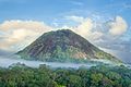 Karupina mountain in the Uaçá Indigenous Territory, Amapá, Brazil.


The State of Amapá possesses the lowest rate of loss of its original vegetation for any Brazilian state, estimated at only 2%. Most of the Amapá territory is covered with rainforest, while the remaining areas are covered with savannah and plains. On the Amapá coast, almost intact beaches mix with swamps, creating the largest representation of this biome in Brazil. This mixture of salt and fresh water is perfect for the food chain reproduction for several animal species. Pollution, however, is now a chronic problem in the state of Amapá. Mercury, which is used in the extraction of gold, is widely found in water sources and sewage systems in the population centers of Amapá.[4]
Nature
To protect the natural resources of the state, there are, as of 2016, 12 protected areas and five indigenous territories covering 10,476,117 hectares (25,887,050 acres), or 72% of the state.[5] The Amapá Biodiversity Corridor has been established in 2003 to provide integrated management for conservation area.[6] The most important protected areas are the Tumucumaque Mountains National Park located in west of the state, and the Cabo Orange National Park located near the coast. The Tumucumaque Mountains National Park is the world's largest tropical forest national park.[7] The Cabo Orange National Park contains flooded grasslands and mangrove forests which are important fish nurseries.[8]
Climate

Most of Amapá has a Tropical monsoon climate, a tropical climate with a short dry season and heavy rainfall for the majority of the year. In the Köppen climate classification, it is classified under the letters Am. Tropical rainforest is the natural vegetation, and also provides the other climate type located in the state.
Demographics
According to the IBGE of 2010, there were 668,689 people residing in the state, with a population density of 4.3/km². The population of Amapá is highly urbanized, with 93.7% of the population residing primarily in Macapá and Santana.[9] Population growth: 5.7% (1991–2000); Houses: 144,000 (2006).
During the 2010 census, 65% identified as Pardo (multiracial), 24% as White Brazilians, 8.7% as Black Brazilians and 1.1% as Indigenous. The remaining 1.2% are Asians and undeclared.[10]
The majority of the residents of Amapá live in poverty. According to the Fundação Getulio Vargas (FGV) 36.56% of the population live on only R$79 per month, which the foundation considers below a decent standard of living.[4]
Municipalities
Largest cities or towns in Amapá (2010 census by the Brazilian Institute of Geography and Statistics)[11] | |||||||||
|---|---|---|---|---|---|---|---|---|---|
| Rank | Mesoregion | Pop. | Rank | Mesoregion | Pop. | ||||
 Macapá  Santana |
1 | Macapá | Sul | 407,023 | 11 | Amapá | Norte | 8,142 |  Laranjal do Jari  Oiapoque |
| 2 | Santana | Sul | 102,860 | 12 | Ferreira Gomes | Sul | 5,974 | ||
| 3 | Laranjal do Jari | Sul | 40,819 | 13 | Cutias | Sul | 4,805 | ||
| 4 | Oiapoque | Norte | 21,094 | 14 | Serra do Navio | Sul | 4,463 | ||
| 5 | Mazagão | Sul | 17,419 | 15 | Itaubal | Sul | 4,370 | ||
| 6 | Porto Grande | Sul | 17,252 | 16 | Pracuuba | Norte | 3,909 | ||
| 7 | Tartarugalzinho | Norte | 12,981 | ||||||
| 8 | Vitória do Jari | Sul | 12,725 | ||||||
| 9 | Pedra Branca do Amapari | Sul | 11,291 | ||||||
| 10 | Calçoene | Norte | 9,174 | ||||||
Indigenous population

The Amerindians tribes in Amapá are located in the north near the Oiapoque River, and in the east in the Wayampi Indigenous Territory. All the indigenous territories in Amapá have been demarcated. The tribes living in Amapá are the Galibi do Oiapoque, the Karipuna do Amapá, the Palikur, the Wayampi and the Galibi Marwono.[12]
The region around the Amazon River used to support a large population of Amerindians during the pre-Columbian era.[13] The policy of the Portuguese monarchy was to engage in war in order to clear them from the land.[14] The Cabanagem Revolt in the 1830s, resulted in the final dispersal of the Amerindians along the Amazon.[15]
Education
Portuguese is the official national language, and thus the primary language taught in schools. French is the second language taught in every school due to the proximity of French Guiana. A creole language called Lanc-Patuá is spoken among some of the people.
Educational institutions
- Universidade Federal do Amapá (Unifap) (Federal University of Amapá)
- Universidade Estadual do Amapá (UEAP) (Amapá State University)
- Instituto Federal de Educação, Ciência e Tecnologia do Amapá (IFAP) (Amapá Federal Institute of Education, Science and Technology)
- Centro de Ensino Superior do Amapá (Ceap)
- Instituto de Ensino Superior do Amapá (Iesap)
- Instituto Macapaense de Ensino Superior (IMMES)
- Faculdade Seama (Seama College)
Economy
The service sector is the largest component of GDP at 87.6%, followed by the industrial sector at 7.8%. Agriculture represents 4.6% of GDP (2004). Amapá exports: wood 75.5%, ores 18.7%, heart of palm 5.5% (2002). The state, which has 0.4% of the Brazilian population, is responsible for only 0.22% of the Brazilian GDP.[16][17][18][19]
Transport

International Airport
The main airport of the state is Macapá International Airport. On 12 April 2019 a new terminal was opened replacing an older facility. Following its closure, the old terminal was demolished to make room for an enlarged apron which was completed by 2020.[20][21]
Highways
There are two federal highways in Amapá: BR-156 connects Laranjal do Jari, Macapá and Oiapoque.[22] The highway is connected to the road network of French Guiana via the Oyapock River Bridge.[23] BR-210 connects Macapá with Serra do Navio.[24] It is supposed to be extended all the way to the border with Colombia in Amazonas, however as of 2021, it ends in the Wayampi Indigenous Territory.[25] An important state road is the AP-010 which connects Macapá with Santana and Mazagão Velho.[26]
There are no road connections to other Brazilian states. In Laranjal do Jari there is a ferry to Monte Dourado in Pará.[27] In Port Santana, there is a ferry to Belém, Pará.[28]
Ports and harbours
There is a small port in Macapá, however it is not suitable for cargo traffic.[29] The main harbour is the Port of Santana which is also used for international cargo.[30]
Flag
The flag was adopted by Decree No. 8 of 23 April 1984. The blue represents the sky over Amapá and justice, the green represents the native rainforest, and the yellow represents the Union and its natural resources. The black stands for the deceased who worked for the state, and the white for the will of the state to live in peace and stability. The symbol on the hoist-side represents the Fortress of São José, out of which the state capital grew.[31]
Before 1984, the state had a red-white-red flag, based on the flag of Pará, and similar to the flag of Peru.[32]
See also
- Brazil
- Calçoene - Amapá town, site of pre-colonial observatory
References
- "2014 Brazilian Population Estimates" (PDF). IBGE. Retrieved 29 March 2015.
- "Radar IDHM: evolução do IDHM e de seus índices componentes no período de 2012 a 2017" (PDF) (in Portuguese). PNUD Brasil. Retrieved 18 April 2019.
- "Amapá". Encyclopædia Britannica. Encyclopædia Britannica Inc. 2015. Retrieved 2 February 2015.
- Presser, Margaret (2006). Pequeña enciclopédia para descobrir o Brasil. Rio de Janeiro: Editora Senac Rio. pp. 26–29. ISBN 8587864742.
- Tamburelli, Gianfranco (2008). Legal Systems for the Management of Protected Areas in Italy and Ukraine: The Experiences of the Lazio and Kyiv Regions. Giuffrè Editore. p. 40. ISBN 978-88-14-14368-7. Retrieved 5 April 2021.
- Corredor de Biodiversidade do Amapá Biodiversity Corridor (PDF). Belém: CI-Brasil, Governo do Amapá, Fundação Lee & Gund. 2007. Retrieved 5 April 2021.
- "Brazil creates largest rainforest reserve". BBC News. 5 April 2021. Retrieved 23 August 2015.
- "Cabo Orange National Park". Ramsar. Retrieved 5 April 2021.
- "Perfil do Estado" (in Portuguese). Macapá: Governo do Estado do Amapá. 2015. Archived from the original on 2 February 2015. Retrieved 2 February 2015.
- "Censo Demográfico" (PDF). IBGE (in Portuguese). Retrieved 6 April 2021.
- "Estimativas da população residente nos municípios brasileiros com data de referência em 1º de julho de 2011" [Estimates of the Resident Population of Brazilian Municipalities as of July 1, 2011] (PDF) (in Portuguese). Brazilian Institute of Geography and Statistics. 30 August 2011. Retrieved 31 August 2011.
- "Índios do Amapá". Terras Indigenas (in Portuguese). Retrieved 6 April 2021.
- Charles R. Clement (2015). "4". The domestication of Amazonia before European conquest. Proceedings of the Royal Society B: Biological Sciences. Vol. 282. The Royal Society Publishing. doi:10.1098/rspb.2015.0813. PMC 4528512. PMID 26202998.
- Mark Harris and Silvia Espelt-Bombin (2018). "Rethinking Amerindian Spaces in Brazilian History". Ethnohistory. 65 (4): 537–547. doi:10.1215/00141801-6991187.
- Anonby, Stan (2007). "A report on the creoles of Amapá". Journal of Language Survey Reports: 7.
- Camargo, Sophia (15 December 2019). "Descubra quais são os 15 Estados mais ricos do Brasil". R7 (in Portuguese). Retrieved 4 June 2022.
- "100 maiores PIBs da agropecuária". Terra (in Portuguese). Retrieved 4 June 2022.
- "Cidades e Estados". Instituto Brasileiro de Geografia e Estatistica (in Portuguese). Retrieved 4 June 2022.
- "Projeção da população do Brasil e das Unidades da Federação". Instituto Brasileiro de Geografia e Estatística. Retrieved 4 June 2022.
- "Infraero entrega novo aeroporto de Macapá" (in Portuguese). Amazônia Brasil Rádio Web. 11 April 2019. Retrieved 5 April 2021.
- "Após 15 anos de obras e paralizações novo aeroporto de Macapá será inaugurado" (in Portuguese). G1. 11 April 2019. Retrieved 5 April 2021.
- "BR-156" (in Portuguese). Archived from the original on 12 September 2012. Retrieved 5 April 2021.
- "Le pont de l'Oyapock inauguré et officiellement ouvert à la circulation". France TV Info (in French). Retrieved 5 April 2021.
- "Serra do Navio". Government of Amapá (in Portuguese). Retrieved 3 April 2021.
- "Rodovias Transversais" (PDF). Retrieved 5 April 2021.
- "Obra da Rodovia AP-010 fortalece setor primário e turístico em Mazagão". Diário do Amapá (in Portuguese). Retrieved 5 April 2021.
- "Balsa que faz travessia de laranjal do Jari para Monte Dourado está quebrada, no AP". Globo (in Portuguese). Retrieved 2 April 2021.
- "Maior balsa do Brasil começa a operar no Amapá". Seles Nafes (in Portuguese). Retrieved 5 April 2020.
- "Macapa". Fleet Mon (in Portuguese). Retrieved 5 April 2021.
- "O Porto". Docas De Santana (in Portuguese). Retrieved 5 April 2021.
- "Símbolos do Estado" (in Portuguese). Macapá: Governo do Estado do Amapá. 2015. Archived from the original on 2 February 2015. Retrieved 2 February 2015.
- "Estado do Amapá". www.vexilologia.com.br (in Portuguese). Retrieved 5 January 2016.
External links
 Definitions from Wiktionary
 Media from Commons
 News from Wikinews
 Quotations from Wikiquote
 Texts from Wikisource
 Textbooks from Wikibooks
 Travel information from Wikivoyage
 Resources from Wikiversity
- (in Portuguese) Official Website
Capital: Macapá | ||
| Amapá |
|  |
| Macapá |
| |
| Mazagão |
| |
| Oiapoque | ||
The Guianas | |
|---|---|
| Current |
|
| Former |
|
Authority control | |
|---|---|
| General | |
| National libraries | |
| Other |
|
На других языках
- [en] Amapá
[es] Amapá
Amapá es uno de los veintiséis estados que, junto con el distrito federal, forman la República Federativa del Brasil. La capital es Macapá. Está ubicado en el extremo norte, en la región Norte del país, limitando al norte con Guayana Francesa, al este con el océano Atlántico y al sur al oeste con Pará. Con 142 814 km² es el noveno estado menos extenso —por delante de Pernambuco, Santa Catarina, Paraíba, Río Grande del Norte, Espírito Santo, Río de Janeiro, Alagoas y Sergipe, el menos extenso— y con 5,3 hab/km², el quinto menos densamente poblado, por delante de Acre, Mato Grosso, Amazonas y Roraima, el menos densamente poblado. El estado tiene el 0,4% de la población brasileña y produce el 0,22% del PIB brasileño.[ru] Амапа
Амапа́ (порт. Amapá) — штат на севере Бразилии. Административный центр — город Макапа. Также был известен как Бразильская Гвиана и Португальская Гвиана.Другой контент может иметь иную лицензию. Перед использованием материалов сайта WikiSort.org внимательно изучите правила лицензирования конкретных элементов наполнения сайта.
WikiSort.org - проект по пересортировке и дополнению контента Википедии