world.wikisort.org - Vietnam
Thanh Hóa (Vietnamese: [tʰajŋ̟ hwǎː] (![]() listen)) is the capital of Thanh Hóa Province.[1] The city is situated in the east of the province on the Ma River (Sông Mã), about 150 kilometers (93 miles) south of Hanoi and 1560 kilometers (969 miles) north of Ho Chi Minh City. Thanh Hoa became one of the most populous cities in North Central Coast after expanding in 2012[clarification needed], with a population of approximately 400,000. Thanh Hoa township was upgraded to Thanh Hoa City in 1994 and has been the historical center of politics, economy, culture, education and entertainment of Thanh Hóa Province.[citation needed]
listen)) is the capital of Thanh Hóa Province.[1] The city is situated in the east of the province on the Ma River (Sông Mã), about 150 kilometers (93 miles) south of Hanoi and 1560 kilometers (969 miles) north of Ho Chi Minh City. Thanh Hoa became one of the most populous cities in North Central Coast after expanding in 2012[clarification needed], with a population of approximately 400,000. Thanh Hoa township was upgraded to Thanh Hoa City in 1994 and has been the historical center of politics, economy, culture, education and entertainment of Thanh Hóa Province.[citation needed]
Thanh Hóa
Thành phố Thanh Hóa | |
|---|---|
City (Class-1) | |
| Thanh Hóa City | |
 (from top left): Thanh Hóa Bridge, Lê Lợi Avenue; middle: Lê Lợi statue; bottom: Lam Son Square, Đông Sơn drums | |
| Nickname: Hạc Thành | |
 | |
 Thanh Hóa | |
| Coordinates: 19°48′27″N 105°46′35″E | |
| Country | |
| Province | Thanh Hóa |
| Founded | 1994 |
| Government | |
| • Type | Provincial city |
| • Party Secretary | Nguyễn Xuân Phi |
| • President: | Đào Trọng Quy |
| • Federal Council Chairman: | Nguyễn Xuân Phi |
| Area | |
| • City (Class-1) | 146.77 km2 (22.3 sq mi) |
| • Urban | 6,145 km2 (2,373 sq mi) |
| Population (2018) | |
| • City (Class-1) | 614,500 |
| • Density | 2,965.8/km2 (7,681/sq mi) |
| Time zone | UTC+7 (ICT) |
| • Summer (DST) | UTC+7 (ICT) |
| Area code | +84 (37) |
| Website | http://thanhhoacity.gov.vn |
Overview
Thanh Hoa is a new developing city although its central position was established centuries before. Nowadays, provincial administrators are trying to build and gentrify the city so that its important role for the whole province and even North Central Coast is emphasised.
History
The Citadel of the Hồ Dynasty was the capital of the Trần dynasty from 1398 to 1400 and the Hồ dynasty from 1400 to 1407.[2]
The Thanh Hóa town and region were an area of popular support for Lê Lợi and the Lê dynasty in the 1580s,[3] leading to the reestablishment of the southern court near the town following the withdrawal of Ming dynasty armies.[4] After 1945 the city was a stronghold of the Viet Minh. In January 1946 the Viet Minh transported all local cells of the VNQDD to the city.[5] During the Vietnam War, US strategic bombing destroyed much of the buildings and infrastructure; the whole city has been totally rebuilt since then.
Geography
Topography
Thanh Hoa city is located in centre of Thanh Hoa's plain with many scattered rocky mountains surround. There are two main mountains along the city: Hàm Rồng and Mật Sơn. Hàm Rồng mountain begins from Thiệu Dương commune, which is about 8 km from city centre, along the right bank of the Ma River to Hàm Rồng Thanh Hóa Bridge pier. Ham Rong mountain has 99 peaks and had become an entrench for air defensive in Operation Rolling Thunder. Ma River is the longest river flow through the city, meandering around Ham Rong mountain before flowing to South East Asian sea. In addition, there are 5 canals were dug in order to support for watering, drought and flooding.
Climate
Temperature
Possessing a marginal humid subtropical climate (Köppen Cwa), bordering on a tropical savanna climate (Aw), Thanh Hóa city has four seasons with two distinctive hot and cold atmospheres in a year.
- The hot season: Beginning in late spring to mid-autumn (April to mid-November), weather is extreme heat with sunny and sometime Foehn wind. The highest temperature may reach over 40 °C or 104 °F. In this period, flood and drought occur frequently.
- The cool season: Beginning in November to the end of March the following year. The atmosphere is mostly cloudy and dried with cool monsoon from Northeast direction. The lowest temperature may down to 5 °C or 41 °F
Annual mean temperature is between 23.3 and 23.6 °C or 73.9 and 74.5 °F.
Monsoon
Thanh Hóa city is located in coast region so it is affected by three seasonal winds, which are mainly referred to distinctive wind directions.
- Northeast direction wind: Blowing from Siberia, and usually comes in January. The winds causes the coolest period of winter.
- Foehn wind: Blowing from Bengal passing on Laos to North Central Coast Vietnam. Thus, it's called "Gió Lào" in Vietnamese referred to the wind from Laos direction. The wind occurs in summer, normally July or August and causes the hottest atmosphere in a year.
- Southeast direction wind (Gió Nồm): Blowing from sea and occurring in Summer. At the heat of hot season, the winds brings fresh atmosphere to land and cool down temperature
Rainfall
Annual rainfall average is 1,730 to 1,980 millimetres or 68 to 78 inches.
| Climate data for Thanh Hóa | |||||||||||||
|---|---|---|---|---|---|---|---|---|---|---|---|---|---|
| Month | Jan | Feb | Mar | Apr | May | Jun | Jul | Aug | Sep | Oct | Nov | Dec | Year |
| Record high °C (°F) | 33.0 (91.4) |
35.8 (96.4) |
35.9 (96.6) |
41.5 (106.7) |
41.9 (107.4) |
41.3 (106.3) |
42.0 (107.6) |
41.8 (107.2) |
38.3 (100.9) |
37.2 (99.0) |
35.2 (95.4) |
31.4 (88.5) |
42.0 (107.6) |
| Average high °C (°F) | 20.2 (68.4) |
20.2 (68.4) |
22.7 (72.9) |
26.9 (80.4) |
31.3 (88.3) |
33.0 (91.4) |
33.3 (91.9) |
32.2 (90.0) |
30.6 (87.1) |
28.3 (82.9) |
25.3 (77.5) |
22.2 (72.0) |
27.2 (81.0) |
| Daily mean °C (°F) | 17.0 (62.6) |
17.5 (63.5) |
19.8 (67.6) |
23.6 (74.5) |
27.3 (81.1) |
28.9 (84.0) |
29.3 (84.7) |
28.4 (83.1) |
27.0 (80.6) |
24.7 (76.5) |
21.6 (70.9) |
18.5 (65.3) |
23.6 (74.5) |
| Average low °C (°F) | 15.0 (59.0) |
15.8 (60.4) |
18.1 (64.6) |
21.5 (70.7) |
24.6 (76.3) |
26.0 (78.8) |
26.3 (79.3) |
25.7 (78.3) |
24.4 (75.9) |
22.1 (71.8) |
19.0 (66.2) |
15.9 (60.6) |
21.2 (70.2) |
| Record low °C (°F) | 5.4 (41.7) |
6.6 (43.9) |
7.7 (45.9) |
12.2 (54.0) |
15.2 (59.4) |
19.5 (67.1) |
20.0 (68.0) |
18.9 (66.0) |
16.3 (61.3) |
13.2 (55.8) |
6.7 (44.1) |
5.6 (42.1) |
5.4 (41.7) |
| Average rainfall mm (inches) | 22 (0.9) |
27 (1.1) |
40 (1.6) |
56 (2.2) |
137 (5.4) |
193 (7.6) |
187 (7.4) |
275 (10.8) |
409 (16.1) |
288 (11.3) |
87 (3.4) |
27 (1.1) |
1,747 (68.8) |
| Average rainy days | 9.8 | 12.0 | 14.4 | 11.5 | 12.2 | 12.4 | 11.0 | 15.1 | 15.2 | 12.6 | 8.0 | 5.6 | 139.8 |
| Average relative humidity (%) | 85.3 | 88.2 | 90.3 | 89.3 | 83.8 | 80.9 | 80.2 | 84.4 | 85.4 | 83.8 | 81.7 | 81.7 | 84.6 |
| Mean monthly sunshine hours | 83 | 50 | 57 | 111 | 202 | 189 | 218 | 181 | 170 | 168 | 134 | 127 | 1,690 |
| Source: Vietnam Institute for Building Science and Technology[6] | |||||||||||||
Administrative Subdivision
By the time 2012, Thanh Hoa city had 12 inner wards and 6 outer communes. After expansion in February 2012, the city merged some subdivisions from other nearby districts and that extended total of urban subdivisions up to 37. Thanh Hoa city currently has 20 inner wards and 17 outer communes.
| 20 Inner Wards | Area | Population | Density | 17 Outer Communes | Area | Population | Density |
|---|---|---|---|---|---|---|---|
| An Hoạch | 2.55 | 5,953 | 2,335 | Ðông Hưng | 4.36 | 3,723 | 854 |
| Ba Ðình | 0.7 | 12,383 | 16,852 | Ðông Lĩnh | 8.83 | 9,026 | 1,022 |
| Ðiện Biên | 0.68 | 9,719 | 14,293 | Ðông Tân | 4.51 | 7,401 | 124 |
| Ðông Thọ | 3.64 | 13,902 | 3,809 | Ðông Vinh | 4.38 | 3,347 | 764 |
| Ðông Cương | 6.8 | 16,800 | 1,313 | Hoằng Anh | 3.49 | 4,100 | 1,175 |
| Ðông Hải | 6.84 | 16,100 | 2,354 | Hoàng Ðại | 4.67 | 4,902 | 910 |
| Ðông Hương | 3.37 | 17,000 | 5,045 | Hoằng Long | 2.29 | 2,571 | 1,123 |
| Ðông Sơn | 0.84 | 9,622 | 11,154 | Hoằng Lý | 2.9 | 3,063 | 1,056 |
| Ðông Vệ | 4.78 | 16,107 | 3,370 | Hoằng Quang | 6.28 | 6,098 | 971 |
| Hàm Rồng | 4.18 | 5,022 | 1,201 | Quảng Cát | 6.9 | 5,004 | 790 |
| Lam Sơn | 0.86 | 12,676 | 14,740 | Quảng Ðông | 6.6 | 5,089 | 780 |
| Nam Ngạn | 1.58 | 8,475 | 5,363 | Quảng Phú | 6.6 | 7,054 | 1,120 |
| Ngọc Trạo | 0.54 | 11,183 | 20,709 | Quảng Tâm | 3.7 | 9,619 | 2,710 |
| Phú Sơn | 1.93 | 8,453 | 4,380 | Quảng Thành | 5.6 | 7,918 | 1,512 |
| Quảng Hưng | 5.73 | 7,236 | 1,263 | Thiệu Dương | 5.66 | 9,604 | 1,706 |
| Quảng Thành | 8.49 | 20,000 | 2,356 | Thiệu Khánh | 5.38 | 9,577 | 1,790 |
| Quảng Thắng | 3.55 | 5,927 | 1,670 | Thiệu Vân | 3.7 | 5,861 | 1,620 |
| Tào Xuyên | 2.75 | 6,520 | 2,965 | Total of Communes | 85.85 | 103,127 | 1,202 |
| Tân Sơn | 0.78 | 11,114 | 14,249 | ||||
| Trường Thi | 0.86 | 11,926 | 13,867 | ||||
| Total of Wards | 61.45 | 226,118 | 3,680 |
Note: Area: km2; Density: People/km2 (Statistics in 2009)
After expansion, Thanh Hoa city's population had rise up from 207,698 to 406,550 people (2014). According to urban development plan in 2012, the estimated population will be approximate 1 million in 2030 with 800,000 urban people.
Thanh Hoa Citadel
A star shaped fortress was built in 1804 during the reign of Emperor Gia Long to improve defense of the city. It was French-influenced and defended the residents with a moat. It is now a residential area covering Ðiện Biên and Tân Sơn wards.
Economy
According statistic in 2013, GDP sector composition of the city's economy:
- Agricultural sector: 7.6%
- Industrial sector: 46%
- Service sector: 46.4%
Annual economic growth rate is 15% (2013). Total of capital development fund estimated 12,665 thousand billion VND (~650 million USD), export volume estimated 504 million USD. State budgets revenue is 1,436 thousand billion VND(~70 million USD). GDP per capital is 3,930 USD.
Currently, there are three industrial regions locally:
- Le Mon industrial region: Is situated in the east and 5 km from city centre. The industrial hub was established in 2005 with planned scale 87 hectare. Main industries concentrate on high-tech applications, manufacturing and processing raw materials within province, agricultural, forestry and fishery, mechanical assembly, electronic and telecommunication devices,... Some FDI organizations invested and operate are Sunjade company (Taiwan), Sakura company, Yotsuba Dress company (Japan), Vinamilk,...
- Dinh Huong industrial region: Is located 2 km from north city centre.
Transportation
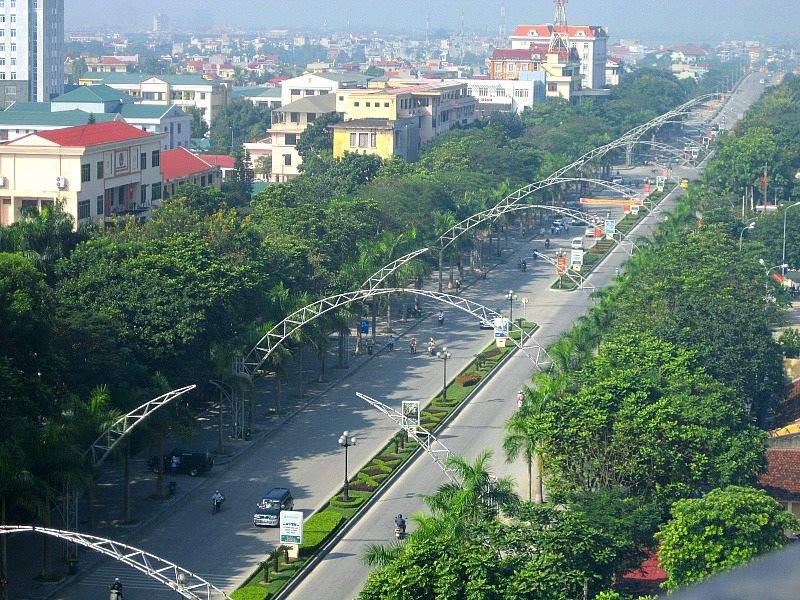
As central position of province, Thanh Hoa city is the heart of transport network, where every essential transportation modes are aggregated such as North–South Railway (Vietnam), National Route 1A (Vietnam), National Route 47, buses system and many other provincial routes.
Le Mon port is situated beside Ma River and 4 km from city centre east. This river port supports and provides transportation for Le Mon industrial region.
In February 2013, Tho Xuan Airport, which is located 45 km to the east from city, was implemented and upgrade to turn into a mixed civilian/military airport. This airport became the place provide air transport services for Thanh Hoa city.
References
- Robert Trando Letters of a Vietnamese Émigré -2010 Page 144 "The name of its city is Thanh Hóa City."
- "Citadel of the Ho Dynasty".
- Keat Gin Ooi Southeast Asia: A Historical Encyclopedia, from Angkor Wat to East ... Volume 1 - Page 805 2004 "Mac efforts notwithstanding, many people went south to support the restoration of the Le dynasty in Thanh Hoa. Throughout the sixteenth century, Mac-Le animosity was played out on the battlefield."
- Vietnam Insight Guides 2002 - Page 20 "The southern court is founded near Thanh Hoa. 1592: The death of Mac dynasty's last king, Mac Mau Hop, ends the war."
- Van Dao Hoang Viet Nam Quoc Dan Dang: A Contemporary History of a National Struggle: 1927-1954 2008 Page 331 "Afterward, the VC transported all Party members and their weapons to Thanh Hóa city."
- "Vietnam Building Code Natural Physical & Climatic Data for Construction" (PDF). Vietnam Institute for Building Science and Technology. Archived from the original (PDF) on 22 July 2018. Retrieved 31 July 2018.
Districts of Vietnam North Central Coast | ||
|---|---|---|
| Thanh Hóa province | 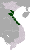 | |
| Nghệ An province | ||
| Hà Tĩnh province | ||
| Quảng Bình province |
| |
| Quảng Trị province |
| |
| Thừa Thiên Huế province |
| |
※ denotes provincial seat. | ||
Authority control | |
|---|---|
| General | |
| National libraries | |
| Other |
|
На других языках
- [en] Thanh Hóa
[ru] Тханьхоа
Тханьхоа́ (вьетн. Thanh Hóa) — город во Вьетнаме, административный центр одноимённой провинции Тханьхоа. Население — 406 550 человек (2014). Расположен к югу от дельты Красной реки в 137 километрах к югу от Ханоя на притоке реки Ма (Mã). Связан дорогами со столицей и представляет собой растущий торговый и индустриальный центр.Другой контент может иметь иную лицензию. Перед использованием материалов сайта WikiSort.org внимательно изучите правила лицензирования конкретных элементов наполнения сайта.
WikiSort.org - проект по пересортировке и дополнению контента Википедии