world.wikisort.org - Vietnam
Thanh Hóa (Vietnamese: [tʰajŋ̟˧˧ hwaː˧˦] (![]() listen)) is a province in the North Central Coast region of Vietnam. This is a relatively large province, which ranks as fifth in area and as third in population among 63 central administrative subdivisions. Its capital and largest city is Thanh Hóa City. The province is widely called Xứ Thanh (The Land of Thanh).
listen)) is a province in the North Central Coast region of Vietnam. This is a relatively large province, which ranks as fifth in area and as third in population among 63 central administrative subdivisions. Its capital and largest city is Thanh Hóa City. The province is widely called Xứ Thanh (The Land of Thanh).
Thanh Hóa province
Tỉnh Thanh Hóa | |
|---|---|
Province | |
              Citadel of the Hồ Dynasty • Sông Mực Lake • Hải Hòa Beach • Trống Mái Mountain • Cẩm Lương fish stream • Mai An Tiêm Temple • Lam Kinh Temple • Phú Lệ Suspension bridge • Bà Triệu Temple • Dạ Lộc Temple • Lê Lợi Mausoleum • Lê Lợi Statue | |
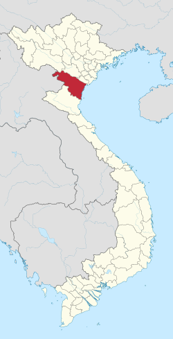 Location of Thanh Hóa within Vietnam | |
 | |
| Coordinates: 20°0′N 105°30′E | |
| Country | |
| Region | North Central Coast |
| Capital (and Largest city) | Thanh Hóa |
| Government | |
| • People's Council Chair | Trịnh Văn Chiến |
| • People's Committee Chair | Nguyễn Đình Xứng |
| Area | |
| • Total | 11,129.5 km2 (4,297.1 sq mi) |
| Population (2021)[2] | |
| • Total | 3,673,900 |
| • Density | 330/km2 (850/sq mi) |
| Demographics | |
| • Ethnicities | Vietnamese, Mường, Thai, Thổ, Dao, and H'Mông |
| Time zone | UTC+7 (ICT) |
| Area codes | 237 |
| ISO 3166 code | VN-21 |
| Website | www |
Human civilization has existed in Thanh Hóa for about 6,000 years ago, as one of the earliest centers of the ancient Vietnamese. Archaeological excavations have revealed that the first culture presented was the Đa Bút Culture, a culture located along the Sông Đáy river and the Sông Mã river.
Thanh Hóa is located in the middle of North Vietnam and North Central Coast as a transition in many aspects: geology, climate, administrative division and local culture. Thus, these factors show that Xứ Thanh is a province with many particular local habits and customs and cultures.
Thanh Hóa has two provincial cities, one district-level town and 24 rural districts with an area of 11,133.4 km2 and a population of approximate 3.6 million. Sầm Sơn city is a famous seaside resort situated 16 km from the Thanh Hóa city centre. Whilst, Bỉm Sơn township is a large industrial centre, especially cement. Nghi Sơn is a promising Economic zone, expected to be central of Thanh Hoa's Industrial with large Refinery Factory, Deepwater Seaport and many projects in progress. The province is also home of many ethnic groups, in which the most seven ethnicities are Kinh, Mường, Thái, H'Mông, Dao, Thổ, Khơ-mú with mentions of the legend Long Quân. ("Dragon Lord of Lac")
Geography
Geographic position
The coordinate was accurately measured as 19°18'N - 20°40'N (from the southernmost point to northernmost point), 104°22'E - 106°05'E (from the westernmost point to easternmost point). It borders the following provinces: Sơn La, Hòa Bình, Ninh Bình, Nghệ An, it also neighbors Houaphanh province for 192 km boundary line furthermore.
Administrative divisions
Thanh Hóa is subdivided into 27 district-level sub-divisions:
- 23 rural districts:
- Bá Thước
- Cẩm Thủy
- Đông Sơn
- Hà Trung
- Hậu Lộc
- Hoằng Hóa
- Lang Chánh
- Mường Lát
- Nga Sơn
- Ngọc Lặc
- Như Thanh
- Như Xuân
- Nông Cống
- Quan Hóa
- Quan Sơn
- Quảng Xương
- Thạch Thành
- Thiệu Hóa
- Thọ Xuân
- Thường Xuân
- Triệu Sơn
- Vĩnh Lộc
- Yên Định
- 2 district-level towns:
They are further subdivided into 28 commune-level towns (or townlets), 579 communes, and 30 wards.
Etymology
The province's name derives from Sino-Vietnamese 清化.
External links
References
Places adjacent to Thanh Hóa province | ||||||||||||||||
|---|---|---|---|---|---|---|---|---|---|---|---|---|---|---|---|---|
| ||||||||||||||||
2 provincial cities, 2 district-level towns, 23 districts 60 wards, 30 commune-level towns, 469 communes | ||
| Thanh Hóa City (capital) | Wards (30):
An Hưng ·
Ba Đình ·
Điện Biên ·
Đông Cương ·
Đông Hải ·
Đông Hương ·
Đông Lĩnh ·
Đông Sơn ·
Đông Tân ·
Đông Thọ ·
Đông Vệ ·
Hàm Rồng ·
Lam Sơn ·
Long Anh ·
Nam Ngạn ·
Ngọc Trạo ·
Phú Sơn ·
Quảng Cát ·
Quảng Đông ·
Quảng Hưng ·
Quảng Phú ·
Quảng Tâm ·
Quảng Thành ·
Quảng Thắng ·
Quảng Thịnh ·
Tào Xuyên ·
Tân Sơn ·
Thiệu Dương ·
Thiệu Khánh ·
Trường Thi
|  |
| Sầm Sơn City | Wards (08):
Bắc Sơn ·
Trung Sơn ·
Trường Sơn ·
Quảng Cư ·
Quảng Châu ·
Quảng Thọ ·
Quảng Tiến ·
Quảng Vinh
| |
| Bỉm Sơn Town | Wards (06):
Ba Đình ·
Bắc Sơn ·
Đông Sơn ·
Lam Sơn ·
Ngọc Trạo ·
Phú Sơn
| |
| Nghi Sơn Town | Wards (16):
Bình Minh ·
Hải An ·
Hải Bình ·
Hải Châu ·
Hải Hòa ·
Hải Lĩnh ·
Hải Ninh ·
Hải Thanh ·
Hải Thượng ·
Mai Lâm ·
Nguyên Bình ·
Ninh Hải ·
Tân Dân ·
Tĩnh Hải ·
Trúc Lâm ·
Xuân Lâm
| |
| Bá Thước District | Township (01):
Cành Nàng (capital)
| |
| Cẩm Thủy District | Township (01):
Phong Sơn (capital)
| |
| Đông Sơn District | Township (01):
Rừng Thông (capital)
| |
| Hà Trung District | Township (01):
Hà Trung (capital)
| |
| Hậu Lộc District | Township (01):
Hậu Lộc (capital)
| |
| Hoằng Hóa District | Township (01):
Bút Sơn (capital)
| |
| Lang Chánh District | Township (01):
Lang Chánh (capital)
| |
| Mường Lát District | Township (01):
Mường Lát (capital)
| |
| Nga Sơn District | Township (01):
Nga Sơn (capital)
| |
| Ngọc Lặc District | Township (01):
Ngọc Lặc (capital)
| |
| Như Thanh District | Township (01):
Bến Sung (capital)
| |
| Như Xuân District | Township (01):
Yên Cát (capital)
| |
| Nông Cống District | Township (01):
Nông Cống (capital)
| |
| Quan Hóa District | Township (01):
Hồi Xuân (capital)
| |
| Quan Sơn District | Township (01):
Sơn Lư (capital)
| |
| Quảng Xương District | Township (01):
Tân Phong (capital)
| |
| Thạch Thành District | Townships (02):
Kim Tân (capital) ·
Vân Du
| |
| Thiệu Hóa District | Township (01):
Thiệu Hóa (capital)
| |
| Thọ Xuân District | Townships (03):
Thọ Xuân (capital) ·
Lam Sơn ·
Sao Vàng
| |
| Thường Xuân District | Township (01):
Thường Xuân (capital)
| |
| Triệu Sơn District | Townships (02):
Triệu Sơn (capital) ·
Nưa
| |
| Vĩnh Lộc District | Township (01):
Vĩnh Lộc (capital)
| |
| Yên Định District | Townships (04):
Quán Lào (capital) ·
Quý Lộc ·
Thống Nhất ·
Yên Lâm
| |
Districts of Vietnam North Central Coast | ||
|---|---|---|
| Thanh Hóa province | 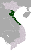 | |
| Nghệ An province | ||
| Hà Tĩnh province | ||
| Quảng Bình province |
| |
| Quảng Trị province |
| |
| Thừa Thiên Huế province |
| |
※ denotes provincial seat. | ||
Authority control | |
|---|---|
| General | |
| National libraries | |
| Other |
|
На других языках
[de] Thanh Hóa (Provinz)
Thanh Hóa ist eine Küstenprovinz in der Nördlichen Küstenregion von Vietnam, ca. 150 km südlich von Hà Nội und 1560 km nördlich von Thành phố Hồ Chí Minh (Hồ-Chí-Minh-Stadt). Thanh Hóa hat eine Fläche von 11.116,3 km² und ca. 3,6 Millionen Einwohner.- [en] Thanh Hóa province
[ru] Тханьхоа (провинция)
Тханьхоа́ (вьетн. Thanh Hóa, тьы-ном 淸化) — провинция на севере центральной части Вьетнама.Другой контент может иметь иную лицензию. Перед использованием материалов сайта WikiSort.org внимательно изучите правила лицензирования конкретных элементов наполнения сайта.
WikiSort.org - проект по пересортировке и дополнению контента Википедии