world.wikisort.org - Vietnam
Sơn La (Vietnamese: [ʂəːn˧˧ laː˧˧] (![]() listen)) is a province in the Northwest region of Vietnam. It borders Laos to the south. The province covers an area of 14,123.49 square kilometres and as of 2019 it had a population of 1,248,415.[3] The population includes Black and White Tai ethnic group.
listen)) is a province in the Northwest region of Vietnam. It borders Laos to the south. The province covers an area of 14,123.49 square kilometres and as of 2019 it had a population of 1,248,415.[3] The population includes Black and White Tai ethnic group.
Sơn La province
Tỉnh Sơn La | |
|---|---|
Province | |
    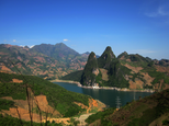    Mường La Mountain • Sơn La Dam • Dải Yếm Waterfall • Bản Phúc Mountain • Mộc Châu Mountain • Quỳnh Nhai Mountain pass • Pha Đin Mountain pass • Sơn La City | |
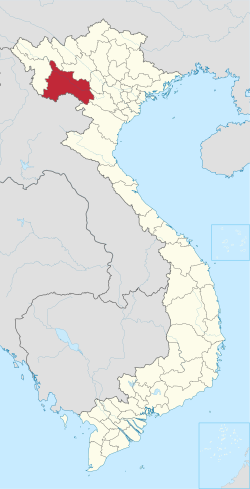 Location of Sơn La within Vietnam | |
 | |
| Coordinates: 21°10′N 104°0′E | |
| Country | |
| Region | Northwest |
| Capital | Sơn La |
| Subdivision | 1 city, 11 rural districts |
| Government | |
| • Type | Province |
| • Body | Sơn La Provincial People's Council |
| • Chairman of People's Council | Nguyễn Thái Hưng |
| • Chairman of People's Committee | Hoàng Quốc Khánh |
| Area | |
| • Province | 14,123.5 km2 (5,453.1 sq mi) |
| Population (2021)[3] | |
| • Province | 1,255,826 |
| • Density | 89/km2 (230/sq mi) |
| • Urban | 202,589 |
| Ethnic groups | |
| • Thái | 53.61% |
| • Vietnamese[4] | 16.26% |
| • Mông | 16.06% |
| • Mường | 6.78% |
| • Xinh Mun | 2.17% |
| • Others | 5.12% |
| Time zone | UTC+7 (ICT) |
| Area codes | 212 |
| ISO 3166 code | VN-05 |
| Website | www |
Sơn La Dam, the largest hydroelectric power station in Southeast Asia.[5] is located in this province.
Administrative divisions
Sơn La is subdivided into 12 district-level sub-divisions and 204 commune-level sub-divisions:
| Administrative divisions of Sơn La | ||||||||||||||||||||||||||||||||||||||||||||||||||||||||||||||||||
|---|---|---|---|---|---|---|---|---|---|---|---|---|---|---|---|---|---|---|---|---|---|---|---|---|---|---|---|---|---|---|---|---|---|---|---|---|---|---|---|---|---|---|---|---|---|---|---|---|---|---|---|---|---|---|---|---|---|---|---|---|---|---|---|---|---|---|
|
|
|||||||||||||||||||||||||||||||||||||||||||||||||||||||||||||||||
See also
- Nà Sản Airport
- Mộc Châu plateau
References
- "Phê duyệt và công bố kết quả thống kê Area đất đai của cả nước năm 2018" [Announcements of area statistics for the whole country in 2018]. Act No. 2908/QĐ-BTNMT of November 13, 2019 (in Vietnamese). Ministry of Natural Resources and Environment (Vietnam). - the data in the report are in hectares, rounded to integers
- "STATISTICAL YEARBOOK 2019". General Statistics Office of Vietnam. 2020-06-30.
- General Statistics Office of Vietnam (2019). "Completed Results of the 2019 Viet Nam Population and Housing Census" (PDF). Statistical Publishing House (Vietnam). ISBN 978-604-75-1532-5.
- Also called Kinh people
- "Huge hydro plant starts operation in Vietnam, says official". Intellasia News Services. 2010-12-22. Retrieved 2011-01-22.
External links
Places adjacent to Sơn La province | ||||||||||||||||
|---|---|---|---|---|---|---|---|---|---|---|---|---|---|---|---|---|
| ||||||||||||||||
Authority control | |
|---|---|
| General | |
| National libraries | |
| Other |
|
This article about a location in Sơn La Province, Vietnam is a stub. You can help Wikipedia by expanding it. |
На других языках
- [en] Sơn La province
[ru] Шонла (провинция)
Шо́нла (вьетн. Sơn La) — провинция в северо-западной части Вьетнама. Население по данным на 2009 год — 1 080 641 человек. Плотность населения — 76,24 чел./км². Административный центр — одноимённый город[1].Текст в блоке "Читать" взят с сайта "Википедия" и доступен по лицензии Creative Commons Attribution-ShareAlike; в отдельных случаях могут действовать дополнительные условия.
Другой контент может иметь иную лицензию. Перед использованием материалов сайта WikiSort.org внимательно изучите правила лицензирования конкретных элементов наполнения сайта.
Другой контент может иметь иную лицензию. Перед использованием материалов сайта WikiSort.org внимательно изучите правила лицензирования конкретных элементов наполнения сайта.
2019-2025
WikiSort.org - проект по пересортировке и дополнению контента Википедии
WikiSort.org - проект по пересортировке и дополнению контента Википедии