world.wikisort.org - USA
Trumbull County is a county in the far northeast portion of U.S. state of Ohio. As of the 2020 census, the population was 201,977.[2] Its county seat is Warren, which developed industry along the Mahoning River.[3] Trumbull County is part of the Youngstown-Warren-Boardman, OH-PA Metropolitan Statistical Area.
Trumbull County | |
|---|---|
U.S. county | |
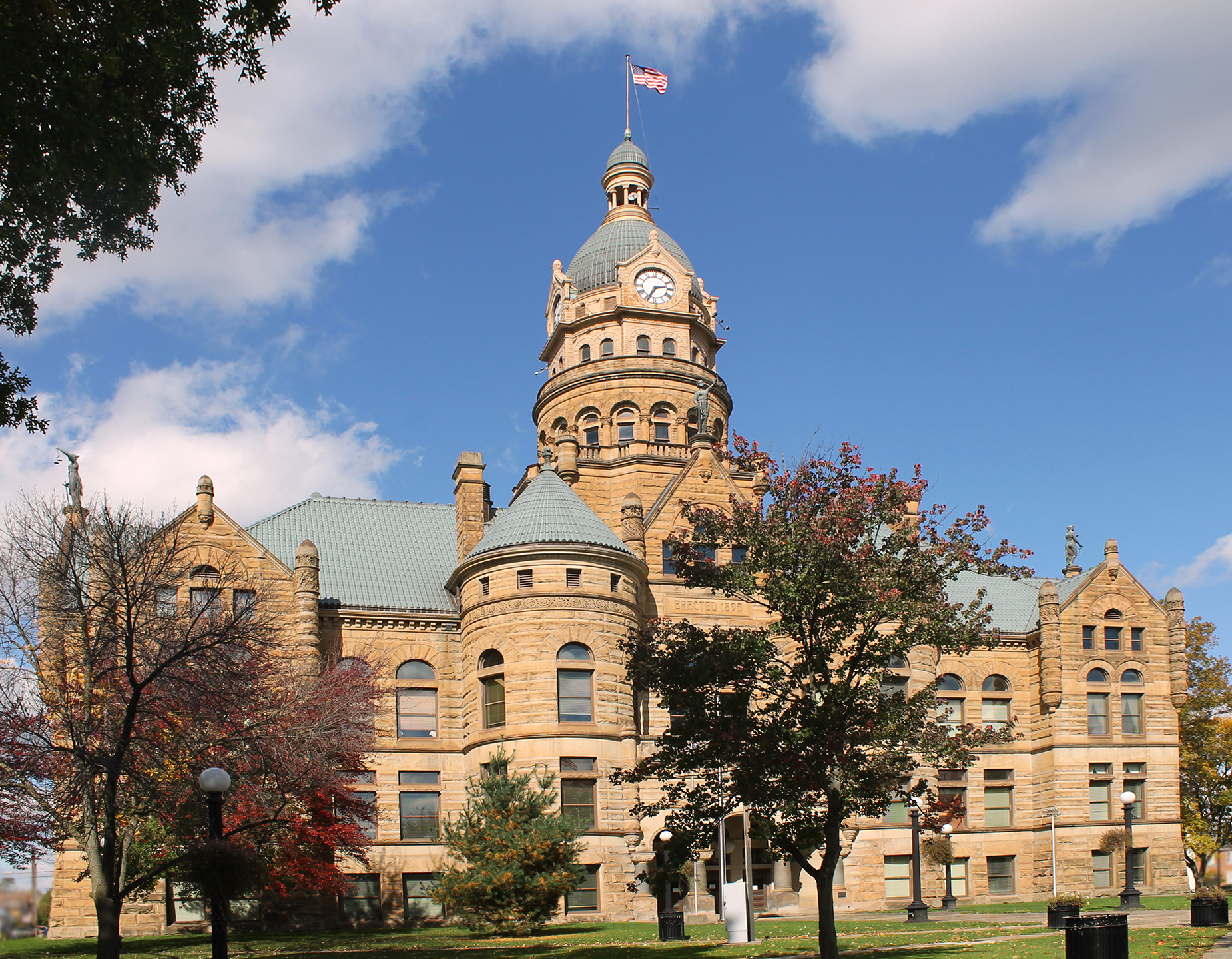 Trumbull County Courthouse | |
 Seal | |
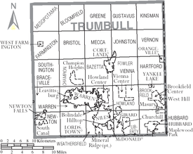
 Location within the U.S. state of Ohio | |
 Ohio's location within the U.S. | |
| Coordinates: 41°19′N 80°46′W | |
| Country | |
| State | |
| Founded | July 10, 1800[1] |
| Named for | Jonathan Trumbull |
| Seat | Warren |
| Largest city | Warren |
| Area | |
| • Total | 637 sq mi (1,650 km2) |
| • Land | 618 sq mi (1,600 km2) |
| • Water | 18 sq mi (50 km2) 2.9%% |
| Population (2020) | |
| • Total | 201,977 |
| • Estimate (2021) | 201,335 |
| • Density | 320/sq mi (120/km2) |
| Time zone | UTC−5 (Eastern) |
| • Summer (DST) | UTC−4 (EDT) |
| Congressional districts | 13th, 14th |
| Website | www |
History
In the early years of the European discovery and exploration of the New World, the land that became Trumbull County was originally claimed by French explorers as part of the French colony of Canada (New France). Their settlements had some fur traders who interacted with Native American tribes in this area. After losing the Seven Years' War to Great Britain, France was forced to cede its territories east of the Mississippi River in 1763. Great Britain renamed New France as the Province of Quebec.
Following the United States' victory in its Revolutionary War, the British were forced to cede this land to the new nation. The federal government convinced Connecticut to give up its claim to the land, but it was known as part of the Connecticut Western Reserve in the Northwest Territory. Connecticut retained sovereignty over some of the eastern portion of what became Ohio, selling this area in 1795 to the Connecticut Land Company, a speculative private development firm. As first organized, Trumbull County consisted of the entire area of the Connecticut Western Reserve before population increased, and it was divided into smaller counties. The county's main city, Warren, was originally founded as the capitol of the Western Reserve territory.[4] No Native American settlements have ever formally been identified in Trumbull County, however artifacts are uncovered often. Before 1600, the area was ambiguously between the territories of the Erie people to the east and the Whittlesey Culture to the west. It is currently unknown precisely where one tribe's territory ended and the other began. After the Beaver Wars, the area was frequented by travelling Lenape, Wyandot, Shawnee and Seneca, who all had settlements nearby for a time and shared the valley's animal, food and medicinal resources. They also regularly panned for salt in the marshes.
The county is named for Jonathan Trumbull, Governor of Connecticut, who once owned the land in this region.[5] Early settlements were made along the Mahoning River and other waterways, which provided transportation access and water power to the industries that developed later in the 19th century.
Geography
According to the United States Census Bureau, the county has a total area of 637 square miles (1,650 km2), of which 618 square miles (1,600 km2) is land and 18 square miles (47 km2) (2.9%) is water.[6] It is approximately a square with sides of 25 miles; it is the only square county in Ohio.[7]
Adjacent counties
- Ashtabula County (north)
- Crawford County, Pennsylvania (northeast)
- Mercer County, Pennsylvania (east)
- Mahoning County (south)
- Portage County (southwest)
- Geauga County (northwest)
Major highways
 US 62
US 62 US 422
 SR 5
SR 5 SR 7
SR 7 SR 11
SR 11 SR 45
SR 45 SR 46
SR 46 SR 82
SR 82 SR 87
SR 87 SR 88
SR 88 SR 169
 SR 193
 SR 304
 SR 305
Demographics
| Historical population | |||
|---|---|---|---|
| Census | Pop. | %± | |
| 1800 | 1,302 | — | |
| 1810 | 8,671 | 566.0% | |
| 1820 | 15,546 | 79.3% | |
| 1830 | 26,153 | 68.2% | |
| 1840 | 38,107 | 45.7% | |
| 1850 | 30,490 | −20.0% | |
| 1860 | 30,656 | 0.5% | |
| 1870 | 38,659 | 26.1% | |
| 1880 | 44,880 | 16.1% | |
| 1890 | 42,373 | −5.6% | |
| 1900 | 46,591 | 10.0% | |
| 1910 | 52,766 | 13.3% | |
| 1920 | 83,920 | 59.0% | |
| 1930 | 123,063 | 46.6% | |
| 1940 | 132,315 | 7.5% | |
| 1950 | 158,915 | 20.1% | |
| 1960 | 208,526 | 31.2% | |
| 1970 | 232,579 | 11.5% | |
| 1980 | 241,863 | 4.0% | |
| 1990 | 227,813 | −5.8% | |
| 2000 | 225,116 | −1.2% | |
| 2010 | 210,312 | −6.6% | |
| 2020 | 201,977 | −4.0% | |
| 2021 (est.) | 201,335 | [8] | −0.3% |
| U.S. Decennial Census[9] 1790-1960[10] 1900-1990[11] 1990-2000[12] 2010-2020[2] | |||
2010 census
As of the census of 2010, there were 210,312 people, 86,011 households, and 56,874 families living in the county.[13] The population density was 340.1 inhabitants per square mile (131.3/km2). There were 96,163 housing units at an average density of 155.5 per square mile (60.0/km2).[14] The racial makeup of the county was 89.0% white, 8.3% black or African American, 0.5% Asian, 0.2% American Indian, 0.3% from other races, and 1.8% from two or more races. Those of Hispanic or Latino origin made up 1.3% of the population.[13] In terms of ancestry, 21.6% were German, 16.5% were American, 14.3% were Irish, 13.7% were Italian, and 10.6% were English.[15]
Of the 86,011 households, 28.8% had children under the age of 18 living with them, 47.4% were married couples living together, 13.7% had a female householder with no husband present, 33.9% were non-families, and 29.2% of all households were made up of individuals. The average household size was 2.40 and the average family size was 2.95. The median age was 42.8 years.[13]
The median income for a household in the county was $42,296 and the median income for a family was $52,731. Males had a median income of $43,382 versus $30,859 for females. The per capita income for the county was $21,854. About 11.5% of families and 15.4% of the population were below the poverty line, including 24.9% of those under age 18 and 8.1% of those age 65 or over.[16]
2000 census
As of the census of 2000, there were 225,116 people, 89,020 households, and 61,690 families living in the county. The population density was 365 people per square mile (141/km2). There were 95,117 housing units at an average density of 154 per square mile (60/km2). The racial makeup of the county was 90.21% White, 7.90% Black or African American, 0.15% Native American, 0.45% Asian, 0.02% Pacific Islander, 0.21% from other races, and 1.07% from two or more races. 0.80% of the population were Hispanic or Latino of any race. 94.6% spoke English and 1.0% German as their first language.
There were 89,020 households, out of which 29.90% had children under the age of 18 living with them, 52.90% were married couples living together, 12.50% had a female householder with no husband present, and 30.70% were non-families. 26.90% of all households were made up of individuals, and 11.40% had someone living alone who was 65 years of age or older. The average household size was 2.48 and the average family size was 3.02.
In the county, the population was spread out, with 24.40% under the age of 18, 7.70% from 18 to 24, 27.30% from 25 to 44, 24.80% from 45 to 64, and 15.70% who were 65 years of age or older. The median age was 39 years. For every 100 females there were 93.80 males. For every 100 females age 18 and over, there were 90.60 males.
The median income for a household in the county was $38,298, and the median income for a family was $46,203. Males had a median income of $36,823 versus $24,443 for females. The per capita income for the county was $19,188. About 7.90% of families and 10.30% of the population were below the poverty line, including 15.40% of those under age 18 and 7.60% of those age 65 or over.
Politics
Trumbull County was historically a Democratic stronghold; in 2016, however, Donald Trump won the county by a reasonably comfortable margin of 6.22%, being the first Republican to win the county since Richard Nixon in 1972.[17] Trump expanded his margin in the county to 10.6 points in 2020.[18]
| Year | Republican | Democratic | Third party | |||
|---|---|---|---|---|---|---|
| No. | % | No. | % | No. | % | |
| 2020 | 55,194 | 54.57% | 44,519 | 44.01% | 1,439 | 1.42% |
| 2016 | 49,024 | 50.71% | 43,014 | 44.49% | 4,638 | 4.80% |
| 2012 | 38,279 | 37.54% | 61,672 | 60.48% | 2,012 | 1.97% |
| 2008 | 40,164 | 37.44% | 64,145 | 59.80% | 2,962 | 2.76% |
| 2004 | 40,977 | 37.89% | 66,673 | 61.65% | 495 | 0.46% |
| 2000 | 34,654 | 36.01% | 57,643 | 59.90% | 3,942 | 4.10% |
| 1996 | 24,811 | 26.19% | 55,604 | 58.69% | 14,330 | 15.12% |
| 1992 | 25,831 | 24.01% | 54,591 | 50.73% | 27,184 | 25.26% |
| 1988 | 38,815 | 39.51% | 58,674 | 59.72% | 761 | 0.77% |
| 1984 | 45,623 | 44.18% | 56,902 | 55.11% | 734 | 0.71% |
| 1980 | 41,056 | 44.15% | 44,366 | 47.70% | 7,580 | 8.15% |
| 1976 | 36,469 | 39.41% | 53,828 | 58.16% | 2,247 | 2.43% |
| 1972 | 47,680 | 55.92% | 35,278 | 41.37% | 2,308 | 2.71% |
| 1968 | 33,076 | 39.97% | 40,365 | 48.77% | 9,319 | 11.26% |
| 1964 | 27,059 | 33.24% | 54,342 | 66.76% | 0 | 0.00% |
| 1960 | 40,724 | 46.46% | 46,928 | 53.54% | 0 | 0.00% |
| 1956 | 43,936 | 57.17% | 32,913 | 42.83% | 0 | 0.00% |
| 1952 | 37,793 | 49.17% | 39,062 | 50.83% | 0 | 0.00% |
| 1948 | 25,297 | 39.91% | 37,097 | 58.52% | 998 | 1.57% |
| 1944 | 25,150 | 42.30% | 34,312 | 57.70% | 0 | 0.00% |
| 1940 | 25,026 | 41.96% | 34,615 | 58.04% | 0 | 0.00% |
| 1936 | 16,887 | 33.55% | 32,384 | 64.34% | 1,058 | 2.10% |
| 1932 | 23,029 | 53.66% | 17,871 | 41.64% | 2,013 | 4.69% |
| 1928 | 29,710 | 75.80% | 9,110 | 23.24% | 374 | 0.95% |
| 1924 | 22,341 | 74.35% | 4,007 | 13.33% | 3,701 | 12.32% |
| 1920 | 17,343 | 68.66% | 6,815 | 26.98% | 1,101 | 4.36% |
| 1916 | 6,167 | 47.15% | 6,091 | 46.57% | 822 | 6.28% |
| 1912 | 2,633 | 23.15% | 3,347 | 29.42% | 5,395 | 47.43% |
| 1908 | 6,978 | 58.00% | 4,476 | 37.20% | 577 | 4.80% |
| 1904 | 7,383 | 68.37% | 2,110 | 19.54% | 1,306 | 12.09% |
| 1900 | 7,723 | 65.71% | 3,686 | 31.36% | 344 | 2.93% |
| 1896 | 7,867 | 66.23% | 3,829 | 32.24% | 182 | 1.53% |
| 1892 | 5,819 | 59.45% | 3,217 | 32.87% | 752 | 7.68% |
| 1888 | 6,299 | 62.47% | 3,177 | 31.51% | 607 | 6.02% |
| 1884 | 6,521 | 65.35% | 3,000 | 30.07% | 457 | 4.58% |
| 1880 | 6,796 | 66.39% | 3,148 | 30.75% | 293 | 2.86% |
| 1876 | 6,133 | 63.77% | 3,030 | 31.51% | 454 | 4.72% |
| 1872 | 5,869 | 70.68% | 2,321 | 27.95% | 114 | 1.37% |
| 1868 | 5,338 | 69.77% | 2,313 | 30.23% | 0 | 0.00% |
| 1864 | 5,093 | 72.83% | 1,900 | 27.17% | 0 | 0.00% |
| 1860 | 4,349 | 69.22% | 1,672 | 26.61% | 262 | 4.17% |
| 1856 | 4,049 | 67.63% | 1,920 | 32.07% | 18 | 0.30% |
Government
County commissioners
| Commissioner | Party | Title |
|---|---|---|
| Frank S. Fuda | Democratic | President |
| Mauro Cantalamessa | Democratic | |
| Niki Frenchko | Republican | |
County officials
| Office | Official | Party |
|---|---|---|
| Auditor | Adrian Biviano | Democratic |
| Clerk of Courts | Karen Infante Allen | Democratic |
| Coroner | Lawrence D'Amico | Democratic |
| Engineer | Randy L. Smith | Democratic |
| Prosecuting Attorney | Dennis Watkins | Democratic |
| Recorder | Tod Latell | Democratic |
| Sheriff | Paul S. Monroe | Democratic |
| Treasurer | Sam Lamancusa | Democratic |
Judgeships
| Court | Judge | Party |
|---|---|---|
| Court of Common Pleas | Cynthia Wescott Rice | Democratic |
| Court of Common Pleas | W. Wyatt McKay | Democratic |
| Court of Common Pleas | Ronald J. Rice | Democratic |
| Court of Common Pleas | Andrew D. Logan | Democratic |
| Court of Common Pleas Juvenile Division | Sandra Stabile Harwood | Democratic |
| Court of Common Pleas Juvenile Division | Samuel F. Bluedorn | Democratic |
| Court of Common Pleas Probate Court | James A. Fredericka | Democratic |
| County Municipal Court, Central District | Thomas A. Campbell | Republican |
| County Municipal Court, Eastern District | Marty D. Nosich | Independent |
| Girard Municipal Court | Jeffrey D. Adler | Democratic |
| Newton Falls Municipal Court | Philip M. Vigorito | Democratic |
| Niles Municipal Court | Christopher J. Shaker | Democratic |
| Warren Municipal Court | Thomas P. Gysegem | Democratic |
| Warren Municipal Court | Terry F. Ivanchak | Republican |
| 11th District Court of Appeals | VACANT | |
| 11th District Court of Appeals | Thomas R. Wright | Democratic |
| 11th District Court of Appeals | Mary Jane Trapp | Democratic |
| 11th District Court of Appeals | Matt Lynch | Republican |
| 11th District Court of Appeals | John J. Eklund | Republican |
Ohio House of Representatives
| District | Representative | Party |
|---|---|---|
| 64 | Michael O'Brien | Democratic |
| 65 | Mike Loychik | Republican |
Ohio State Senate
| District | Senator | Party |
|---|---|---|
| 32 | Sandra O'Brien | Republican |
United States House of Representatives
| District | Representative | Party |
|---|---|---|
| 13 | Tim Ryan | Democratic |
| 14 | David Joyce | Republican |
United States Senate
| Senator | Party |
|---|---|
| Sherrod Brown | Democratic |
| Rob Portman | Republican |
Higher learning
- Kent State University Trumbull is a regional campus of Kent State University, offering several associate degrees and a few bachelor's degrees.[20]
- Trumbull County Career and Technical Center is a vocational school, offering different learning and career advancement opportunities for both high school and adult learners.[21]
Communities
Cities
Villages
Townships
Defunct township
Census-designated places
Unincorporated communities
- Bristolville
- Burghill
- Center of the World
- Farmdale
- Fowler
- Hartford
- North Bloomfield
- Southington
Ghost towns
- Antietam (in Hartford)
- Bentley (in Brookfield)
- Brockway (in Hartford)
- Chestnut Ridge (in Hubbard)
- Dewey (in Kinsman)
- Doughton (in Hubbard)
- Germantown (in Hubbard)
- Kingsbury (in Mecca)
- Longsville (in Hubbard)
- Mosier (in Liberty)
- Oil Diggings (in Mecca)
- Old Burg Hill (in Hartford)
- Penza (Liberty/ Hubbard border)
- Superior (in Vernon)
- Walnut Hill (in Brookfield)
- Wassie (Bristolville/ Champion border)
- York (in Gustavus)
- Ohltown (in Weathersfield)
The Camp Ravenna Joint Military Training Center, formally known as the Ravenna Training and Logistics Site and commonly known as the Ravenna Arsenal, occupies a small part of Braceville Township.
See also
- National Register of Historic Places listings in Trumbull County, Ohio
References
- Specific
- "Ohio County Profiles: Trumbull County" (PDF). Ohio Department of Development. Archived from the original (PDF) on June 21, 2007. Retrieved April 28, 2007.
- "State & County QuickFacts". United States Census Bureau. Retrieved August 28, 2022.
- "Find a County". National Association of Counties. Archived from the original on May 31, 2011. Retrieved June 7, 2011.
- About Warren: "Early History" Archived February 10, 2009, at the Wayback Machine, City of Warren, Ohio
- "Trumbull County data". Ohio State University Extension Data Center. Archived from the original on September 27, 2016. Retrieved April 28, 2007.
- "2010 Census Gazetteer Files". United States Census Bureau. August 22, 2012. Archived from the original on May 4, 2014. Retrieved February 11, 2015.
- "TRUMBULL COUNTY TOURISM BUREAU". Archived from the original on April 24, 2009.
- "Annual Estimates of the Resident Population for Counties: April 1, 2020 to July 1, 2021". Retrieved August 28, 2022.
- "U.S. Decennial Census". United States Census Bureau. Retrieved February 11, 2015.
- "Historical Census Browser". University of Virginia Library. Retrieved February 11, 2015.
- Forstall, Richard L., ed. (March 27, 1995). "Population of Counties by Decennial Census: 1900 to 1990". United States Census Bureau. Retrieved February 11, 2015.
- "Census 2000 PHC-T-4. Ranking Tables for Counties: 1990 and 2000" (PDF). United States Census Bureau. April 2, 2001. Archived (PDF) from the original on October 9, 2022. Retrieved February 11, 2015.
- "DP-1 Profile of General Population and Housing Characteristics: 2010 Demographic Profile Data". United States Census Bureau. Archived from the original on February 13, 2020. Retrieved January 19, 2016.
- "Population, Housing Units, Area, and Density: 2010 - County". United States Census Bureau. Archived from the original on February 13, 2020. Retrieved January 19, 2016.
- "DP02 SELECTED SOCIAL CHARACTERISTICS IN THE UNITED STATES – 2006-2010 American Community Survey 5-Year Estimates". United States Census Bureau. Archived from the original on February 13, 2020. Retrieved January 19, 2016.
- "DP03 SELECTED ECONOMIC CHARACTERISTICS – 2006-2010 American Community Survey 5-Year Estimates". United States Census Bureau. Archived from the original on February 13, 2020. Retrieved January 19, 2016.
- Sullivan, Robert David; ‘How the Red and Blue Map Evolved Over the Past Century’; America Magazine in The National Catholic Review; June 29, 2016
- "Trumbull County Board of Elections". boe.co.trumbull.oh.gov. Retrieved October 26, 2022.
- Leip, David. "Dave Leip's Atlas of U.S. Presidential Elections". uselectionatlas.org. Retrieved May 3, 2018.
- Kent State University Trumbull
- "Home". tctcadulttraining.org.
- "Trumbull County". August 26, 2018.
External links
Places adjacent to Trumbull County, Ohio | |
|---|---|
Municipalities and communities of Trumbull County, Ohio, United States | ||
|---|---|---|
County seat: Warren | ||
| Cities |  | |
| Villages | ||
| Townships | ||
| CDPs | ||
| Unincorporated communities |
| |
| Footnotes | ‡This populated place also has portions in an adjacent county or counties | |
| ||
Authority control | |
|---|---|
| General | |
| National libraries | |
| Other |
|
На других языках
[de] Trumbull County
Trumbull County[1] ist ein County im US-Bundesstaat Ohio. Der Verwaltungssitz (County Seat) ist Warren.- [en] Trumbull County, Ohio
[es] Condado de Trumbull
El condado de Trumbull (en inglés: Trumbull County), fundado en 1820, es uno de 92 condados del estado estadounidense de Ohio. En el año 2000, el condado tenía una población de 225,116 habitantes y una densidad poblacional de 141 personas por km². La sede del condado es Warren.[1] El condado recibe su nombre por el Río Tuscarawas.[ru] Трамбулл (округ)
Округ Трамбулл (англ. Trumbull County) располагается в штате Огайо, США. Официально образован в 1800 году. По состоянию на 2013 год, численность населения составляла 206 442 человек.Другой контент может иметь иную лицензию. Перед использованием материалов сайта WikiSort.org внимательно изучите правила лицензирования конкретных элементов наполнения сайта.
WikiSort.org - проект по пересортировке и дополнению контента Википедии