world.wikisort.org - USA
Ingham County (/ˈɪŋəm/ ING-əm) is a county located in the U.S. state of Michigan. As of the 2020 Census, the population was 284,900.[2] The county seat is Mason.[3] Lansing, the state capital of Michigan, is largely located within the county. (Lansing is the only state capital in the United States located in a county of which it is not also the seat of government.) The county is home to Michigan State University, Lansing Community College, and the Class A minor league baseball team Lansing Lugnuts. Ingham County is included in the Lansing–East Lansing, MI Metropolitan Statistical Area. It is considered to be a part of Mid Michigan.
Ingham County | |
|---|---|
U.S. county | |
 Ingham County Courthouse | |
 Seal Logo | |
 Location within the U.S. state of Michigan | |
 Michigan's location within the U.S. | |
| Coordinates: 42°36′N 84°22′W | |
| Country | |
| State | |
| Founded | October 29, 1829 (created) 1838 (organized)[1] |
| Named for | Samuel D. Ingham[1] |
| Seat | Mason |
| Largest city | Lansing |
| Area | |
| • Total | 561 sq mi (1,450 km2) |
| • Land | 556 sq mi (1,440 km2) |
| • Water | 4.6 sq mi (12 km2) 0.8%% |
| Population (2020) | |
| • Total | 284,900 |
| • Density | 505/sq mi (195/km2) |
| Time zone | UTC−5 (Eastern) |
| • Summer (DST) | UTC−4 (EDT) |
| Congressional district | 8th |
| Website | www |
History
Ingham County was established by an act of the Michigan Territorial Legislature on October 29, 1829, from portions of Shiawassee County, Washtenaw County and unorganized territory. It was attached for administrative purposes to Washtenaw County until 1838 when county government was established for Ingham.[1]
The county was named for Samuel D. Ingham, the U.S. Secretary of the Treasury under President Andrew Jackson, making Ingham one of Michigan's so-called Cabinet counties.[1]
Geography
According to the U.S. Census Bureau, the county has a total area of 561 square miles (1,450 km2), of which 556 square miles (1,440 km2) is land and 4.6 square miles (12 km2) (0.8%) is water.[4]
The county consists of gently rolling hills with an elevation ranging between 800 and 1,000 feet above sea level. The highest point in the county is the top of Teaspoon Hill rising to a height of 1,056 feet above sea level 1.5 miles north of Leslie.[5]
The Grand River winds northward along the western boundary of the county and the Red Cedar River flows west across the northern section into the Grand River in Lansing. Most of the midsection of the county drains to the north into the Red Cedar River and the northern tier of townships drain to the south into the Cedar. The Sycamore Creek, flowing northwest into the Red Cedar in Lansing, drains much of the midsection of the county. Most of the southern portion of the county drains south or west into the Grand River. The southeastern corner drains to the southeast into the Huron River via the Portage Creek and Portage River and a series of small lakes.
Adjacent counties
- Shiawassee County (northeast)
- Livingston County (east)
- Washtenaw County (southeast)
- Jackson County (south)
- Eaton County (west)
- Clinton County (north)
Demographics
| Historical population | |||
|---|---|---|---|
| Census | Pop. | %± | |
| 1840 | 2,498 | — | |
| 1850 | 8,631 | 245.5% | |
| 1860 | 17,435 | 102.0% | |
| 1870 | 25,268 | 44.9% | |
| 1880 | 33,676 | 33.3% | |
| 1890 | 37,666 | 11.8% | |
| 1900 | 39,818 | 5.7% | |
| 1910 | 53,310 | 33.9% | |
| 1920 | 81,554 | 53.0% | |
| 1930 | 116,587 | 43.0% | |
| 1940 | 130,616 | 12.0% | |
| 1950 | 172,941 | 32.4% | |
| 1960 | 211,296 | 22.2% | |
| 1970 | 261,039 | 23.5% | |
| 1980 | 275,520 | 5.5% | |
| 1990 | 281,912 | 2.3% | |
| 2000 | 279,320 | −0.9% | |
| 2010 | 280,895 | 0.6% | |
| 2020 | 284,900 | 1.4% | |
| U.S. Decennial Census[6] 1790–1960[7] 1900–1990[8] 1990–2000[9] 2010-2019[2] | |||
As of the census[10] of 2010, there were 280,895 people, 111,162 households, and 62,674 families residing in the county. The population density was 502.3 people per square mile (193.9/km2). There were 121,281 housing units at an average density of 216.8 per square mile (83.7/km2). The racial makeup of the county was 76.2% White, 11.8% Black or African American, 0.6% Native American, 5.2% Asian, 0.04% Pacific Islander, 2.3% from other races, and 4.0% from two or more races. 7.83% of the population were Hispanic or Latino of any race.
According to the 2007–2010 American Community Survey 22.8% were of German, 13.2% Irish, 12.5% English and 5.6% Polish ancestry. 88.2% spoke only English, while 3.9% spoke Asian languages and 3.8% Spanish at home.
As of the 2000 Census, there were 108,593 households, out of which 29.80% had children under the age of 18 living with them, 43.00% were married couples living together, 12.10% had a female householder with no husband present, and 41.30% were non-families. 30.20% of all households were made up of individuals, and 7.70% had someone living alone who was 65 years of age or older. The average household size was 2.42 and the average family size was 3.04.
In the county, 23.40% of the population was under the age of 18, 18.50% was from 18 to 24, 28.60% from 25 to 44, 20.10% from 45 to 64, and 9.40% who were 65 years of age or older. The median age was 30 years. For every 100 females, there were 93.30 males. For every 100 females age 18 and over, there were 90.10 males.
The median income for a household in the county was $40,774, and the median income for a family was $53,063. Males had a median income of $40,335 versus $30,178 for females. The per capita income for the county was $21,079. About 8.30% of families and 14.60% of the population were below the poverty line, including 14.60% of those under age 18 and 6.60% of those age 65 or over.
Government
| Year | Republican | Democratic | Third party | |||
|---|---|---|---|---|---|---|
| No. | % | No. | % | No. | % | |
| 2020 | 47,639 | 32.96% | 94,212 | 65.18% | 2,699 | 1.87% |
| 2016 | 43,868 | 33.20% | 79,110 | 59.87% | 9,157 | 6.93% |
| 2012 | 45,306 | 35.31% | 80,847 | 63.01% | 2,157 | 1.68% |
| 2008 | 46,483 | 32.50% | 93,994 | 65.72% | 2,549 | 1.78% |
| 2004 | 54,734 | 41.14% | 76,877 | 57.78% | 1,442 | 1.08% |
| 2000 | 47,314 | 39.23% | 69,231 | 57.41% | 4,050 | 3.36% |
| 1996 | 43,096 | 36.89% | 63,584 | 54.43% | 10,135 | 8.68% |
| 1992 | 43,926 | 32.83% | 61,596 | 46.04% | 28,270 | 21.13% |
| 1988 | 58,363 | 50.56% | 55,984 | 48.50% | 1,088 | 0.94% |
| 1984 | 68,753 | 59.23% | 46,411 | 39.98% | 919 | 0.79% |
| 1980 | 56,777 | 45.19% | 48,278 | 38.43% | 20,576 | 16.38% |
| 1976 | 66,729 | 55.92% | 47,890 | 40.13% | 4,708 | 3.95% |
| 1972 | 63,376 | 53.60% | 53,458 | 45.21% | 1,409 | 1.19% |
| 1968 | 46,805 | 51.46% | 37,362 | 41.08% | 6,786 | 7.46% |
| 1964 | 32,965 | 37.97% | 53,685 | 61.83% | 179 | 0.21% |
| 1960 | 54,655 | 62.89% | 32,043 | 36.87% | 209 | 0.24% |
| 1956 | 55,211 | 66.80% | 27,323 | 33.06% | 120 | 0.15% |
| 1952 | 51,503 | 67.62% | 24,125 | 31.68% | 533 | 0.70% |
| 1948 | 31,868 | 60.61% | 19,366 | 36.83% | 1,341 | 2.55% |
| 1944 | 34,255 | 58.74% | 23,655 | 40.57% | 403 | 0.69% |
| 1940 | 32,565 | 56.75% | 24,375 | 42.48% | 442 | 0.77% |
| 1936 | 19,434 | 40.23% | 27,086 | 56.06% | 1,793 | 3.71% |
| 1932 | 21,044 | 47.24% | 22,370 | 50.22% | 1,131 | 2.54% |
| 1928 | 29,383 | 78.90% | 7,654 | 20.55% | 206 | 0.55% |
| 1924 | 28,005 | 81.16% | 4,814 | 13.95% | 1,686 | 4.89% |
| 1920 | 18,437 | 69.63% | 7,061 | 26.67% | 982 | 3.71% |
| 1916 | 7,846 | 47.76% | 7,664 | 46.65% | 917 | 5.58% |
| 1912 | 3,515 | 26.71% | 3,915 | 29.75% | 5,729 | 43.54% |
| 1908 | 6,723 | 53.69% | 5,016 | 40.06% | 782 | 6.25% |
| 1904 | 6,817 | 60.55% | 3,871 | 34.38% | 571 | 5.07% |
| 1900 | 5,350 | 49.60% | 5,104 | 47.32% | 333 | 3.09% |
| 1896 | 4,958 | 45.43% | 5,691 | 52.14% | 265 | 2.43% |
| 1892 | 4,341 | 44.08% | 4,061 | 41.23% | 1,447 | 14.69% |
| 1888 | 4,547 | 45.71% | 4,782 | 48.07% | 619 | 6.22% |
| 1884 | 3,709 | 42.36% | 4,562 | 52.11% | 484 | 5.53% |
The county government operates the jail, maintains rural roads, operates the major local courts, keeps files of deeds and mortgages, maintains vital records, administers public health regulations, and participates with the state in the provision of welfare and other social services. The 14-member county board of commissioners controls the budget, but has only limited authority to make laws or ordinances due to Michigan's large devolution of local power to cities, villages, and townships. The county board of commissioners also hires a county administrator/controller who serves as the chief fiscal and administrative officer of the county.
Elected officials
- Prosecuting Attorney: Carol Siemon (D)
- Sheriff: Scott Wriggelsworth (D)
- County Clerk: Barb Byrum (D)
- Register of Deeds: Derrick Quinney (D)
- County Treasurer: Eric Schertzing (D)
- Drain Commissioner: Patrick Lindemann (D)
County Board of Commissioners
14 members, elected from districts (11 Democrats, 3 Republicans)
| District | Commissioner | Party |
|---|---|---|
| 1 | Victor Celentino | Dem |
| 2 | Ryan Sebolt | Dem |
| 3 | Derrell Slaughter, Vice Chair | Dem |
| 4 | Bryan Crenshaw, Chair | Dem |
| 5 | Todd Tennis | Dem |
| 6 | Randy Maiville, Vice Chair Pro Tem | Rep |
| 7 | Chris Trubac | Dem |
| 8 | Mark Grebner | Dem |
| 9 | Erin Graham | Dem |
| 10 | Robert Peña | Dem |
| 11 | Emily Stivers | Dem |
| 12 | Mark Polsdorfer | Dem |
| 13 | Randy Schafer | Rep |
| 14 | Robin Naeyaert | Rep |
30th Judicial Circuit Court
9 judges (non-partisan)
- Judge Richard Garcia, Chief Circuit & Probate Court Judge
- Judge Shauna Dunnings, Chief Circuit & Probate Judge Pro Tempore
- Judge Lisa McCormick
- Judge Carol Koenig
- Judge Joyce Draganchuk, Presiding Judge - General Trial Division
- Judge Rosemarie Aquilina
- Judge Clinton Canady III
- Judge James Jamo
- Judge Wanda Stokes
(information as of January 2021)
Transportation
Air service
- Ingham County is served by Lansing Capital Region International Airport and Mason Jewett Field.
Rail service
- Amtrak
- Canadian National Railway
- CSX Transportation
- Jackson & Lansing Railroad
Bus service
- Capital Area Transportation Authority (CATA)
- Greyhound Lines
- Indian Trails
Highways
 I-96
I-96 BL I-96
 I-496
I-496 BL I-69
 US 127
 Capitol Loop
 M-36
M-36 M-43
M-43 M-52
M-52 M-99
M-99 M-106
M-106 M-143
M-143 M-188
M-188
Recreational
- Lansing River Trail
Communities
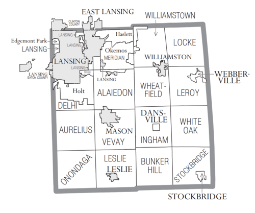
Cities
- East Lansing (part)
- Lansing (part)
- Leslie
- Mason (county seat)
- Williamston
Villages
Charter townships
Civil townships
Census-designated places
Other unincorporated communities
- Columbia
- Fitchburg
- Onondaga
Education
- School districts include
- [12]
- Dansville Schools
- East Lansing School District
- Eaton Rapids Public Schools
- Fowlerville Community Schools
- Haslett Public Schools
- Holt Public Schools
- Lansing Public School District
- Leslie Public Schools
- Mason Public Schools
- Morrice Area Schools
- Northwest School District
- Okemos Public Schools
- Perry Public School District
- Springport Public Schools
- Stockbridge Community Schools
- Waverly Community Schools
- Webberville Community Schools
- Williamston Community Schools
The Michigan School for the Blind, a state-operated school, was formerly in Lansing.
Michigan State University is in the county.
See also
- List of Michigan State Historic Sites in Ingham County, Michigan
- National Register of Historic Places listings in Ingham County, Michigan
References
- "Bibliography on Ingham County". Clarke Historical Library, Central Michigan University. Retrieved January 19, 2013.
- "State & County QuickFacts". United States Census Bureau. Retrieved September 15, 2021.
- "Find a County". National Association of Counties. Archived from the original on May 31, 2011. Retrieved June 7, 2011.
- "2010 Census Gazetteer Files". United States Census Bureau. August 22, 2012. Archived from the original on November 13, 2013. Retrieved September 25, 2014.
- "Hiking Trails, Mountain Bike Trails & Trail Maps - Trails.com". mountainzone.com.
- "U.S. Decennial Census". United States Census Bureau. Retrieved September 25, 2014.
- "Historical Census Browser". University of Virginia Library. Retrieved September 25, 2014.
- "Population of Counties by Decennial Census: 1900 to 1990". United States Census Bureau. Retrieved September 25, 2014.
- "Census 2000 PHC-T-4. Ranking Tables for Counties: 1990 and 2000" (PDF). United States Census Bureau. Retrieved September 25, 2014.
- "U.S. Census website". United States Census Bureau. Retrieved January 31, 2008.
- Leip, David. "Dave Leip's Atlas of U.S. Presidential Elections". uselectionatlas.org. Retrieved April 3, 2018.
- "2020 CENSUS - SCHOOL DISTRICT REFERENCE MAP: Ingham County, MI" (PDF). U.S. Census Bureau. Retrieved July 20, 2022. - Text list
External links
- Ingham County
- Capital Area District Library (serving all of Ingham County except East Lansing)
- "Bibliography on Ingham County". Clarke Historical Library, Central Michigan University. Retrieved January 19, 2013.
Places adjacent to Ingham County, Michigan | ||||||||||||||||
|---|---|---|---|---|---|---|---|---|---|---|---|---|---|---|---|---|
| ||||||||||||||||
Municipalities and communities of Ingham County, Michigan, United States | ||
|---|---|---|
County seat: Mason | ||
| Cities | 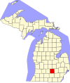 | |
| Villages | ||
| Charter townships | ||
| Civil townships | ||
| CDPs | ||
| Other unincorporated communities |
| |
| Footnotes | ‡This populated place also has portions in an adjacent county or counties | |
| ||
Central/Mid-Michigan including the Tri-Cities and Thumb | |||||||
|---|---|---|---|---|---|---|---|
| Central cities | |||||||
| Counties |
| ||||||
| Geography | |||||||
| Transportation |
| ||||||
| Economy |
| ||||||
| |||||||
Authority control | |
|---|---|
| General | |
| National libraries | |
| Other |
|
На других языках
[de] Ingham County
Ingham County[3] ist ein County im Bundesstaat Michigan der Vereinigten Staaten. Der Verwaltungssitz (County Seat) ist Mason.- [en] Ingham County, Michigan
[ru] Ингем (округ)
Округ Ингем (англ. Ingham County) располагается в штате Мичиган, США. Официально образован 29-го октября 1829 года. По состоянию на 2010 год, численность населения составляла 280 895 человек.Другой контент может иметь иную лицензию. Перед использованием материалов сайта WikiSort.org внимательно изучите правила лицензирования конкретных элементов наполнения сайта.
WikiSort.org - проект по пересортировке и дополнению контента Википедии