world.wikisort.org - USA
Ontonagon County (/ˌɒntəˈnɑːɡən/ ON-tə-NAH-gən) is a county in the Upper Peninsula of the U.S. state of Michigan. As of the 2020 Census, the population was 5,816,[3] making it Michigan's third-least populous county. The county seat is Ontonagon.[4] The county was set off in 1843, and organized in 1848.[1] Its territory had been organized as part of Chippewa and Mackinac counties. With increasing population in the area, more counties were organized. After Ontonagon was organized, it was split to create Gogebic County.[1][5] It is also the westernmost U.S. county that uses the Eastern Time Zone.
Ontonagon County | |
|---|---|
U.S. county | |
 Ontonagon County Courthouse | |
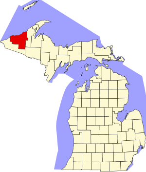 Location within the U.S. state of Michigan | |
 Michigan's location within the U.S. | |
| Coordinates: 46°59′N 89°16′W | |
| Country | |
| State | |
| Founded | March 9, 1843 1848 organized[1][2] |
| Named for | Ontonagon River |
| Seat | Ontonagon |
| Largest village | Ontonagon |
| Area | |
| • Total | 3,741 sq mi (9,690 km2) |
| • Land | 1,311 sq mi (3,400 km2) |
| • Water | 2,430 sq mi (6,300 km2) 65%% |
| Population (2020) | |
| • Total | 5,816 |
| • Density | 5.2/sq mi (2.0/km2) |
| Time zone | UTC−5 (Eastern) |
| • Summer (DST) | UTC−4 (EDT) |
| Congressional district | 1st |
| Website | http://ontonagoncounty.org/ |
The county is named after the Ontonagon River. The name is said to be loosely derived from an Ojibwe language word noojitoon ziibi, meaning "hunting river."[1] A French transliteration, Nantounagon, identified the river on a 1670 French map. Alternatively, and perhaps more accurately, it is said to be derived from the Ojibwa onagon, which means "dish" or "bowl."[6] See List of Michigan county name etymologies.
Geography
According to the US Census Bureau, the county has a total area of 3,741 square miles (9,690 km2), of which 1,311 square miles (3,400 km2) is land and 2,430 square miles (6,300 km2) (65%) is water.[7] It is the third-largest county in Michigan by area.
At a longitude of 89.5°W, it is the westernmost county in the United States contained entirely within the Eastern Time Zone.
Geographic features
- Lake of the Clouds
- Lake Superior
- Lake Gogebic is the largest lake in the Upper Peninsula.
- Corpse Pond
- Ontonagon River
- Firesteel River
- Flintsteel River
- Halfway Creek
- Townline Creek
- Maple Leaf Creek
Major highways
 US 45 – runs north–south through east-central part of county. Enters south line from Watersmeet, passes Paulding, Bruce Crossing, and Rockland, ending at Ontonagon.
 M-26 – enters east line of county at 12 miles (19 km) south of NE county corner. Runs SW, passing Mass City and Lake Mine, to intersection with M-38 east of Rockland.
 M-28 – runs east–west thru southern part of county. Enters 10.4 miles (16.6 km) north of SE county corner. Runs westerly into Gogebic County.
 M-38 – enters east line of county at a point east of Mass City. Runs west to Lake Mine, then WNW to terminus at Ontonagon.
 M-64 – runs north–south through center part of county. Enters south line on west side of Lake Gogebic; runs north to Lake Superior shoreline. Runs NE along shoreline to terminus at Ontonagon.[8]
Airport
Ontonagon County Airport (KOGM) serves the county and surrounding communities.
Adjacent counties
- Keweenaw County – northeast
- Houghton County – east
- Iron County – southeast/CST Border
- Gogebic County – south/CST Border
- Ashland County, Wisconsin – west/CST Border
- Cook County, Minnesota – northwest/CST Border
National protected areas
- Keweenaw National Historical Park (part)
- Ottawa National Forest (part)
Demographics
| Historical population | |||
|---|---|---|---|
| Census | Pop. | %± | |
| 1850 | 389 | — | |
| 1860 | 4,568 | 1,074.3% | |
| 1870 | 2,845 | −37.7% | |
| 1880 | 2,565 | −9.8% | |
| 1890 | 3,756 | 46.4% | |
| 1900 | 6,197 | 65.0% | |
| 1910 | 8,650 | 39.6% | |
| 1920 | 12,428 | 43.7% | |
| 1930 | 11,114 | −10.6% | |
| 1940 | 11,359 | 2.2% | |
| 1950 | 10,282 | −9.5% | |
| 1960 | 10,584 | 2.9% | |
| 1970 | 10,548 | −0.3% | |
| 1980 | 9,861 | −6.5% | |
| 1990 | 8,854 | −10.2% | |
| 2000 | 7,818 | −11.7% | |
| 2010 | 6,780 | −13.3% | |
| 2020 | 5,816 | −14.2% | |
| US Decennial Census[9] 1790-1960[10] 1900-1990[11] 1990-2000[12] 2010-2018[3] | |||
The 2010 United States Census[13] indicates Ontonagon County had a population of 6,780. This decrease of 1038 people from the 2000 United States Census represents a -13.3% change in population. In 2010 there were 3,258 households and 1,954 families in the county. The population density was 6 people per square mile (2/km2). There were 5,672 housing units at an average density of 4 per square mile (2/km2). 97.3% of the population were White, 1.1% Native American, 0.2% Asian, 0.1% Black or African American, 0.1% of some other race and 1.3% of two or more races. 0.9% were Hispanic or Latino (of any race).
There were 3,258 households, out of which 15.8% had children under the age of 18 living with them, 50.3% were married couples living together, 6.0% had a female householder with no husband present, and 40.0% were non-families. 34.8% of all households were made up of individuals, and 17.0% had someone living alone who was 65 years of age or older. The average household size was 2.06 and the average family size was 2.61.
The county population contained 15.8% under the age of 18, 4.1% from 18 to 24, 16.7% from 25 to 44, 37.0% from 45 to 64, and 26.3% who were 65 years of age or older. The median age was 52.7 years. The population is 51.6% male and 48.4% female.
The median income for a household in the county was $34,786, and the median income for a family was $46,845. The per capita income for the county was $22,195. About 9.0% of families and 14.3% of the population were below the poverty line, including 22.2% of those under age 18 and 6.7% of those age 65 or over.
History
In 1843, Michigan's Upper Peninsula was divided into Mackinac, Chippewa, Marquette, Schoolcraft, Delta, and Ontonagon Counties. In 1845, a portion of Ontonagon County was partitioned to be part of Houghton County.[14] In 1846, the village of Ontonagon was named as the county seat of Ontonagon County.[15]
Government
Ontonagon County is fairly balanced to Republican-leaning. Since 1876 its voters have selected the Republican Party nominee in 62% (23 of 37) of the national elections through 2020.
| Year | Republican | Democratic | Third party | |||
|---|---|---|---|---|---|---|
| No. | % | No. | % | No. | % | |
| 2020 | 2,358 | 61.89% | 1,391 | 36.51% | 61 | 1.60% |
| 2016 | 2,066 | 60.18% | 1,176 | 34.26% | 191 | 5.56% |
| 2012 | 1,906 | 53.86% | 1,586 | 44.81% | 47 | 1.33% |
| 2008 | 1,823 | 46.92% | 1,966 | 50.60% | 96 | 2.47% |
| 2004 | 2,262 | 53.96% | 1,863 | 44.44% | 67 | 1.60% |
| 2000 | 2,472 | 59.55% | 1,514 | 36.47% | 165 | 3.97% |
| 1996 | 1,523 | 35.86% | 2,080 | 48.98% | 644 | 15.16% |
| 1992 | 1,463 | 30.83% | 2,451 | 51.65% | 831 | 17.51% |
| 1988 | 2,023 | 44.34% | 2,517 | 55.17% | 22 | 0.48% |
| 1984 | 2,464 | 50.95% | 2,350 | 48.59% | 22 | 0.45% |
| 1980 | 2,569 | 48.95% | 2,375 | 45.26% | 304 | 5.79% |
| 1976 | 2,462 | 43.91% | 3,104 | 55.36% | 41 | 0.73% |
| 1972 | 3,040 | 57.51% | 2,140 | 40.48% | 106 | 2.01% |
| 1968 | 2,290 | 45.72% | 2,462 | 49.15% | 257 | 5.13% |
| 1964 | 1,658 | 32.19% | 3,485 | 67.67% | 7 | 0.14% |
| 1960 | 2,620 | 50.63% | 2,553 | 49.33% | 2 | 0.04% |
| 1956 | 2,976 | 57.73% | 2,175 | 42.19% | 4 | 0.08% |
| 1952 | 2,961 | 57.39% | 2,134 | 41.36% | 64 | 1.24% |
| 1948 | 2,561 | 50.18% | 2,163 | 42.38% | 380 | 7.45% |
| 1944 | 2,433 | 48.07% | 2,611 | 51.59% | 17 | 0.34% |
| 1940 | 2,880 | 47.09% | 3,103 | 50.74% | 133 | 2.17% |
| 1936 | 2,162 | 38.86% | 3,233 | 58.12% | 168 | 3.02% |
| 1932 | 2,287 | 45.53% | 2,337 | 46.53% | 399 | 7.94% |
| 1928 | 2,394 | 59.66% | 1,353 | 33.72% | 266 | 6.63% |
| 1924 | 2,249 | 71.42% | 417 | 13.24% | 483 | 15.34% |
| 1920 | 1,977 | 67.71% | 657 | 22.50% | 286 | 9.79% |
| 1916 | 1,235 | 54.29% | 888 | 39.03% | 152 | 6.68% |
| 1912 | 719 | 41.13% | 359 | 20.54% | 670 | 38.33% |
| 1908 | 1,249 | 71.37% | 425 | 24.29% | 76 | 4.34% |
| 1904 | 1,345 | 77.08% | 355 | 20.34% | 45 | 2.58% |
| 1900 | 982 | 68.82% | 429 | 30.06% | 16 | 1.12% |
| 1896 | 757 | 62.77% | 416 | 34.49% | 33 | 2.74% |
| 1892 | 678 | 38.68% | 1,041 | 59.38% | 34 | 1.94% |
| 1888 | 308 | 36.15% | 542 | 63.62% | 2 | 0.23% |
| 1884 | 301 | 53.94% | 233 | 41.76% | 24 | 4.30% |
| 1880 | 228 | 48.31% | 218 | 46.19% | 26 | 5.51% |
| 1876 | 201 | 38.29% | 321 | 61.14% | 3 | 0.57% |
Ontonagon County operates the County jail, maintains rural roads, operates the major local courts, records deeds, mortgages, and vital records, administers public health regulations, and participates with the state in the provision of social services. The county board of commissioners controls the budget and has limited authority to make laws or ordinances. In Michigan, most local government functions – police and fire, building and zoning, tax assessment, street maintenance etc. – are the responsibility of individual cities and townships.
Elected officials
- Prosecuting Attorney: Michael D. Findlay
- Sheriff: Dale Rantala
- County Clerk/Register of Deeds: Stacy C. Preiss
- County Treasurer: Jeanne M. Pollard
- Mine Inspector: Douglas Roberts[17]
As of September 2018
Communities

Village
- Ontonagon (county seat)
Civil townships
- Bergland Township
- Bohemia Township
- Carp Lake Township
- Greenland Township
- Haight Township
- Interior Township
- Matchwood Township
- McMillan Township
- Ontonagon Township
- Rockland Township
- Stannard Township
Census-designated places
- Bergland
- Bruce Crossing
- Ewen
- Greenland
- Lake Gogebic
- Mass City
- Rockland
- White Pine
Unincorporated communities
- Agate
- Algonquin
- Calderwood
- Carp Lake
- Craigsmere
- Maple Grove
- Matchwood
- Paulding
- Paynesville
- Robbins
- Trout Creek
- Victoria
Ghost town
- Adventure
Indian reservation
- The Ontonagon Indian Reservation, a branch of the Lake Superior Chippewa, has a reservation in the northeastern section of Ontonagon Township on the shores of Lake Superior. The reservation occupies 3.775 square miles (9.777 km2) of land but recorded no permanent population at the 2010 Census.[18][19]
See also
- List of Michigan State Historic Sites in Ontonagon County, Michigan
- National Register of Historic Places listings in Ontonagon County, Michigan
- Copper Country
References
- "Bibliography on Ontonagon County". Clarke Historical Library, Central Michigan University. Retrieved June 29, 2013.
- History :: Houghton County, Michigan Archived January 21, 2011, at the Wayback Machine
- "State & County QuickFacts". US Census Bureau. Retrieved September 15, 2021.
- "Find a County". National Association of Counties. Retrieved June 7, 2011.
- My Michigan, Ontonagon genealogy Archived June 28, 2008, at the Wayback Machine
- "Michigan Counties" from the Michigan Department of History, Arts and Libraries. Archived July 28, 2009, at the Wayback Machine
- "2010 Census Gazetteer Files". US Census Bureau. August 22, 2012. Archived from the original on November 13, 2013. Retrieved September 27, 2014.
- Ontonagon County MI Google Maps (accessed September 29, 2018)
- "US Decennial Census". US Census Bureau. Retrieved September 27, 2014.
- "Historical Census Browser". University of Virginia Library. Retrieved September 27, 2014.
- "Population of Counties by Decennial Census: 1900 to 1990". US Census Bureau. Retrieved September 27, 2014.
- "Census 2000 PHC-T-4. Ranking Tables for Counties: 1990 and 2000" (PDF). US Census Bureau. Retrieved September 27, 2014.
- "U.S. Census website". Retrieved June 5, 2013.
- Sawyer, p. 466
- Sawyer, pp. 498-9
- US Election Atlas
- Ontonagon County - Offices
- Archived 2020-02-13 at archive.today United States Census Bureau
- "Michigan: 2010 Population and Housing Unit Counts 2010 Census of Population and Housing" (PDF). 2010 United States Census. United States Census Bureau. September 2012. p. Michigan E-5. Retrieved April 8, 2020.
- Sawyer, Alvah Littlefield (1911). A History of the Northern Peninsula of Michigan and Its People. Lewis Publishing Co. p. 466.
External links
Places adjacent to Ontonagon County, Michigan | ||||||||||||||||
|---|---|---|---|---|---|---|---|---|---|---|---|---|---|---|---|---|
| ||||||||||||||||
Municipalities and communities of Ontonagon County, Michigan, United States | ||
|---|---|---|
County seat: Ontonagon | ||
| Village |
|  |
| Civil townships | ||
| CDPs |
| |
| Other communities | ||
| Ghost town |
| |
| Indian reservation |
| |
| ||
Upper Peninsula of Michigan | |
|---|---|
| Central cities |
|
| Counties | |
| Geography |
|
| Transportation |
|
| Economy |
|
| |
Lansing (capital) | ||
| Topics |
|  |
| Society |
| |
| Regions |
| |
| Largest municipalities |
| |
| Counties |
| |
Authority control | |
|---|---|
| General | |
| National libraries | |
| Other | |
На других языках
- [en] Ontonagon County, Michigan
[ru] Онтонагон (округ)
Округ Онтонагон (англ. Ontonagon County) располагается в штате Мичиган, США. Официально образован 9-го марта 1843 года. По состоянию на 2010 год, численность населения составляла 6 780 человек.Другой контент может иметь иную лицензию. Перед использованием материалов сайта WikiSort.org внимательно изучите правила лицензирования конкретных элементов наполнения сайта.
WikiSort.org - проект по пересортировке и дополнению контента Википедии