world.wikisort.org - USA
Sterling Heights is a city in Macomb County of the U.S. state of Michigan, and one of Detroit's core suburbs. As of the 2020 Census, the city had a total population of 134,346.[4] It is the second largest suburb in Metro Detroit, and the fourth largest city in Michigan.
Sterling Heights, Michigan | |
|---|---|
City | |
| City of Sterling Heights | |
 Sterling Heights City Hall | |
|
| |
| Motto: To Strive on Behalf of All. | |
 Location within Macomb County | |
 Sterling Heights Location within the State of Michigan | |
| Coordinates: 42°34′47″N 83°01′41″W | |
| Country | |
| State | |
| County | |
| Incorporated | 1968 (city) |
| Government | |
| • Type | Council–manager |
| • Mayor | Michael C. Taylor |
| • City manager | Mark D. Vanderpool |
| • City Council | Members
|
| Area | |
| • Total | 36.72 sq mi (95.10 km2) |
| • Land | 36.45 sq mi (94.40 km2) |
| • Water | 0.27 sq mi (0.70 km2) |
| Elevation | 614 ft (187 m) |
| Population (2020) | |
| • Total | 134,346 |
| • Density | 3,686.06/sq mi (1,423.18/km2) |
| Time zone | UTC−5 (Eastern (EST)) |
| • Summer (DST) | UTC−4 (EDT) |
| ZIP code(s) | 48310, 48311, 48312, 48313, 48314 |
| Area code | 586 |
| FIPS code | 26-76460[2] |
| GNIS feature ID | 0638798[3] |
| Website | Official website |
History
As a result of the War of 1812 and the 1817 Treaty of Fort Meigs, the area of Michigan Territory which now makes up Sterling Heights was first surveyed by Deputy Surveyor Joseph Wampler; his survey was approved on February 20, 1818.[5] Wampler had been one of two deputy surveyors of Perrysburg, Ohio, in 1816.
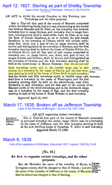
Originally created as part of Shelby Township in April 1827,[6] it was broken off as Jefferson Township in March 1835.[7] In March 1838, it was renamed Sterling Township.[8]
Until the 1950s, Sterling Township was an agricultural area, largely devoted to growing rhubarb and other crops sold in Detroit.[9] Road improvements led to decreased commute times and lower costs for the delivery of goods and services to and from businesses. The population increased when suburban homes were built for the workers in metropolitan Detroit's booming automobile industry. There was already a small village named Sterling in Arenac County. So when Sterling Heights was incorporated as a city in 1968, the word "Heights" was added to the township name to satisfy a state law that prevents incorporated municipalities from having the same name.[10]
Gerald Donovan became the first mayor of the city and F. James Dunlop became the first mayor pro-tem. In the 1960s and 1970s, many residents came to live in Sterling Heights to work in automobile plants operated by Chrysler and Ford. Lakeside Mall opened in Sterling Heights in 1976.
The city is home to many groups of immigrants. It has received many people of eastern European origins, including ethnic Albanians, Bosnians, Croatians, Macedonians, Montenegrins, Poles, Serbians and Slovenians.[11] After the 2003 U.S.-Iraqi War, millions of Iraqi citizens were displaced, particularly Iraqi Christians (Chaldean and Assyrian). Of these, 30,000-50,000 resettled in Sterling Heights, giving parts of the city the nickname "Little Nineveh", especially around 15 Mile Road and Ryan.[12][13]
Geography
- According to the United States Census Bureau, the city has a total area of 36.80 square miles (95.31 km2), of which 36.51 square miles (94.56 km2) is land and 0.29 square miles (0.75 km2) is water.[14]
- Sterling Heights is part of the Clinton River watershed, and branches of the river flow through the city.
Sterling Heights is a second-ring suburb, 16 miles (26 km) from Downtown Detroit. The city's southern border is 6 miles (9.7 km) from Detroit's northern border. The shape of the city is 6 miles (9.7 km) long and 6 miles wide.[11]
Climate
Sterling Heights features a humid continental climate (Köppen: Dfa). Summers are somewhat hot with temperatures exceeding 90 °F (32 °C) on average 8.6 days. Winters are cold, with temperatures not rising above freezing on 39.1 days annually, while dropping to or below 0 °F (−18 °C) on average 1.2 days a year.
| Climate data for Sterling Heights (Eastpointe station) | |||||||||||||
|---|---|---|---|---|---|---|---|---|---|---|---|---|---|
| Month | Jan | Feb | Mar | Apr | May | Jun | Jul | Aug | Sep | Oct | Nov | Dec | Year |
| Average high °C (°F) | 0.4 (32.8) |
2.1 (35.8) |
7.1 (44.7) |
14.6 (58.3) |
20.9 (69.7) |
26.7 (80.0) |
29.0 (84.2) |
27.6 (81.7) |
23.8 (74.8) |
16.8 (62.3) |
9.4 (49.0) |
2.5 (36.5) |
15.1 (59.1) |
| Daily mean °C (°F) | −3.6 (25.5) |
−2.6 (27.3) |
1.7 (35.0) |
8.4 (47.2) |
14.8 (58.6) |
20.5 (68.9) |
22.9 (73.3) |
21.8 (71.3) |
17.7 (63.9) |
11.2 (52.1) |
4.9 (40.8) |
−1.3 (29.7) |
9.7 (49.5) |
| Average low °C (°F) | −7.7 (18.2) |
−7.3 (18.8) |
−3.7 (25.3) |
2.2 (36.0) |
8.6 (47.5) |
14.3 (57.7) |
16.8 (62.3) |
16.0 (60.8) |
11.6 (52.9) |
5.5 (41.9) |
0.3 (32.5) |
−5.1 (22.9) |
4.3 (39.7) |
| Average precipitation mm (inches) | 47 (1.86) |
46 (1.82) |
58 (2.27) |
78 (3.07) |
82 (3.23) |
86 (3.38) |
82 (3.22) |
86 (3.38) |
88 (3.45) |
70 (2.75) |
77 (3.05) |
63 (2.49) |
863 (33.97) |
| Source: NOAA (normals 1981–2010) | |||||||||||||
Neighboring cities/towns
Places adjacent to Sterling Heights, Michigan | ||||||||||||||||
|---|---|---|---|---|---|---|---|---|---|---|---|---|---|---|---|---|
| ||||||||||||||||
Main highways
Sterling Heights sits on two main thoroughfares:
State highways
 M-53 commonly called Van Dyke Avenue or the Van Dyke Freeway (they split in the city, however, and rejoin to its north), which leads north into The Thumb.
 M-59, commonly called Hall Road once the freeway ends—which is the east–west connector from just north of Mount Clemens, through Utica as a surface road, and then becomes a limited access freeway to Pontiac, Michigan, being the main northern connector between Macomb County and Oakland County. In Sterling Heights, large areas are devoted to retail and commercial development (e.g., Lakeside Mall).
Other main roads
- Mound Road is an important north–south artery that runs continuously through the city. Overall, the road starts south in Hamtramck and runs up to 32 Mile Road in Romeo. The road ends briefly at River Bends Park in Shelby Township (becoming Auburn Road), and continues just north of 22 Mile Road.
- East-west travel is mainly on the "mile roads," beginning at 14 Mile Road through 20 Mile Road (M-59). 16 Mile Road, also known as Metro Parkway, is another major "mile road". See Roads and freeways in metropolitan Detroit.
- Utica Road is an important diagonal connector that crisscrosses the city from southeast to northwest, going through the intersection of Dodge Park Road (across from the Sterling Heights city hall) via the first roundabout in Macomb County.
- Dequindre Road is the border between the city of Sterling Heights and the city of Troy. It is also the border between the counties of Macomb and Oakland.
- Hayes Road is the divider between Clinton Township (Between Utica Road and South of M59) and Fraser (Between Masonic and Moravian).
Demographics
| Historical population | |||
|---|---|---|---|
| Census | Pop. | %± | |
| 1940 | 3,648 | — | |
| 1950 | 6,509 | 78.4% | |
| 1960 | 14,622 | 124.6% | |
| 1970 | 61,365 | 319.7% | |
| 1980 | 108,999 | 77.6% | |
| 1990 | 117,810 | 8.1% | |
| 2000 | 124,471 | 5.7% | |
| 2010 | 129,699 | 4.2% | |
| 2020 | 134,346 | 3.6% | |
| U.S. Decennial Census 2018 Estimate[15] | |||
2010 census
As of the census[16] of 2010, there were 129,699 people, 49,451 households, and 34,515 families living in the city. The population density was 3,552.4 inhabitants per square mile (1,371.6/km2). There were 52,190 housing units at an average density of 1,429.5 per square mile (551.9/km2). The racial makeup of the city was 85.1% White, 5.2% African American, 0.2% Native American, 6.7% Asian, 0.5% from other races, and 2.2% from two or more races. Hispanic or Latino of any race were 1.9% of the population.
There were 49,451 households, of which 31.0% had children under the age of 18 living with them, 55.0% were married couples living together, 10.5% had a female householder with no husband present, 4.3% had a male householder with no wife present, and 30.2% were non-families. 26.5% of all households were made up of individuals, and 10.7% had someone living alone who was 65 years of age or older. The average household size was 2.61 and the average family size was 3.20.
The median age in the city was 40.4 years. 21.7% of residents were under the age of 18; 8.8% were between the ages of 18 and 24; 25.8% were from 25 to 44; 28.6% were from 45 to 64; and 15.2% were 65 years of age or older. The gender makeup of the city was 48.5% male and 51.5% female.
2000 census
As of the census[2] of 2000, there were 124,471 people, 46,319 households, and 33,395 families living in the city. The population density was 3,397.0 per square mile (1,311.6/km2). There were 47,547 housing units at an average density of 1,297.6 per square mile (501.0/km2). The racial makeup of the city was 90.70% White, 1.30% African American, 0.21% Native American, 4.92% Asian, 0.04% Pacific Islander, 0.34% from other races, and 2.50% from two or more races. 1.34% of the population were Hispanic or Latino of any race.
Ancestries: Polish (19.0%), German (14.4%), Italian (12.5%), Macedonian (5.7%), English (5.0), Chaldean (20.7%), American/US (4.0%) and Irish(4.0).
In 2000, there were more people in Sterling Heights born in Iraq than any other foreign country. In that year there were 5,059 people in Sterling Heights born in Iraq. The next three largest nations of foreign birth were Macedonia at 1,723, Italy at 1,442 and Poland at 1,427. Now in 2020, there is an estimated 50,000 Chaldeans in the city.[17]
There were 46,319 households, out of which 32.9% had children under the age of 18 living with them, 60.4% were married couples living together, 8.5% had a female householder with no husband present, and 27.9% were non-families. 24.1% of all households were made up of individuals, and 8.5% had someone living alone who was 65 years of age or older. The average household size was 2.66 and the average family size was 3.21.
In the city, the population was spread out, with 24.1% under the age of 18, 8.5% from 18 to 24, 30.4% from 25 to 44, 25.2% from 45 to 64, and 11.8% who were 65 years of age or older. The median age was 37 years. For every 100 females, there were 96.0 males. For every 100 females age 18 and over, there were 92.6 males.
The median income for a household in the city was $60,494, and the median income for a family was $70,140. Males had a median income of $51,207 versus $31,489 for females. The per capita income for the city was $24,958. About 4.0% of families and 5.2% of the population were below the poverty line, including 6.6% of those under age 18 and 7.5% of those age 65 or over.
Law and government
The city has a council-manager form of government. The mayor, along with six other council members, is directly elected to council by the city residents. Prior to 2021, city council and Mayor positions had two-year terms. Following the approval of a ballot proposal in the November 2020 election the positions were changed to be four-year terms starting with the 2021 election cycle. As of January 2021, the Mayor is Michael C. Taylor. Taylor was the Mayor Pro Tem when the current Mayor at the time, Mayor Notte, died while in office in December 2014.[18] The current City Manager, Mark D. Vanderpool, has served as the city manager since 2004. In December 2020, the City Council voted to increase Vanderpool's salary by 23%, making him the third highest-paid city administrator of similar cities in Michigan.[19]
Sterling Heights is located in Michigan's 25th House of Representatives district and Michigan's 30th House of Representatives district, District 25 is represented by Democrat Nate Shannon and District 30 is represented by Republican Diana Farrington, Sterling Heights is located in Michigan's 10th Senate district, represented by Republican Michael D. MacDonald.
Nationally, Sterling Heights is situated in both Michigan's 9th congressional district, represented by Democrat Andy Levin and Michigan's 10th congressional district, represented by Republican Lisa McClain. In the 2016 presidential election Donald Trump won Sterling Heights with 53.9 percent of the vote to Hillary Clinton 41.9 percent. In the 2020 presidential election Donald Trump won Sterling Heights with 55.1 percent to Joe Biden 43.8 percent.
Crime
| Sterling Heights | |
|---|---|
| Crime rates* (2019) | |
| Violent crimes | |
| Homicide | 0 |
| Rape | 18.74 |
| Robbery | 12.75 |
| Aggravated assault | 93.72 |
| Total violent crime | 125.21 |
| Property crimes | |
| Burglary | 68.98 |
| Larceny-theft | 713.77 |
| Arson | 5.25 |
| Total property crime | 854.72 |
Notes *Number of reported crimes per 100,000 population. Source: 2019 FBI Report of Offenses Known to Law Enforcement | |
The Sterling Heights Police Department serves as the main law enforcement agency in the city.
Sterling Height's crime rate for 2018 was 180.38 per 100,000 population, a 2.16% decrease from 2017.[20] Sterling Heights' crime rate is lower than both the Michigan (449 [20]) and United States (381 [20]) averages. Sterling Heights had the fourth lowest crime rate per 100,000 population in 2018, compared to surrounding cities [20] Sterling Heights was beat by Rochester (61.19 [21]), Troy (61.74 [22]), and Fraser (157.25 [23]). Sterling Heights has a lower crime rate than Utica (222.27 [24]), Madison Heights (295.68 [25]), Clinton Township (317.93 [26]) and Warren (509.03 [27]).
Education
Sterling Heights is served by two public school districts: Utica Community Schools, which serves the northern half of the city, and Warren Consolidated Schools, which serves the southern half of the city. Utica operates two high schools in the city, Stevenson High School and Henry Ford II High School, while Warren Consolidated only operates one in Sterling Heights High School. Additionally, Parkway Christian School, a private K-12 Christian school, is also located in the city.
Media
The city of Sterling Heights has three local newspapers, The Macomb Daily with daily and Sunday delivery (owned by the Journal Register Company), the Sterling Heights Sentry (C and G Newspapers), and the Sterling Heights Source (owned by Advisor & Source Newspapers), the last two are delivered to city residences free of charge. The city also has two local channels. SHTV is run by the city's community relations department and usually features locally produced programming (including City Council meetings) and community announcements.[28] Another channel is used for the Sterling Heights Public Library, which usually features educational programs as well as library announcements and important outreach programs for the thriving LGBT community in Sterling Heights. SHTV is found locally on Comcast channel 5, on Wide Open West channel 10 and online. The public library channel is found on Comcast channel 12 and WOW channel 20. The city's official radio station is AM 1700.[29] The city also releases a seasonal magazine and a city calendar free of charge to each city household and business.
WUFL, affiliated with Family Life Radio, is also based in Sterling Heights.
Sister cities
Sister City initiatives give opportunities for the cities' residents to come to know each other's cultures. The initiatives will facilitate the cultural, educational, municipal, business, professional and technical exchanges and projects among the sister cities. Sterling Heights' sister cities are:[30]
 Tetovo, North Macedonia (1982)
 Legazpi, Philippines (1999)
 Cassino, Italy (2006)
- Sorsogon City, Philippines (2008)
- Sant'Elia Fiumerapido, Italy (2010)
 Shëngjin, Albania (2013)
 Jaffna, Sri Lanka (2016)
Notable people
- Tom Jankiewicz, screenwriter; raised in Sterling Heights[31]
- Shawn Hunwick, Retired NHL goaltender
- Greg Pateryn, NHL defenseman
- Craig Krenzel, former NFL player. Krenzel played originally for Ohio State University, winning the National Championship in 2003. He went on to play for the Chicago Bears and Cincinnati Bengals
- Frank Zombo, professional football linebacker for Kansas City Chiefs
- Porcelain Black, industrial pop singer
- Pete Chryplewicz, former football player in the National Football League
- Kalin Lucas, former NBA player[32]
References
- "2020 U.S. Gazetteer Files". United States Census Bureau. Retrieved May 21, 2022.
- "U.S. Census website". United States Census Bureau. Retrieved 2008-01-31.
- "Sterling Heights". Geographic Names Information System. United States Geological Survey, United States Department of the Interior.
- "U.S. Census Bureau QuickFacts: Sterling Heights city, Michigan". Census.gov. Retrieved 2022-07-19.
- "Survey Details - BLM GLO Records". glorecords.blm.gov. Retrieved 2022-05-16.
- "An act to divide the several counties in this Territory into Townships, and for other purposes" - Laws of the Territory of Michigan, Volume 2, Pgs. 478-479
- "An Act organizing certain townships" - Laws of the Territory of Michigan, Volume 3, pgs. 1367-1369
- "An Act to organize certain townships and for other purposes" - Acts of the Michigan Legislature adjourned session of 1837, regular session of 1838; pgs. 76-84
- "Sterling Heights, MI - Official Website". www.sterling-heights.net. Retrieved 2021-01-12.
- Pre-City History Archived 2014-06-28 at the Wayback Machine, The Official Site of the City of Sterling Heights
- Murray, Dublin. "Teen-age strife in Detroit suburb reflects ethnic conflicts of Yugoslavia's civil war." Baltimore Sun. December 22, 1991. p. 1. (Archive). Retrieved on September 28, 2014.
- Thursday, Nicole Rupersburg |; October 06; 2011. "Little Baghdad in Sterling Heights". Metromode. Retrieved 2020-04-25.
{{cite web}}: CS1 maint: numeric names: authors list (link) - Namou, Weam (2019-11-26). "The Story Iraqi-American Author Weam Namou Almost Did Not Tell". Hour Detroit Magazine. Retrieved 2020-04-25.
- "US Gazetteer files 2010". United States Census Bureau. Retrieved 2012-11-25.
- "Population Estimates". United States Census Bureau. Retrieved June 8, 2018.
- "U.S. Census website". United States Census Bureau. Retrieved 2012-11-25.
- [dead link] PCT18. ANCESTRY (TOTAL CATEGORIES TALLIED) FOR PEOPLE WITH ONE OR MORE ANCESTRY CATEGORIES REPORTED [109] - Universe: Total ancestry categories tallied for people with one or more ancestry categories reported, U.S. Census Bureau, 2000 census
- "Sterling Heights, MI - Official Website". www.sterling-heights.net. Retrieved 2021-01-29.
- Hall, Christina. "Sterling Heights city manager gets nearly $38,000 raise". Detroit Free Press. Retrieved 2021-01-29.
- "Sterling Heights MI Crime Rate 2001-2018". www.macrotrends.net. Retrieved 2021-01-29.
- "Rochester MI Crime Rate 1999-2018". www.macrotrends.net. Retrieved 2021-01-29.
- "Troy MI Crime Rate 1999-2018". www.macrotrends.net. Retrieved 2021-01-29.
- "Fraser MI Crime Rate 1999-2018". www.macrotrends.net. Retrieved 2021-01-29.
- "Utica MI Crime Rate 2005-2018". www.macrotrends.net. Retrieved 2021-01-29.
- "Madison Heights MI Crime Rate 1999-2018". www.macrotrends.net. Retrieved 2021-01-29.
- "Clinton Township MI Crime Rate 1999-2018". www.macrotrends.net. Retrieved 2021-01-29.
- "Warren MI Crime Rate 2001-2018". www.macrotrends.net. Retrieved 2021-01-29.
- "SHTV Programs | Sterling Heights, MI - Official Website". www.sterling-heights.net. Retrieved 2021-01-12.
- "Sterling Heights Radio 1700 | Sterling Heights, MI - Official Website". www.sterling-heights.net. Retrieved 2021-01-12.
- "Jaffna becomes a Sister City of Sterling Heights, United States". Daily FT. November 23, 2016. Retrieved November 23, 2016.
- Hinds, Julie (2013-02-02). "'Grosse Pointe Blank' writer Tom Jankiewicz found a place in film history". Detroit Free Press. Retrieved 2013-02-04.
- "'Grounded' Lucas soaring". 3 April 2009.
External links
Municipalities and communities of Macomb County, Michigan, United States | ||
|---|---|---|
County seat: Mt. Clemens | ||
| Cities |  | |
| Villages | ||
| Charter townships | ||
| Civil townships | ||
| Unincorporated communities |
| |
| Footnotes | ‡This populated place also has portions in an adjacent county or counties | |
| ||
Metro Detroit | ||
|---|---|---|
| Topics |
|  |
| Detroit |
| |
| Municipalities over 80,000 | ||
| Municipalities 40,000 to 80,000 | ||
| Cultural enclaves |
| |
| Satellite cities | ||
| Counties in MSA | ||
| Counties in CSA | ||
| ||
Authority control | |
|---|---|
| General | |
| National libraries | |
| Other |
|
На других языках
[de] Sterling Heights (Michigan)
Sterling Heights ist mit 134.346 Einwohnern (Stand 2020) die zweitgrößte Stadt im Macomb County in Michigan, Vereinigte Staaten. Die Schätzung des United States Census Bureaus für 2007 ging von 127.349 Einwohnern aus, was Sterling Heights zur vierteinwohnerreichsten Stadt des Bundesstaates macht. Das Motto der Stadt ist „To Strive on Behalf of All“.- [en] Sterling Heights, Michigan
[ru] Стерлинг-Хайтс
Стерлинг-Хайтс (англ. Sterling Heights) — город, расположенный в округе Макомб штата Мичиган (США) с населением 129 699 человек по данным переписи 2010 года.Другой контент может иметь иную лицензию. Перед использованием материалов сайта WikiSort.org внимательно изучите правила лицензирования конкретных элементов наполнения сайта.
WikiSort.org - проект по пересортировке и дополнению контента Википедии