world.wikisort.org - USA
Port Huron is a city in the U.S. state of Michigan and the county seat of St. Clair County.[4] The population was 30,184 at the 2010 census. The city is adjacent to Port Huron Township but is administered separately.
Port Huron, Michigan | |
|---|---|
City | |
| City of Port Huron | |
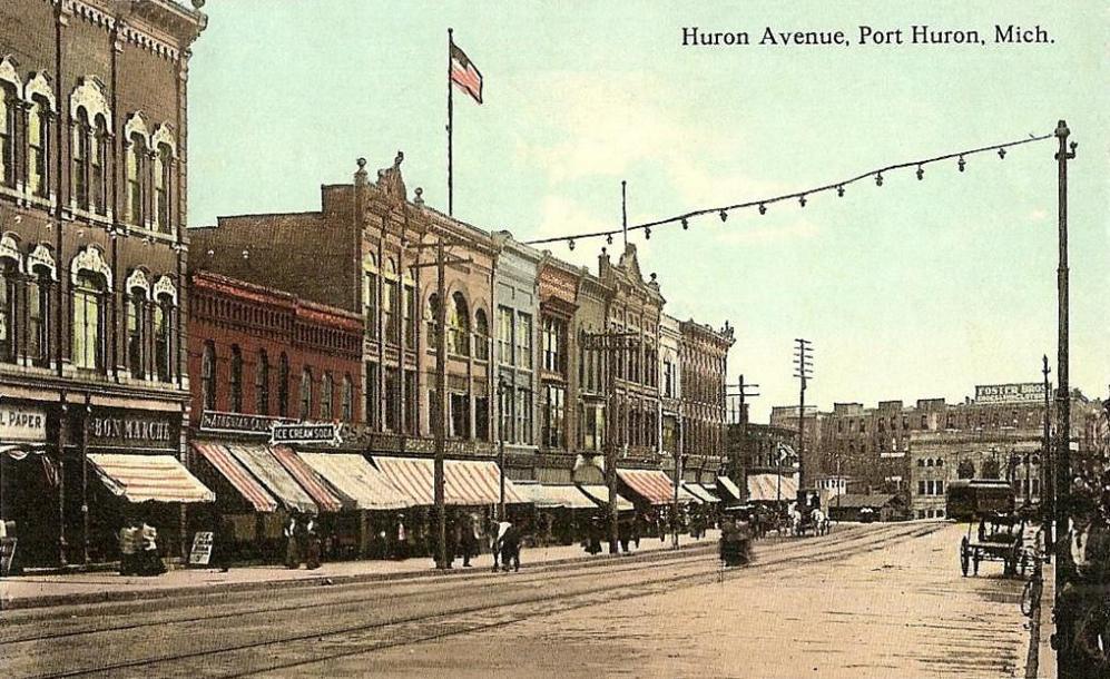
 Looking north along Huron Avenue (BL I-69) | |
| Nickname(s): Maritime Capital of the Great Lakes, Gateway to Canada | |
 Location within St. Clair County | |
 Port Huron Location within the state of Michigan | |
| Coordinates: 42°58′49″N 82°26′15″W | |
| Country | United States |
| State | Michigan |
| County | St. Clair |
| Incorporated | 1857 |
| Government | |
| • Type | Council–manager |
| • Mayor | Pauline Repp |
| • Clerk | Cyndee Jonseck |
| • Manager | James Freed |
| Area | |
| • Total | 12.27 sq mi (31.78 km2) |
| • Land | 8.10 sq mi (20.98 km2) |
| • Water | 4.17 sq mi (10.80 km2) |
| Elevation | 604 ft (184 m) |
| Population (2020) | |
| • Total | 28,983 |
| • Density | 3,577.26/sq mi (1,381.14/km2) |
| Time zone | UTC−5 (Eastern (EST)) |
| • Summer (DST) | UTC−4 (EDT) |
| ZIP code(s) | 48060, 48061 |
| Area code | 810 |
| FIPS code | 26-65820 [2] |
| GNIS feature ID | 1624839 [3] |
| Website | Official website |

Located along the St. Clair River, it is connected to Point Edward, Ontario in Canada via the Blue Water Bridge. The city lies at the southern end of Lake Huron and is the easternmost point on land in Michigan. Port Huron is home to two paper mills, Mueller Brass, and many businesses related to tourism and the automotive industry. The city features a historic downtown area, boardwalk, marina, museum, lighthouse, and the McMorran Place arena and entertainment complex.
History
This area was long occupied by the Ojibwa people. French colonists had a temporary trading post and fort at this site in the 17th century.
In 1814 following the War of 1812, the United States established Fort Gratiot at the base of Lake Huron. A community developed around it. The early 19th century was the first time a settlement developed here with a permanent European-American population. In the 19th century, the United States established an Ojibwa reservation in part of what is now Port Huron, in exchange for their cession of lands under treaty for European-American settlement. But in 1836, under Indian Removal, the US forced the Ojibwa to move west of the Mississippi River and resettle in what are now the states of Wisconsin and Minnesota.[5]
In 1857, Port Huron became incorporated. Its population grew rapidly after the 1850s due a high rate of immigration: workers leaving poverty, famine, and revolutions in Europe were attracted to the successful shipbuilding and lumber industries in Michigan. These industries supported development around the Great Lakes and in the Midwest. In 1859 the city had a total of 4,031 residents; some 1855, or 46%, were foreign-born or their children (first-generation Americans).[6]
By 1870, Port Huron's population exceeded that of surrounding villages. In 1871, the State Supreme Court designated Port Huron as the county seat of St. Clair County.[7]
On October 8, 1871, the city, as well as places north in Sanilac and Huron counties, burned in the Port Huron Fire of 1871. A series of other fires leveled Holland and Manistee, Michigan, as well as Peshtigo, Wisconsin and Chicago, Illinois on the same day. The Thumb Fire that occurred a decade later, also engulfed Port Huron.
In 1895 the village of Fort Gratiot, in the vicinity of the former Fort Gratiot, was annexed by the city of Port Huron.[8]
The following historic sites have been recognized by the State of Michigan through its historic marker program.
- Fort St. Joseph. The fort was built in 1686 by the French explorer Duluth. This fort was the second European settlement in lower Michigan. This post guarded the upper end of the St. Clair River, the vital waterway joining Lake Erie and Lake Huron. Intended by the French to bar English traders from the upper lakes, the fort in 1687 was the base of a garrison of French and Indian allies. In 1688 the French abandoned this fort. The site was incorporated into Fort Gratiot in 1814. A park has been established at the former site of the fort.
- Fort Gratiot Light. The Fort Gratiot Lighthouse was built in 1829 to replace a tower destroyed by a storm. In the 1860s workers extended the tower to its present height of 84 feet (26 m). The light, automated in 1933, continues to guide shipping on Lake Huron into the narrow and swift-flowing St. Clair River. It was the first lighthouse established in the State of Michigan.
- Lightship Huron. From 1935 until 1970, the Huron was stationed in southern Lake Huron to mark dangerous shoals. After 1940 the Huron was the only lightship operating on the Great Lakes. Retired from Coast Guard Service in 1970, she was presented to the City of Port Huron in 1971.
- Grand Trunk Railway Depot. The depot, which is now part of the Port Huron Museum, is where 12-year-old Thomas Edison departed daily on the Port Huron–Detroit run. In 1859, the railroad's first year of operation, Edison convinced the railroad company to let him sell newspapers and confections on the daily trips. He became so successful that he soon placed two newsboys on other Grand Trunks running to Detroit. He made enough money to support himself and to buy chemicals and other experimental materials.
- Port Huron Public Library. In 1902 the city of Port Huron secured money from philanthropist Andrew Carnegie to erect a municipal library and arranged for matching operating funds. In 1904, a grand Beaux-Arts-style structure was built at a cost of $45,000. At its dedication, Melvil Dewey, creator of a widely used book classification system, delivered the opening address. The Port Huron Public Library served in its original capacity for over sixty years. In 1967, a larger public library was constructed. The following year the former library was renovated and re-opened as the Port Huron Museum of Arts and History. An addition was constructed in 1988.
- Harrington Hotel. The hotel opened in 1896 and is a blend of Romanesque, Classical and Queen Anne architecture. The hotel closed in 1986, but a group of investors bought the structure that same year to convert it into housing for senior citizens. The Harrington Hotel is listed on the National Register of Historic Places.
- Grand Trunk Western Railroad Tunnel. The tunnel was opened in 1891 and links Port Huron with Canada. This international submarine railway tunnel was the first international tunnel in the world. The tunnel's total length is 6,025 feet (1,836 m), with 2,290 feet (700 m) underwater. The tunnel operations were electrified in 1908; half a century later they were converted to use diesel fuel. Tracks were lowered in 1949 to accommodate larger freight cars. During World War I, a plot to blast the tunnel was foiled. A new tunnel has since been opened.
The city was hit by a violent F4 tornado on May 21, 1953, damaging or destroying over 400 structures, killing two, and injuring 68.
The city received the All-America City Award in 1955 and 2005.
In June 1962, the Port Huron Statement, a New Left manifesto, was adopted at a convention of the Students for a Democratic Society. The convention did not take place within the actual city limits of Port Huron, but instead was held at a United Auto Workers retreat north of the city (now part of Lakeport State Park).
Port Huron is the only site in Michigan where a lynching of an African-American man took place. On May 27, 1889, in the early morning, a mob of white men stormed the county jail to capture 23-year-old Albert Martin. A mixed-race man, he was accused of attacking a woman. They hanged him from the 7th Street Bridge. A memorial was installed in 2018 at the site, recounting Martin's history. The city collaborated with the Equal Justice Initiative on this memorialization.[9]
Historic photographs
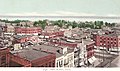 Port Huron circa 1902
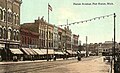 Huron Avenue in 1912
 St. Clair Tunnel in 1907
 Gratiot Lighthouse in 1902
 Fort Gratiot Lighthouse


Geography
According to the United States Census Bureau, the city has a total area of 12.26 square miles (31.75 km2), of which 8.08 square miles (20.93 km2) is land and 4.18 square miles (10.83 km2) is water.[10] The city is considered to be part of the Thumb area of East-Central Michigan, also called the Blue Water Area. The easternmost point (on land) of Michigan can be found in Port Huron, near the site of the Municipal Office Center and the wastewater treatment plant. The Black River divides the city in half, snaking through Port Huron and emptying into the St. Clair River near Downtown.
Climate
Port Huron has a humid continental climate (Köppen climate classification Dfa) with hot summers, cold winters and rain or snow in all months of the year.
| Climate data for Port Huron NOAA Station (1991–2020 normals, extremes 1931–present) | |||||||||||||
|---|---|---|---|---|---|---|---|---|---|---|---|---|---|
| Month | Jan | Feb | Mar | Apr | May | Jun | Jul | Aug | Sep | Oct | Nov | Dec | Year |
| Record high °F (°C) | 64 (18) |
69 (21) |
82 (28) |
87 (31) |
96 (36) |
102 (39) |
103 (39) |
102 (39) |
101 (38) |
90 (32) |
81 (27) |
66 (19) |
103 (39) |
| Average high °F (°C) | 30.9 (−0.6) |
33.3 (0.7) |
42.2 (5.7) |
54.2 (12.3) |
66.7 (19.3) |
76.4 (24.7) |
81.3 (27.4) |
79.7 (26.5) |
73.1 (22.8) |
60.5 (15.8) |
46.9 (8.3) |
36.0 (2.2) |
56.8 (13.8) |
| Daily mean °F (°C) | 25.4 (−3.7) |
26.9 (−2.8) |
35.2 (1.8) |
46.1 (7.8) |
57.7 (14.3) |
67.6 (19.8) |
73.3 (22.9) |
71.8 (22.1) |
65.0 (18.3) |
53.2 (11.8) |
41.0 (5.0) |
31.2 (−0.4) |
49.5 (9.7) |
| Average low °F (°C) | 19.9 (−6.7) |
20.5 (−6.4) |
28.3 (−2.1) |
38.0 (3.3) |
48.8 (9.3) |
58.8 (14.9) |
65.2 (18.4) |
64.0 (17.8) |
56.8 (13.8) |
46.0 (7.8) |
35.2 (1.8) |
26.4 (−3.1) |
42.3 (5.7) |
| Record low °F (°C) | −19 (−28) |
−15 (−26) |
−7 (−22) |
8 (−13) |
21 (−6) |
32 (0) |
35 (2) |
37 (3) |
25 (−4) |
20 (−7) |
2 (−17) |
−7 (−22) |
−19 (−28) |
| Average precipitation inches (mm) | 2.48 (63) |
2.06 (52) |
2.21 (56) |
3.15 (80) |
3.53 (90) |
3.62 (92) |
3.25 (83) |
3.14 (80) |
3.32 (84) |
3.13 (80) |
2.81 (71) |
2.17 (55) |
34.87 (886) |
| Average snowfall inches (cm) | 11.1 (28) |
11.4 (29) |
4.6 (12) |
0.4 (1.0) |
0.0 (0.0) |
0.0 (0.0) |
0.0 (0.0) |
0.0 (0.0) |
0.0 (0.0) |
0.0 (0.0) |
1.3 (3.3) |
6.7 (17) |
35.5 (90) |
| Average precipitation days (≥ 0.01 in) | 14.0 | 10.3 | 10.8 | 12.9 | 13.0 | 10.9 | 10.1 | 10.3 | 10.1 | 12.6 | 11.8 | 12.7 | 139.5 |
| Average snowy days (≥ 0.1 in) | 7.4 | 5.9 | 2.9 | 0.6 | 0.0 | 0.0 | 0.0 | 0.0 | 0.0 | 0.0 | 0.8 | 4.4 | 22.0 |
| Source: NOAA[11][12] | |||||||||||||
Demographics
| Historical population | |||
|---|---|---|---|
| Census | Pop. | %± | |
| 1850 | 1,584 | — | |
| 1860 | 4,371 | 175.9% | |
| 1870 | 5,973 | 36.7% | |
| 1880 | 8,883 | 48.7% | |
| 1890 | 13,543 | 52.5% | |
| 1900 | 19,158 | 41.5% | |
| 1910 | 18,863 | −1.5% | |
| 1920 | 25,944 | 37.5% | |
| 1930 | 31,361 | 20.9% | |
| 1940 | 32,759 | 4.5% | |
| 1950 | 35,725 | 9.1% | |
| 1960 | 36,084 | 1.0% | |
| 1970 | 35,794 | −0.8% | |
| 1980 | 33,981 | −5.1% | |
| 1990 | 33,694 | −0.8% | |
| 2000 | 32,338 | −4.0% | |
| 2010 | 30,184 | −6.7% | |
| 2020 | 28,983 | −4.0% | |
| U.S. Decennial Census[13] | |||
Port Huron is the largest city in the Thumb area, and is a center of industry and trade for the region.
2010 census
As of the census[14] of 2010, there were 30,184 people, 12,177 households, and 7,311 families residing in the city. The population density was 3,735.6 inhabitants per square mile (1,442.3/km2). There were 13,871 housing units at an average density of 1,716.7 per square mile (662.8/km2). The racial makeup of the city was 84.0% White, 9.1% African American, 0.7% Native American, 0.6% Asian, 1.2% from other races, and 4.5% from two or more races. Hispanic or Latino of any race were 5.4% of the population.
There were 12,177 households, of which 32.5% had children under the age of 18 living with them, 34.5% were married couples living together, 19.9% had a female householder with no husband present, 5.6% had a male householder with no wife present, and 40.0% were non-families. 33.0% of all households were made up of individuals, and 11.8% had someone living alone who was 65 years of age or older. The average household size was 2.42 and the average family size was 3.03.
The median age in the city was 35.8 years. 25.6% of residents were under the age of 18; 9.9% were between the ages of 18 and 24; 26.3% were from 25 to 44; 25.2% were from 45 to 64; and 13.1% were 65 years of age or older. The gender makeup of the city was 47.8% male and 52.2% female.
Culture

- There are a number of museums in town. The Port Huron Museum is a series of four museums,[15] namely:
- Carnegie Center (Port Huron Museum)[16]
- Huron Lightship
- Thomas Edison Depot Museum
- Fort Gratiot Lighthouse
- The Great Lakes Maritime Center offers opportunities to learn about the history of the Great Lakes. Freighters pass within 100 feet (30 m) of the glass windows, and there is an underwater live camera feed.
- The Desmond District Demons is a horror film festival, held at the end of October annually. The festival focuses on elevating the horror genre, hosting independent film screenings alongside a Dark Arts Exhibition showcasing local artists.
- The Black River Film Society is a community focused on cultivating the areas independent film screenings and host regular film related events, such as premiering Stockholm (2018 film) in Michigan, Tough Guy: The Bob Probert Story and Sincerely Brenda.
- The School for Strings presents over 50 concerts each year with its Fiddle Club, Faculty, and Student Ensembles. It provides music education across the area.
- Each year, the Port Huron to Mackinac Boat Race is held, with a starting point in Port Huron north of the Blue Water Bridge. The race finishes at Mackinac Island, crossing Lake Huron. It is considered by some boaters to be a companion to the longer Chicago Yacht Club Race to Mackinac.
- The Port Huron Civic Theatre began in 1956 by a group of theater lovers. Since 1983, it has used McMorran Place for its productions.
- The Blue Water Film Festival (2010-2014) was held in the fall, which had notables such as Chris Gore, Sid Haig, Curtis Armstrong, Timothy Busfield, Loni Love, Dave Coulier.
- The main branch of the St. Clair County Library is located in downtown Port Huron. The library contains more than 285,300 books, nearly 200 magazine subscriptions, and over 22,700 books on tape, books on compact disc, music compact discs, cassettes, and videos.
- The International Symphony Orchestra of Sarnia, Ontario and Port Huron, Michigan perform events at McMorran Place, Port Huron Northern Theatre and Temple Baptist Church in Sarnia.
- Encompassing over 100 homes and buildings, the Olde Town Historic District is Port Huron's first and only residential historic district. The Olde Town Historic Neighborhood Association is an organization working to preserve historic architecture in Port Huron. They have hosted an annual historic home tour, flower plantings and beautification and neighborhood Christmas decorations.
- The Welkin Base Ball Club is Port Huron's historic vintage base ball team. Modeled on Port Huron's first baseball club from 1867, the Welkin Base Ball Club re-creates the time of baseball's roots.
Pop culture
A reference to the Port Huron Statement was made in the Coen Brothers film The Big Lebowski.[17]
In 2009 the TV show Criminal Minds used Port Huron, and Detroit as locations for an episode involving crossing the border into Ontario.[18][19]
Sports
Port Huron has had a strong tradition of minor league hockey for many years.
The Port Huron Flags played in the original International Hockey League from 1962 to 1981, winning three Turner Cup championships in 1966, 1971 and 1972. Its leading career scorers were Ken Gribbons, who played most of his career in the IHL; Bob McCammon, a lifelong IHLer who went on to be a National Hockey League coach with the Philadelphia Flyers and the Vancouver Canucks; Bill LeCaine and Larry Gould, who played a handful of NHL games with the Pittsburgh Penguins and the Vancouver Canucks, respectively.
Legendary NHL hockey broadcaster Mike Emrick started his career doing play-by-play hockey for the Flags on AM 1450 WHLS in the mid 1970s. Emrick would go on to broadcast Olympic hockey games and Stanley Cup playoffs for NBC Sports, and is a frequent guest contributor to sister station WPHM.[20]
Port Huron was also represented in the Colonial Hockey League (also operating under the names United Hockey League and International Hockey League), with franchises from 1996 until the league folded in 2010. Originally called the Border Cats, the team was renamed the Beacons in 2002, the Flags in 2005 and the Icehawks in 2007. Among the more notable players were Bob McKillop, Jason Firth, Tab Lardner and Brent Gretzky.
The Port Huron Fighting Falcons of the junior North American Hockey League played at McMorran Place, beginning in 2010 until 2013. The team moved to Connellsville, PA for the 2014 season. The team's name was changed to the Keystone Ice Miners.
Port Huron is also home to the Port Huron Prowlers of the Federal Prospects Hockey League.
The Port Huron Pirates indoor football team dominated the Great Lakes Indoor Football League up until their departure to Flint, MI. McMorran Arena once again hosted indoor football with the Port Huron Predators of the Continental Indoor Football League in 2011. The Predators failed to finish the 2011 season, and were replaced in 2012 by the Port Huron Patriots who also participated in the CIFL.
Parks
The City of Port Huron owns and operates 17 waterfront areas containing 102 acres (0.4 km2) and 3.5 miles (5.6 km) of water frontage. This includes three public beaches and six parks with picnic facilities. The city also has nine scenic turnout sites containing over 250 parking spaces. Port Huron operates the largest municipal marina system in the state and has five separate locations for boat mooring.
The city has 14 public parks, 4 smaller-sized “tot” parks, 19 playgrounds (City owned), 9 playgrounds (School owned), 33 tennis courts, including 16 at schools and 6 indoors, 3 public beaches, 4 public swimming pools, 1 community center, and 1 public parkway.
Government
The city government is organized under a council–manager government form. The City Council is responsible for appointing a city manager, who is the chief administrative officer of the city. The manager supervises the administrative affairs of the city and carries out the policies established by the City Council. As the Chief Administrative Officer, the City Manager is responsible for the organization of the administrative branch and has the power to appoint and remove administrative officers who are responsible for the operation of departments which carry out specific functions. The City Council consists of seven elected officials—a mayor and six council members. Beginning with the 2011 election, citizens voted separately for Mayor and Council. Council members will serve staggered four-year terms and the mayor will serve a two-year term. The current mayor is former city clerk Pauline Repp. The city levies an income tax of 1 percent on residents and 0.5 percent on nonresidents. [21]
Federally, Port Huron is part of Michigan's 10th congressional district, represented by Republican Lisa McClain, elected in 2020.
Education
- High schools
- Port Huron Northern High School
- Port Huron High School
- Harrison Center
- Colleges
- St. Clair County Community College
Economy
Industry
Some of Port Huron's earliest industries, like most Michigan towns, were related to the agriculture industry. A large grain elevator was located on the St. Clair River just north of the current Municipal Office Center.[22] A bean dock was located on the St. Clair River, where dry edible beans from points north in the Thumb were loaded into ships. The dock operated as the Port Huron Terminal Company. Currently the bean dock is used as an event venue.[23] Port Huron was also a national leader in the chicory coffee substitute industry. Future Congressman Henry McMorran in 1902 started Port Huron's chicory processing plant, located on the Black River near 12th Avenue. A second chicory plant operated at 3rd and Court Streets in Port Huron, which would later be purchased by McMorran's son.[24] The roadside weed which grew in areas of the Thumb and Saginaw Valleys was brought to Port Huron for processing and then shipped worldwide. Chicory was commonly used as a coffee substitute especially in wartime.[25]
Wartime also brought another industry to Port Huron: the Mueller Metals Company, which built a factory in Port Huron in 1917. The plant primarily made shell casings for World War I. The factory was originally owned by the Mueller Co., and since has been spun off into its own entity called Mueller Industries.[26] The Port Huron Factory is still in operation, located on Lapeer Road on the city's west side, where they produce a variety of valves and fittings.[27]
The Peerless Cement Company operated a cement plant just south of the Blue Water Bridge from the 1920s through the 1970s. The waterfront site is now the location of the Edison Inn and Blue Water Convention Center.[28]
There are two paper mills in Port Huron. Dunn Paper operates a specialty paper mill at the mouth of the St. Clair River just north of the Blue Water Bridge.[29] Domtar also operates a paper mill in Port Huron, located on the Black River. It was originally built in 1888 by the E. B. Eddy Company. The Domtar mill also specializes in specialty papers for the medical and food service industries.[30] Adjacent to the Domtar Mill is the site of the former Acheson Colloids Company. Dr. Edward Acheson in 1908 founded the company, which made a variety of chemical and carbon-based products.[31] The factory was purchased by Henkel and closed in 2010. However, Henkel continues to manufacture ink and carbon products under the Acheson brand.[32]
A variety of factories related to the automotive industry occupy Port Huron's Industrial Park on the city's south side. Many of these produce plastic components for vehicles.
Shipbuilding
Jenks Shipbuilding Company was founded in 1889, renamed in 1903 as Port Huron Shipbuilding and ceased operations sometime after 1908.[33] The shipyard was found on the north bank of the Black River between Erie Street and Quay Street which is now a parking area for Bowl O Drome and Port Huron Kayak Launch.
Ships built by Jenks includes:
- SS John B. Cowle - bulk freighter 1902
- MS Normac - former fireboat and floating restaurant 1902
Healthcare
Port Huron is served by two acute care facilities, McLaren Port Huron (formerly known as Port Huron Hospital), and Lake Huron Medical Center (formerly known as St. Joseph Mercy Hospital Port Huron).
McLaren Health Care Corporation, a nonprofit managed care health care organization based in Flint, purchased the former Port Huron Hospital and began operating the 186-bed facility as Mclaren Port Huron in May 2014.[34]
Lake Huron Medical Center, is a 144-bed facility operated by Ontario, California based Prime Healthcare Services. The for-profit company purchased the former St. Joseph Mercy Port Huron hospital in September 2015 from Trinity Healthcare.[35] Upon completion of the sale, the formerly non-profit Catholic institution converted to a for-profit entity.
Finance
Port Huron's longtime financial institution was Citizens Federal Bank. The financial institution's headquarters was located in Port Huron with branches throughout the Thumb. The bank's name was changed to Citizens First in 1997.[36] In early 2010, Citizens First was closed by the Michigan Office of Financial and Insurance Regulation. It the first bank in Michigan to fall victim of the financial crisis of 2007–2008. The assets of Citizens First were acquired by First Michigan bank of Troy.[37] First Michigan would be renamed Talmer Bancorp before being purchased by Chemical Financial Corporation (now TCF Financial Corporation) in 2016.
Media
Radio
The first station to sign on in Port Huron was WHLS, coinciding with the opening of the Blue Water Bridge in 1938. It was founded by Harold Leroy Stevens and Fred Knorr. John Wismer became part owner of the station in 1952. He would later launch the first Cable Television system in Port Huron and WSAQ in 1983. Wismer died in 1999.
The Times Herald launched its own radio station in 1947 known as WTTH. That station would later become WPHM, and was bought by Lee Hanson in 1986. WPHM got FM sister station WBTI in 1992. Wismer and Hanson were direct competitors until they were both bought by Bob Liggett's Radio First in 2000.
Radio First owns and operates five radio stations in the region while Port Huron Family Radio is the licensee of sole station WGRT. Non-commercial stations include St. Clair County Regional Education Service Agency's WRSX, high school station WORW, and religious broadcasters WNFA and WNFR.
The following is a list of broadcast radio stations that provide local content to the Port Huron Area. Other stations may be heard area over the air however their content is not directed to residents of the city.
Local FM
|
Local AM
|
Newspaper
- The Times Herald , a daily local newspaper serving St Clair County and Sanilac counties. It is owned by Gannett, which also owns the Detroit Free Press and USA Today.
- Daily editions of the Detroit Free Press and The Detroit News are also available throughout the area.
Broadcast television
St. Clair County lies in the Detroit television market. Channels available on Comcast are as follows:
Detroit Area
|
Southwestern Ontario
St. Clair County also receives the following stations from the Sarnia / London area, but are currently not carried on cable:
|
Transportation

Major highways
Two Interstates terminate at the Port Huron-to-Sarnia Blue Water Bridge, and they meet Highway 402.
 I-69 enters the area from the west, coming from Lansing and Flint, terminating at the approach to the Blue Water Bridge in Port Huron, along with I-94. On the Canadian side of the border, in Sarnia, Ontario, the route heads easterly designated as Highway 402. (Once fully completed, the mainline of I-69 will span from the U.S.–Mexico border in Brownsville, Texas, to the U.S.–Canada border in Port Huron, Michigan.)
 I-94 enters the Port Huron area from the southwest, having traversed the entire Metro Detroit region, and, along with I-69, terminates at the approach to the Blue Water Bridge in Port Huron. On the Canadian side of the border, in Sarnia, Ontario, the route heads easterly designated as Highway 402.
 BL I-69
 BL I-94
 M-25 follows the Lake Huron/Saginaw Bay shoreline, beginning in Bay City and ending in at junction with I-94/I-69, and BL I-94/BL I-69 on the north side of the city.
 M-29 begins at BL I-94 in Marysville just south of the city and continues southerly.
 M-136 runs west from M-25 to M-19.
Mass transit
The Blue Water Area Transit system,[38] created in 1976, includes eight routes in the Port Huron area. Blue Water Transit operates the Blue Water Trolley, which provides a one-hour tour of various local points of interest. Recently, Blue Water Area Transit received a grant from the state to buy new buses for a route between the Port Huron hub and New Baltimore about 30 miles (48 km) south. Commuters could take an express bus traveling down I-94 and get off at the 23 Mile Road SMART Bus stop. At the same time, another bus will travel down M-25 and M-29 and pick up commuters in Marysville, Saint Clair and Algonac before ending up at the same stop on 23 Mile Road. This new system will help people in St. Clair County travel through Metro Detroit.
Rail
- Amtrak provides intercity passenger rail service on the Blue Water route from Chicago to Port Huron (Amtrak station).
- Two class one freight railroads operate in Port Huron – Canadian National Railway (CN) and CSX Transportation (CSXT) with international connections via the St. Clair Tunnel.
- Via Rail train service from Toronto to Sarnia (part of the Quebec City–Windsor Corridor) is also available; however, this train does not cross the river, requiring passengers to make arrangements for road travel to Port Huron.
Airports
St. Clair County International Airport is a public airport located five miles (8 km) southwest of the central business district.
Notable people
- Edward Goodrich Acheson (1856–1931), inventor of carborundum
- Emma Eliza Bower (1852–1937) physician, club-woman, and newspaper owner, publisher, editor
- Burt D. Cady, politician
- Jack Campbell, hockey player
- Ezra C. Carleton, mayor and congressman
- Robert Hardy Cleland, judge
- Omar D. Conger, senator for Michigan
- Deepchord, electronic music producer
- Thomas Edison (1847-1931), inventor and entrepreneur, moved to Port Huron in 1854
- Elizabeth Farrand, author and librarian
- Shawn Faulkner, football player
- Otto Fetting, religious leader
- Obadiah Gardner, senator for Maine
- Jim Gosger, baseball player
- Dorothy Henry, illustrator, cartoonist, painter
- Bill Hogg, baseball pitcher
- Herbert W. Kalmbach, attorney for President Richard Nixon
- Fred Lamlein, baseball player
- Michael Mallory, author
- Steve Mazur, guitarist
- Robert J. McIntosh, politician and pilot
- Terry McMillan, author
- Henry McMorran, businessman and congressman
- Marko Mitchell, football wide receiver
- Colleen Moore, silent movie era actress
- John Morrow, football center
- Jason Motte, baseball pitcher
- Robert C. Odle, Jr., lawyer
- Clifford Patrick O'Sullivan, judge
- Dick Van Raaphorst, football placekicker
- Kevin Rivers, tech businessman and songwriter
- Frank Secory, baseball player and umpire
- Frederick C. Sherman, admiral
- Annah May Soule (1859-1905), professor at Mount Holyoke College
- Nina Spalding Stevens (1876-1959), museum director
- Sara Stokes, singer
- Dennis Sullivan, mathematician
- John Swainson, (1925–1994), Governor of Michigan and a Justice of the Michigan Supreme Court
- Stephan Thernstrom, professor and author
- Harold Sines Vance, businessman and government official
- Kris Vernarsky, amateur ice hockey player
- Felix Watts, inventor
- Harry Wismer, broadcaster and sports team owner
See also
- Port Huron Statement
- Shipwrecks of the 1913 Great Lakes storm
- Blue Water River Walk
- That Certain Feeling
References
- "2020 U.S. Gazetteer Files". United States Census Bureau. Retrieved May 21, 2022.
- "U.S. Census website". United States Census Bureau. Retrieved 2008-01-31.
- "Port Huron". Geographic Names Information System. United States Geological Survey, United States Department of the Interior.
- "Find a County". National Association of Counties. Archived from the original on 2011-05-31. Retrieved 2011-06-07.
- Helen Hornbeck Tanner. Atlas of Great Lakes Indian History. (Norman: University of Oklahoma Press, 1987) p. 165
- "Population of Port Huron" Archived 2015-04-02 at the Wayback Machine, East Saginaw Courier, 13 October 1859, View 2, Chronicling America, Library of Congress, accessed 5 September 2014
- "History of St. Clair County - Port Huron Township & City". ancestry.com. Archived from the original on 2009-11-11. Retrieved 2009-11-10.
- Walter Romig, Michigan Place Names, p. 204
- Shepard, Liz (April 30, 2018). "Port Huron's past included on lynching memorial". ort Huron Times Herald. Retrieved March 18, 2018.
- "US Gazetteer files 2010". United States Census Bureau. Archived from the original on 2011-02-20. Retrieved 2012-11-25.
- "NowData – NOAA Online Weather Data". National Oceanic and Atmospheric Administration. Retrieved May 4, 2021.
- "Summary of Monthly Normals 1991–2020". National Oceanic and Atmospheric Administration. Archived from the original on May 4, 2021. Retrieved May 4, 2021.
- "Census of Population and Housing". Census.gov. Retrieved June 4, 2015.
- "U.S. Census website". United States Census Bureau. Retrieved 2012-11-25.
- "Port Huron Museum". Archived from the original on 2005-08-24. Retrieved 2005-12-01.
- Carnegie Center, Port Huron Museum Archived 2008-02-18 at the Wayback Machine
- "The Dude, The Port Huron Statement, and The Seattle Seven". mentalfloss.com. 10 January 2011. Archived from the original on 2018-06-15. Retrieved 2018-06-15.
- "To Hell... And Back". 20 May 2009. Archived from the original on 2018-03-27. Retrieved 18 March 2018 – via http://www.imdb.com.
{{cite web}}: External link in|via= - "dira - Entries tagged with criminal minds". dira.dreamwidth.org. Archived from the original on 2018-03-19. Retrieved 18 March 2018.
- "Radio man gives back to the community". thetimesherald.com. Retrieved 18 March 2018.
- Gibbons, Lauren (August 16, 2017). "Michigan State University, city of East Lansing at odds over proposed income tax". MLive Lansing. Mlive Media Group. Archived from the original on 2017-08-16. Retrieved August 16, 2017.
- "Grain Elevator at Port Huron, St. Clair River". dia.org.
- "History". Archived from the original on 2018-06-15. Retrieved 2018-06-15.
- "Memory of roasting chicory lingers". The Times Herald.
- "Port Huron once dominated chicory trade". The Times Herald.
- "Mueller Co. Locations – Mueller Museum". Archived from the original on 2018-06-15. Retrieved 2018-06-15.
- "Mueller Industries - Aluminum forging and brass and lead - free brass forging - Markets Served - Forgings". muellerindustriesipd.com. Archived from the original on 2018-06-15. Retrieved 2018-06-15.
- T. J. Gaffney (2006). Port Huron, 1880-1960. Arcadia Publishing. pp. 50–. ISBN 978-0-7385-4119-8.
- "Dunn Paper - Dunn to Perfection". Archived from the original on 2018-06-15. Retrieved 2018-06-15.
- "Port Huron Mill - Domtar". Domtar.com. Archived from the original on 2018-06-15. Retrieved 2018-06-15.
- "History". Archived from the original on 2018-06-15. Retrieved 2018-06-15.
- http://www.achesonindustries.com/ [bare URL]
- "Jenks Ship Building".
- "Port Huron Hospital becomes McLaren's 12th hospital". crainsdetroit.com. 1 May 2014. Archived from the original on 2018-03-19. Retrieved 18 March 2018.
- "Public forum set on sale of St. Joseph Mercy Port Huron to for-profit chain". crainsdetroit.com. 31 March 2015. Archived from the original on 2015-09-28. Retrieved 18 March 2018.
- "InstitutionHistory". www.ffiec.gov. Archived from the original on 2018-06-24. Retrieved 2018-06-24.
- "Feds close Citizens First Bank". Huron Daily Tribune. 4 May 2010. Archived from the original on 2018-06-24. Retrieved 2018-06-24.
- "Blue Water Area Transit". bwbus.com. Archived from the original on 2006-12-06. Retrieved 2006-12-14.
External links
Surrounding communities
Places adjacent to Port Huron, Michigan | |
|---|---|
Municipalities and communities of St. Clair County, Michigan, United States | ||
|---|---|---|
County seat: Port Huron | ||
| Cities |  | |
| Villages | ||
| Charter townships | ||
| Civil townships | ||
| CDPs |
| |
| Other unincorporated communities |
| |
| Footnotes | ‡This populated place also has portions in an adjacent county or counties | |
| ||
Authority control | |
|---|---|
| General | |
| National libraries | |
| Other |
|
На других языках
[de] Port Huron
Port Huron ist eine Stadt im St. Clair County im Bundesstaat Michigan in den Vereinigten Staaten und auch dessen County Seat. Die City ist der gleichnamigen Township benachbart, aber administrativ selbständig. Im Jahr 2020 hatte die Stadt 28.983 Einwohner.- [en] Port Huron, Michigan
[fr] Port Huron
Port Huron est une ville située dans l’État américain du Michigan. La ville est le siège du comté de Saint Clair. Selon le recensement de 2000, sa population est de 32 338 habitants.[it] Port Huron
Port Huron è un comune degli Stati Uniti d'America, situato nello Stato del Michigan, nella contea di St. Clair, della quale è anche il capoluogo. Si trova dalla parte opposta, rispetto al fiume Saint Clair, del villaggio canadese di Point Edward, al quale è collegato tramite il Blue Water Bridge.[ru] Порт-Гурон
Порт-Гуро́н (также Порт-Хью́рон, англ. Port Huron [pɔrt ˈhyʊərən]) — город с местным самоуправлением (city) в штате Мичиган, США. Административный центр и крупнейший населённый пункт округа Сент-Клэр. Население — 30 184 человека (по переписи 2010 года). Самая восточная точка штата Мичиган, близ границы с Онтарио.Другой контент может иметь иную лицензию. Перед использованием материалов сайта WikiSort.org внимательно изучите правила лицензирования конкретных элементов наполнения сайта.
WikiSort.org - проект по пересортировке и дополнению контента Википедии