world.wikisort.org - USA
Big Rapids is a city in the U.S. state of Michigan. The population was 10,601 at the 2010 census. It is the county seat of Mecosta County.[4] The city is located within Big Rapids Township, but it is politically independent. Big Rapids is home of the main campus of Ferris State University, a four-year public university, well known for its College of Pharmacy and the Michigan College of Optometry, as well as its NCAA Division I hockey team, the Bulldogs, and their Division II football and basketball teams.
Big Rapids, Michigan | |
|---|---|
City | |
 Aerial photograph of Big Rapids in 2009 | |
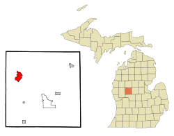 Location of Big Rapids, Michigan | |
 Big Rapids  Big Rapids | |
| Coordinates: 43°41′56″N 85°28′52″W | |
| Country | |
| State | |
| County | Mecosta |
| Area | |
| • Total | 4.56 sq mi (11.82 km2) |
| • Land | 4.45 sq mi (11.51 km2) |
| • Water | 0.12 sq mi (0.30 km2) |
| Elevation | 925 ft (282 m) |
| Population (2020) | |
| • Total | 7,727 |
| • Density | 1,738.36/sq mi (671.13/km2) |
| Time zone | UTC-5 (Eastern (EST)) |
| • Summer (DST) | UTC-4 (EDT) |
| ZIP code | 49307 |
| Area code | 231 |
| FIPS code | 26-08300[2] |
| GNIS feature ID | 1619197[3] |
| Website | cityofbr |
History
Big Rapids was settled in 1855 by brothers George and Zera French. It became the seat of Mecosta County in 1859. The village was platted in 1859. It was incorporated as a city in 1869.[5]
Geography
According to the United States Census Bureau, the city has a total area of 4.48 square miles (11.60 km2), of which 4.36 square miles (11.29 km2) is land and 0.12 square miles (0.31 km2) is water.[6] Like most of the central Michigan area, it lies on the ancient sea bed and has a sandy subsoil which lies above an iron ore base. The Muskegon River runs through Big Rapids, passing both Ferris State University and the local middle school on its way to Lake Michigan. Numerous small lakes are within a few miles of the city.
Government
The city levies an income tax of 1 percent on residents and 0.5 percent on nonresidents.[7]
Transportation
Major Highways
 US 131
 Bus. US 131
 M-20
M-20 B-96
B-96
Bus
- Indian Trails provides daily intercity bus service between Grand Rapids and Petoskey, Michigan. The southbound bus stops in Big Rapids at 2:35 pm, and the northbound bus stops in Big Rapids at 6:03 pm.[8] Since August 1, 2014 buses stop in the Save-A-Lot parking lot across the street from the Racquet & Fitness Center.
- Public dial-a-ride bus service is provided by the Big Rapids Dial-A-Ride.
Airports
- Roben-Hood Airport is located two miles (3.2 km) north of the Big Rapids business district provides services to businesses and general aviation throughout the Midwest.
- Gerald R. Ford International Airport is the nearest international airport, located roughly one hour south of Big Rapids near Grand Rapids.
Cycling, Hiking
The Fred Meijer White Pine Trail, a 92-mile (148 km) multi-use trail from Grand Rapids to Cadillac, passes through Big Rapids.
Demographics
| Historical population | |||
|---|---|---|---|
| Census | Pop. | %± | |
| 1870 | 1,237 | — | |
| 1880 | 3,552 | 187.1% | |
| 1890 | 5,303 | 49.3% | |
| 1900 | 4,686 | −11.6% | |
| 1910 | 4,519 | −3.6% | |
| 1920 | 4,558 | 0.9% | |
| 1930 | 4,671 | 2.5% | |
| 1940 | 4,987 | 6.8% | |
| 1950 | 6,736 | 35.1% | |
| 1960 | 8,686 | 28.9% | |
| 1970 | 11,995 | 38.1% | |
| 1980 | 14,361 | 19.7% | |
| 1990 | 12,603 | −12.2% | |
| 2000 | 10,849 | −13.9% | |
| 2010 | 10,601 | −2.3% | |
| 2020 | 7,727 | −27.1% | |
| U.S. Decennial Census[9] | |||
Population decline
Big Rapids population peaked in the 1980s. Since the 1980s Big Rapids has lost over 46% of it population.[2] There are multiple reasons for the decline. One being the decline in enrollment at Ferris State University.[10] Quality of life concerns have also played a role. Mecosta County (like most rural areas)[11] struggles with poor education, lack of high paying jobs, and high rates of substance abuse.[12]
2010 census
As of the census[13] of 2010, there were 10,601 people, 3,330 households, and 1,323 families living in the city. The population density was 2,431.4 inhabitants per square mile (938.8/km2). There were 3,623 housing units at an average density of 831.0 per square mile (320.9/km2). The racial makeup of the city was 88.0% White, 6.8% African American, 0.7% Native American, 1.5% Asian, 0.6% from other races, and 2.5% from two or more races. Hispanic or Latino of any race were 2.4% of the population.
There were 3,330 households, of which 22.2% had children under the age of 18 living with them, 22.9% were married couples living together, 12.7% had a female householder with no husband present, 4.2% had a male householder with no wife present, and 60.3% were non-families. 36.5% of all households were made up of individuals, and 9.8% had someone living alone who was 65 years of age or older. The average household size was 2.22 and the average family size was 2.88.
The median age in the city was 21.8 years. 12.5% of residents were under the age of 18; 54% were between the ages of 18 and 24; 15.9% were from 25 to 44; 11.2% were from 45 to 64; and 6.5% were 65 years of age or older. The gender makeup of the city was 51.0% male and 49.0% female.
2000 census
As of the census[2] of 2000, there were 10,849 people, 3,388 households, and 1,473 families living in the city. The population density was 2,555.5 inhabitants per square mile (986.7/km2). There were 3,654 housing units at an average density of 860.7 per square mile (332.3/km2). The racial makeup of the city was 83.57% White, 10.63% Black, 0.73% Native American, 2.24% Asian, 0.04% Pacific Islander, 0.50% from other races, and 2.30% from two or more races. Hispanic or Latino of any race were 1.83% of the population.
There were 3,388 households, out of which 25.5% had children under the age of 18 living with them, 26.5% were married couples living together, 14.3% had a female householder with no husband present, and 56.5% were non-families. 35.7% of all households were made up of individuals, and 9.8% had someone living alone who was 65 years of age or older. The average household size was 2.26 and the average family size was 2.93.
In the city, the population was spread out, with 15.2% under the age of 18, 51.0% from 18 to 24, 17.3% from 25 to 44, 9.1% from 45 to 64, and 7.4% who were 65 years of age or older. The median age was 22 years. For every 100 females, there were 109.4 males. For every 100 females age 18 and over, there were 110.4 males. Ferris State University has a high number of male students, accounting for this anomaly.
The median income for a household in the city was $20,192, and the median income for a family was $28,629. Males had a median income of $30,341 versus $19,770 for females. The per capita income for the city was $10,719. About 19.2% of families and 35.0% of the population were below the poverty line, including 29.3% of those under age 18 and 11.6% of those age 65 or over.
Climate
This climatic region has large seasonal temperature differences, with warm to hot (and often humid) summers and cold (sometimes severely cold) winters. According to the Köppen Climate Classification system, Big Rapids has a humid continental climate, abbreviated "Dfb" on climate maps.[14]
| Climate data for Big Rapids Water Treatment Plant, Michigan (1991–2020 normals, extremes 1896–present) | |||||||||||||
|---|---|---|---|---|---|---|---|---|---|---|---|---|---|
| Month | Jan | Feb | Mar | Apr | May | Jun | Jul | Aug | Sep | Oct | Nov | Dec | Year |
| Record high °F (°C) | 61 (16) |
64 (18) |
85 (29) |
89 (32) |
93 (34) |
99 (37) |
103 (39) |
101 (38) |
97 (36) |
88 (31) |
76 (24) |
66 (19) |
103 (39) |
| Average high °F (°C) | 28.2 (−2.1) |
31.4 (−0.3) |
42.0 (5.6) |
54.8 (12.7) |
67.6 (19.8) |
77.2 (25.1) |
81.3 (27.4) |
79.0 (26.1) |
71.6 (22.0) |
58.1 (14.5) |
44.1 (6.7) |
33.2 (0.7) |
55.7 (13.2) |
| Daily mean °F (°C) | 20.4 (−6.4) |
21.8 (−5.7) |
30.9 (−0.6) |
42.9 (6.1) |
55.4 (13.0) |
65.1 (18.4) |
69.2 (20.7) |
67.0 (19.4) |
59.3 (15.2) |
47.2 (8.4) |
35.8 (2.1) |
26.3 (−3.2) |
45.1 (7.3) |
| Average low °F (°C) | 12.7 (−10.7) |
12.2 (−11.0) |
19.8 (−6.8) |
30.9 (−0.6) |
43.2 (6.2) |
53.0 (11.7) |
57.1 (13.9) |
55.0 (12.8) |
46.9 (8.3) |
36.3 (2.4) |
27.5 (−2.5) |
19.3 (−7.1) |
34.5 (1.4) |
| Record low °F (°C) | −30 (−34) |
−36 (−38) |
−24 (−31) |
1 (−17) |
20 (−7) |
28 (−2) |
32 (0) |
32 (0) |
16 (−9) |
10 (−12) |
−8 (−22) |
−18 (−28) |
−36 (−38) |
| Average precipitation inches (mm) | 2.43 (62) |
1.97 (50) |
2.57 (65) |
3.95 (100) |
3.76 (96) |
3.36 (85) |
3.48 (88) |
4.24 (108) |
3.02 (77) |
3.76 (96) |
3.05 (77) |
2.33 (59) |
37.92 (963) |
| Average snowfall inches (cm) | 17.8 (45) |
16.0 (41) |
7.7 (20) |
1.5 (3.8) |
0.0 (0.0) |
0.0 (0.0) |
0.0 (0.0) |
0.0 (0.0) |
0.0 (0.0) |
0.2 (0.51) |
3.8 (9.7) |
14.3 (36) |
61.3 (156) |
| Average precipitation days (≥ 0.01 in) | 16.5 | 12.9 | 11.6 | 13.5 | 13.0 | 10.7 | 10.5 | 11.3 | 11.5 | 14.7 | 13.7 | 14.9 | 154.8 |
| Average snowy days (≥ 0.1 in) | 13.8 | 10.0 | 5.1 | 1.4 | 0.0 | 0.0 | 0.0 | 0.0 | 0.0 | 0.2 | 3.4 | 9.8 | 43.7 |
| Source: NOAA[15][16] | |||||||||||||
Notable people
- Matt Borland, NASCAR crew chief
- Justin Currie, NFL player; raised in Big Rapids [17]
- May Erlewine, a musician from Big Rapids
- Ben Hebard Fuller, Major General and Commandant of the Marine Corps; born in Big Rapids
- Clint Hurdle, outfielder with four MLB teams; manager of the Colorado Rockies and Pittsburgh Pirates; born in Big Rapids
- James Hynes, novelist; grew up in Big Rapids
- Tom Shanahan, a sportswriter and author; grew up in Big Rapids.
- Anna Howard Shaw, a leader of the women's suffrage movement in the nineteenth century; lived in Big Rapids as a young woman
- Daisy Tapley, an African American classical singer; born in Big Rapids
Education
- Big Rapids Public Schools
- Crossroads Charter Academy
- Ferris State University
- St. Peter's Lutheran Church and School
- St. Mary's Catholic School
References
- "2020 U.S. Gazetteer Files". United States Census Bureau. Retrieved May 21, 2022.
- "U.S. Census website". United States Census Bureau. Retrieved January 31, 2008.
- "US Board on Geographic Names". United States Geological Survey. October 25, 2007. Retrieved January 31, 2008.
- "Find a County". National Association of Counties. Archived from the original on May 31, 2011. Retrieved June 7, 2011.
- Romig, Walter (1986). Michigan Place Names: The History of the Founding and the Naming of More than Five Thousand Past and Present Michigan Communities. Great Lakes Books. Detroit: Wayne State University Press. p. 61. OCLC 756403524.
- "US Gazetteer files 2010". United States Census Bureau. Archived from the original on January 12, 2012. Retrieved November 25, 2012.
- Gibbons, Lauren (August 16, 2017). "Michigan State University, city of East Lansing at odds over proposed income tax". MLive Lansing. Mlive Media Group. Retrieved August 16, 2017.
- "Grand Rapids–Cadillac–Traverse City–Petoskey" (PDF). Indian Trails. January 15, 2013. Retrieved March 9, 2013.[permanent dead link]
- "Census of Population and Housing". Census.gov. Retrieved June 4, 2015.
- Bussa, Jayson. "New Ferris State president confronts declining enrollment, post-pandemic opportunities". mibiz.com. Retrieved May 26, 2022.
- Porter, Eduardo (December 14, 2018). "The Hard Truths of Trying to 'Save' the Rural Economy". The New York Times. ISSN 0362-4331. Retrieved May 26, 2022.
- Price, Shepard (April 8, 2022). "Stopping the deaths: Here's what Michigan is doing to prevent fentanyl overdoses". Midland Daily News. Retrieved May 26, 2022.
- "U.S. Census website". United States Census Bureau. Retrieved November 25, 2012.
- Climate Summary for Big Rapids, Michigan
- "NowData - NOAA Online Weather Data". National Oceanic and Atmospheric Administration. Retrieved September 4, 2021.
- "Station: Big Rapids WTP, MI". U.S. Climate Normals 2020: U.S. Monthly Climate Normals (1991-2020). National Oceanic and Atmospheric Administration. Retrieved September 4, 2021.
- Harden, Max. "Big Rapids native Justin Currie records first career sack". Big Rapid News. Pioneer. Retrieved May 5, 2021.
External links
- Big Rapids official website
- Big Rapids Convention & Visitors Bureau
- . Encyclopædia Britannica (11th ed.). 1911.
Municipalities and communities of Mecosta County, Michigan, United States | ||
|---|---|---|
County seat: Big Rapids | ||
| City |  | |
| Villages | ||
| Charter townships | ||
| General law townships | ||
| CDPs |
| |
| Other communities |
| |
| ||
Authority control | |
|---|---|
| General | |
| National libraries | |
| Other |
|
На других языках
[de] Big Rapids
Big Rapids ist eine Stadt (City) im US-Bundesstaat Michigan. Big Rapids ist Verwaltungssitz (County Seat) des Mecosta County. Beim Census im Jahr 2020 zählte Big Rapids 7.727 Einwohner.[1]- [en] Big Rapids, Michigan
Другой контент может иметь иную лицензию. Перед использованием материалов сайта WikiSort.org внимательно изучите правила лицензирования конкретных элементов наполнения сайта.
WikiSort.org - проект по пересортировке и дополнению контента Википедии