world.wikisort.org - USA
Marquette County is a county located in the Upper Peninsula of the US state of Michigan. As of the 2020 Census, the population was 66,017.[2] The county seat is Marquette.[3] The county is named for Father Marquette, a Jesuit missionary. It was set off in 1843 and organized in 1851.[1] Marquette County is the largest county in land area in Michigan, and the most populous county in the Upper Peninsula of Michigan.
Marquette County | |
|---|---|
U.S. county | |
 Marquette County Courthouse in Marquette | |
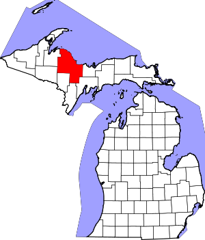 Location within the U.S. state of Michigan | |
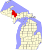
 Michigan's location within the U.S. | |
| Coordinates: 46°40′N 87°36′W | |
| Country | |
| State | |
| Founded | March 9, 1843, organized 1851[1] |
| Named for | Jacques Marquette |
| Seat | Marquette |
| Largest city | Marquette |
| Area | |
| • Total | 3,425 sq mi (8,870 km2) |
| • Land | 1,808 sq mi (4,680 km2) |
| • Water | 1,616 sq mi (4,190 km2) 47%% |
| Population (2020) | |
| • Total | 66,017 |
| • Density | 37/sq mi (14/km2) |
| Time zone | UTC−5 (Eastern) |
| • Summer (DST) | UTC−4 (EDT) |
| Congressional district | 1st |
| Website | www |
Marquette County comprises the Marquette, MI Micropolitan Statistical Area.
Geography
According to the United States Census Bureau, the county has a total area of 3,425 square miles (8,870 km2), of which 1,808 square miles (4,680 km2) is land and 1,616 square miles (4,190 km2) (47%) is water.[4] It is the largest county in Michigan by land area and fourth-largest by total area.
The Huron Mountains are located in the county. To the north of the county is Lake Superior.
Adjacent counties
- Alger County, east
- Delta County, southeast
- Menominee County, south/CT Border
- Dickinson County, south/CT Border
- Iron County, southwest/CT Border
- Baraga County, west
- Houghton County, northwest
- Keweenaw County, north
National protected areas
- Hiawatha National Forest (part)
- Huron National Wildlife Refuge
- Ottawa National Forest (part)
Climate
| ||||||||||||||||||||||||||||||||||||||||||||||||||||||||||||||||||||||||||||||||||||||||||||||||||||||||||||||||||||||||||||
Economy
Top employers
Last updated June 8, 2021.
According to the Lake Superior Community Partnership website,[6] the top employers in the county are:

|
| Public Employer | # of Employees |
|---|---|
| Northern Michigan University | 914 |
| Marquette Area Public Schools | 410 |
| Michigan Department of Corrections | 350 |
| County of Marquette | 251 |
| Negaunee Public Schools | 190 |
| D.J. Jacobetti Home for Veterans | 167 |
| City of Marquette | 185 |
| NICE Community School District | 163 |
| Gwinn Area Community Schools | 140 |
| Ishpeming Public Schools | 104 |
*Bolded values have been updated for 2021.
Transportation
Airports
- Sawyer International Airport, a county-owned public-use facility, twenty miles (32 km) south of Marquette on the site of K.I. Sawyer Air Force Base, which closed 27 years ago in 1995.
Major highways

 US 41
US 41 M-28
M-28 M-35
M-35 M-94
M-94 M-95
M-95 M-553
M-553
In addition to the 169.42 miles (272.66 km) of state highways in the county, the Marquette County Road Commission maintains 283.85 miles (456.81 km) of primary county roads which include County Road 492 (CR 492), and 988.25 miles (1,590.43 km) of secondary county roads. The road commission provides maintenance such as snow removal under contract with the Michigan Department of Transportation for the state trunklines.[7] In 2010, the commission planned to build CR 595.[8] The project was canceled after the permit was denied by the Michigan Department of Environmental Quality and the project funding was diverted.[9]
Demographics
| Historical population | |||
|---|---|---|---|
| Census | Pop. | %± | |
| 1850 | 136 | — | |
| 1860 | 2,821 | 1,974.3% | |
| 1870 | 15,033 | 432.9% | |
| 1880 | 25,394 | 68.9% | |
| 1890 | 39,521 | 55.6% | |
| 1900 | 41,239 | 4.3% | |
| 1910 | 46,739 | 13.3% | |
| 1920 | 45,786 | −2.0% | |
| 1930 | 44,076 | −3.7% | |
| 1940 | 47,144 | 7.0% | |
| 1950 | 47,654 | 1.1% | |
| 1960 | 56,154 | 17.8% | |
| 1970 | 64,686 | 15.2% | |
| 1980 | 74,101 | 14.6% | |
| 1990 | 70,887 | −4.3% | |
| 2000 | 64,634 | −8.8% | |
| 2010 | 67,077 | 3.8% | |
| 2020 | 66,017 | −1.6% | |
| US Decennial Census[10] 1790-1960[11] 1900-1990[12] 1990-2000[13] 2010-2018[2] | |||
The 2010 United States Census,[14] indicates Marquette County had a population of 67,077. This increase of 2,443 people from 2000 represents a growth of 3.8%. In 2010 there were 27,538 households and 16,664 families in the county. The population density was 37 people per square mile (16/km2). There were 34,330 housing units at an average density of 19 per square mile (8/km2). 93.8% of the population were White, 1.7% Native American, 1.7% Black or African American, 0.6% Asian, 0.2% of some other race and 2.0% of two or more races. 1.1% were Hispanic or Latino (of any race). 18.8% were of Finnish, 13.3% German, 10.5% French, French Canadian or Cajun, 9.3% English, 6.8% Italian, 6.2% Irish and 5.8% Swedish ancestry.[15]
There were 27,538 households, out of which 23.4% had children under the age of 18 living with them, 47.8% were married couples living together, 8.6% had a female householder with no husband present, and 39.5% were non-families. 20.4% of all households were made up of individuals, and 10.6% had someone living alone who was 65 years of age or older. The average household size was 2.26 and the average family size was 2.81.
The county population contained 18.7% were under the age of 18, 14.8% from 18 to 24, 23.0% from 25 to 44, 28.9% from 45 to 64, and 14.7% were 65 years of age or older. The median age was 39.4 years. The population is 50.5% male and 49.5% female.
The median income for a household in the county was $46,875, and the median income for a family was $52,083. The per capita income for the county was $22,170. About 6.4% of families and 12.5% of the population were below the poverty line, including 20.3% of those under age 18 and 12.5% of those age 65 or over.
Government
Marquette County was reliably Republican following the American Civil War; its voters went Republican (or Republican-splinter) in every election from 1876 through 1932. However, that shifted in 1936; since then, the Republican nominee has carried the county in only five out of 22 elections through 2020, and it has become the only reliably Democratic county in the Upper Peninsula.
| Year | Republican | Democratic | Third party | |||
|---|---|---|---|---|---|---|
| No. | % | No. | % | No. | % | |
| 2020 | 16,286 | 43.37% | 20,465 | 54.50% | 799 | 2.13% |
| 2016 | 14,646 | 44.09% | 16,042 | 48.29% | 2,530 | 7.62% |
| 2012 | 13,606 | 42.06% | 18,115 | 56.00% | 625 | 1.93% |
| 2008 | 12,906 | 38.80% | 19,635 | 59.03% | 719 | 2.16% |
| 2004 | 14,690 | 45.22% | 17,412 | 53.60% | 386 | 1.19% |
| 2000 | 12,577 | 43.10% | 15,503 | 53.13% | 1,099 | 3.77% |
| 1996 | 8,805 | 32.91% | 15,168 | 56.69% | 2,785 | 10.41% |
| 1992 | 9,665 | 30.56% | 16,038 | 50.71% | 5,926 | 18.74% |
| 1988 | 11,704 | 42.92% | 15,418 | 56.54% | 145 | 0.53% |
| 1984 | 14,196 | 49.98% | 14,074 | 49.55% | 132 | 0.46% |
| 1980 | 13,181 | 44.71% | 13,312 | 45.16% | 2,986 | 10.13% |
| 1976 | 12,984 | 49.34% | 12,837 | 48.78% | 494 | 1.88% |
| 1972 | 13,249 | 52.67% | 11,555 | 45.93% | 353 | 1.40% |
| 1968 | 8,960 | 42.68% | 11,199 | 53.34% | 836 | 3.98% |
| 1964 | 6,615 | 31.96% | 14,045 | 67.86% | 36 | 0.17% |
| 1960 | 10,690 | 48.77% | 11,177 | 51.00% | 50 | 0.23% |
| 1956 | 12,504 | 56.62% | 9,543 | 43.21% | 37 | 0.17% |
| 1952 | 11,618 | 53.65% | 9,949 | 45.94% | 88 | 0.41% |
| 1948 | 8,591 | 45.06% | 10,003 | 52.47% | 470 | 2.47% |
| 1944 | 8,163 | 40.93% | 11,707 | 58.70% | 74 | 0.37% |
| 1940 | 9,034 | 41.10% | 12,854 | 58.48% | 94 | 0.43% |
| 1936 | 7,607 | 38.33% | 11,994 | 60.44% | 243 | 1.22% |
| 1932 | 9,810 | 55.65% | 7,221 | 40.96% | 598 | 3.39% |
| 1928 | 10,879 | 68.81% | 4,716 | 29.83% | 216 | 1.37% |
| 1924 | 9,771 | 70.70% | 845 | 6.11% | 3,204 | 23.18% |
| 1920 | 9,233 | 70.46% | 3,012 | 22.99% | 858 | 6.55% |
| 1916 | 5,263 | 63.18% | 2,625 | 31.51% | 442 | 5.31% |
| 1912 | 2,603 | 33.28% | 997 | 12.75% | 4,222 | 53.98% |
| 1908 | 5,613 | 74.78% | 1,275 | 16.99% | 618 | 8.23% |
| 1904 | 5,654 | 82.94% | 785 | 11.52% | 378 | 5.54% |
| 1900 | 5,235 | 75.52% | 1,471 | 21.22% | 226 | 3.26% |
| 1896 | 5,111 | 70.11% | 1,980 | 27.16% | 199 | 2.73% |
| 1892 | 3,874 | 53.03% | 2,850 | 39.01% | 581 | 7.95% |
| 1888 | 4,512 | 65.76% | 2,105 | 30.68% | 244 | 3.56% |
| 1884 | 4,230 | 73.49% | 1,478 | 25.68% | 48 | 0.83% |
| 1880 | 2,434 | 65.08% | 1,271 | 33.98% | 35 | 0.94% |
| 1876 | 2,308 | 56.88% | 1,750 | 43.12% | 0 | 0.00% |
The county government operates Sawyer International Airport, the jail, maintains rural roads, operates the major local courts, records deeds, mortgages, and vital records, administers public health regulations, and participates with the state in the provision of social services. The county board of commissioners controls the budget and has limited authority to make laws or ordinances. In Michigan, most local government functions—police and fire, building and zoning, tax assessment, street maintenance, etc.—are the responsibility of individual cities and townships.
Elected officials
- County Clerk: Linda Talsma[17]
- County Treasurer: Jacqueline Solomon[18]
- Drain Commissioner: P. Michael Farrell[19]
- Mine Inspector: Steve Bertucci[20]
- Prosecuting Attorney: Matthew J. Wiese[21]
- Register of Deeds: Carla L'Huillier[22]
- Sheriff: Gregory S. Zyburt[23]
Education
Northern Michigan University is a four-year university in Marquette. It was established in 1899.
Historical markers
There are ten historical markers in the county:[24]
- Cliffs Shaft Mine
- Dandelion Cottage
- Father Marquette Park
- First Steam Railroad in Upper Peninsula
- Ishpeming: Historic Ski Center
- Jackson Mine
- Marquette County Courthouse
- Marquette Iron Range
- Northern Michigan University
- Sam Cohodas Lodge / Sam Cohodas
Communities

Cities
- Ishpeming
- Marquette (county seat)
- Negaunee
Charter townships
Civil townships
Census-designated places
- Big Bay
- Gwinn
- Harvey
- K.I. Sawyer
- Michigamme
- Palmer
- Republic
- Trowbridge Park
- West Ishpeming
Other unincorporated communities
- Alder
- Antlers
- Arnold
- Beaver Grove
- Birch
- Brookton Corners
- Carlshend
- Clarksburg
- Dukes
- Eagle Mills
- Empire Iron Mine
- Gordon
- Green Garden
- Greenwood
- Homeier
- Huron Mountain
- Lakewood
- Lawson
- Little Lake
- Maple Grove
- McFarland
- Midway Location
- National Mine
- North Lake
- Northland
- Sand River
- Selma
- Snowville
- South Greenwood
- South Republic
- Suomi Location
- Vick
- Witch Lake
Indian reservations
- The L'Anse Indian Reservation, which is primarily based in Baraga County to the west, has a small portion within Chocolay Township.
- The Sault Tribe of Chippewa Indians, which is headquartered in Sault Ste. Marie in Chippewa County, occupies a very small piece of property within the city limits of Marquette.
See also
- List of Michigan State Historic Sites in Marquette County, Michigan
- National Register of Historic Places listings in Marquette County, Michigan
References
- Clarke Historical Library. "Bibliography on Marquette County". Central Michigan University. Archived from the original on October 30, 2014. Retrieved January 20, 2013.
- "State & County QuickFacts". United States Census Bureau. Retrieved September 15, 2021.
- "Find a County". National Association of Counties. Archived from the original on May 31, 2011. Retrieved June 7, 2011.
- "2010 Census Gazetteer Files". United States Census Bureau. August 22, 2012. Archived from the original on November 13, 2013. Retrieved September 27, 2014.
- "NASA Earth Observations Data Set Index". NASA. Retrieved January 30, 2016.
- "2020/2021 Principal Employers – Marquette County". Lake Superior Community Partnership. Retrieved June 8, 2021.
- "Welcome to the Marquette County Road Commission". Marquette County Road Commission. 2009. Archived from the original on March 27, 2012. Retrieved April 15, 2012.
- McLaren, Noël (October 18, 2010). "County Road 595 Approved for Planning". Upper Michigan's Source. Negaunee, MI: WLUC-TV. Archived from the original on December 27, 2014. Retrieved April 15, 2012.
- Pepin, John (January 4, 2013). "CR 595 Project Killed". The Mining Journal. Marquette, MI. pp. 1A, 8A. ISSN 0898-4964. Archived from the original on April 29, 2014. Retrieved January 4, 2013.
- "US Decennial Census". United States Census Bureau. Retrieved September 27, 2014.
- "Historical Census Browser". University of Virginia Library. Archived from the original on August 11, 2012. Retrieved September 27, 2014.
- "Population of Counties by Decennial Census: 1900 to 1990". United States Census Bureau. Archived from the original on February 15, 2015. Retrieved September 27, 2014.
- "Census 2000 PHC-T-4. Ranking Tables for Counties: 1990 and 2000" (PDF). United States Census Bureau. Archived (PDF) from the original on December 18, 2014. Retrieved September 27, 2014.
- "U.S. Census website". United States Census Bureau. Retrieved June 15, 2013.
- Data Access and Dissemination Systems (DADS). "U.S. Census website". United States Census Bureau.
- Leip, David. "Dave Leip's Atlas of US Presidential Elections". uselectionatlas.org. Archived from the original on March 23, 2018. Retrieved May 6, 2018.
- "Linda Talsma, County Clerk". County of Marquette. n.d. Archived from the original on September 2, 2018. Retrieved October 10, 2018.
- "Marquette County Treasurer". County of Marquette. n.d. Archived from the original on September 2, 2018. Retrieved February 7, 2022.
- "Marquette County Drain Commissioner: P. Michael Farrell". County of Marquette. n.d. Archived from the original on September 2, 2018. Retrieved October 10, 2018.
- "Marquette County Mine Inspector". County of Marquette. n.d. Archived from the original on September 2, 2018. Retrieved February 7, 2022.
- "Prosecutor's Office". County of Marquette. n.d. Archived from the original on September 2, 2018. Retrieved October 10, 2018.
- "Carla L'Huillier, Register of Deeds". County of Marquette. n.d. Archived from the original on September 2, 2018. Retrieved October 10, 2018.
- "Welcome to the Sheriff's Office". County of Marquette. n.d. Archived from the original on September 2, 2018. Retrieved October 10, 2018.
- "Michigan Historical Markers". michmarkers.com. Archived from the original on March 15, 2010. Retrieved April 3, 2008.
External links
Places adjacent to Marquette County, Michigan | ||||||||||||||||
|---|---|---|---|---|---|---|---|---|---|---|---|---|---|---|---|---|
| ||||||||||||||||
Municipalities and communities of Marquette County, Michigan, United States | ||
|---|---|---|
County seat: Marquette | ||
| Cities |
|  |
| Charter townships | ||
| Civil townships | ||
| CDPs |
| |
| Other unincorporated communities | ||
| Indian reservations |
| |
| Footnotes | ‡This populated place also has portions in an adjacent county or counties | |
| ||
| Central cities | |
|---|---|
| Counties | |
| Geography |
|
| Transportation |
|
| Economy |
|
| |
Lansing (capital) | |||||
| Topics |
|  | |||
| Society |
| ||||
| Regions |
| ||||
| Largest municipalities |
| ||||
| Counties |
| ||||
Authority control | |
|---|---|
| General | |
| National libraries | |
| Other |
|
На других языках
[de] Marquette County (Michigan)
Marquette County[3] ist ein County im Bundesstaat Michigan der Vereinigten Staaten. Der Verwaltungssitz (County Seat) ist Marquette.- [en] Marquette County, Michigan
[ru] Маркетт (округ, Мичиган)
Округ Маркетт (англ. Marquette County) располагается в штате Мичиган, США. Официально образован 9-го марта 1843 года. По состоянию на 2010 год, численность населения составляла 67 077 человек.Другой контент может иметь иную лицензию. Перед использованием материалов сайта WikiSort.org внимательно изучите правила лицензирования конкретных элементов наполнения сайта.
WikiSort.org - проект по пересортировке и дополнению контента Википедии