world.wikisort.org - USA
Greenup County is a county located along the Ohio River in the northeastern part of the U.S. state of Kentucky. As of the 2020 census, the population was 35,962.[1] The county was founded in 1803 and named in honor of Christopher Greenup.[2] Its county seat is Greenup.[3] Greenup County is part of the Huntington-Ashland, WV-KY-OH Metropolitan Statistical Area.
Greenup County | |
|---|---|
U.S. county | |
 Greenup County courthouse in Greenup | |
 Location within the U.S. state of Kentucky | |
 Kentucky's location within the U.S. | |
| Coordinates: 38°32′N 82°55′W | |
| Country | |
| State | |
| Founded | 1803 |
| Named for | Christopher Greenup |
| Seat | Greenup |
| Largest city | Flatwoods |
| Area | |
| • Total | 354 sq mi (920 km2) |
| • Land | 344 sq mi (890 km2) |
| • Water | 10 sq mi (30 km2) 2.8% |
| Population (2020) | |
| • Total | 35,962 |
| • Estimate (2021) | 35,649 |
| • Density | 100/sq mi (39/km2) |
| Time zone | UTC−5 (Eastern) |
| • Summer (DST) | UTC−4 (EDT) |
| Congressional district | 4th |
| Website | greenupcounty |
History
Located with its northern border formed by the Ohio River, Greenup County was organized by an act of the General Assembly of Kentucky on December 12, 1803, from Mason County, which included the majority of eastern Kentucky at the time.
Three courthouses have served Greenup County.[4] The first courthouse, built of logs, was replaced by a brick structure in 1811.[5]
Law and government
The current officials of Greenup County are:[6]
- County Judge/Executive: Robert W. Carpenter
- County Commissioner: Tony Quillen
- County Commissioner: Ernest Duty
- County Commissioner: Andrew Imel
- County Attorney: Michael Wilson
- County Coroner: L. Neil Wright
- County Jailer: Mike Worthington
- County Treasurer: Sharon Bates
- County Sheriff: Matt Smith
- County Surveyor: Anthony Keibler
- Property Valuation Administrator: Bobby Hall
- County Clerk: Amanda Hamm
- Circuit Court Clerk: Allen Reed
Greenup County is a part of the 20th Judicial Circuit (general jurisdiction) and the 20th Judicial District (limited jurisdiction) of the Kentucky Court of Justice (the state's unified court system), which includes neighboring Lewis County. The officials in the 20th Judicial Circuit are:[7][8]
- Circuit Court, Division 1 (General/Felony Division): Brian C. McCloud[9]
- Circuit Court, Division 2 (Family Court Division): Jeffrey L. Preston
- Commonwealth's Attorney (felony prosecutor): Melvin C. Leonhart
The judge in the 20th Judicial District is:
- District Court: Paul E. Craft[10]
Misdemeanor criminal cases brought in District Court are prosecuted by the County Attorney's office.
Geography
According to the United States Census Bureau, the county has a total area of 354 square miles (920 km2), of which 344 square miles (890 km2) is land and 10 square miles (26 km2) (2.8%) is water.[11]
Features
Like most eastern Kentucky counties, Greenup County is predominantly made up of rolling hills and valleys. The land in the Ohio River valley is generally flat and mostly populated by industry, commerce and residential development. Beyond this the land gives way to a series of hills and valleys that are representative of the foothills of the Appalachian Mountains. It is relatively sparsely inhabited by farmers. Among these hills, popular fishing spots can be found among the Little Sandy River, Greenbo Lake, and Tygarts Creek. Greenup County's land is still predominantly covered by forest with minimal clear cutting of the old forests.
The soil has long supported a healthy agriculture and livestock industry. Traditionally, this has meant a sizeable tobacco base and cattle ranching. Since the late 20th century, as traditional agriculture products have been dominated by industrial-scale agri-corporations, growth has been seen in non-traditional products such as American Quarter Horses, ostriches, and marijuana.
Major highways

U.S. Highway 23 is the primary route for travel through Greenup County. It enters Greenup County at the southeasternmost point and follows the Ohio River north along the eastern border passing through Russell, Flatwoods, Raceland, Wurtland, Greenup and South Shore. It then exits just west of South Shore crossing the Ohio River via the U.S. Grant Bridge into Portsmouth, Ohio and continuing north towards Columbus, Ohio.
The AA Highway begins at U.S. Highway 23 and connects to U.S. Highway 52 in Ohio via the Jesse Stuart Memorial Bridge. The AA Highway (also known as Route 10) runs west intersecting Route 7 and eventually exiting west into Lewis County. Since its completion in 1995, the AA Highway has allowed Northeastern Kentucky residents to more easily travel to Maysville, Kentucky as well as Northern Kentucky and Cincinnati, Ohio.
The northern terminus of the Industrial Parkway (Kentucky Route 67) ends at U.S. Highway 23 at Wurtland. This highway serves to connect Wurtland and the surrounding towns of Greenup, Flatwoods and the unincorporated area of Argillite to the EastPark industrial park and Interstate 64 in Carter County.
Adjacent counties
- Boyd County (southeast)
- Carter County (southwest)
- Lewis County (west)
- Scioto County, Ohio (north)
- Lawrence County, Ohio (east)
Demographics
| Historical population | |||
|---|---|---|---|
| Census | Pop. | %± | |
| 1810 | 2,369 | — | |
| 1820 | 4,311 | 82.0% | |
| 1830 | 5,852 | 35.7% | |
| 1840 | 6,297 | 7.6% | |
| 1850 | 9,654 | 53.3% | |
| 1860 | 8,760 | −9.3% | |
| 1870 | 11,463 | 30.9% | |
| 1880 | 13,371 | 16.6% | |
| 1890 | 11,911 | −10.9% | |
| 1900 | 15,432 | 29.6% | |
| 1910 | 18,475 | 19.7% | |
| 1920 | 20,062 | 8.6% | |
| 1930 | 24,554 | 22.4% | |
| 1940 | 24,971 | 1.7% | |
| 1950 | 24,887 | −0.3% | |
| 1960 | 29,238 | 17.5% | |
| 1970 | 33,192 | 13.5% | |
| 1980 | 39,132 | 17.9% | |
| 1990 | 36,742 | −6.1% | |
| 2000 | 36,891 | 0.4% | |
| 2010 | 36,910 | 0.1% | |
| 2020 | 35,962 | −2.6% | |
| 2021 (est.) | 35,649 | [12] | −0.9% |
| U.S. Decennial Census[13] 1790-1960[14] 1900-1990[15] 1990-2000[16] 2010-2020[1] | |||
As of the census[17] of 2000, there were 36,891 people, 14,536 households, and 11,032 families residing in the county. The population density was 107 per square mile (41/km2). There were 15,977 housing units at an average density of 46 per square mile (18/km2). The racial makeup of the county was 98.07% White, 0.57% Black or African American, 0.19% Native American, 0.38% Asian, 0.15% from other races, and 0.64% from two or more races. 0.55% of the population were Hispanic or Latino of any race.
There were 14,536 households, out of which 32.00% had children under the age of 18 living with them, 62.30% were married couples living together, 10.40% had a female householder with no husband present, and 24.10% were non-families. 21.70% of all households were made up of individuals, and 10.00% had someone living alone who was 65 years of age or older. The average household size was 2.51 and the average family size was 2.91.
In the county, the population was spread out, with 23.60% under the age of 18, 7.90% from 18 to 24, 27.90% from 25 to 44, 26.00% from 45 to 64, and 14.60% who were 65 years of age or older. The median age was 39 years. For every 100 females there were 92.80 males. For every 100 females age 18 and over, there were 89.30 males.
The median income for a household in the county was $32,142, and the median income for a family was $38,928. Males had a median income of $35,475 versus $21,198 for females. The per capita income for the county was $17,137. About 11.60% of families and 14.10% of the population were below the poverty line, including 18.60% of those under age 18 and 9.90% of those age 65 or over.
Politics
| Year | Republican | Democratic | Third party | |||
|---|---|---|---|---|---|---|
| No. | % | No. | % | No. | % | |
| 2020 | 13,064 | 71.88% | 4,873 | 26.81% | 239 | 1.31% |
| 2016 | 11,546 | 70.93% | 4,146 | 25.47% | 585 | 3.59% |
| 2012 | 8,855 | 58.38% | 6,027 | 39.73% | 286 | 1.89% |
| 2008 | 8,849 | 56.01% | 6,621 | 41.91% | 328 | 2.08% |
| 2004 | 8,696 | 52.91% | 7,630 | 46.43% | 109 | 0.66% |
| 2000 | 7,233 | 49.33% | 7,164 | 48.86% | 266 | 1.81% |
| 1996 | 5,370 | 38.48% | 6,883 | 49.32% | 1,703 | 12.20% |
| 1992 | 4,975 | 34.52% | 7,214 | 50.05% | 2,225 | 15.44% |
| 1988 | 6,559 | 48.38% | 6,956 | 51.31% | 43 | 0.32% |
| 1984 | 7,451 | 51.52% | 6,923 | 47.87% | 88 | 0.61% |
| 1980 | 6,857 | 48.04% | 7,126 | 49.92% | 292 | 2.05% |
| 1976 | 5,062 | 42.14% | 6,880 | 57.27% | 71 | 0.59% |
| 1972 | 6,828 | 59.70% | 4,491 | 39.27% | 118 | 1.03% |
| 1968 | 4,698 | 43.68% | 4,689 | 43.60% | 1,368 | 12.72% |
| 1964 | 4,045 | 37.58% | 6,680 | 62.06% | 39 | 0.36% |
| 1960 | 6,101 | 53.77% | 5,245 | 46.23% | 0 | 0.00% |
| 1956 | 5,464 | 51.85% | 5,045 | 47.87% | 29 | 0.28% |
| 1952 | 4,354 | 47.96% | 4,716 | 51.95% | 8 | 0.09% |
| 1948 | 3,168 | 42.48% | 4,186 | 56.13% | 104 | 1.39% |
| 1944 | 3,718 | 49.30% | 3,821 | 50.66% | 3 | 0.04% |
| 1940 | 4,059 | 45.99% | 4,742 | 53.73% | 24 | 0.27% |
| 1936 | 3,973 | 45.88% | 4,686 | 54.12% | 0 | 0.00% |
| 1932 | 3,422 | 40.30% | 4,963 | 58.44% | 107 | 1.26% |
| 1928 | 4,410 | 64.43% | 2,435 | 35.57% | 0 | 0.00% |
| 1924 | 2,510 | 47.30% | 1,932 | 36.41% | 864 | 16.28% |
| 1920 | 3,111 | 52.17% | 2,754 | 46.18% | 98 | 1.64% |
| 1916 | 1,821 | 48.37% | 1,820 | 48.34% | 124 | 3.29% |
| 1912 | 923 | 28.60% | 1,172 | 36.32% | 1,132 | 35.08% |
Education
Public school districts
- Greenup County School District serves the cities of Greenup, Wurtland, South Shore and rural Greenup County.
- Russell Independent School District serves the cities of Russell, Flatwoods and Bellefonte.
- Raceland-Worthington Independent School District serves the cities of Raceland and Worthington.
Places of interest
- EastPark
- Greenbo Lake State Resort Park
- Raceland Race Course
Alcohol sales
Greenup County is a moist county, meaning that sale of alcohol in the county is prohibited except in certain areas as voted on by the residents of the area, including at least one area where full retail sales are permitted. In the case of Greenup County, alcohol sales are permitted in the following areas:
- The city of Russell has allowed the full retail sale of alcohol since 2014 after allowing, since 2008, by the drink alcohol sales at restaurants which seat at least 100 diners and derive at least 70% of their total sales from food.[19]
- The cities of Greenup, Raceland and South Shore allow full retail sale of alcohol after voters approved local option petitions in 2020.[20]
- The city of Bellefonte has allowed the full retail sale of alcohol since 2017 after allowing, since 2009, the Bellefonte Country Club to sell alcohol by the drink under a provision that allows voters of an otherwise dry precinct to allow alcohol sales at a specific, voter approved, USGA regulation golf course.[21] The status change had no practical effect within the city itself as restaurants (other than the Bellefonte Country Club), gas stations, grocery stores and other businesses that generally sell alcohol are, by local ordinance, prohibited within the city limits of Bellefonte. The change in status allowed the Bellefonte Country Club to receive a "caterer's license" to serve alcohol by the drink at private offsite events, which was not permitted under the previous alcohol status.[22]
- The Hunnewell election precinct in unincorporated Greenup County approved a petition in 2020 allowing the River Bend Golf Course to sell alcohol by the drink under a provision that allows voters of an otherwise dry precinct to allow alcohol sales at a specific, voter approved, USGA regulation golf course.[23]
The sale of alcohol is prohibited in the cities of Flatwoods, Worthington, Wurtland and in all areas of unincorporated Greenup County outside the River Bend Golf Course.
Communities
- Bellefonte
- Flatwoods
- Greenup (county seat)
- Lloyd
- Raceland
- Russell
- South Portsmouth
- South Shore
- Worthington
- Wurtland
Notable people
- Billy Ray Cyrus – singer/actor, son of Ron Cyrus and father of Miley Cyrus
- Ron Cyrus – politician
- Don Gullett – Major League Baseball pitcher
- Herb Roe – mural artist
- John Stephenson – Major League Baseball Catcher
- Jesse Stuart – Kentucky Poet Laureate
- Clint "Hawk" Thomas – baseball player for the New York Black Yankees of the Negro leagues
- Richard Whitt - Newspaper journalist, (The Courier-Journal), 1978 Pulitzer Prize for his reporting on the fire at the Beverly Hills Supper Club fire in Southgate, Kentucky.[24][25][26]
See also
- National Register of Historic Places listings in Greenup County, Kentucky
References
- "State & County QuickFacts". United States Census Bureau. Retrieved July 13, 2022.
- "Greenup County". Archived from the original on July 17, 2019. Retrieved January 30, 2013.
- "Find a County". National Association of Counties. Archived from the original on May 31, 2011. Retrieved June 7, 2011.
- Hogan, Roseann Reinemuth (1992). Kentucky Ancestry: A Guide to Genealogical and Historical Research. Ancestry Publishing. p. 243. ISBN 9780916489496. Retrieved July 26, 2013.
- Federal Writers' Project (1996). The WPA Guide to Kentucky. University Press of Kentucky. p. 234. ISBN 0813108659. Retrieved November 24, 2013.
- "Greenup County Elected Officials". Greenup Country Fiscal Court. Retrieved January 7, 2019.
- Kentucky Court of Justice
- Office of the Attorney General - Commonwealth's and County Attorneys
- It’s official: McCloud Circuit Judge
- A new Craft: Longtime attorney takes oath as District Judge
- "2010 Census Gazetteer Files". United States Census Bureau. August 22, 2012. Archived from the original on August 12, 2014. Retrieved August 14, 2014.
- "Annual Estimates of the Resident Population for Counties: April 1, 2020 to July 1, 2021". Retrieved July 13, 2022.
- "U.S. Decennial Census". United States Census Bureau. Retrieved August 14, 2014.
- "Historical Census Browser". University of Virginia Library. Retrieved August 14, 2014.
- "Population of Counties by Decennial Census: 1900 to 1990". United States Census Bureau. Retrieved August 14, 2014.
- "Census 2000 PHC-T-4. Ranking Tables for Counties: 1990 and 2000" (PDF). United States Census Bureau. Retrieved August 14, 2014.
- "U.S. Census website". United States Census Bureau. Retrieved January 31, 2008.
- Leip, David. "Dave Leip's Atlas of U.S. Presidential Elections". uselectionatlas.org. Retrieved July 1, 2018.
- Russell goes wet for packaged sales.
- Three Greenup Co. cities vote yes for alcohol sales.
- Wet and Dry Counties in Kentucky as of 2/2020
- Bellefonte to consider wet vote.
- Three Greenup Co. cities vote yes for alcohol sales.
- "The 1978 Pulitzer Prize Winner in Local General or Spot News Reporting : Richard Whitt of Louisville Courier-Journal". The Pulitzer Prizes — Columbia University. Retrieved December 18, 2017.
- "Editorial: Richard E. Whitt a reporter who helped change world". The Daily Independent. April 19, 2015. Retrieved December 18, 2017.
- "Richard Whitt, 'redneck journalist,' 64". Institute for Rural Journalism & Community Issues, University of Kentucky. Retrieved December 18, 2017.
External links
- Government website
- The Kentucky Highlands Project
- Detailed Road Map of Greenup County
- Greenup County Tourism and Convention Commission
Municipalities and communities of Greenup County, Kentucky, United States | ||
|---|---|---|
County seat: Greenup | ||
| Cities |  | |
| Unincorporated communities |
| |
| ||
Huntington-Ashland-Ironton metropolitan area | ||
|---|---|---|
| Principal cities | 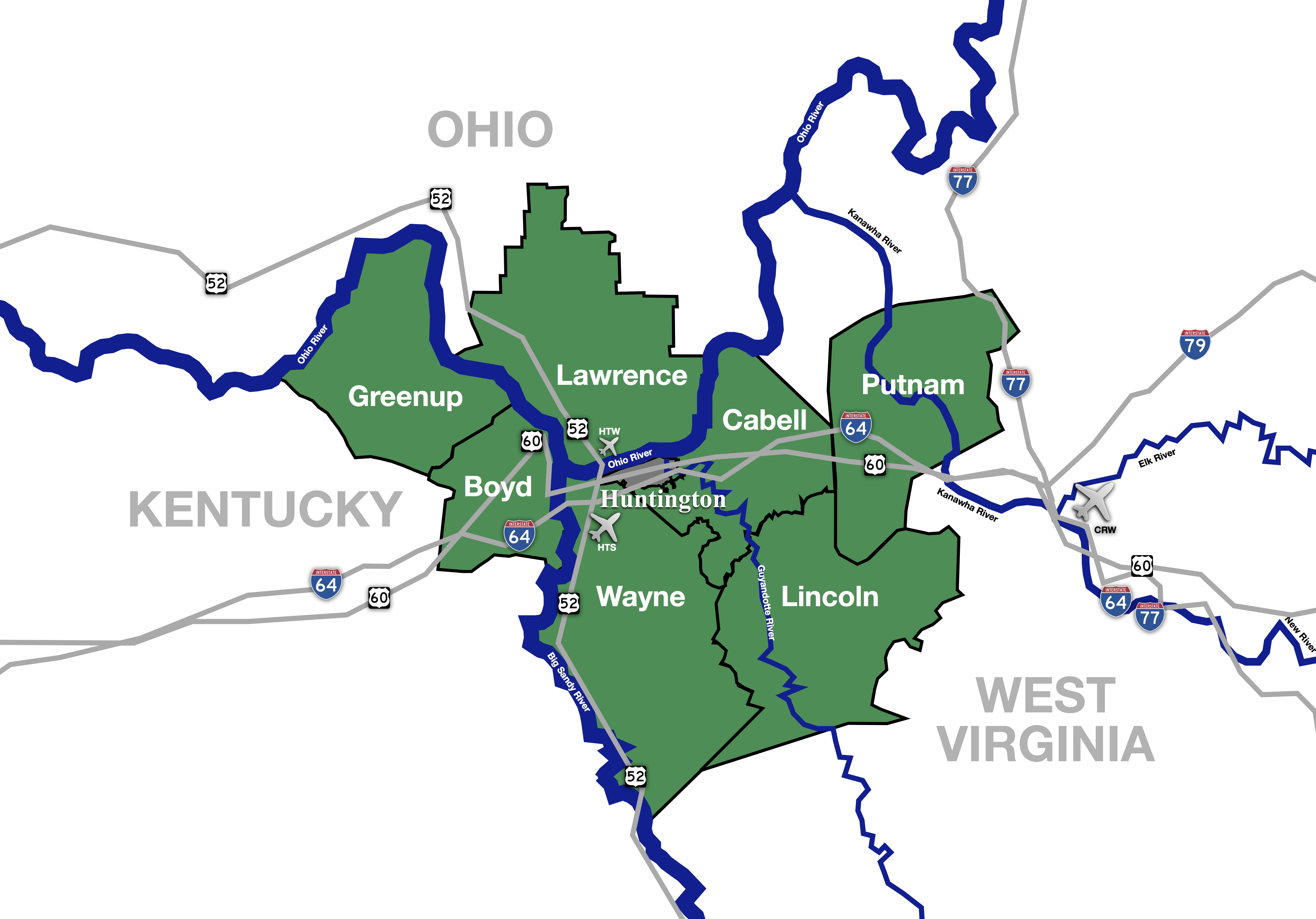 | |
| Municipalities with population over 5,000 | ||
| Municipalities with population 1,000–5,000 | ||
| Municipalities with population under 1,000 | ||
| West Virginia counties | ||
| Kentucky counties | ||
| Ohio counties | ||
Eastern Kentucky Coal Field region | |
|---|---|
| Counties | |
| Cities and towns Over 10k | |
| Cities and towns 5k-10k | |
| Cities and towns 1k-5k | |
| Cities and towns under 1k | |
| Statistical areas |
|
| See also |
|
Authority control | |
|---|---|
| General | |
| Other |
|
На других языках
[de] Greenup County
Greenup County[1] ist ein County im Bundesstaat Kentucky der Vereinigten Staaten. Der Verwaltungssitz (County Seat) ist Greenup. Das County gehört zu den Dry Countys, was bedeutet, dass der Verkauf von Alkohol eingeschränkt oder verboten ist.- [en] Greenup County, Kentucky
[ru] Гринуп (округ)
Гринуп, также Гри́неп[1] (англ. Greenup County) — округ в штате Кентукки, США. Официально образован в 1803 году. По состоянию на 2010 год, численность населения составляла 36 910 человек.Другой контент может иметь иную лицензию. Перед использованием материалов сайта WikiSort.org внимательно изучите правила лицензирования конкретных элементов наполнения сайта.
WikiSort.org - проект по пересортировке и дополнению контента Википедии