world.wikisort.org - USA
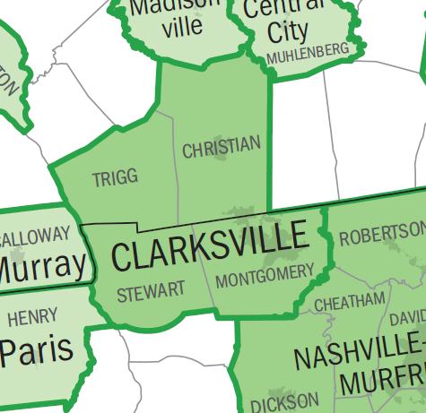
The Clarksville Metropolitan Statistical Area is defined by the United States Census Bureau as an area consisting of four counties – two (Montgomery and Stewart) in Tennessee and two (Christian and Trigg) in Kentucky – anchored by the city of Clarksville, Tennessee. A July 1, 2018 estimate placed the population at 307,820.[1] As of 2009, the Clarksville Metropolitan Statistical Area is the 167th largest MSA in the United States.
Clarksville area | |
|---|---|
Metropolitan statistical area | |
| Clarksville, TN-KY Metropolitan Statistical Area | |
 | |
| Country | United States |
| State(s) | Tennessee, Kentucky |
| Largest city | Clarksville |
| Other cities | - Hopkinsville - Oak Grove - Fort Campbell North - Dover |
| Area | |
| • Total | 2,242 sq mi (5,810 km2) |
| Population (2019) | |
| • Total | 307,820 |
| • Rank | 167th (2009) in the U.S. |
Prior to 2003, the area was officially known as the Clarksville-Hopkinsville Metropolitan Statistical Area and included only Montgomery and Christian counties.[2] In 2003, Hopkinsville was removed from the official name as it was no longer considered a principal city.[3] That year, Stewart and Trigg counties were also added to the MSA.
Counties
- Montgomery County, Tennessee
- Stewart County, Tennessee
- Christian County, Kentucky
- Trigg County, Kentucky
Communities
Places with more than 100,000 inhabitants
- Clarksville, Tennessee (Principal city)
Places with 25,000 to 50,000 inhabitants
Places with 5,000 to 25,000 inhabitants
- Fort Campbell North, Kentucky (census-designated place)
- Oak Grove, Kentucky
Places with 1,000 to 5,000 inhabitants
Places with fewer than 1,000 inhabitants
- Crofton, Kentucky
- Cumberland City, Tennessee
- LaFayette, Kentucky
- Pembroke, Kentucky
Unincorporated places
- Bumpus Mills, Tennessee
- Canton, Kentucky
- Cerulean, Kentucky
- Cunningham, Tennessee
- Dotsonville, Tennessee
- Excell, Tennessee
- Fairview, Christian County, Kentucky
- Fearsville, Kentucky
- Fredonia, Tennessee
- Gracey, Kentucky
- Herndon, Kentucky
- Kelly, Kentucky
- Needmore, Tennessee
- Oakridge, Tennessee
- Oakwood, Tennessee
- Orgains Crossroads, Tennessee
- Palmyra, Tennessee
- Port Royal, Tennessee
- Rockcastle, Kentucky
- Rossview, Tennessee
- Sango, Tennessee
- Southside, Tennessee
- Shiloh, Montgomery County, Tennessee
- Sailors Rest, Tennessee
- Tarsus, Tennessee
- Wallonia, Kentucky
- Woodlawn, Tennessee
Demographics
As of the census[4] of 2000, there were 232,000 people, 83,332 households, and 61,719 families residing within the MSA. The racial makeup of the MSA was 74.16% White, 19.13% African American, 0.51% Native American, 1.43% Asian, 0.23% Pacific Islander, 1.98% from other races, and 2.55% from two or more races. Hispanic or Latino of any race were 4.61% of the population.
The median income for a household in the MSA was $33,869, and the median income for a family was $39,451. Males had a median income of $29,506 versus $21,849 for females. The per capita income for the MSA was $16,341.
See also
- Tennessee census statistical areas
- Kentucky census statistical areas
References
- "Table 1. Annual Estimates of the Population of Metropolitan and Micropolitan Statistical Areas: April 1, 2000 to July 1, 2009 (CBSA-EST2009-01)". 2009 Population Estimates. United States Census Bureau, Population Division. March 23, 2010. Archived from the original (CSV) on June 15, 2010. Retrieved 2010-03-24.
- "Metropolitan and Micropolitan Statistical Areas and Components, 1999" (TXT). United States Census Bureau, Population Division. June 30, 1999. Retrieved July 16, 2008.
- "Metropolitan and Micropolitan Statistical Areas and Components, 2003" (TXT). United States Census Bureau, Population Division. June 6, 2003. Retrieved July 16, 2008.
- "U.S. Census website". United States Census Bureau. Retrieved 2008-01-31.
External links
- City of Clarksville, Tennessee – Official site.
- Census.gov 1990–2000 Comparison Chart PDF
Nashville (capital) | ||
| Topics |
|  Seal of Tennessee |
| Culture |
| |
| Grand Divisions | ||
| Regions |
| |
| Largest cities | ||
| Counties |
| |
Frankfort (capital) | ||
| Topics |
|  Seal of Kentucky |
| Society |
| |
| Regions |
| |
| 25 largest cities | ||
| Metropolitan areas |
| |
| Counties |
| |
Другой контент может иметь иную лицензию. Перед использованием материалов сайта WikiSort.org внимательно изучите правила лицензирования конкретных элементов наполнения сайта.
WikiSort.org - проект по пересортировке и дополнению контента Википедии