world.wikisort.org - USA
Ford County (county code FO) is a county located in the U.S. state of Kansas. As of the 2020 census, its population was 34,287.[1] Its county seat and most populous city is Dodge City.[2] The county is named in honor of Colonel James Hobart Ford.[3]
Ford County | |
|---|---|
County | |
 Ford County Courthouse in Dodge City (2009) | |
 Location within the U.S. state of Kansas | |
 Kansas's location within the U.S. | |
| Coordinates: 37°42′N 99°54′W | |
| Country | |
| State | |
| Founded | February 26, 1867 |
| Named for | James Ford |
| Seat | Dodge City |
| Largest city | Dodge City |
| Area | |
| • Total | 1,099 sq mi (2,850 km2) |
| • Land | 1,098 sq mi (2,840 km2) |
| • Water | 0.8 sq mi (2 km2) 0.07%% |
| Population (2020)[1] | |
| • Total | 34,287 |
| • Density | 31.2/sq mi (12.0/km2) |
| Time zone | UTC−6 (Central) |
| • Summer (DST) | UTC−5 (CDT) |
| Congressional district | 1st |
| Website | fordcounty.net |

Geography
According to the U.S. Census Bureau, the county has a total area of 1,099 square miles (2,850 km2), of which 1,098 sq mi (2,840 km2) are land and 0.8 square miles (2.1 km2) (0.07%) is covered by water.[4]
Adjacent counties
- Hodgeman County (north)
- Edwards County (northeast)
- Kiowa County (east)
- Clark County (south)
- Meade County (southwest)
- Gray County (west)
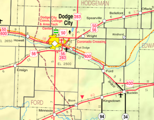
Major highways
 U.S. Route 50
 U.S. Route 54
 U.S. Route 56
 U.S. Route 283
 U.S. Route 400
 K-34
K-34
Demographics
| Historical population | |||
|---|---|---|---|
| Census | Pop. | %± | |
| 1870 | 427 | — | |
| 1880 | 3,122 | 631.1% | |
| 1890 | 5,308 | 70.0% | |
| 1900 | 5,497 | 3.6% | |
| 1910 | 11,393 | 107.3% | |
| 1920 | 14,273 | 25.3% | |
| 1930 | 20,647 | 44.7% | |
| 1940 | 17,254 | −16.4% | |
| 1950 | 19,670 | 14.0% | |
| 1960 | 20,938 | 6.4% | |
| 1970 | 22,587 | 7.9% | |
| 1980 | 24,315 | 7.7% | |
| 1990 | 27,463 | 12.9% | |
| 2000 | 32,458 | 18.2% | |
| 2010 | 33,848 | 4.3% | |
| 2020 | 34,287 | 1.3% | |
| U.S. Decennial Census[5] 1790-1960[6] 1900-1990[7] 1990-2000[8] 2010-2020[1] | |||

The Dodge City Micropolitan Statistical Area includes all of Ford County.
As of the 2000 census,[9] 33,848 people, 10,852 households, and 7,856 families were residing in the county. The population density was 30 people/sq mi (11/km2). The 11,650 housing units averaged 11/sq mi (4/km2). The racial makeup of the county was 75.3% White, 2.1% African American, 1.0% Native American, 1.4% Asian, 0.2% Pacific Islander, 17.8% from other races, and 2.7% from two or more races. Hispanic and Latino Americans of any race were 51.2% of the population.
Of the 10,852 households, 40.90% had children under the age of 18 living with them, 57.90% were married couples living together, 9.20% had a female householder with no husband present, and 27.60% were not families. About 22.70% of all households were made up of individuals, and 9.50% had someone living alone who was 65 years of age or older. The average household size was 2.92, and the average family size was 3.42.
In the county, the age distribution was 31.10% under 18, 11.20% from 18 to 24, 29.40% from 25 to 44, 17.30% from 45 to 64, and 11.00% who were 65 or older. The median age was 30 years. For every 100 females, there were 107.20 males. For every 100 females age 18 and over, there were 105.30 males.
The median income for a household in the county was $37,860, and for a family was $42,734. Males had a median income of $27,189 versus $22,165 for females. The per capita income for the county was $15,721. About 9.90% of families and 12.40% of the population were below the poverty line, including 15.40% of those under age 18 and 8.40% of those age 65 or over.
Government
Presidential elections
Ford County has been strongly Republican for most of its history, especially in recent elections. Only eight Democratic presidential candidates from 1880 to 2020 have carried the county, the most recent being Jimmy Carter in 1976.
| Year | Republican | Democratic | Third party | |||
|---|---|---|---|---|---|---|
| No. | % | No. | % | No. | % | |
| 2020 | 5,803 | 65.09% | 2,947 | 33.06% | 165 | 1.85% |
| 2016 | 5,114 | 66.26% | 2,149 | 27.84% | 455 | 5.90% |
| 2012 | 5,602 | 66.99% | 2,600 | 31.09% | 160 | 1.91% |
| 2008 | 5,730 | 64.64% | 2,991 | 33.74% | 143 | 1.61% |
| 2004 | 6,632 | 73.56% | 2,286 | 25.35% | 98 | 1.09% |
| 2000 | 6,050 | 67.85% | 2,566 | 28.78% | 301 | 3.38% |
| 1996 | 5,681 | 61.30% | 2,628 | 28.36% | 958 | 10.34% |
| 1992 | 4,342 | 41.93% | 2,635 | 25.44% | 3,379 | 32.63% |
| 1988 | 5,685 | 58.63% | 3,817 | 39.36% | 195 | 2.01% |
| 1984 | 6,935 | 69.72% | 2,914 | 29.30% | 98 | 0.99% |
| 1980 | 5,686 | 58.86% | 3,194 | 33.06% | 781 | 8.08% |
| 1976 | 4,679 | 47.61% | 4,934 | 50.21% | 214 | 2.18% |
| 1972 | 6,232 | 67.12% | 2,804 | 30.20% | 249 | 2.68% |
| 1968 | 4,645 | 52.80% | 3,191 | 36.27% | 961 | 10.92% |
| 1964 | 3,481 | 39.73% | 5,221 | 59.59% | 59 | 0.67% |
| 1960 | 5,200 | 57.67% | 3,792 | 42.05% | 25 | 0.28% |
| 1956 | 5,561 | 66.84% | 2,710 | 32.57% | 49 | 0.59% |
| 1952 | 6,359 | 68.96% | 2,748 | 29.80% | 114 | 1.24% |
| 1948 | 4,089 | 47.21% | 4,396 | 50.75% | 177 | 2.04% |
| 1944 | 4,110 | 57.23% | 2,994 | 41.69% | 77 | 1.07% |
| 1940 | 4,356 | 51.97% | 3,954 | 47.17% | 72 | 0.86% |
| 1936 | 3,378 | 38.69% | 5,335 | 61.11% | 17 | 0.19% |
| 1932 | 3,335 | 41.61% | 4,442 | 55.42% | 238 | 2.97% |
| 1928 | 4,893 | 71.59% | 1,870 | 27.36% | 72 | 1.05% |
| 1924 | 3,449 | 57.99% | 1,551 | 26.08% | 948 | 15.94% |
| 1920 | 3,305 | 61.90% | 1,879 | 35.19% | 155 | 2.90% |
| 1916 | 2,337 | 40.29% | 3,044 | 52.47% | 420 | 7.24% |
| 1912 | 529 | 19.18% | 1,125 | 40.79% | 1,104 | 40.03% |
| 1908 | 1,333 | 53.28% | 1,089 | 43.53% | 80 | 3.20% |
| 1904 | 1,148 | 64.79% | 526 | 29.68% | 98 | 5.53% |
| 1900 | 653 | 50.46% | 610 | 47.14% | 31 | 2.40% |
| 1896 | 555 | 45.75% | 643 | 53.01% | 15 | 1.24% |
| 1892 | 648 | 53.42% | 0 | 0.00% | 565 | 46.58% |
| 1888 | 882 | 52.47% | 630 | 37.48% | 169 | 10.05% |
Laws
Ford County was a prohibition, or "dry", county until the Kansas Constitution was amended in 1986 and voters approved the sale of alcoholic liquor by the individual drink with a 30% food sales requirement.[11]
Education
Colleges
- Dodge City Community College
Unified school districts
- Spearville USD 381
- Dodge City USD 443
- Bucklin USD 459
Communities
Cities
Census-designated places
- Fort Dodge
- Wilroads Gardens
- Wright
Other unincorporated places
- Bellefont
- Bloom
- Kingsdown
- Windhorst
Townships
Ford County is divided into 14 townships. The city of Dodge City is considered governmentally independent and is excluded from the census figures for the townships. In the following table, the population center is the largest city (or cities) included in that township's population total, if it is of a significant size.
| Township | FIPS | Population center |
Population | Population density /km2 (/sq mi) |
Land area km2 (sq mi) | Water area km2 (sq mi) | Water % | Geographic coordinates |
|---|---|---|---|---|---|---|---|---|
| Bloom | 07375 | 113 | 1 (2) | 144 (55) | 0 (0) | 0% | 37°30′23″N 99°55′4″W | |
| Bucklin | 09025 | 900 | 3 (8) | 285 (110) | 0 (0) | 0.02% | 37°34′44″N 99°37′9″W | |
| Concord | 15150 | 117 | 1 (2) | 187 (72) | 0 (0) | 0.11% | 37°36′36″N 100°5′52″W | |
| Dodge | 18225 | 899 | 13 (33) | 70 (27) | 0 (0) | 0.21% | 37°47′0″N 100°0′52″W | |
| Enterprise | 21450 | 1,113 | 6 (17) | 175 (67) | 0 (0) | 0.19% | 37°40′47″N 99°57′8″W | |
| Fairview | 22500 | 346 | 2 (5) | 188 (73) | 0 (0) | 0.06% | 37°45′11″N 100°8′57″W | |
| Ford | 23750 | 456 | 2 (5) | 249 (96) | 0 (0) | 0.01% | 37°36′58″N 99°46′27″W | |
| Grandview | 27350 | 784 | 3 (9) | 226 (87) | 0 (0) | 0.20% | 37°47′10″N 99°55′54″W | |
| Richland | 59300 | 931 | 9 (24) | 99 (38) | 0 (0) | 0.17% | 37°42′10″N 100°2′19″W | |
| Royal | 61575 | 105 | 1 (1) | 185 (72) | 0 (0) | 0.06% | 37°51′51″N 100°6′44″W | |
| Sodville | 66150 | 110 | 1 (2) | 145 (56) | 0 (0) | 0.01% | 37°31′16″N 99°45′6″W | |
| Spearville | 67150 | 1,150 | 2 (6) | 479 (185) | 0 (0) | 0.03% | 37°47′58″N 99°45′4″W | |
| Wheatland | 77675 | 170 | 1 (2) | 193 (74) | 0 (0) | 0% | 37°48′58″N 99°37′22″W | |
| Wilburn | 79100 | 88 | 0 (1) | 187 (72) | 0 (0) | 0% | 37°31′22″N 100°7′10″W | |
| Sources: "Census 2000 U.S. Gazetteer Files". U.S. Census Bureau, Geography Division. Archived from the original on August 2, 2002. | ||||||||
Notable people
Numerous figures of the American Old West lived in Dodge City during its period as a frontier cowtown. These included, most notably, lawmen Wyatt Earp and Bat Masterson, and gunfighter Doc Holliday.[12]
See also
- National Register of Historic Places listings in Ford County, Kansas
|
|
References
- "QuickFacts; Ford County, Kansas; Population, Census, 2020 & 2010". United States Census Bureau. Archived from the original on August 16, 2021. Retrieved August 16, 2021.
- "Find a County". National Association of Counties. Archived from the original on May 9, 2015. Retrieved June 7, 2011.
- Gannett, Henry (1905). The Origin of Certain Place Names in the United States. Govt. Print. Off. pp. 128.
- "US Gazetteer files: 2010, 2000, and 1990". United States Census Bureau. February 12, 2011. Retrieved April 23, 2011.
- "U.S. Decennial Census". United States Census Bureau. Retrieved July 24, 2014.
- "Historical Census Browser". University of Virginia Library. Retrieved July 24, 2014.
- "Population of Counties by Decennial Census: 1900 to 1990". United States Census Bureau. Retrieved July 24, 2014.
- "Census 2000 PHC-T-4. Ranking Tables for Counties: 1990 and 2000" (PDF). United States Census Bureau. Retrieved July 24, 2014.
- "U.S. Census website". United States Census Bureau. Retrieved October 19, 2018.
- "Dave Leip's Atlas of U.S. Presidential Elections".
- "Map of Wet and Dry Counties". Alcoholic Beverage Control, Kansas Department of Revenue. November 2006. Archived from the original on October 8, 2007. Retrieved December 28, 2007.
- "More Dodge City History". Dodge City Convention and Visitors Bureau. Retrieved September 23, 2011.
Further reading
- Handbook of Ford County, Kansas; C.S. Burch Publishing Co; 32 pages; 1887.
- Atlas and Plat Book of Ford County, Kansas; Kenyon Co; 54 pages; 1916.
- Standard Atlas of Ford County, Kansas; Geo. A. Ogle & Co; 63 pages; 1906.
External links
- County
- Historical
- Ford County History from FCHS, Dodge City, KS
- Ford County GenWeb
- Ford County from American History and Genealogy Project (AHGP)
- Maps
- Ford County Maps: Current, Historic, KDOT
- Kansas Highway Maps: Current, Historic, KDOT
- Kansas Railroad Maps: Current, 1996, 1915, KDOT and Kansas Historical Society
Places adjacent to Ford County, Kansas | ||||||||||||||||
|---|---|---|---|---|---|---|---|---|---|---|---|---|---|---|---|---|
| ||||||||||||||||
Municipalities and communities of Ford County, Kansas, United States | ||
|---|---|---|
County seat: Dodge City | ||
| Cities |  | |
| Unincorporated communities |
| |
| Townships |
| |
| Footnotes | †This community is designated a Census-Designated Place (CDP) by the United States Census Bureau. | |
| ||
Topeka (capital) | ||
| Topics |
|  Seal of Kansas |
| Society |
| |
| Regions |
| |
| Largest cities |
| |
| Counties |
| |
| Lists |
| |
Authority control | |
|---|---|
| General | |
| National libraries | |
| Other | |
На других языках
- [en] Ford County, Kansas
[ru] Форд (округ, Канзас)
Округ Форд (англ. Ford County) располагается в штате Канзас, США. Официально образован 26-го февраля 1867 года. По состоянию на 2010 год, численность населения составляла 33 848 человека.Другой контент может иметь иную лицензию. Перед использованием материалов сайта WikiSort.org внимательно изучите правила лицензирования конкретных элементов наполнения сайта.
WikiSort.org - проект по пересортировке и дополнению контента Википедии