world.wikisort.org - USA
Archer City is a city in and the county seat of Archer County, Texas, United States. The city lies at the junction of State Highway 79 and State Highway 25. It is located 25 miles (40 km) south of Wichita Falls, and is part of the Wichita Falls metropolitan statistical area. Its population was 1,834 at the 2010 census.[5]
Archer City, Texas | |
|---|---|
City | |
 Downtown Archer City, Texas | |
 Location of Archer City, Texas | |
 Archer City Location in Texas  Archer City Location in the United States | |
| Coordinates: 33°35′39″N 98°37′35″W | |
| Country | United States |
| State | Texas |
| County | Archer |
| Government | |
| • Mayor | Kelvin Green |
| Area | |
| • Total | 2.22 sq mi (5.76 km2) |
| • Land | 2.19 sq mi (5.68 km2) |
| • Water | 0.03 sq mi (0.08 km2) |
| Elevation | 1,066 ft (325 m) |
| Population (2010) | |
| • Total | 1,834 |
| • Estimate (2019)[3] | 1,702 |
| • Density | 776.46/sq mi (299.78/km2) |
| Time zone | UTC-6 (Central (CST)) |
| • Summer (DST) | UTC-5 (CDT) |
| ZIP code | 76351 |
| Area code | 940 |
| FIPS code | 48-03696[4] |
| GNIS feature ID | 1351239[2] |
| Website | www |

The city is named for Branch Tanner Archer, a commissioner for the Republic of Texas.[6][7][8][9]
Geography
Archer City is located at 33°35′39″N 98°37′35″W (33.594036, –98.626499).[10]
According to the United States Census Bureau, the city has a total area of 2.2 sq mi (5.7 km2), of which 0.04 sq mi (0.10 km2) is covered by water.
Demographics
| Historical population | |||
|---|---|---|---|
| Census | Pop. | %± | |
| 1910 | 825 | — | |
| 1920 | 689 | −16.5% | |
| 1930 | 1,512 | 119.4% | |
| 1940 | 1,675 | 10.8% | |
| 1950 | 1,901 | 13.5% | |
| 1960 | 1,974 | 3.8% | |
| 1970 | 1,722 | −12.8% | |
| 1980 | 1,862 | 8.1% | |
| 1990 | 1,748 | −6.1% | |
| 2000 | 1,848 | 5.7% | |
| 2010 | 1,834 | −0.8% | |
| 2019 (est.) | 1,702 | [3] | −7.2% |
| U.S. Decennial Census[11] | |||
2020 census
| Race | Number | Percentage |
|---|---|---|
| White (NH) | 1,372 | 85.7% |
| Black or African American (NH) | 14 | 0.87% |
| Native American or Alaska Native (NH) | 18 | 1.12% |
| Asian (NH) | 2 | 0.12% |
| Some Other Race (NH) | 3 | 0.19% |
| Mixed/Multi-Racial (NH) | 75 | 4.68% |
| Hispanic or Latino | 117 | 7.31% |
| Total | 1,601 |
As of the 2020 United States census, there were 1,601 people, 717 households, and 340 families residing in the city.
2010 census
As of the census[4] of 2010, 1,834 people, 758 households, and 506 families were residing in the city. The population density was 837.3 people/sq mi (322.9/km2). The 869 housing units averaged 393.7/sq mi (151.8/km2). The racial makeup of the city was 97.56% White, 0.70% Native American, 0.81% from other races, and 0.92% from two or more races. Hispanic or Latino of any race were 2.33% of the population.
Of the 758 households, 33.5% had children under 18 living with them, 56.2% were married couples living together, 8.4% had a female householder with no husband present, and 33.2% were not families. About 30.5% of all households were made up of individuals, and 14.6% had someone living alone who was 65 or older. The average household size was 2.38,and the average family size was 2.99.
In the city, the age distribution was 25.6% under 18, 7.5% from 18 to 24, 25.9% from 25 to 44, 22.5% from 45 to 64, and 18.5% who were 65 or older. The median age was 39 years. For every 100 females, there were 88.6 males. For every 100 females age 18 and over, there were 83.1 males.
The median income for a household in the city was $29,886, and for a family was $36,563. Males had a median income of $29,524 versus $18,977 for females. The per capita income for the city was $19,140. About 11.3% of families and 13.5% of the population were below the poverty line, including 13.8% of those under age 18 and 17.9% of those age 65 or over.
Government and infrastructure
Kelvin Green was elected mayor of Archer City in 2014 at the age of 18. He ran unopposed and was in high school. He was re-elected in 2017.[15]
Eight miles (12.8 km) west-southwest of the city lies a 2-mile (3.2 km) antenna, the Lake Kickapoo Field Station, operated by the 20th Space Control Squadron, and part of the Air Force Space Surveillance System, used for observing objects passing over the United States. It is the primary anchor transmitter for the Space Command southern "fence" (or "Space Fence") network for monitoring the space defense system. It extends east-to-west across America at about 33°N. The antenna has no public access and restricted entry.[16][17]
Education
Archer City is served by the Archer City Independent School District, with one campus consisting of Archer City High School (grades 7–12) and Archer City Elementary School (grades K–6).
Notable people
- Angela Kinsey, Actress best known for portraying Angela Martin in the comedy series The Office
- Larry McMurtry, Novelist and screenwriter known for Terms of Endearment, Pulitzer Prize-winning Lonesome Dove, and The Last Picture Show, the latter of which was filmed in Archer City[6][18][19]
- Graham B. Purcell, Jr., U.S. representative from Texas's 13th congressional district from 1962 to 1973, was born in Archer City in 1919
Climate
The climate in this area is characterized as very hot, with humid summers and generally mild to cool winters. According to the Köppen climate classification, Archer City has a humid subtropical climate, Cfa on climate maps.[20]
Gallery
 Archer County Courthouse
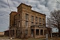 County Courthouse Jail
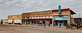 Downtown Archer City
 City Hall in Archer City
 Historic buildings in Archer City


References
- "2019 U.S. Gazetteer Files". United States Census Bureau. Retrieved August 7, 2020.
- U.S. Geological Survey Geographic Names Information System: Archer City, Texas
- "Population and Housing Unit Estimates". United States Census Bureau. May 24, 2020. Retrieved May 27, 2020.
- "U.S. Census website". United States Census Bureau. Retrieved 2008-01-31.
- "Find a County". National Association of Counties. Archived from the original on 2011-05-31. Retrieved 2011-06-07.
- Archer City, Texas from the Handbook of Texas Online
- Branch Tanner Archer from the Handbook of Texas Online
- Branch T. Archer (1790-1856) - at the Lone Star Junction
- Branch Tanner Archer - at the Naval Historical Center
- "US Gazetteer files: 2010, 2000, and 1990". United States Census Bureau. 2011-02-12. Retrieved 2011-04-23.
- "Census of Population and Housing". Census.gov. Retrieved June 4, 2015.
- "Explore Census Data". data.census.gov. Retrieved 2022-05-19.
- http://www.census.gov [not specific enough to verify]
- "About the Hispanic Population and its Origin". www.census.gov. Retrieved 18 May 2022.
- Campion, Steve (7 November 2017). "Texas' youngest mayor barely old enough to drink". KTRK-TV Houston. Retrieved 8 November 2017.
- US Naval Space Command Space Surveillance System - at the Federation of American Scientists
- Eyeballing the Lake Kickapoo Space Surveillance Station - at Trust Us
- Filming locations for The Last Picture Show - at IMDb
- Filming locations for Texasville - at IMDb
- Climate Summary for Archer City, Texas
External links
- Archer City
- Archer City Independent School District Official Website
- Archer City from the Handbook of Texas Online
Municipalities and communities of Archer County, Texas, United States | ||
|---|---|---|
County seat: Archer City | ||
| Cities |  | |
| Towns | ||
| Unincorporated communities |
| |
| Ghost towns |
| |
| Footnotes | ‡This populated place also has portions in an adjacent county or counties | |
| ||
State of Texas | |
|---|---|
Austin (capital) | |
| Topics |
|
| Society |
|
| Regions |
|
| Metropolitan areas |
|
| Counties | See: List of counties in Texas |
Authority control | |
|---|---|
| General |
|
| National libraries | |
| Other | |
На других языках
- [en] Archer City, Texas
[ru] Арчер-Сити
Арчер-Сити (англ. Archer City) — город в США, расположенный в северной части штата Техас, административный центр округа Арчер. По данным переписи за 2010 год число жителей составляло 1834 человека[2], по оценке Бюро переписи США в 2018 году в городе проживало 1772 человека[3].Другой контент может иметь иную лицензию. Перед использованием материалов сайта WikiSort.org внимательно изучите правила лицензирования конкретных элементов наполнения сайта.
WikiSort.org - проект по пересортировке и дополнению контента Википедии