world.wikisort.org - USA
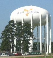
Texarkana is a city in Bowie County, Texas, United States, in the Ark-La-Tex region. Located approximately 180 miles (290 km) from Dallas, Texarkana is a twin city with neighboring Texarkana, Arkansas. The Texas city's population was 36,193 at the 2020 census.[4]
Texarkana, Texas | |
|---|---|
City | |
 Texarkana Texas City Hall | |
| Nickname(s): The Texas Side, T-Town, TK, TXK, Twin City | |
| Motto(s): Twice as Nice | |
 Location of Texarkana, Texas | |
 Texarkana, Texas Location in US  Texarkana, Texas Texarkana, Texas (Texas) | |
| Coordinates: 33°26′14″N 94°04′03″W | |
| Country | |
| State | |
| County | Bowie |
| Government | |
| • Type | Council-Manager |
| • City Council | Mayor Bob Bruggeman Jean H. Matlock Mary Hart Betty Williams Christie Page Bill Harp Jay Davis |
| • City Manager | David Orr, Ph.D. |
| Area | |
| • Total | 29.47 sq mi (76.33 km2) |
| • Land | 29.03 sq mi (75.20 km2) |
| • Water | 0.44 sq mi (1.13 km2) |
| Elevation | 299 ft (91 m) |
| Population (2020) | |
| • Total | 36,193 |
| • Density | 1,228.13/sq mi (474.16/km2) |
| Time zone | UTC−6 (Central (CST)) |
| • Summer (DST) | UTC−5 (CDT) |
| ZIP codes | 755XX. |
| Area codes | 903, 430 |
| FIPS code | 48-72368[2] |
| GNIS feature ID | 1369752[3] |
| Website | ci |
The city and its Arkansas counterpart form the core of the Texarkana Metropolitan Statistical Area, encompassing all of Bowie County, Texas, and Miller County, Arkansas. The two cities had a combined population of 65,580 in the 2020 decennial census, and the metropolitan area had a population of 149,482.[5]
History
Railroads were quick to see the possibilities of connecting markets in this vast area. In the late 1850s, the builders of the Cairo and Fulton Railroad were pushing their line steadily south across Arkansas. By 1874, they crossed the Red River and reached the Texas state line. Between February 16 and March 19, 1874, trains ran between the Texas border and the Red River, whence passengers and freight were ferried north to Fulton, Arkansas to continue by rail. The Red River Bridge opened on March 20, 1874. Since then, trains have run directly from Texarkana to St. Louis, Missouri.
Keen rivalry existed between the 1870s railroad builders. The Texas and Pacific Railroad reached across Texas to the Arkansas state line. The border was the logical place for the different railways to connect. On December 8, 1873, the Texas and Pacific sold the first town lots for the future city. The first buyer was J. W. Davis,[6] who purchased the land where today's Hotel McCartney now stands, opposite Union Station.
The name Texarkana is known to be a portmanteau of Texas, Arkansas, and nearby Louisiana. However, accounts of the name's origin differ, and it had been in use some time before the town was founded. The most popular tradition is that when the St. Louis, Iron Mountain and Southern Railway was building its line through the area, Col. Gus Knobel, a railroad surveyor, coined the name. He is said to have painted it on a plank and nailed it to a tree, saying "This is the name of a town which is to be built here."[7] Another story tells of a Red River steamboat named The Texarkana, c. 1860. A third account relates that a storekeeper named Swindle in Red Land, Louisiana, concocted a drink called "Texarkana Bitters".[8]
20th century to present
Racial discrimination continued after the abolition of slavery in both states. Violent attacks on blacks and lynchings took place, especially in the late 19th and early 20th centuries. Blacks were largely disenfranchised throughout the South from the turn of the century until after passage of federal voting rights legislation in 1965 and enforcement. On May 22, 1922, Hullen Owens, an African-American man, was lynched by a large white mob made up of thousands of people.[9]
In the late winter and spring of 1946, from February 22 to May 3, residents of the two cities were terrorized by violent attacks against four young couples. Five of the eight individuals were killed, in what were called the Texarkana Moonlight Murders. Law enforcement believed the attacks to be the work of a serial killer, but no one was ever prosecuted for these crimes. The attacks took place in both Texarkana, Arkansas, and the twin city area in Texas.
Geography
Texarkana is located at the junction of Interstate 30 and US highways 59, 67, 71, and 82 in extreme northeast Texas on the Texas-Arkansas border,[10] at 33°26′14″N 94°4′3″W (33.437170, –94.067394).[11] It is bordered by the city of Texarkana, Arkansas, to the east, and by the smaller cities of Nash and Wake Village, Texas, to the west. It is in the Central Time Zone.
According to the United States Census Bureau, the Texas city has a total area of 29.5 square miles (76.3 km2), of which 29.0 square miles (75.2 km2) is land and 0.42 square miles (1.1 km2), or 1.39%, is covered by water.[4] The city is roughly 180 miles northeast of Dallas.
Climate
- The warmest month is August.
- The highest recorded temperature was 117 °F (47 °C) in 1936.
- On average, the coolest month is January.
- The lowest recorded temperature was –6 °F (–21 °C) in 1989.
- The most precipitation on average occurs in November.
- A humid subtropical climate (Cfa) exists in the region.
| Climate data for Texarkana, Texas (1991–2020 normals, extremes 1968–present) | |||||||||||||
|---|---|---|---|---|---|---|---|---|---|---|---|---|---|
| Month | Jan | Feb | Mar | Apr | May | Jun | Jul | Aug | Sep | Oct | Nov | Dec | Year |
| Record high °F (°C) | 81 (27) |
89 (32) |
89 (32) |
95 (35) |
98 (37) |
105 (41) |
105 (41) |
112 (44) |
108 (42) |
95 (35) |
87 (31) |
83 (28) |
112 (44) |
| Average high °F (°C) | 54.3 (12.4) |
58.6 (14.8) |
66.7 (19.3) |
74.8 (23.8) |
82.0 (27.8) |
89.3 (31.8) |
93.3 (34.1) |
93.5 (34.2) |
87.2 (30.7) |
76.7 (24.8) |
64.8 (18.2) |
56.3 (13.5) |
74.8 (23.8) |
| Daily mean °F (°C) | 43.7 (6.5) |
47.6 (8.7) |
55.2 (12.9) |
63.1 (17.3) |
71.8 (22.1) |
79.6 (26.4) |
83.2 (28.4) |
82.8 (28.2) |
76.2 (24.6) |
64.9 (18.3) |
53.6 (12.0) |
46.1 (7.8) |
64.0 (17.8) |
| Average low °F (°C) | 33.1 (0.6) |
36.6 (2.6) |
43.8 (6.6) |
51.4 (10.8) |
61.7 (16.5) |
69.8 (21.0) |
73.0 (22.8) |
72.1 (22.3) |
65.2 (18.4) |
53.2 (11.8) |
42.4 (5.8) |
35.8 (2.1) |
53.2 (11.8) |
| Record low °F (°C) | 2 (−17) |
−3 (−19) |
15 (−9) |
28 (−2) |
38 (3) |
52 (11) |
57 (14) |
55 (13) |
38 (3) |
27 (−3) |
16 (−9) |
−6 (−21) |
−6 (−21) |
| Average precipitation inches (mm) | 4.26 (108) |
4.58 (116) |
4.70 (119) |
4.88 (124) |
5.25 (133) |
4.39 (112) |
3.40 (86) |
2.77 (70) |
3.89 (99) |
4.78 (121) |
4.33 (110) |
5.18 (132) |
52.41 (1,331) |
| Average snowfall inches (cm) | 1.0 (2.5) |
1.0 (2.5) |
0.0 (0.0) |
0.0 (0.0) |
0.0 (0.0) |
0.0 (0.0) |
0.0 (0.0) |
0.0 (0.0) |
0.0 (0.0) |
0.0 (0.0) |
0.0 (0.0) |
0.1 (0.25) |
2.1 (5.3) |
| Average precipitation days (≥ 0.01 in) | 11.0 | 11.2 | 10.8 | 9.7 | 10.3 | 8.5 | 6.8 | 6.5 | 6.7 | 8.6 | 9.1 | 10.6 | 109.8 |
| Average snowy days (≥ 0.1 in) | 0.3 | 0.4 | 0.0 | 0.0 | 0.0 | 0.0 | 0.0 | 0.0 | 0.0 | 0.0 | 0.0 | 0.1 | 0.8 |
| Source: NOAA[12][13] | |||||||||||||
On May 22, 2008, a microburst producing winds up to 100 mph occurred over Stateline Avenue and surrounding communities. An analysis of radar data leading up to the damage showed that two severe thunderstorms came together on the south side of the city. One severe storm was moving northeastward from southern Bowie County, while the other was moving northwestward through Miller County. Both storms collided in an area just south of downtown Texarkana.[citation needed]
Demographics
| Historical population | |||
|---|---|---|---|
| Census | Pop. | %± | |
| 1880 | 1,833 | — | |
| 1890 | 2,852 | 55.6% | |
| 1900 | 5,256 | 84.3% | |
| 1910 | 9,790 | 86.3% | |
| 1920 | 11,480 | 17.3% | |
| 1930 | 16,602 | 44.6% | |
| 1940 | 17,019 | 2.5% | |
| 1950 | 24,753 | 45.4% | |
| 1960 | 30,218 | 22.1% | |
| 1970 | 30,497 | 0.9% | |
| 1980 | 31,271 | 2.5% | |
| 1990 | 31,656 | 1.2% | |
| 2000 | 34,782 | 9.9% | |
| 2010 | 36,411 | 4.7% | |
| 2020 | 36,193 | −0.6% | |
| U.S. Decennial Census[14] | |||
| Race | Number | Percentage |
|---|---|---|
| White (NH) | 16,825 | 46.49% |
| Black or African American (NH) | 13,565 | 37.48% |
| Native American or Alaska Native (NH) | 164 | 0.45% |
| Asian (NH) | 736 | 2.03% |
| Pacific Islander (NH) | 25 | 0.07% |
| Some Other Race (NH) | 173 | 0.48% |
| Mixed/Multi-Racial (NH) | 1,613 | 4.46% |
| Hispanic or Latino | 3,092 | 8.54% |
| Total | 36,193 |
According to the 2020 United States census, there were 36,193 people, 14,148 households, and 8,767 families residing in the city. The population density was 1,228.13 inhabitants per square mile (474.18/km2). The 16,270 housing units averaged 589.4 per square mile (227.5/km2). Of the 16,280 households, 31.5% had children under the age of 18 living with them, 42.5% were married couples living together, 19.3% had a female householder with no husband present. and 34.1% were not families; 29.9% of all households were made up of individuals, and 12.1% had someone living alone who was 65 years of age or older. The average household size was 2.42 and the average family size was 3.01.
In the city, the age distribution of the population was 26.0% under the age of 18, 10.0% from 18 to 24, 27.6% from 25 to 44, 20.7% from 45 to 64, and 15.7% who were 65 years of age or older. The median age was 36 years. For every 100 females, there were 89.0 males. For every 100 females age 18 and over, there were 84.4 males.
The median income for a household in the city was $29,727, and for a family was $39,119. Males had a median income of $34,155 versus $21,143 for females. The per capita income for the city was $17,815. About 19.4% of families and 24.0% of the population were below the poverty line, including 34.8% of those under age 18 and 13.2% of those age 65 or over. The most affluent area of Texarkana is Pleasant Grove, where the median income is $49,562 for each household and the median for a family is $57,219 in 2013.
Economy
According to the city's 2009 Comprehensive Annual Financial Report,[18] the top employers in the city are:
| # | Employer | # of Employees |
|---|---|---|
| 1 | Red River Army Depot and tenants | 7,200 |
| 2 | Christus St. Michael Health Care | 1,883 |
| 3 | Cooper Tire & Rubber Company | 1,700 |
| 4 | Domtar | 1,300 |
| 5 | Wal-Mart | 1,100 |
| 6 | International Paper | 920 |
| 7 | Wadley Regional Medical Center | 850 |
| 8 | Texarkana Independent School District | 795 |
| 9 | Texarkana Arkansas School District | 785 |
| 10 | Southern Refrigerated Transport | 750 |
Government
Local government
According to the city's most recent Comprehensive Annual Financial Report Fund Financial Statements, the city's various funds had $36.0 million in revenues, $37.0 million in expenditures, $18.9 million in total assets, $3.5 million in total liabilities, and $7.2 million in investments.[19]
Education
Public school districts
Schools in Texarkana, Texas, are under the jurisdiction of the Texarkana Independent School District, the Liberty-Eylau Independent, Pleasant Grove Independent School District, and Red Lick Independent School District.[20]
Colleges and universities
Texarkana is home to Texas A&M University–Texarkana, a four-year branch of the Texas A&M University System, and to Texarkana College, a community college.
Religion
Texarkana is the headquarters of the theologically conservative American Baptist Association, whose Missionary Baptist churches are most numerous in Texas, Arkansas, Louisiana, Oklahoma, and Mississippi.
State government
Though the city was historically Democratic, Texarkana is currently represented by Republicans in both houses of the Texas State Legislature. The state senator is Bryan Hughes from District 1. State Representative Gary VanDeaver represents Texas House District 1.
The Texas Department of Criminal Justice operates the Texarkana District Parole Office in Texarkana.[21]
The Texas Sixth Court of Appeals is located downtown in the Bi-State Justice Building.[22]
Federal government
At the federal level, the two U.S. senators from Texas are Republicans John Cornyn and Ted Cruz; Texarkana is part of Texas's 4th congressional district, which is currently represented by Republican Pat Fallon.
The Federal Courthouse (which also holds the downtown post office[23]) is located directly on the Arkansas-Texas state line and is the only federal office building to straddle a state line. During his campaign for the presidency, John F. Kennedy spoke on the steps of the courthouse September 13, 1960, and so did President Jimmy Carter, on October 22, 1980.[24]
The Federal Correctional Institution, Texarkana, is a Federal Bureau of Prisons facility in unincorporated Bowie County just outside the southwest border of the city.[25][26]
Transportation
Texarkana Regional Airport is located in Texarkana, Arkansas, and serves general aviation and American Eagle service to Dallas/Fort Worth International Airport.
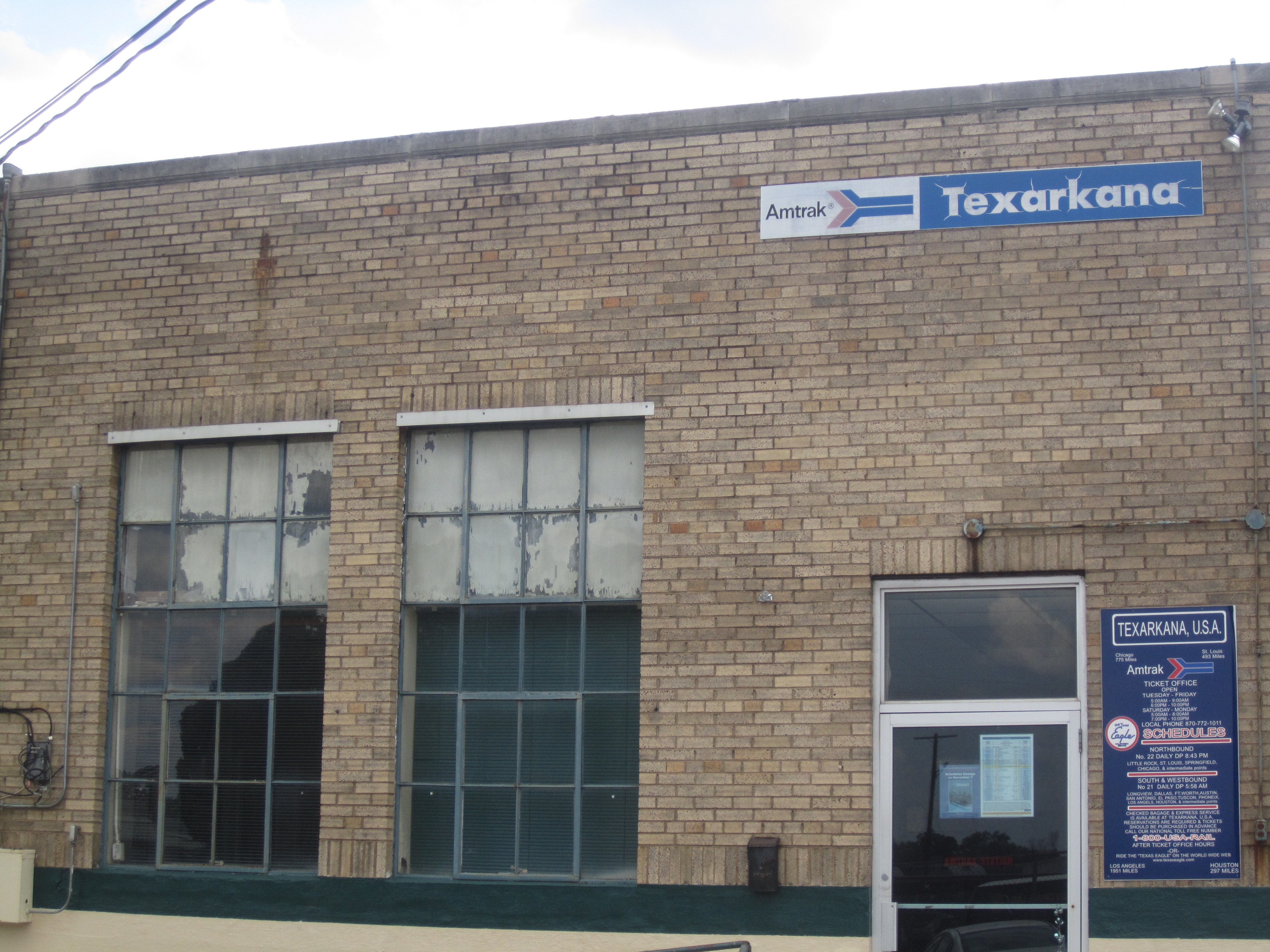
Texarkana Union Station is located in downtown Texarkana along the state line, with Amtrak's Texas Eagle providing daily service east to Chicago and west to San Antonio, continuing on to Los Angeles three days a week, with intermediate points.
The Texarkana Urban Transit District provides bus transportation to major areas of town along nine different routes. Service runs from 5:30 am to 6:20 pm Monday–Saturday.
Interstate 30 passes through Texarkana on the north. Loop 151 on the west of the city forms part of the Texarkana Loop, a three-quarter loop around the west, south, and east of the twin cities with I-30 completing the loop on the north. Interstate 369 shares the western portion of Loop 151. Interstate 49 is a newly constructed interstate corridor on the Arkansas side of the city which connects Texarkana to Shreveport, Louisiana.
Downtown murals
Across the Texarkana TX Arts & Historic District downtown, a colorful array of murals are for viewing. The murals have helped promote local talent and encouraged engagement from the community. Several murals have been used for social media and professional photos.
 Texarkana Kress murals
 Texarkana Scott Joplin mural
 Orchid Lady
 Texarkana Kress butterfly mural
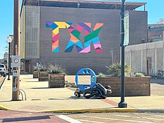 TXK mural
 Texarkana balloon mural


Notable people
- Joe Anderson, NFL wide receiver
- Miller Barber, golfer
- Jesse Belvin, singer, pianist, and songwriter
- Footsie Blair, (1900-1982) - was a Major League Baseball second baseman for the Chicago Cubs.
- J.B. Bobo, magician
- Ben M. Bogard, clergyman, founder of American Baptist Association in Texarkana in 1924[27]
- Willie Buchanon, football player
- Melvin Bunch, baseball player
- David Crowder, musician
- Robert Ealey, electric blues singer
- Carl Finch, musician, founder of Brave Combo
- Corinne Griffith, silent-film actress
- Harmonica Slim, blues harmonicist, singer, and songwriter[28]
- Rich Houston, football player
- V. E. Howard, clergyman who founded the International Gospel Hour and was the pastor of the Walnut Street Church of Christ in Texarkana[29]
- LaMichael James, football player for the San Francisco 49ers and Miami Dolphins
- Brandon Jones, NFL wide receiver
- Parnelli Jones, race car driver in International Motorsports Hall of Fame
- Scott Joplin, ragtime music composer and pianist
- Jeff Keith, lead singer of rock band Tesla
- Jarrion Lawson, American sprinter and long jumper
- Joshua Logan, film and stage director, Tony Award and Pulitzer Prize winner
- Ryan Mallett, NFL quarterback for Baltimore Ravens
- Eddie Mathews, baseball player in Hall of Fame
- Will Middlebrooks, baseball player for the Milwaukee Brewers
- Craig Monroe, baseball player
- Mac Morgan, opera singer
- Dustin Moseley, baseball player
- Ross Perot, businessman and politician
- Charles B. Pierce, movie producer
- Molly Quinn, actress
- John D. Raffaelli, American lobbyist
- James Theodore Richmond, writer, conservationist
- Bill Rogers, golfer
- Dame Marjorie Morris Scardino, Pulitzer Prize-winning publisher and CEO of Pearson PLC
- Michael Jarboe Sheehan, Roman Catholic Archbishop of Santa Fe
- Rod Smith, NFL player for Denver Broncos
- Drew Stubbs, baseball player for the Colorado Rockies
- Marshall Terrill, author
- Aysel Teymurzadeh, singer, performer
- Michael Trimble, opera singer, voice teacher[30]
- Nathan Vasher, football player
- Michael Wacha, baseball player for the St. Louis Cardinals
- Frank D. White, governor of Arkansas from 1981 to 1983
- Otis Williams, musician, founding member of The Temptations
Notes
References
- "2019 U.S. Gazetteer Files". United States Census Bureau. Retrieved August 7, 2020.
- "U.S. Census website". United States Census Bureau. Retrieved January 31, 2008.
- "US Board on Geographic Names". United States Geological Survey. October 25, 2007. Retrieved January 31, 2008.
- "Quick Facts: Texarkana city, Texas". U.S. Census Bureau. Retrieved April 27, 2022.
{{cite web}}: CS1 maint: url-status (link) - "Census Reporter: Texarkana, TX-Texarkana, AR Metro Area". Retrieved May 9, 2022.
{{cite web}}: CS1 maint: url-status (link) - "Happy Birthday, Texarkana: Our hometown is 145 years old today". Texarkana Gazette. December 7, 2018. Retrieved June 8, 2020.
- Compiled by workers of the Writers' Program of the Work Projects Administration in the State of Arkansas (1941). Arkansas: A Guide to the State. Arkansas State Planning Board. p. 198. ISBN 978-1-62376-004-5.
- The Handbook of Texas Online. Texas State Historical Association, University of North Texas.
- The Union Daily Times, May 20, 1922, p. 1.
- "Our City". Ci.texarkana.tx.us. Archived from the original on October 23, 2010. Retrieved December 29, 2010.
- "US Gazetteer files: 2010, 2000, and 1990". United States Census Bureau. February 12, 2011. Retrieved April 23, 2011.
- "NowData – NOAA Online Weather Data". National Oceanic and Atmospheric Administration. Retrieved June 22, 2021.
- "Station: Texarkana, TX". U.S. Climate Normals 2020: U.S. Monthly Climate Normals (1991-2020). National Oceanic and Atmospheric Administration. Retrieved June 22, 2021.
- "Census of Population and Housing". Census.gov. Retrieved May 4, 2022.
- "Explore Census Data". data.census.gov. Retrieved May 22, 2022.
- https://www.census.gov/ [not specific enough to verify]
- "About the Hispanic Population and its Origin". www.census.gov. Retrieved May 18, 2022.
- City of Texarkana 2009 CAFR Archived July 18, 2011, at the Wayback Machine. Retrieved November 15, 2010
- Archived November 3, 2013, at the Wayback Machine
- "Texas School District Locator". Tea-texas.maps.arcgls.com. Retrieved April 7, 2015.
- Parole Division Region I Archived September 28, 2011, at the Wayback Machine. Texas Department of Criminal Justice. Retrieved May 15, 2010.
- "Contact Information Archived January 25, 2010, at the Wayback Machine." Texas Sixth Court of Appeals. Retrieved March 10, 2010.
- "Post Office in Texarkana, TX - USPS Hours and Location". Uspspostoffices.com. Retrieved April 7, 2015.
- Walsh, Field (March 16, 2014). "Presidents Visiting Texarkana". Txktoday.com. Retrieved April 15, 2021.
- FCI Texarkana Contact Information. Federal Bureau of Prisons. Retrieved June 2, 2010
- Ward Map Archived January 27, 2011, at the Wayback Machine. City of Texarkana, Texas. Retrieved July 2, 2010
- "Benjamin Marcus Bogard (1868–1951)". Encyclopediaofarkansas.net. Retrieved August 2, 2013.
- Eagle, Bob; LeBlanc, Eric S. (2013). Blues - A Regional Experience. Santa Barbara: Praeger Publishers. p. 300. ISBN 978-0313344237.
- "Verna Elisha Howard (1911-2000)". Therestorationmovement.com. Archived from the original on December 25, 2013. Retrieved July 12, 2013.
- William H. Trent (1989). Treasured poems of America. Sparrowgrass Poetry Forum. p. 298. ISBN 9780923242015.
- "Jail stormed; Negro Lynched". The Union Daily Times. Union, South Carolina. May 20, 1922. pp. 1–4. ISSN 2471-0563. OCLC 13088988. Retrieved March 4, 2022.
External links
- City of Texarkana, Texas portal
- Texarkana Chamber of Commerce
- Handbook of Texas Online: Texarkana, Texas
- Texarkana Gazette
- Texarkana Convention & Visitors Bureau
Municipalities and communities of Bowie County, Texas, United States | ||
|---|---|---|
County seat: Boston | ||
| Cities |  | |
| Unincorporated communities |
| |
| Ghost towns | ||
| Footnotes | ‡This populated place also has portions in an adjacent county or counties | |
| ||
Austin (capital) | ||
| Topics |
|  Seal of Texas |
| Society |
| |
| Regions |
| |
| Metropolitan areas |
| |
| Counties | See: List of counties in Texas | |
Authority control | |
|---|---|
| General | |
| National libraries | |
| Other |
|
На других языках
[de] Texarkana (Texas)
Texarkana ist eine Stadt im Bowie County im Nordosten des US-Bundesstaates Texas an der Grenze zu Arkansas. Zusammen mit Texarkana, Arkansas bildet sie eine Zwillingsstadt, die auf der Grenze zwischen den Staaten Texas und Arkansas liegt. Die beiden Texarkanas bilden ein Zentrum des Ark-La-Tex-Großraumes, der Nordost-Texas, Südwest-Arkansas, Nordwest-Louisiana und Südost-Oklahoma umfasst.- [en] Texarkana, Texas
Другой контент может иметь иную лицензию. Перед использованием материалов сайта WikiSort.org внимательно изучите правила лицензирования конкретных элементов наполнения сайта.
WikiSort.org - проект по пересортировке и дополнению контента Википедии